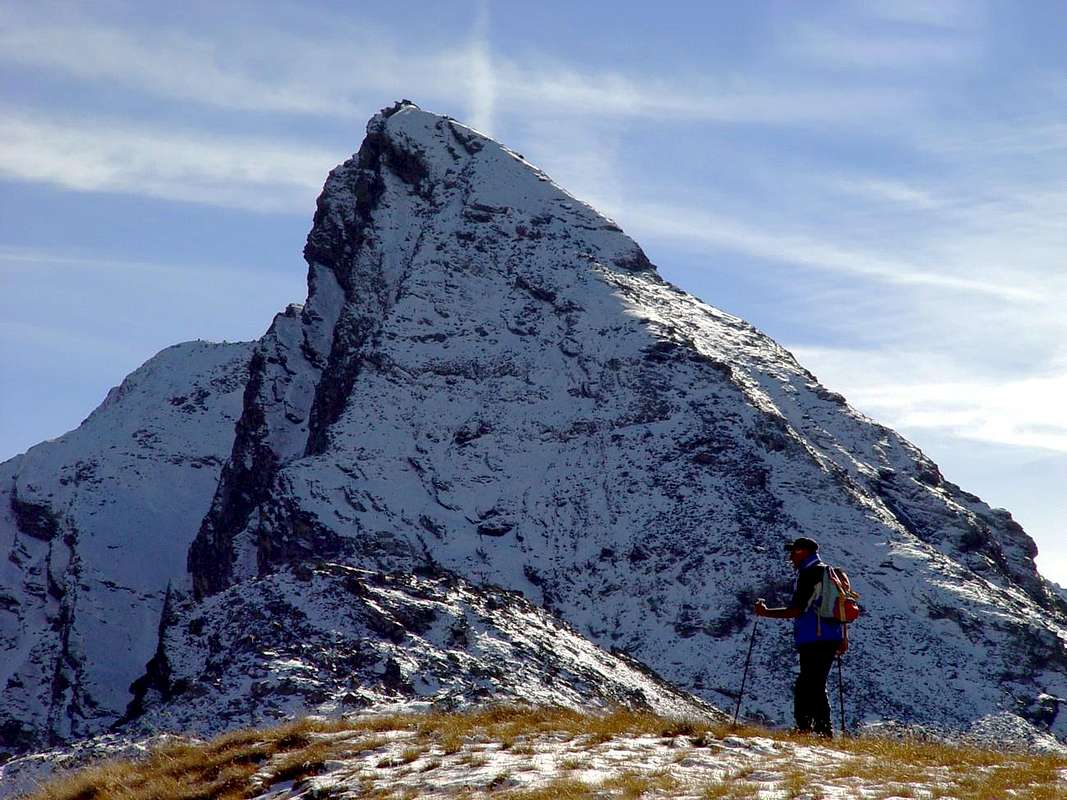
Small but beautiful pyramid, if observed by North and by Northwest, while from East it appears as square tower and cutted in point allowing to fall on the underlying Clavalité to tall vertical wall, constituted however by not good rock (burdens mountain climbers of Fénis Village, what Baptist Pieller and the Guides Maurice Gaillard, has effected burdens surveys on the same one, but they has had abdicated to for this motive; private informations Gaillard-Pieiller; Year 2000). Also the jagged South Crest, that ties him to the Great Crest "of the Devil", you can appear from an analysis from the attractive and fascinating lower part for his eccentric lines, but also for this the same considerations are worth; it would seem that some strong mountain climbers have tried to cross abdicating it for the really bad quality of the rock (you See Guide C.A.I. of the Series Italian Mountains "Emilius Rosa Banchi Parco del M. Avic", by Giulio Berutto e Lino Fornelli, Edit. March 2005, page 175). The same, while on the Oriental Slope "it accompanies" you fall her extreme crags of the East Wall, on the side of Saint Marcel it goes to melt himself with the Wall Southwest, that falls in direction of the Plan of Emonin Dessus or Superior; it is formed from a basal clog of more compact rocks, very steep and bluish that, after hundred meters, they meet in a great fault of fracture characterized by his form to turned arc in low. It follows in the median part a line flared of minced rocks that meet in the terminal part, formed by steep rocks and you crumble and of similar composition to those of the adjoining South Crest. On the opposite side of the wall, a rather steep Edge Southwest directly climbs and linearly to the Peak, dividing this from that West, revolt mostly in the two Alps of Plan Rué. As it regards the West Wall, the same one goes down with more lines "soft" toward the underlying two Alps of Plan Rué and the Plan of the Emonin; formed by two parallel ribs of which the most Northern form an edge with the Slope North-northwest. Introduces an easy climb, fast (in the first ascension you was crossed in an only time by the Alp Plan Rué Desot or Low) and amusing through a broken, but enough sure rock. The Normal Route climbs to the left instead (North) and beyond the same edge crossing the slope in its border of left and as soon as under the line watershed of the Crest North, through an easy slope, that asks however for a certain prudence (you see under the Route). Positioned on the coastline watershed among the Valleys of Saint Marcel, to West, and of Fénis-Clavalité to East it is known also on the spot as Tita de the Redhead from the underlying Tramouail (= Alp) in this last valley. Al contrary of the neighbor Mont Corquet rather frequented and known for his ski-mountaineering run (you always see in SP), is mountain poorly known and still less frequented by the mountain climber, perhaps for his aspect, such to make to appear his ascension more difficult than in effects is it. It results so, despite the beautiful appearances for the whole his forms and lines, what neglected mountain unjustly and almost of "ownership" of the mountain climber, hunters and impassioned of the mountain local; surely, climbing it, you won't find neither crowd, neither mass and you won't even have to effect some tails to be able to pass, making part, for now, of that places that the Valley of Aosta knows how to offer and proper for whom loves the loneliness, the Wild Nature and it possesses besides a charming desire of exploration. For this motive we recommend a trip of it and besides to visit the copper mines of Servette, of manganese of Praborna (= Meadow of the Hole) and iron of the Reserve Turati (ex Wildlife and of Hunt Reserve Baron's of Gressoney Beck Peck(c)oz), besides the wonder of the flora (splendid and very great alpine stars in the rocky-grassy channel that climbs I pour the Hill Belfrond also called Hunters's Pass) and of the fauna, rich of the King Steinbock, of flocks of chamoises, marmots and every other creature of the Mountain, dominated by the regal flight of the eagle, that of frequent to fly across is observed, hacking itself very tall in the sky, above the Chain of the Great neighbor Roise (3.357m) directing itself toward Your Majesty the Emilius Mountain (3.559m). Beautiful views on the near Chain of the Roises toward West, on the Midday Tersiva, from which it draws origin the same buttress, what, forming for road along the crest watershed Saint Marcel/Fénis-Clavalité Valleys, the Point of the Tessonet, the Hill of Lavodilec, the Little Avert, the Hill of Earths Blue, the Grand Avert, the Pass of the Grand Avert, the Great Crest also called "Crest of the Devil", the Point Plan Rué, the Necks Belfrond and Crotey, the Mont Corquet, that exhausts him to the Mont Roux, above the Central Valley of the Dora Baltea Stream and on the tall pastures of the Tall and Low Alps of Les Druges. Besides toward North they open, what great fan of over 180°, the Mountain Chains of the Northern Graian Alps and the Pennines in a sight that trespasses, from the massive structures of the Mount Blanc, of the Mont Velan and of the Grand Combin, of the Group of Mount Morion to the slender pyramids of the Vallese, from the Dents of Bouquetins (= Tooths of Ibexes) to Dent of Hérin, from Obergabelhorn to Cervino or Matterhorn, thin in Northeast distance to the vastly wide glaciers of the Rosa Mountain, on the border with the Region Piedmont, as well as on the distant pyramid "maimed" and indented of the Point Dufour that towers over and dominate, by now in Earth of Switzerland. Dark from nearby, and frontally in foreground toward North, the tryptich of pyramids Mount Faroma khan be admired (to manner of Gothic Cathedral), the Becca of the Luseney (from the perfect triangular form and rather of fashion amongst the classic mountaineers at the end of the '800) and Point Cian (sharp and acute as a sword), site between the Central Valley and the wild Valpelline Valley.
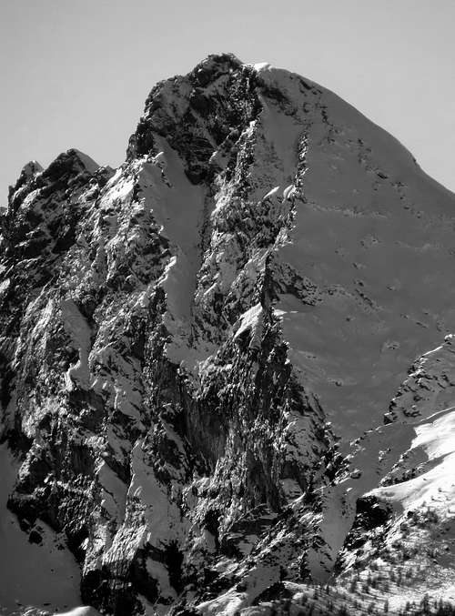
With North-northeastern View left/right: South Ridge, Est Wall, North Crest, North-northwest Face and West Edge; frontally in bottom the Belfrond Hill also called Hunters's Hill, by Antonio.
Piccola ma bella piramide, se osservata da Nord e da Nordovest, mentre da Oriente appare come torre squadrata e monca in punta lasciando cadere sulla sottostante Clavalité un'alta parete verticale, costituita però da roccia non buona (alcuni alpinisti di Fénis, quali Battista Pieller e la Guida Maurice Gaillard, vi ci hanno effettuato dei sondaggi, ma hanno dovuto rinunciarvi per questo motivo; informazioni private Gaillard-Pieiller; Anno 2000). Anche la frastagliata Cresta Sud, legantesi alla Grande Cresta "del Diavolo", può apparire da un'analisi dabbasso attraente ed affascinante per le sue bizzarre linee, ma anche per questa valgono le medesime considerazioni; sembrerebbe che alcuni bravi alpinisti abbiano provato a percorrerla rinunciando per la veramente cattiva qualità della roccia (Vedi Guida C.A.I. della Serie Monti d'Italia "Emilius Rosa dei Banchi Parco del M. Avic", di Giulio Berutto e Lino Fornelli, Edit. Marzo 2005, pagina 175). La stessa, mentre sul Versante Orientale "accompagna" le precipiti balze estreme della Parete Est, sul lato di Saint Marcel va a fondersi con la Parete Sudovest, che cade in direzione del Plan d'Emonin Dessus o Superiore; essa è formata da uno zoccolo basale di rocce più compatte, molto ripide e bluastre che, dopo un centinaio di metri, confluiscono in una grande faglia di frattura caratterizzata dalla sua forma ad arco rivolto in basso. Segue nella parte mediana un tratto svasato di rocce trite che confluiscono nella parte terminale, formata da rocce più ripide e sgretolate e di composizione similare a quelle dell'attigua Cresta Sud. Sul lato opposto della parete, un alquanto ripido Spigolo Sudovest sale direttamente e linearmente alla Vetta, dividendo questa da quella Ovest, rivolta maggiormente verso le due Alpi di Plan Rué. Per quanto concerne la Parete Ovest, la stessa scende con linee più "morbide" verso i sottostanti due Alpeggi di Plan Rué ed il Piano dell'Emonin; formata da due costole parallele delle quali la più Settentrionale forma uno spigolo con il Versante Nord-nordovest. Presenta un'arrampicata facile, veloce (nella prima ascensione fu percorsa in una sol ora dall'Alpe Plan Rué Desot) e divertente tramite una roccia rotta, ma abbastanza sicura. La Via Normale invece sale più a sinistra (Nord) ed al di là dello spigolo medesimo percorrendo il versante nel suo margine di sinistra ed appena sotto la linea spartiacque della Cresta Nord, tramite una salita facile, che richiede però una certa prudenza (vedi sotto la Route). Posizionata sulla costiera spartiacque tra le Valli di Saint Marcel, ad Occidente, e di Fénis-Clavalité ad Oriente è pure conosciuta in loco come Tita de la Rossa dal sottostante Tramouail (= Alpe) in questa ultima valle. Al contrario del vicino Mont Corquet alquanto frequentato e conosciuto per il suo percorso sci-alpinistico (vedi sempre in SP), è montagna scarsamente conosciuta ed ancora di meno frequentata dagli alpinisti, forse per il suo aspetto, tale da fare apparire la sua ascensione più difficile di quanto in effetti lo sia. Risulta così, nonostante le belle apparenze per l'insieme delle sue forme e linee, qual montagna ingiustamente negletta e quasi di "proprietà" degli alpinisti, cacciatori ed appassionati della montagna locali; sicuramente, salendola, non troverete né folla, né massa e neppure dovrete effettuare delle code per poter passare, facendo parte, per adesso, di quei luoghi che la Valle d'Aosta sa ancor offrire ed adatti a chi ama la solitudine, la Natura Selvaggia e possiede inoltre un affascinante desiderio d'esplorazione. Per la qual cosa ne consigliamo una gita ed inoltre per visitare le miniere di rame di Servette, di manganese di Praborna (= Prato della Buca) e di ferro della Riserva Turati (ex Riserva Naturale nonché di Caccia del Gressonaro Barone Beck Peck(c)oz), oltre alle meraviglie della flora (splendide ed eccezionalmente grandi stelle alpine nel canalone erboso-roccioso che sale verso il Colle Belfrond od altrimenti conosciuto qual Passo dei Cacciatori) e della fauna, ricca del Re Stambecco, di branchi di camosci, marmotte ed ogni altra creatura della Montagna, dominati dal regale volo dell'aquila, che spesso si vede transvolare, stagliandosi altissima nel cielo, sulla Catena della Grande Rouèze o Roise (= Grande Ghiacciaio, che non esiste quasi più del tutto, per la qual cosa deducesi essere il toponimo antichissimo; (3.357 m)) scavalcandola in direzione di Sua Maestà il Monte Emilius (3.559 m). Belle vedute sulla vicina Catena delle Roises verso Ovest, sulla Tersiva a Mezzogiorno, dalla quale trae origine il contrafforte che, formando per istrada, lungo la cresta spartiacque tra le Vallate di Saint Marcel/Fénis-Clavalité, la Punta del Tessonet, il Colle di Lavodilec, il Piccolo Avert, il Colle di Terre Blue, il Grand Avert, il Colle del Grand Avert, la Grande Cresta detta anche "Cresta del Diavolo", la Punta di Plan Rué, i Colli Belfrond e Crotey, il Mont Corquet, si esaurisce al Mont Roux, sopra la Valle della Dora Baltea e sugli alti pascoli delle Alpi Les Druges Alte e Basse. Inoltre verso Nord si aprono, qual grande ventaglio di oltre 180°, le Catene delle Alpi Graie Settentrionali e delle Pennine in una vista che sconfina dalla moli del Monte Bianco, del Mont Velan, del Grand Combin e del Gruppo del Mont Morion alle slanciate piramidi del Vallese, dalla Dents des Bouquetins (= Denti degli Stambecchi), alla Dent d'Hérin, dall'Obergabelhorn al Cervino o Matterhorn ai vastamente estesi ghiacciai del Monte Rosa, fin sul confine con la Regione Piemonte, nonché sulla lontana piramide "monca" e frastagliata della Punta Dufour che troneggia, ormai in Terra di Isvizzera. Più da vicino, e dirimpetto frontalmente verso Settentrione, si può ammirare il trittico di piramidi del Monte Faroma (a guisa di Gotica Cattedrale), della Becca del Luseney (dalla perfetta forma triangolare ed alquanto di moda tra gli alpinisti classici alla fine dell'800) e della Punta Cian (aguzza ed acuta come un brando), site tra la Valle Centrale e la selvaggia "Valle della Val Pelline".
From the Crotey Pass and from left: South Ridge, Est Wall, North Crest, North-northwest Face and West Edge; frontally in bottom the Belfrond Hill also called Hunters's Hill, by emilius.
First Ascents
First on the Summit: Unknown.
N Crest (Standard Route): Unknown.
In Winter: Unknown.
South Crest: Osvaldo Cardellina, lone, (May 04th, 2008), in day from Les Druges, Petite Chaux, Grand Avert Pass with crossing on Grande Cresta.
W Face (Left Ribbing): Osvaldo Cardellina, lone, (Aug 15th, 1992), in one hour from Plan Rué Low Alp.
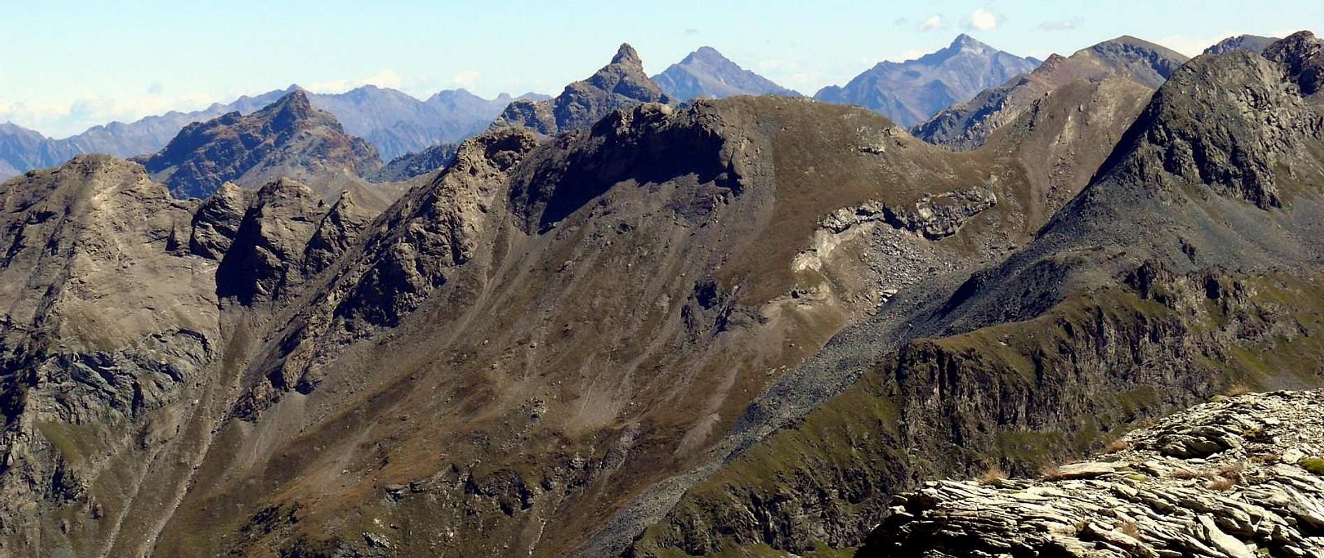
From Southerner View and from left: North Crest terminal part, North-northwest Face final part, West Face, Southwest Wall and South Crest to "Great Crest of The Devil" towards Great Avert Hill and Summit; in bottom the Midst of Saint Marcel Vallon, by Antonio.
Getting There
BY CAR:
From Torino, Milano, etc: Motorway A5. Exit Aosta est For Grand Brissogne and Saint Marcel.
From Switzerland: through the Grand St. Bernard Tunnel or the homonym Pass. Drive to Aosta, For Grand Brissogne and Saint Marcel.
From France: through Mont Blanc Tunnel or Petit St. Bernard Pass. It isn't necessary to enter in Motorway A5, you can drive through SS.26 Aosta direction. Exit Aosta est For Grand Brissogne and Saint Marcel.
SPECIFIC MAIN ROAD towards Saint's Marcel Valley: From the roundabout to the entry of the Country of Saint Marcel, to go up over on a wide bridge the River Dora Baltea, bringing himself in the center of the same in direction of his great Church; to edge it and to continue (manifold indications for which thing, with the purpose not to be wrong, to follow the poster of brown color with the wording "Sanctuary of Plout." To go up again toward South with the regional road in succession toward the Fractions of Crétaz (653m) and then, decidedly toward East, of Jayer (693m) and Mezein (793m); immediately after this point, leaving on the left a ramification that goes down to the Country of Fénis (prohibition of transit for the cars), the road changes completely direction toward Southwest to reach the Village of Réan (898m) and, through a long diagonal, the famous Sanctuary of Plout (898m; * splendid "Via Crucis" in the covered communication trench and before), where from centuries a procession happens departing really from Saint Marcel. Doubling it same the road is again addressed to thin East to a wide hairpin-road, where it reenters toward the preceding direction reaching the Village of Seissogne (1.066m) and, through great grasslands, the following one of Sazailland (1.220m); they follow those of Ronc (1.359m), Viplana (1.346m), Champremier (1.383m), over which he leaves on the left a deviation for the tall alpis of the Commune of Fénis (passable and open to the traffic) to reach the alternative for Porteron (famous for his international footstep of the sled) and the following place of Leycher (1.506m; famous "Inn of the Devil"). Returning to East, the road leaves in low the short deviation for Low Les Druges (1.567m) to reach later immediately to Tall Les Druges (1.600m around; beautiful fountain near a small square "rascard" in wood and votive tiny Chapel dedicated to Saint Bernard, at the beginning of the path n° 14 to Fontanafredda Pasture (1.810m).
STRADA REGIONALE SPECIFICA verso il Vallone di Saint Marcel: Dalla rotonda all'ingresso del Paese di Saint Marcel, scavalcare su di un largo ponte il Fiume Dora Baltea, portandosi nel centro dello stesso in direzione della sua grande Chiesa; contornarla e proseguire (molteplici indicazioni per la quale cosa, al fine di non sbagliare, seguire i cartelli di colore marrone con la dicitura "Santuario di Plout". Risalire verso Sud con la strada regionale in successione verso le Frazioni di Crétaz (653 m) e poi, decisamente verso Est, di Jayer (693 m) e Mezein (793 m); subito dopo questo punto, lasciando sulla sinistra una diramazione che scende al Paese di Fénis (divieto di transito per gli automezzi), la strada cambia completamente direzione verso Sudovest per raggiungere il Villaggio di Réan (898 m) e, tramite un lungo diagonale, il celebre Santuario di Plout (898 m; * splendida Via Crucis nel camminatoio ricoperto ed antistante), dove da secoli avviene una processione partendo proprio da Saint Marcel. Doppiando lo stesso la strada si indirizza nuovamente ad Oriente fino ad un largo tornante, dove rientra verso la precedente direzione raggiungendo il Villaggio di Seissogne (1.066 m) ed, attraverso grandi praterie, il successivo di Sazailland (1.220 m); seguono quelli di Ronc (1.359 m), Viplana (1.346 m), Champremier (1.383 m), oltre il quale si lascia sulla sinistra una deviazione per le alte alpi del Comune di Fénis (transitabile ed aperta al traffico) per raggiungere il bivio per Porteron (famosa per la sua pista internazionale dello slittino) e la successiva località di Leycher (1.506 m; rinomata "Locanda del Diavolo"). Ritornando ad Est, la strada lascia in basso la corta deviazione per Les Druges Basse (1.567 m) per pervenire subito dopo a Les Druges Alte (1.600 m circa; bella fontana presso un piccolo squadrato "rascard" in legno e Cappelletta votiva dedicata a San Bernardo, all'inizio del sentiero n° 14 per l'Alpeggio di Fontanafredda (1.810 m).
BY PLANE:
Aeroporto "Corrado Gex" Saint Christophe (Aosta).
Approachs toward the Saint Marcel Valley to Plan’s Rué Alps
From Saint Marcel and through the Pass of Leppe: from Tall Les Druges Village (1.567m; fountain and little beautiful wooden "rascard", nearby the same), place Pouria Alp (1.586m after the "Les Druges Picnic Area) along the coincident earth road "poderale" with the path n° 3 that, passing through Vargney Pasture (1.676m; various iron and copper dumpings of mine) and doubling from West to South the terminal rocky-woody promontory of Mont Roux (2.277m), it forwards him in the long Vallon of Saint Marcel, that arrives to homonym hill before the Cogne Valley. (* RESERVE of Hunting Marquis Turati and the Baron ex Reserve Beck Peck(c)oz) passing under the abandoned coppermines of Servette, among the 1.720 meters and the 1.810 meters. Beautiful turn tourist-excursion through paths n° 15/16, as well as different small paths of connection between the entrance of the various mines and huts in stone of the miners, protected from cyclopic great boundaries and supporting walls, and remains of great cableways. Wanting to effect complete to turn reconnaissance with different departures and slightly crossed to slighty more elevated quota;
a) - from the area PicNic with diagonal path that cuts to half coast the Northern slopes of Mont Roux reaching her same, from which with brief descent he returns on the earth road;
b) - departing from the near of the Alp Pouria (place "garages" in to beautiful clearing of lawns with demolished pasture, just immediately under the road; present system of signs as soon as awry near the small torrent) and reaching the first one dark or lower part and old hand the miners' installation, in downfall but with fireplace to standing wall still, for finally to connect him to the precedent itinerary. Besides possibility of prosecution and variation of excursion for the Alpe Lavanché (2.271m), with the path n° 18, along the forest, through the muletrack uses to the transport of the copper and iron minerals ones, with a characteristic passage on stony wall; from the same reenter to soil road through the small path n° 3 to crossroads 1836m, near Praborna Pasture (1.882m) and its manganesemine.
c) - With start after Vargney Alp (1.676m), through, always, path n° 18, crossing in parallel with a small brook of irrigation and inside a good and thick forest, reaching the previous routes. To continue South direction, crossing at the foots of Westerner Slope of Mount Roux traversing the its woods, to (* * Hunting's House Turati of Mulac (1.937m; beautiful fountain and statuary steinbock, both in wood; entrance of mines, also them abandon, of manganese near Praborna Pasture (= Lawn of the Hole; 1.882m; rarities of the "violano", mineral existing in few places in the world; to enter with small deviation on road not numbered, over the alternative 1.836m and small final diagonal). From the aforesaid crossroads, where the path on the left (East) the deviation for the Alp Lavanché the same very small path with numeration 3, to continue with the soil "poderale" road-path n° 4; the same one, formed a great handle after the bridge in wood preceding the Sinsein Pasture (1.995m) and, through a steep line goes up again rather, after having forded two other secondary torrents, toward the Alps Dessous of Plan Ruè (2.100m and 2.129m).
Da Saint Marcel e tramite il Col di Leppe: da Les Druges Alta (1.567 m; fontanile e splendido piccolo "rascard" in legno appresso la medesima), località Pouria (1.586 m) lungo la poderale coincidente con il sentiero n° 3 che, doppiato il roccioso e boschivo promontorio terminale del Mont Roux (2.277 m), si inoltra nel lungo Vallone di Saint Marcel, che perviene sino all'omonimo colle a cavallo con la Valle di Cogne. ( * RISERVA di Caccia Marchese Turati ed ex riserva del Barone Beck Peck(c)oz; passando al di sotto delle miniere abbandonate di rame di Servette tra i 1.720 metri ed i 1.810. Bel giro turistico-escursionistico tramite sentieri n° 15/16, nonché diversi sentierucoli di collegamento tra l'imbocco delle varie miniere, resti di grandi teleferiche e baracche in pietra dei minatori, protette da ciclopici muraglioni di cinta, nonché di sostegno. Volendo effettuare un giro perlustrativo più completo, con partenze diverse, ed attraversata a quota leggermente più elevata:
a) - dall'Area Pic Nic con sentiero diagonale, che taglia a mezzacosta i versanti Settentrionali del Mont Roux, raggiungendo le miniere stesse, dalle quali con breve discesa si ritorna sulla strada poderale;
b) - partendo dai pressi dell'Alpe Pouria (località "garages" in una bella radura prativa con alpe diroccata, subito sotto la strada; segnaletica presente appena a monte, presso il torrentello) e raggiungendo il primo o più basso e vecchio insediamento dei minatori, in rovina ma con camino a muro ancora in piedi, per infine ricollegarsi al precedente itinerario. Inoltre possibilità di prosecuzione per l'Alpe Lavanché (2.271 m) con sentiero n° 18, lungo la foresta per mezzo della mulattiera usa al traporto dei minerali del ferro e del rame, con un caratteristico passaggio su di un muraglione di pietra; dall'alpeggio rientrare sulla poderale per mezzo del sentierino n° 3 in direzione dell'incrocio 1.836 m, nei pressi dell'Alpe di Praborna (1.882 m) e della sua miniera di manganese.
c) - Con avvio dalla poderale oltre l'Alpeggio di Vargney (1.676 m), tramite sentiero n° 18, parallelamente ad un ruscelletto d'irrigazione nel fitto della bella foresta e così pervenendo ai precedenti itinerari. pervenendo, passando ai piedi del versante Occidentale del Mont Roux ed attraversandone i suoi boschi, alla (* * Casa di Caccia Turati a Mulac (1.937 m; bel fontanile e statuario stambecco, entrambi in legno); imbocco delle miniere, anch'esse abbandonate, di manganese a Praborna (= Prato della Buca); 1.882 m; rarità del violano, minerale esistente in pochi posti nel mondo; per accedervi piccola deviazione su strada poderale non numerata, oltre il bivio 1.836 m e breve diagonale finale. Dall'incrocio predetto, ove il sentiero lasciata sulla sinistra (E) la deviazione per l'Alpe Lavanché tramite il medesimo sentierino con numerazione 3, continuare con la strada poderale sentiero n° 4; la medesima, formata una grande ansa dopo il ponte in legno prededente l'Alpe di Sinsein (1.995 m), e, per mezzo di un tratto alquanto ripido, risale, dopo aver guadato due altri torrenti secondari, verso gli Alpeggi Dessous di Plan Ruè (2.100 m e 2.129 m).
Route
From the dirt road "poderale" path n° 4 to abandon the last among the two Pastures of Plan Rué to take to decidedly climb toward East, addressing himself to a small grassy channel and debris (very beautiful and gigantic alpine stars), that goes up again, in the middle of two small torrents-brooks, in the Summer almost entirely buckets, with a good inclination in direction of the Collar Belfrond (2.598m; known and frequented almost exclusively by the hunters and with this placename known from the same), immediately to North of the same point. Hundred meters before reaching, to turn him more toward Southeast and to climb for rocks with grass and deposits, formed by thin flakes, up to almost reach on the thread of the Crest North, watershed dividing and separating the Valley of Saint Marcel from this of Fénis-Clavalité; not to go himself on the same one, on the contrary, mostly holding himself on the left (East), to climb for the narrow and triangular Slope North-northwest between the crest and the steep and rocky Ribbing of Left of the West Wall. With the same characteristics to go up again it with the inclination that progressively goes increasing and on terrestrial not difficult, but surely untrustworthy (above all if frozen), that it asks for attention and caution for the notable gravel that almost entirely covers the rock. In the last line to mostly support on the left, reaching the terminal part of the Northern Crest, whereas this in practice goes to melt himself with the West Edge, and with this, through a less steep and brief final line, to reach the Peak, on which in a small niche to the Summit of the East Wall, here with a cliff with a sheer drop to the morains impending the pastures of La Rossa Tramouail or Alp, is "hidden" a little and tiny Statue of the Madonna (>EE/A; F+; 1h'00/1h'15 from the Alps of Plan Rué; 2h'30/3h'00 from the poster of prohibition after the area Pic Nic of Tall Les Druges little Village).
Dalla strada sterrata "poderale" sentiero n° 4 abbandonare quest'ultimo tra le due Alpi di Plan Rué prendere a salire decisamente verso Oriente, indirizzandosi ad un piccolo canale erboso e detritico (stelle alpine bellissime e gigantesche), che risale, in mezzo a due torrentelli, in Estate quasi del tutto secchi, con una buona pendenza in direzione del Colletto Belfrond (2.598 m; conosciuto e frequentato quasi esclusivamente dai cacciatori e con questo nome riconosciuto tra i medesimi), subito a Settentrione della punta medesima. Un centinaio di metri prima di raggiungerlo, girare più verso Sudest e salire per rocce con erba e detriti, formati da sottili scaglie, fino a pervenire quasi sul filo della Cresta Nord, spartiacque divisorio che separa la la Valle di Saint Marcel da quella di Fénis-Clavalité; non portarsi sulla stessa, bensì salire, tenendosi maggiormente sulla sinistra (Est), per lo stretto e triangolare Versante Nord-nordovest tra la cresta e la più ripida e rocciosa Nervatura di Sinistra della Parete Ovest. Con le stesse caratteristiche risalirla con la pendenza che va progressivamente aumentando e su terreno non difficile, ma sicuramente infido (soprattutto qualora fosse gelato), che richiede attenzione e precauzione per la notevole ghiaia che ricopre quasi completamente la roccia. Nell'ultimo tratto appoggiare maggiormente sulla sinistra, raggiungendo la parte terminale della Cresta Nord, laddove questa in pratica va a fondersi con lo Spigolo Ovest, e con questa, tramite un breve tratto finale meno ripido, raggiungere la Vetta, sulla quale in una piccola nicchia al culmine della Parete Est, qui strapiombante sulle morene soprastanti i pascoli del Tramouail dell'Alpeggio La Rossa, è "nascosta" una Statuina della Madonna (EE/A; F+; 1h'00/1h'15 dalle Alpi di Plan Rué; 2h'30/3h'00 dal cartello di divieto dopo l'Area Pic Nic del Villaggetto di Les Druges Alte).
Difficulty
For EE/A or Expert Excursionists or Mountaineers, as from U.I.A.A.
Per EE/A Escursionisti Esperti oppure Alpinisti, come da normative U.I.A.A.
Campings
Remember that free camping is forbidden (except for emergency reasons, over 2.500m, from darkness until dawn).
Equipment
Standard mountaineering equipment.
Da escursionismo.
Mountain Condition
You can get meteo information at the official site of the Regione Valle d'Aosta:
"Guida dei Monti d'Italia – Emilius Rosa dei Banchi-Parco del Mont Avic" di Giulio Berutto e Lino Fornelli - Club Alpino Italiano/Touring Club Italiano, Marzo 2005.
"Diari Alpinistici" di Osvaldo Cardellina e Indice Generale accompagnato da Schedario Relazioni Ascensioni 1964-2019 (inediti).
MAPS:
Kompass "Gran Paradiso Valle d'Aosta Sentieri e Rifugi" Carta Turistica 1:50.000.
L'Escursionista "Tour de la Vallée de Cogne Grand Paradis" Carta dei sentieri 1:25.000.
Hapax "Les Sentiers" Comunità Montana Monte Emilius, Luglio 2000 1:25.000.
Enrico Editore Ivrea-Aosta "Gruppo del Gran Paradiso" 1:50.000.
L'Escursionista "Valle di Cogne" Carta dei Sentieri 1:25.000.
Parents refers to a larger category under which an object falls. For example, theAconcagua mountain page has the 'Aconcagua Group' and the 'Seven Summits' asparents and is a parent itself to many routes, photos, and Trip Reports.

 7103 Hits
 84.27% Score
 18 Votes