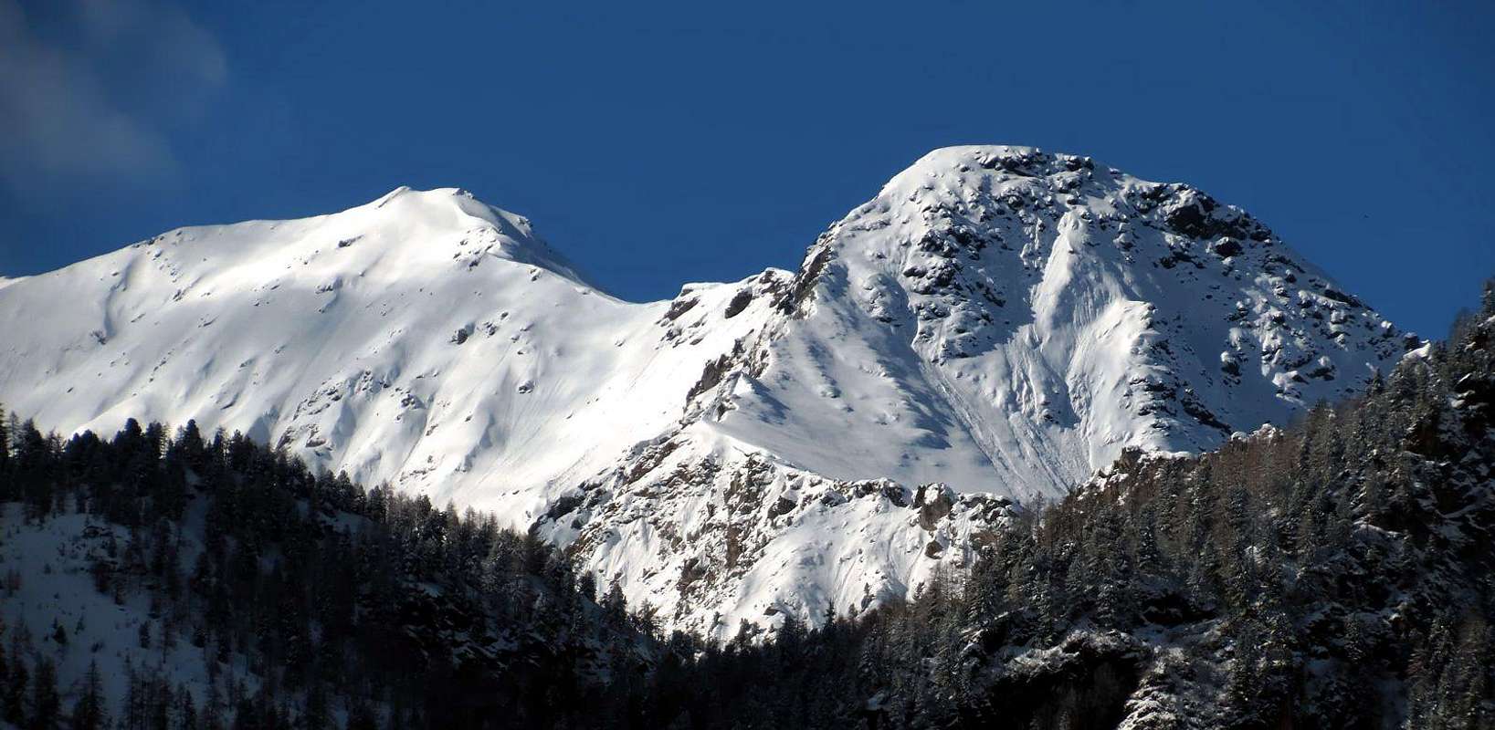
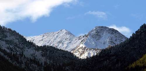
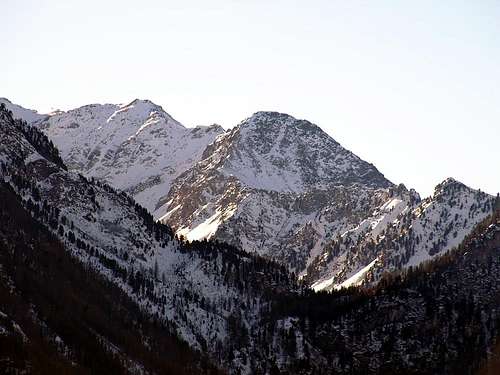
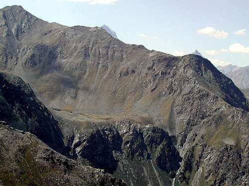
Formerly known as Auille Nera, from the Lake of Chamolé (2.311m) it looks like a solid and compact grey big head with a wide and bowl liking summit. A metallic cross, well visible from below, is placed on its top. Its steepest side is the northern one that, ending with a broken rocks short wall, falls down on the talus in front of the lake. Its Summit is very often climbed for its extraordinary panoramic views on the Grivola, Monte Emilius, Garin and the near ranges of Pennine and Graie Alps. This mountain is composed of three ridges with as many fronts: in addition to the first of what we have said, the other two go down to the East over the Vallon of Arbolle (2.500m) consists of steep cliffs interspersed with layers of grass and from the Plan de l'Eyve (2.352m) in the opposite direction. The ridges, three in number, are directed to the South connecting the mountains with Mont Bellefaçe (2.970m), in the Northeast over the Chamolé Pass (2.641m) and to the Northwest in the direction of the Station of arrival of Chairlift Stack Chamolé (2.311m). Along the last two crests rise the two "Normal Routes", generally covered; the first salt from Lake Chamolé (2.325m) to the said hill to then proceed below the ridge on which returns in the final part, while the second or "Via degli Alpini" salt under the Northwest Crest but definitely more shifted towards the less steep Slope Northwest. On the same street had been equipped with a number of ropes, which is not necessary as the easy route and little exposure except in some short sections, which over time have been ruined or simply removed. This route is safer than that rises from Chamolé, though less popular, however, because it is less known and off the route that leads to the Refuge of Arbolle (2.516m). They are generally covered both with the one that goes from Chamolé reported as via the nearby Punta della Valletta (3.090m). One must keep in mind that during the winter, in the presence of excessive snow, both climbs become somewhat dangerous; in fact, on the Northwest Slope down a regular avalanche, which struck above the underlying ski slopes, while on the opposite side of the danger comes from the descent into the below Arbolle Walloon. In fact in the first section, immediately below the hill, it is very easy to cause the detachment of the same. Beautiful views of almost the entire Valley of Aosta, only limited to the East by the trio of pyramids Monte Emilius, Punta Rossa and Pic Garin, while to the South the view is obstructed by the Punta della Valletta. Great quick glances, however, on the nearby Grivola.
Appare alla vista dal Lago di Chamolé (2.311 m) come un massiccio e compatto testone grigiastro; dalla cima ampia e a forma di conca. In vetta si trova una croce metallica ben visibile dal basso. Dei suoi versanti il più scosceso è quello settentrionale che con una paretina di rocce rotte va a cadere sulla pietraia antistante il lago. La cima è molto frequentata a scopo panoramico con viste eccezionali sulla Grivola, Emilius, Garin e sulle Alpi Graie e Pennine. Anticamente era anche conosciuta come Auille Nera. Questa montagna é formata da tre creste con altrettanti versanti: oltre al primo del quale abbiamo detto, altri due scendono verso Oriente al di sopra del Vallone di Arbolle (2.500 m) composto da ripide rocce frammiste a strati erbosi e verso il Plan de l'Eyve (2.532 m) nell'opposta direzione. Le creste, in numero di tre, sono rivolte a Sud collegando la montagna con il Mont Bellefaçe (2.970 m), a Nordest sopra il Colle di Chamolé (2.641 m) ed a Nordovest in direzione della Stazione di arrivo della Seggiovia Pila Chamolé (2.311 m). Lungo le ultime due creste salgono le due "Vie Normali", generalmente percorse; la prima sale dal Lago di Chamolé (2.325 m) al suddetto colle per poi procedere sotto la cresta sulla quale ritorna nella parte finale, mentre la seconda o "Via degli Alpini" sale sotto la Cresta Nordovest ma decisamente più spostata verso il meno ripido Versante Nordovest. Sulla medesima era stata attrezzata una via con alcune corde, peraltro non necessarie essendo il percorso facile e poco esposto se non in alcuni brevi tratti, che nel tempo sono andate in rovina oppure semplicemente asportate. Questo itinerario é più sicuro di quello che sale dal Colle di Chamolé, anche se però meno frequentato perché meno conosciuto e fuori dalla rotta che conduce al Rifugio di Arbolle (2.516 m). In genere vengono percorse entrambe con quella che sale dal Colle di Chamolé segnalata come via per la vicina Punta della Valletta (3.090 m). Bisogna tenere ben presente che durante lo inverno, in presenza di eccessiva neve, entrambe le salite diventano alquanto pericolose; infatti sul Versante Nordovest scende regolarmente una valanga che si abbatte sopra le sottostanti piste di sci, mentre sul lato opposto il pericolo viene dalla discesa verso il Vallone di Arbolle. Infatti nel primo tratto, subito al di sotto del colle, risulta molto facile provocare il distacco della medesima. Belle viste su quasi tutta la Valle di Aosta, soltanto limitate ad Est dal trio di piramidi Monte Emilius, Punta Rossa e Pic Garin, mentre a Sud il panorama é occluso dalla Punta della Valletta. Grandi colpi d'occhio, comunque, sulla vicina Grivola.
First ascents
First on the summit: Unknown.
First in winter: Osvaldo Cardellina, Corrado Covi, Edy Covi, Camillo Roberto Ferronato, Giuseppe Lamazzi and Armando Poli, (Dec 30th, 1977).
NE Crest (Standard Route): Unknown.
N Wall (left route): Amilcare Crétier and Lucine Salval, (1925).
N Wall (central route): Osvaldo Cardellina and Dario Sergio Cardellina, (Jul 29th, 1966).
N Wall (right route): Osvaldo Cardellina and Ilario Antonio Garzotto, (Sep 22th, 1967).
N Wall (extreme right route) and NW Ridge: Osvaldo Cardellina, lone (Aug 31th, 2004).
NW Ridge: Ilario Antonio Garzotto and Osvaldo Cardellina, (May 27th, 1967).
Getting There
BY CAR:
From Torino, Milano, etc: Motorway A5. Exit at Aosta Est.
From Switzerland: through the Grand Saint Bernard Tunnel or the namesake Pass.
From France: through Mont Blanc Tunnel or Petit Saint Bernard Pass. It isn't necessary to take Motorway A5: you can drive on SS.26, in the direction of Aosta.
BY PLANE:
Aeroporto "Corrado Gex"; Saint Christophe (Aosta).
Approaches
Approach A from Pila Resort: (2.325m) on foot through the various paths n° 19/19A/19B, passing respectively to the Alpage of Chamolé (2.532m; fountain), also towards the Bois (Wood) Chanté, going up directly into a small walloon to Chamolé Lake (2.325m). Or by a chairlift, and the homonymous pass above (2.641m). Wherefrom the Normal Route (Northeast Crest) starts also from the ones arriving here from Arbolle.
Avvicinamento A dal Comprensorio di Pila: Da Pila (nota località sciistica, raggiungibile da Aosta in auto pullman o funivia), raggiungere il Lago di Chamolé (2.325 m, anche qui in seggiovia o a piedi tramite i vari sentieri n° 19/19A/19B) che passano rispettivamente per l'Alpe di Chamolé (2.532 m; fontana), oppure attraverso il Bois Chanté, salendo direttamente tramite un valloncello al Lago di Chamolé (2.325 m) e l'omonimo colle superiore (2.641 m). Da qui inizia la Via Normale (Cresta Nordest) anche per chi perviene da Arbolle.
Approach B Arbolle Refuge: from the hut (2.516m, reachable from the Cogne Valley starting from Gimillan Hamlet (1.787m) through the Vallon of Arpisson, the Bivouac Franco Nebbia (2.740m) and the Garin Hill (2.815m) through the trails n° 2 and down in the Vallon of Arbolle through n° 18) ford the torrent in a small cove at the old barn and started to go up with large bends between grassy slopes through the path n°18/TVC; with a diagonal progressively towards the North and a steep section at the terminal easily and quickly you get to Chamolé, whence the Northeast Ridge (T/E; 0h'30).
Avvicinamento B dal Rifugio di Arbolle: dal rifugio (2.516 m; raggiungibile anche dalla Valle di Cogne con partenza dal Villaggio di Gimillan (1.787 m) tramite il Vallone di Arpisson, il Bivacco Franco Nebbia (2.740 m) ed il Colle Garin (2.815 m) tramite i sentieri n° 2 ed in discesa nel Vallone di Arbolle n° 18) guadare il torrente in una piccola ansa presso la vecchia stalla ed iniziare a salite con larghi tornanti tra pendii prativi tramite il sentiero-mulattiera n° 18/TVC; con un diagonale progressivamente verso Nord ed un tratto più ripido nella parte terminale facilmente ed in breve tempo si arriva al Colle di Chamolé, donde alla Cresta Nordest (T/E; 0h'30).
Approach C from the Vallon of Comboé: by Comboé (2.114m; private retreat of the Canons of Saint Orso, reachable by Ponteilles or stack via the Plan Fenêtre Hill) you can reach the Chamolé with two other possibilities:
1) - immediately behind the shelter apart from the steep path n° 19 rather than through hairpin bends to reach the North Col Replan (2.366m); from this a wider path down to the Southwest towards Lake Chamolé (yellow signs) where you reconnect with the previous Approach A.
2) - it is also possible to reach the Refuge Arbolle with a larger circle to the South that, after reaching the Alp derelict Grand Plan (2.158m), crosses the Torrent de Comboé with a diagonal from right to left in the middle of a heap of stones; the route n° 16 at this point enters a narrow gorge with very tight bends reaches him, hence the Approach B (calculated both from 1h'30 to 1h'45 to the hill).
Avvicinamento C dal Vallone di Comboé: da Comboé (2.114 m; rifugio privato dei Canonici di Sant'Orso, raggiungibile da Ponteilles o da Pila tramite il Colle Plan Fenêtre) si può raggiungere il Colle di Chamolé con due altre possibilità:
1) - da subito dietro il rifugio parte il ripido sentiero n° 19 che, tramite alquanto stretti tornanti, raggiunge il Colle Settentrionale di Replan (2.366 m); da questo un sentiero più largo scende a Sudovest verso il Lago di Chamolé (indicazioni in giallo) dove ci si riconnette col precedente Avvicinamento A.
2) - Inoltre é possibile raggiungere il Rifugio d'Arbolle con un giro più largo verso Sud che, dopo aver raggiunto l'Alpe diroccata di Grand Plan (2.158 m), attraversa il Torrent de Comboé con un diagonale da destra verso sinistra in mezzo ad una pietraia; il sentiero n° 16 a questo punto entra in una stretta gola e con tornanti strettissimi lo raggiunge, donde allo Avvicinamento B (calcolare per entrambi da 1h'30 a 1h'45 al colle).
Routes
Via A climb with "traditional route" through Chamolé Pass and the Northeast Crest: This is definitely the way followed by more and more, but still something extra after the construction of the Shelter Arbolle in July 1998. Starting with the arrival of the Chair (2.311m) to quickly reach a wide path through the slight slope Chamolé Lake (2.325m ; yellow signs); from the junction with the trail to the Hills of Replan and Comboé Vallon climb down to the right (South) and with a long diagonal first, followed by numerous large hairpin bends, reach Chamolé Pass (2.641m; 0h'50), real door entrance to the Vallon of Arbolle, lakes and shelter. Always a yellow sign points the way to the Tip of the Valletta (+ 3.090m) on the right; follow these directions and on a small track begin the ascent to below the edge of the Northeast Crest (this can be traversed in steps of I°/II°, exposed to Southeast) until the same, via a short crossing, is port more on the Northeast Slope. Go up broken rocks and debris and then with a few small steps on some narrow arrive on the same ridge where the trail becomes more evident with exposure from the same side; in short it out on the vast grassy plateau immediately to the left of the Cross of Summit (E/F; 0h'30; total 1h'30 from the start; 3h'00/3h'30 from Pila).
Via A con salita "tradizionale" tramite il Colle di Chamolé e la Cresta Nordest: si tratta sicuramente della via maggiormente seguita da sempre, ma ancor più dopo la costruzione del Rifugio di Arbolle nel Luglio 1998. Partendo dall'arrivo della Seggiovia (2.311 m) raggiungere in breve tempo tramite un largo sentiero in falsopiano il Lago di Chamolé (2.325 m; cartelli segnaletici gialli); dal bivio con il sentiero per i Colli di Replan ed il Comboé salire invece a destra (Sud) e con un primo lungo diagonale, seguito da numerosi e larghi tornanti, raggiungere il Colle di Chamolé (2.641 m; 0h'50), vera porta d'ingresso per il Vallone di Arbolle, laghi e rifugio. Un cartello sempre giallo indica la via per la Punta della Valletta (+ 3.090 m) sulla destra; seguire queste indicazioni e su d'una piccola traccia iniziare la salita al di sotto del filo della cresta Nordest (questa può essere percorsa con passaggi di I°/II°, esposti a Sudest) fino a quando le stesse, tramite una breve traversata, si portano maggiormente sul Versante Nordest. Salire per rocce rotte e detriti per poi con alcuni passaggetti su alcune strettoie arrivare sulla cresta medesima, ove il sentiero diventa più evidente con esposizione sempre identica; in breve si esce sul vasto plateau erboso subito a sinistra della Croce della Sommità (E/F; 0h'30; in totale 1h'30; 3h'00/3h'30 da Pila).
Route B along the small Northern Face: The grassy North-northeast Side of the mountain is divided, by a steep rib of broken rocks, from a steep short (little more than 280 meters of difference in elevation) Northern Wall. Starting from the lake you have to ascend along the scree slope leading to the base of the face; climb a slab under a bow ledge then go to the left (East) along it to arrive to the edge of the rib, now straight to the Summit, with amusing climbing. On the same face there are other routes that cross the field to the right, the center couloir, ranging from basic and final way, and the first to be built by the famous Amilcare Crétier with Lucine Salval in the summer of 1925, rising to the East of the small pillar central, almost on the North Side to Northeast. Finally, then traverse to the right on the same with which it is concluded (EE/A; da F+ a PD+, depending on the chosen route; from 2h'15 to 3h'00).
Via B con salita per la Paretina Nord: Il versante erboso Nord-nordest è separato per mezzo di una ripida costola di rocce rotte da una paretina rivolta più a Nord, alta poco più di 280 metri. Dal lago salire la ripida pietraia che porta alla base della parete; attaccare per una placca sottostante una cengia ad arco e percorrerla verso sinistra (Est) prendendo il filo dello sperone che direttamente con passaggi divertenti, porta alla Vetta. Sulla medesima parete esistono altre vie che percorrono il settore di destra, il canale centrale, alcune varianti di base ed un'ultima via, la prima ad essere stata realizzata dal famoso Amilcare Crétier con Lucine Salval nell'estate del 1925, che sale ad Est del pilastrino centrale, quasi sul Versante Nord-nordest. Infine, per poi attraversare e concludere per mezzo dello stesso (EE/A; da F+ a PD+, a seconda della via scelta; da 2h'15 a 3h'00).
Route C rise for the Northwest Slope ("Via degli Alpini") or to the Northwest Ridge: a third way, an alternative to A, up along the Northwest Slope, just below the crest of the same, that goes on the left. Always starting from the Station of Chair lift, climb directly to the South through a small and very steep path numbered 19B, which reaches a rocky headland forest-followed by a depression (2.450m); reach a second altitude (2.484m) neighbor a structure of the lifts of white color. From this point the trail, which is getting smaller and subsequently less obvious moves away from the ridge into the Northwest bringing more open slope until you reach a large grassy saddle South of the Summit. With this and with the direction to the North in a short time you can reach the same (E/F; 1h'15/1h'30 Station; 3h'00/3h'15 from Pila Resort). Alternatively, if you want to climb, carry much of the property on the Northwest Edge of the ridge and follow the same steps with the possibility of changing to a plate blackish just just below the Top; go with fun climbing (III°/III°+), or around the same immediately below to South (from F+ to AD-, according to the passages performed; from 2h'00 to 2h'30 from the arrival of Station).
Via C con salita per il Versante Nordovest ("Via degli Alpini") o per la Cresta Nordovest: una terza via, alternativa alla A, sale lungo il Versante Nordovest, subito al di sotto della identica cresta, che la accompagna sulla sinistra. Sempre partendo dalla Stazione della Seggiovia, si sale direttamente verso Mezzogiorno tramite un piccolo ed alquanto ripido sentiero numerato 19B, che raggiunge un promontorio boschivo-roccioso seguito da un avvallamento (2.450 m); raggiungere un secondo in altitudine 2.484 m) presso una struttura degli impianti da sci di colore bianco. Da questo punto il sentiero, che diventa sempre più piccolo ed in seguito meno evidente, si allontana dalla Cresta Nordovest portandosi in più aperto pendio fino a raggiungere una vasta sella erbosa a Sud della Sommità. Tramite questo e con direzione a Nord in breve tempo si raggiunge la medesima (E/F; 1h'15/1h'30 dalla Stazione; 3h'00/3h'15 dal parcheggio di Pila). In alternativa, volendo arrampicare, dalla struttura portarsi decisamente sul filo della Cresta Nordovest e seguire lo stesso con possibilità di variare i passaggi fino ad una placca nerastra appena subito sotto la Sommità; salire con divertente arrampicata (III°/III°+), oppure aggirare la medesima subito al di sotto a Sud (da F+ a AD-, a seconda dei passaggi eseguiti; da 2h'00 a 2h'30 dall'arrivo della Seggiovia).
Equipment for the Route
Standard mountaineering equipment.
Difficulty
Normal Routes: Easy anf for Experienced Hikers F.
N Wall: PD+ (low difficult) passages of I - II and II+ (UIAA).
L'itinerario delle Via normali è da considerarsi F/EE.
Per la Parete Nord PD+ passaggi di I – II – II+.
Campings
Remember that free camping is forbidden (except for emergency reasons, over 2.500m, from darkness until dawn).
Mountain Condition
Meteo: you can find all the needed informations at the official site of the Valle d'Aosta Region:
"Guida del Monte Emilius", di Osvaldo Cardellina Editore in collaborazione con il Club Alpino Italiano Sezione di Aosta, Dicembre 1978.
"Guida dei Monti d'Italia – Emilius Rosa dei Banchi Parco del Mont Avic" di Giulio Berutto e Lino Fornelli - Club Alpino Italiano/Touring Club Italiano, Marzo 2005.
"Guida delle Alpi Occidentali" di Giovanni Bobba e Luigi Vaccarone C.A.I. Sezione di Torino Volume II (parte II), 25 Maggio 1896.
"80 itinerari di Escursionismo Alpinismo e Sci Alpinismo in Valle d'Aosta", di Osvaldo Cardellina, Ed. Musumeci, Giugno 1977 (in Italian); seconda Ed. Luglio 1981; terza Ed. Luglio 1984; (in French), prima Ed. Febbraio 1978; seconda Ed. Marzo 1980.
"Diari Alpinistici" di Osvaldo Cardellina e Indice Generale accompagnato da Schedario Relazioni Ascensioni 1964-2019 (inediti).
MAPS:
Kompass "Gran Paradiso Valle d'Aosta Sentieri e Rifugi" Carta turistica 1:50.000.
L'Escursionista "Conca di Aosta-Pila-Monte Emilius" Carta dei sentieri (n° 4) 1:25.000.
Hapax "Les Sentiers Comunità Montana Monte Emilius", Luglio 2000 1:25.000.
Enrico Editore Ivrea-Aosta "Gruppo del Gran Paradiso" 1:50.000.
I.G.C. Istituto Geografico Centrale, Torino "Carta delle Passeggiate ed Escursioni in V.D.A. Conca di Pila-Gressan, 1:20.000.
Children refers to the set of objects that logically fall under a given object. For example, the
Aconcagua mountain page is a child of the 'Aconcagua Group' and the 'Seven Summits.' The
Aconcagua mountain itself has many routes, photos, and trip reports as children.
Parents refers to a larger category under which an object falls. For example, theAconcagua mountain page has the 'Aconcagua Group' and the 'Seven Summits' asparents and is a parent itself to many routes, photos, and Trip Reports.

 9682 Hits
 89.77% Score
 30 Votes