Hiking, Mountaineering, Trad Climbing, Sport Climbing, Toprope, Bouldering, Ice Climbing, Aid Climbing, Big Wall, Mixed, Scrambling, Via Ferrata, Canyoneering, Skiing
La montagna chiama i suoi figli, ed essi rispondono fedelmente al suo appello…
Osvaldo Cardellina, Diario alpinistico, 1964-65
Page texts: @ OsvaldoCardellina"Osva", passed away on May 2, 2022. Page owners: Christian Cardellina e Osvaldo Cardellina. Any updates from September 12, 2022: Antonio Giani, page administrator, friend and climbing companion.
Testi della pagina: @ OsvaldoCardellina "Osva", scomparso il 2 maggio 2022. Proprietari pagina:Christian Cardellina e Osvaldo Cardellina. Eventuali aggiornamenti dal 12 settembre 2022: Antonio Giani, amministratore della pagina, amico e compagno di salite.
Rhêmes Rhêmes Overview
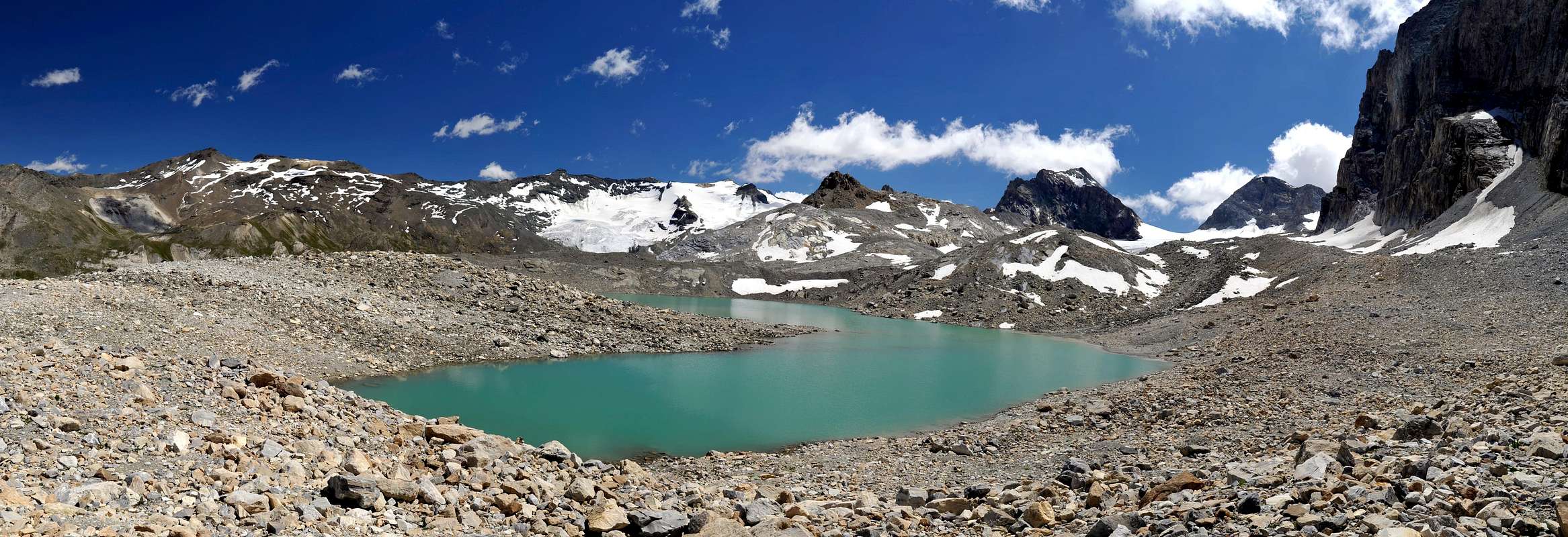
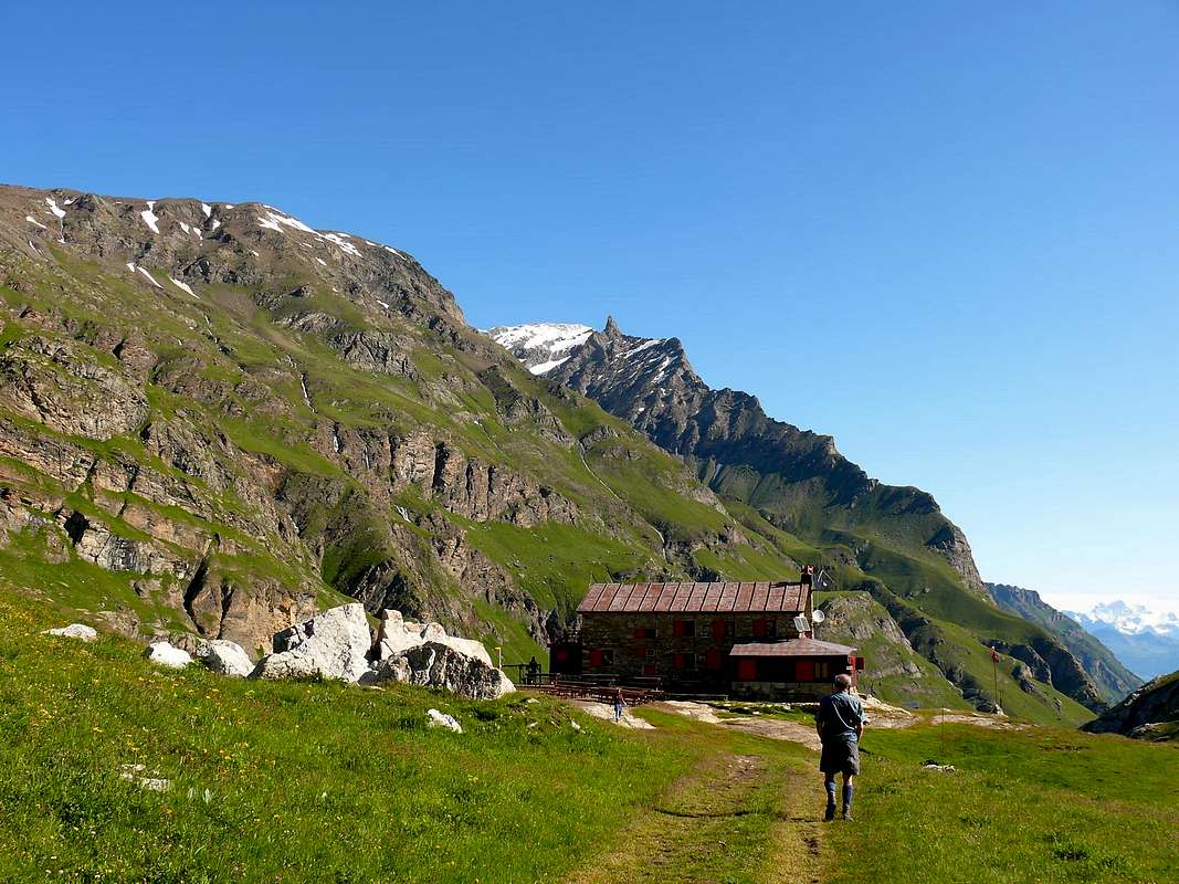
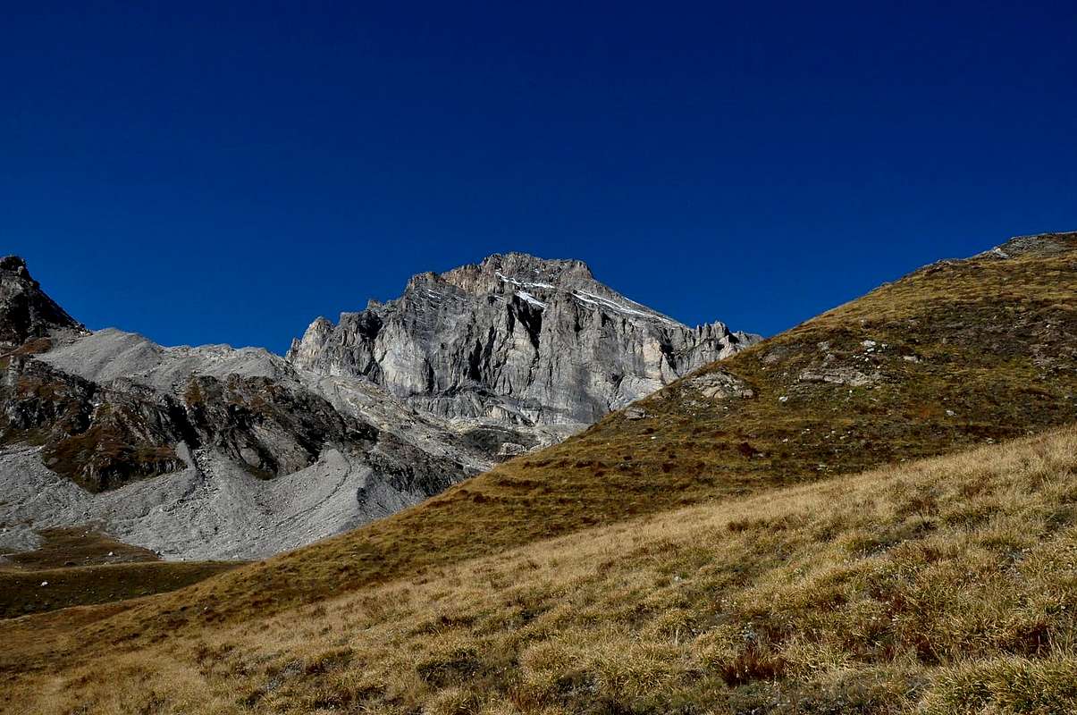
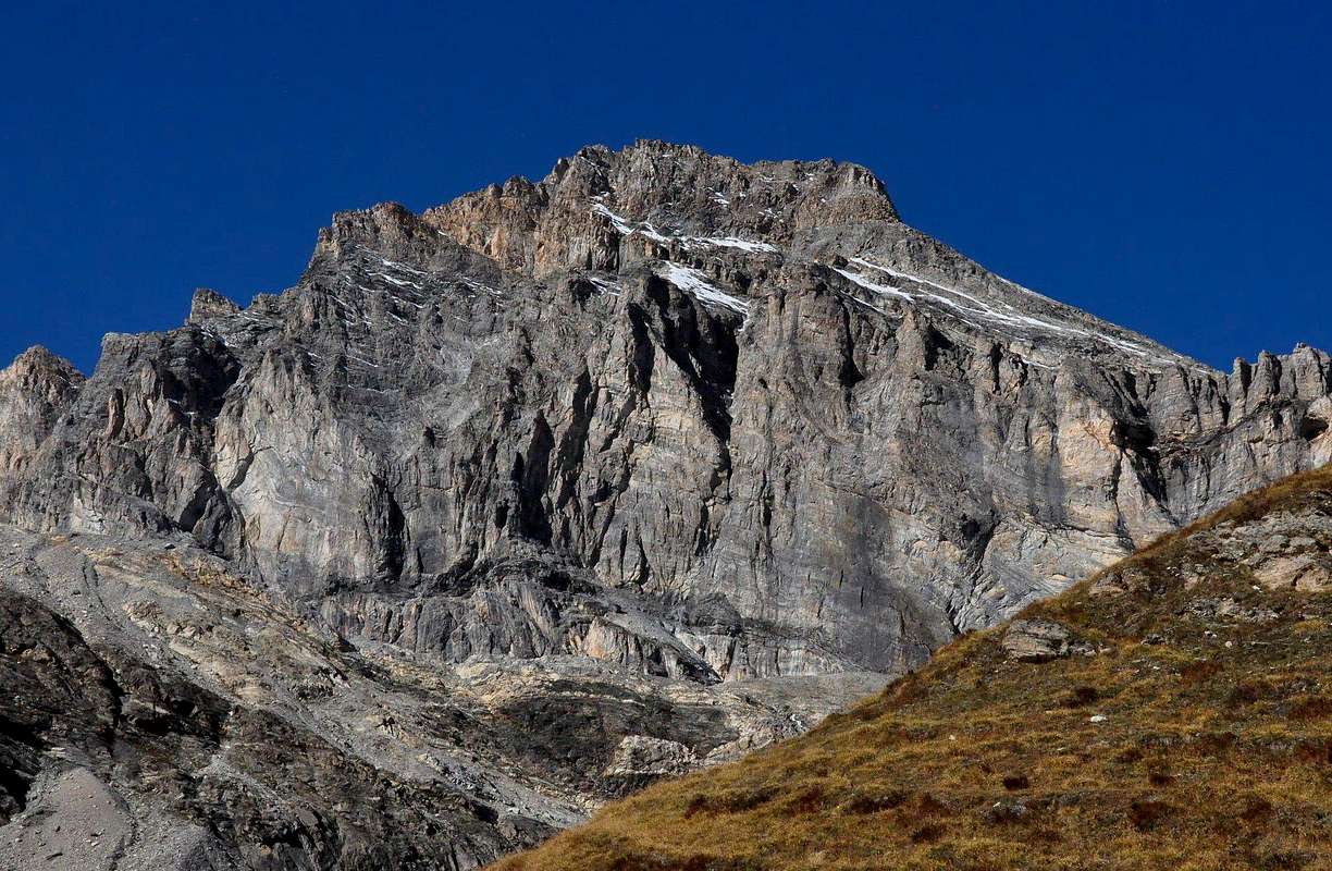
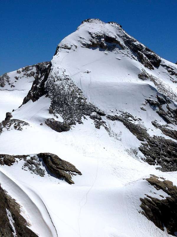
Rhêmes Valley: this valley is located between those of Valsavarenche (East) and Valgrisenche. Over 28 Kilometres long and wide from four to seven takes start from the junction on Regional Road after the Municipality of Villeneuve and just after the next to of Introd, neighbor the Village of Tache Buillet. The bifurcation of the left (Southeast) is directed towards the Valsavarenche, the other towards the Valley of Rhêmes reaching not long after the Municipality of Rhêmes Saint Georges (1.171m), more probably the smallest of the entire Valley of Aosta. With a location high above the eponymous Dora first along its shore hydrographic left and then, after the bridge at the Village Proussaz (1.411m), opposite reaches those Melignon (1.570m) and Artalle (1.649m), where he leads again to West, recrossing the Dora at the Village of Le Carré (1.644m), in a short time reach the most important places of the Municipality of Rhêmes Notre Dame (1.725m). The road continues on towards the South ending after that one Chanavey (1.696m), at a large parking lot in the ground just before the very ancient Village Thumel (1.879m; restaurant) on the left and an adjacent farm with barn (1.901m; sale of milk, cheese and butter). From this point (various panels and reports at a stone fountain) start is the path that leads to the Refuge Federico Benevolo (2.280m), a dirt farm road that "cuts" just above the mountains in the West, reaching also the same, passing Pastures for Saint Pantaleon, Barmaverain and Lavassey, this last just below the same. The valley, up to here "hollwed and sunk" and powered by forties small torrents, unfolds gradually, like a big leaf, reaching from North to South the Entrelor, Aouillé, Leynir, Rosset, Nivoletta (z) and Basei Hills, that connect with the Plan of Nivolé and Valsavarenche. The bottom of the head instead presents the edge of Val d'Isère in France through the Hills of Basagne, Fond, Rhêmes and Couart or Quart Dessus, placed between the Summits of Roc Basagne, Roc du Fond, Pointe Calabre and Quart Dessus Southern before reaching the Top of the important Tsanteleina (3.601m). This way a long buttress towards North-northeast reaching the Pic de Goletta and Granta Parei (3.387m) and designed to separate the head of the valley by an adjacent to the West, said Goletta. This last contains a beautiful lake immediately in front of the homonym glacier, on the way to the Col Bassac Déré.
Also in this section of Goletta Hills (3.117m, the most in the West) separate from the Valley of Isère before reaching the Becca della Traversière (3.337m), very important node where the topographic ridge splits: a branch continues on the border reaching the Grande Sassière (3.751m), the other goes down to the North-northeast dividing this valley from that one Valgrisenche until the end of both, above the Central Valley of Dora Baltea. Notable glaciers unfold, always with this order, from the slopes of the Grand Vaudala or Vaudalaz (3.372m) to those of Grande Southern Rousse (3.577m) on a tour that sees the most important apex of the head: Lavassey, the two of Fond, Tsantelèina, Sauches and Goletta. From Beak Traversière down to the North also, as mentioned, the watershed with the Valgrisenche that forms the Tops such as the Grande Traversière (3.496m), Truc Blanc (3.405m), Grande Northern Rousse (3.607m), Punta of Rabouigne (3.261m), Becca di Tei (3.186m) and that of Pré d'Amont or Damon (3.234m) to the final trio made up Punta Feluma (3.189m), Tzaboc's Becca or Tip of Luetta (3.214m) and finally Becca di Tos (3.301m) with the same name glacier ends over the Alps of Borègne, Provence, Moccossonney, Leytin, above Chamin Piléo Villages (1.531m, 1.645m), and the now famous Comba of Les Combes (1.323m; little Church), the seat of residence for the last two Popes before Francis. Removed this last, North-facing, it is not the area of large glaciers, indeed, after those of Pélaud and Torrent do not see more giving way to steep walloons, wild and precipitous best suited to experienced hunters not to hikers or mountaineers. Is certainly not an area recommended, except that for short walks to the various pastures behind these uninviting slopes. This zone also falls outside the P.N.G.P. or the Gran Paradiso National Park, the limit of which is roughly marked by the course of the Dora Rhêmes. Created in 1922, originally included the Valleys of Cogne, Valsavarenche and Soana in Piedmont and later expanded to the half of that of Rhêmes. This is area very rich Wildlife with ibexes, chamoises, marmots, eagles and again recently was reintroduced the return of bearded vultures (the last existing in the Aosta Valley had been killed by hunters in the Val di Rhêmes in 1913), beautiful diverse Flora and several Minerals, as well as beautiful and pristine Waters that come down a little everywhere and that go down with over fifty small torrents which go to swell the impetuous course of the Dora Rhêmes, which flows in Baltea to Leverogne Fraction (740m).
Val de Rhêmes: questa valle é situata tra quelle di Valsavarenche (Est) e la Valgrisenche. Lunga oltre 28 Kilometri e larga da quattro a sette prende inizio dal bivio sulla Strada Regionale dopo il Comune di Villeneuve ed appena oltre il successivo d'Introd, nella località di Tache Buillet. La biforcazione di sinistra (Sudest) s'indirizza verso la Valsavarenche, l'altra verso la Valle di Rhêmes raggiungendo non molto tempo dopo il Comune di Rhêmes St. Georges(1.171 m), probabilmente il più piccolo dell'intera Valle di Aosta. Con un percorso alto sopra l'omonima Dora dapprima lungo la sua sponda idrografica sinistra e poi, dopo il ponte presso il Villaggio di Proussaz (1.411 m), opposta raggiunge quelli di Melignon (1.570 m) ed Artalle (1.649 m), dove si porta nuovamente ad Ovest, riattraversando la Dora presso il Villaggio di Le Carré (1.644 m), in breve tempo raggiunge la più importante località del Comune di Rhêmes Notre Dame(1.725 m). La strada prosegue ancora verso Mezzogiorno terminando, dopo il Villaggetto di Chanavey (1.696 m), presso un grande parcheggio in terra battuta appena prima dell'antichissimo Villaggio di Thumel (1.879m) sulla sinistra ed un'attigua fattoria con stalla (1.901 m; vendita di latte, formaggio e burro). Da questo punto (vari pannelli e segnalazioni presso una fontana in pietra) iniziano sia il sentiero, conducente al Rifugio Federico Benevolo(2.280 m), che una strada poderale sterrata che "taglia" appena sopra ad Occidente la montagna raggiungendo ugualmente il medesimo, passando per gli Alpeggi di Saint Pantaleon, Barmaverain ed in ultimo Lavassey, appena al di sotto dello stesso. La valle, fino a qui "inforrata" ed alimentata da una quarantina di torrentelli, si dischiude progressivamente, a guisa di grande foglia, raggiungendo da Nord a Sud i Colli d'Entrelor, Aouillé, Leynir, Rosset, Nivoletta (z) e Basei, che la collegano con il Pian del Nivolé e la Valsavarenche. Il fondo della testata presenta invece il confine con la Val d'Isère in Francia tramite i Colli di Basagne, Fond, Rhêmes e Couart o Quart Dessus, posti tra le Vette del Roc Basagne, Roc du Fond, Pointe Calabre e Quart Dessus Meridionale, prima di raggiungere l'importante Cima della Tsantèleina (3.601 m). Da questa parte un lungo contrafforte verso Nord-nordest raggiungente il Pic Goletta e la Granta Parei (3.387 m), atto a separare la testata della valle da un vallone attiguo ad Occidente, detto di Goletta.
Anche in questo tratto i Colli di Goletta(3.117 m, quello più ad Ovest) separano dalla Valle dell'Isère prima di raggiungere il Becco della Traversière (3.337 m), importantissimo nodo topografico ove la cresta si sdoppia: un ramo continua sul confine raggiungendo la Grande Sassière (3.751 m), l'altro scende verso Nord-nordest dividendo dalla Valgrisenche fino al termine d'entrambe sopra a quella Centrale della Dora. Notevoli ghiacciai si dispiegano, sempre con codesto ordine, dalle pendici della Grand Vaudala o Vaudalaz (3.372 m) a quelle della Grande Rousse Meridionale (3.577 m) in un tour che vede i più importanti all'apice della testata: Lavassey, i due del Fond, Tsantèleina, Sauches e Goletta. Dal Becco della Traversière scende verso Settentrione anche, come detto, il divisorio con la Valgrisa formante delle Sommità importanti come la Grande Traversière (3.496 m), il Truc Blanc (3.405 m), la Grande Rousse Settentrionale (3607 m), la Punta di Rabouigne (3.261 m), la Becca di Tei (3.186 m) e quella di Pré d'Amont (3.234 m) fino al trio finale formato da Punta di Feluma (3.189 m), Becca di Tzaboc o Punta di Luetta (3.214 m) ed infine Becca di Tos (3.301 m) che con l'omonimo ghiacciaio termina sopra le Alpi di Borègne, Provence e sull'ormai famosa Comba di Les combes, sede di soggiorno degli ultimi due Papi prima di Francesco. Tolto quest'ultimo, rivolto a Nord, non é zona di grandi ghiacciai, anzi, dopo quelli del Pélaud e di Torrent non se ne vedono più lasciando spazio a valloni ripidi, selvaggi e dirupati più indicati a cacciatori esperti che non a escursionisti od alpinisti. Quest'area inoltre esula dal P.N.G.P. o Parco Nazionale del Gran Paradiso, il limite del quale é segnato all'incirca dal corso della Dora di Rhêmes. Creato nel 1922, in origine comprendeva le Valli di Cogne, Savarenche e Soana in Piemonte e successivamente allargato fino alla metà di quella di Rhêmes. Questa é zona ricchissima di Fauna con stambecchi, camosci, marmotte, aquile e nuovamente di recente é stato reintrodotto il ritorno dell'avvoltoio degli agnelli (l'ultimo esistente in Valle d'Aosta era stato ucciso dai cacciatori proprio in Val di Rhêmes nel 1913), splendida e variegata Flora ed ampia diversificazione di Minerali, nonchè splendide incontaminate Acque ovunque discendenti con più di cinquanta torrentelli che vanno ad ingrossare il corso impetuoso della Dora di Rhêmes sfociante nella Baltea a Liverogne.
But this is also the Valley of Casimire Thérisod, the first Mountain Guide Rhêmes at the end '800. A plaque remembers him in the center of Rhêmes Notre Dame, dedicated to him by Giovanni Bobba and all those Mountaineers, especially in Piedmont, who has accompanied him on many mountains and not only of its valley. Up over the great East face of Monte Rosa (At Zumsteinspitze September 3th, 1893 with Guido Rey and Luigi Vaccarone and the others two Mountain Guides Matthias Zurbriggen said "der Teufel" or the Devil and Luigi Burgener),), above Macugnaga that in those days it was not so easy to reach. From Rhêmes. An Age of gold that still allowed to explore the walls and ridges and the walloons at their feet. A great élite that grouping together the best climbers in Europe between the end of the century and the beginning of '900, a club to which also belonged Casimiro dutifully and completely. It was a time of excitement and discovery, but much of it has fallen into the past. But not in the total oblivion. Their deeds and their track has remained carved in these mountains. But it was a Mountaineering that today attracts more; out of fashion because there was too much to walk through approaches "tremendous". Casimiro is no more and no longer even his Friends (in addition to the Giovanni Bobba of Turin, Maurice Bognier de Tignes, Luigi Burgener Macugnaga or in walser Z'Makana, Luigi Cibrario Turin, Wuilliam Augustus Brevoort Coolidge New York, Giuseppe Pession Valtournanche, Pietro Re Fiorentin Usseglio, Luigi Vaccarone Turin etc.) that came up, first with the steam engine and then with the stagecoach or even on foot, to seek him in his Notre Dame. The mountains, however, yes, still exist and align their crests that "embrace" Rhêmes and its Environment. Immutable over time, or almost. Who wants to breathe the air of that Age has only to get here, maybe just to make a nice walk through magnificent forests and smelling the fresh air that descends from overhanging Glaciers Lavassey, the two of Fond, Sauches and Tsantelèina.
Ma questa é anche la Valle di Casimire Thérisod, Guida Alpina di fine '800. Una lapide lo ricorda nel centro di Rhêmes Notre Dame, dedicatagli da Giovanni Bobba e da tutti quegli Alpinisti, soprattutto piemontesi, che lui ha accompagnato su tante montagne e non soltanto della sua valle. Fin sopra la grande Parete Est del Monte Rosa (Alla Punta Zumstein il 3 Settembre 1893 insieme a Guido Rey e Luigi Vaccarone e con le altre due Guide Matthias Zurbriggen detto "der Teufel" ovvero il Diavolo e Luigi Burgener), sopra Macugnaga e che a quei tempi non era così facile da raggiungersi. Da Rhêmes. Un'Epoca d'oro che permetteva ancora d'esplorare creste e pareti ed i valloni ai loro piedi. Una grande élite che raggruppava i migliori alpinisti d'Europa tra la fine del secolo e lo inizio del '900, un club al quale anche Casimiro apparteneva di diritto ed a pieno titolo. Era il tempo dell'entusiasmo e della scoperta, ma molto di tutto ciò é caduto nel dimenticatoio del passato. Però non nell'oblio totale. Le loro gesta e la loro traccia é rimasta scolpita su queste montagne. Ma era un Alpinismo che oggi non attira più; fuori moda perché c'era troppo da camminare tramite avvicinamenti "tremendi". Casimiro non c'é più e non ci sono più neppure i suoi Amici (oltre al torinese Giovanni Bobba, al francese di Tignes Maurice Bognier, a Luigi Burgener di Macugnaga o in dialetto walser Z'Makana, Luigi Cibrario ancora di Torino, dell'americano newyorkese Wuilliam Augustus Brevoort Coolidge, Giuseppe Pession di Valtournanche, Pietro Re Fiorentin d'Usseglio, Luigi Vaccarone sempre di Torino ecc.) che salivano, prima con la locomotiva a vapore e poi con la diligenza oppure anche a piedi, a cercarlo nella sua Rhêmes Notre Dame. Le montagne però sì, esistono ancora e allineano le loro creste ad "abbracciare" Rhêmes ed il suo Circondario. Immutabili nel tempo, o quasi. Chi vuole respirare l'aria di quell'Età non ha che da arrivare qui, magari per effettuare soltanto una bella passeggiata tra magnifiche foreste e odorando l'aria fresca che scende dai Ghiacciai di Lavassey, i due del Fond, Sauches e Tsantelèina.
Yes, because this is the area for wonderful Walks, Excursions of all kinds and of varying length and Snowshoeing or Ski-Mountaineering in Winter. Mountaineering is not much left for him, unless you want to run after traces of Casimiro. But it takes hocks of steel and lungs in the form of bellows: things of the past. The type and quality of the rock not provide great opportunities and some routes as Northeast Corner and the North Face of the Roc du Fond, the West Wall Tsantelèina, the two East of Granta Parei and the North Grande Rousse are more the result of personal research or desire for exploration that no routes that will have a popular following in their attendance. Are not and may probably not be repeated even more. Yet there is always something new to do as did the Mountain Guide Cogne Ezio Marlier on a "goulotte" East-southeast of Granta Parei in 2006. Or contact the "classic" trio Basei, Bousson and Galisia or to the "traditional" Tsanteleina, Granta Parei and Grande Traversière, all beautiful mountains that keep their charm despite the climb is not so demanding. All the rest back to the World of the Pioneers and I do not know how many persons they still want to rediscover the same. Otherwise, if you want to rock good and safe, you have to go to the "Via Ferrata Casimiro" which has been equipped just above the Village Chanavey, but this is a choice that concerns the fans of this sport that is something else again. For those who love the great outdoors in a completely natural and unspoiled here is the Kingdom of the Ski-Mountaineering. Those that are beautiful Walks in the summer Tours to become Snowshoeing in winter and those that are of medium and long distance Excursions turn into wonderful Trips Ski-Mountaineering. Always being careful to snowslides and avalanches and then keeping current with the Weather and learning to "read well the Snow". Two basic factors such as essential in order to carry out these activities "en plein air" in almost complete security and total peace and fun. The remaining or deficiencies in this respect become inventions. Very dangerous ...
We can go to the East towards Truc Blanc, Col de Sort and Roletta (z), Col d'Entrelor and Cima encountering the first and only self-titled glacier sited in this area, towards Tout Blanc and Col du Leynir watching Southern Ridge of Aouillé that rears, easy to Rosset Hill and nearby Pointe reaching the Grande Vaudala (z), where it reappears a small glacier on its Northern Slope. After Colle Basei and the binomial combination Peaks Basei-Bousson, down there at the head of the valley between big ice, we expect the extreme node of the Punta of Galisia bordering with Piedmont and France and then, only with this last and above the Valley of the Isère, Roc du Fond, Roc Basagne, Punta Calabre, and why not, for the most talented Tsantelèina, Queen of this whole area. But in the West, in the Walloon-Basin Goletta, we still expect trips to the Becca of the Traversière or, more simply, the Bassac Déré Hill that leads to the Refuge Mario Bezzi in high Valgrisenche, or for OSA (Excellent Skiers climbers) the beautiful and not always easy, because you have to know to identify the path, ascent on the Grande Traversière. But the trip to excellence remains that of Entrelor is coming from Valsavarenche that from Refuge Benevolo or, and even better, with a marvellous crossing. Except you're so good to climb the Grande Rousse for Fenêtre du Torrent, but the North Ridge, climbed by Casimiro with Giovanni Bobba and George Jaccod July 30, 1888, although not overly difficult is challenging and it is not for everyone. From then on it does not count anything: steep slopes grassy-rocky and rough and high walls with rock march offer only things that go beyond common sense and are frequented only, being here now out of the Park, from Hunters very, very, experts and more than sure-footed; report that more than a few famous mountaineer has refused to proceed without the use of the rope. The same, at the beginning of the valley between the two Rhêmes Villages, they go down steep gullies with water in winter become frozen waterfalls frequented by "Ice Climbers"; it is worth mentioning that the same have been recorded in the last twenty years, two fatal misfortunes. Sun, being directed to the East, here comes in winter in the early morning and "working" at the top to the middle of the day. Remains, but right at the bottom, a beautiful and ancient promenade that from Chamin and Pileo or Les Combes reaches Plan Bry, now all in Valgrisa, crosses the watershed on Maison Cou (2.219m) and descends in Val di Rhêmes coming, with several detours into valley floor, up to Notre Dame Common. Settle ...
Si, perché questa é zona per splendide Passeggiate, Escursioni di tutti i tipi e di varia durata e Racchette da neve o Sci-Alpinismo in Inverno. Per l'Alpinismo non rimane molto, a men che non si voglia correr dietro le tracce di Casimiro. Ma ci voglion garretti d'acciaio e polmoni a forma di mantice: cose d'altri tempi. La tipologia e la qualità della roccia non concedono grandi opportunità ed alcune vie come lo Spigolo Nordest e la Parete Nord del Roc du Fond, la Ovest della Tsantelèina, le due Est della Granta Parei e della Grande Rousse Nord son frutto più d'una personale ricerca o di desiderio d'esplorazione che non vie che avranno un seguito popolare nella loro frequentazione. Non sono e forse non saranno neppur più ripetute. Eppure qualche cosa di nuovo c'è sempre da fare come ha fatto la Guida di Cogne Ezio Marlier su d'una "goulotte" della Est-sudest della Granta Parei nel 2006. Oppure rivolgersi al "classico" trio Basei, Bousson e Galisia o alle "tradizionali" Tsantelèina, Granta Parei e Grande Traversière, tutte belle montagne che mantengono un lor fascino nonostante che la salita non sia così impegnativa. Tutto il resto riporta al Mondo dei Pionieri e non sò quanti ancora han voglia di riscoprire il medesimo. Altrimenti, se volete roccia buona e sicura, bisogna andare alla "Via Ferrata Casimiro" che é stata attrezzata proprio sopra il Villaggio di Chanavey, ma questa é una scelta che riguarda gli appassionati di detta disciplina, che é un'altra cosa ancora. Per chi invece ama i grandi spazi aperti in ambiente assolutamente naturale ed incontaminato qui trova il Regno dello Sci-Alpinismo. Quelle che d'estate son belle Passeggiate diventano gite per Racchette da neve in inverno e quelle che son Escursioni di media e lunga distanza si tramutano in splendide gite di Sci-Alpinismo. Sempre facendo attenzione a slavine e valanghe e quindi tenendosi aggiornati con il Meteo ed imparando a "legger bene la Neve". Due fattori tanto basilari quanto essenziali onde poter svolgere queste attività "en plein air" in quasi totale sicurezza e con somma tranquillità e divertimento. Le restanti o le mancanze al riguardo diventano invenzioni. Alquanto pericolose ...
Possiamo andare ad Oriente verso Truc Blanc, Col de Sort e Roletta (z), Col d'Entrelor e Cima incontrando il primo ed unico omonimo ghiacciaio sito in questa zona, verso il Tout Blanc e Col du Leynir guardando la Cresta Sud dello Aouillé che s'impenna, al facile Colle del Rosset e vicina Punta raggiungendo la Grande Vaudala (z), dove riappare un ghiacciaietto sul suo Versante Settentrionale. Dopo il Colle Basei ed il binomio Basei-Bousson, laggiù in fondo alla testata della valle tra grandi ghiacci, ci aspettano l'estremo nodo della Galisia al confine con Piemonte e Francia e poi, solo con quest'ultima e sopra la Valle dell'Isère, Roc du Fond, Roc Basagne, Punta Calabre e, perché no, per i più bravi la Tsantelèina, Regina di tutta quest'area. Ma ad Occidente, nel Vallone/Bacino di Goletta, ci attendono ancora le gite alla Becca della Traversière o, più semplicemente, al Colle Bassac Déré che porta al Rifugio Mario Bezzi nell'alta Valgrisenche, oppure per gli OSA (Ottimi Sciatori alpinisti) la splendida e non sempre semplice, perché bisogna saper individuare il percorso, salita alla Grande Traversière. Ma la gita per eccellenza rimane sempre quella dell'Entrelor sia arrivando dalla Valsavarenche che dal Rifugio Benevolo oppure, ed ancor meglio, con meravigliosa traversata in entrambi i sensi. Tranne che non siate così bravi da salire alla Grande Rousse per la Fenêtre du Torrent, ma la Cresta Nord, salita da Casimiro con Giovanni Bobba e George Jaccod il 30 di Luglio del 1888, anche se non eccessivamente difficile risulta impegnativa e non é da tutti. Da lì in avanti non conta più nulla: ripidi pendii erboso-rocciosi ed aspre ed alte pareti di roccia marcia offron soltanto cose che van oltre il buon senso e son frequentate solo, essendo qui ormai fuori dal Parco, da Cacciatori molto, ma molto, esperti e dal piede più che sicuro; raccontano che qualche alpinista più che famoso si sia rifiutato di procedere senza l'utilizzo della corda. Gli stessi, all'inizio della valle e tra le due Rhêmes, fan scendere ripidi canaloni con acqua che d'inverno diventan cascate di ghiaccio frequentate dagli "Ice Climbers"; vale la pena di ricordare che sulle medesime si sono registrate negli ultimi venti anni due disgrazie mortali. Il sole, essendo rivolte ad Est, qui arriva anche in inverno presto al mattino e "lavora" in alto per la metà della giornata. Rimane, ma proprio in fondo, una bella ed antica passeggiata che da Chamin ed il Pileo o da Les Combes raggiunge Plan Bry, ormai tutto in Valgrisa, scavalca lo spartiacque a Maison Cou (2.219 m) e discende in Rhêmes giungendo, con diverse deviazioni verso il fondovalle, sin a Notre Dame. Accontentatevi ...
Getting There
BY CAR:
From TORINO, MILANO, etc: Motorway A5. Exit at IVREA or Quincinetto (PIEDMONT) AOSTA West Villeneuve, Introd, Rhêmes Saint Georges, Notre Dame Municipalities. From Aosta Town (East) or from Courmayeur-Resort (West), through the State Road number 27, towards Villeneuve(670m); also by the Motorway A5 from Aosta West (Aymavilles) or from Morgex Communes. From those to the Rhêmes Valley, Introd(880m), Rhêmes Saint Georges(1.171m), Rhêmes Notre Dame(1.725m) Municipalities, through Main Road, up to the Thumel Village(1.879m) with Municipal Road and Benevolo Refuge (2.280m), through dirt farms road or path.
From FRANCE: through the Mont Blanc Tunnel to Entrèves-crossroads to Vény/Ferret Valleys nearby Courmayeur.
By Little Saint Bernard Hill, closed since November until half May to La Thuile Valley - Pré Saint Didier - Courmayeur. It is not necessary to take Motorway A5: you can drive on SS.26, in the direction of AOSTA - IVREA - TURIN.
BY PLANE:
Aeroporto "Corrado Gex" Saint Christophe (Aosta).
"Traveling" from the beginning to the end of the Valleys
It offers a small series of 10 trips with polyvalent value. The same fact, facing a little to the Valley of Rhêmes Eastern Side, can be done both with Snowshoeing that through the Ski-Mountaineering, or, in the summer season, just walking. This triple opportunity obliges to a choice clearly adaptable to all three disciplines, it being understood that nothing prevents enlarge or vary with the horizon of entirely personal, perhaps more specific for one or the other of them. Clearly, the head of the Valley and the Western side have much less chance of finding excursions for all three specialties, for which what we just consider only the Eastern side coming to Punta Basei. Nothing prevents you from attending the other two excluded, by performing Excursions, trips Ski-Mountaineering also Classic Mountaineering or climbing; but we prefer to leave this choice in a personal, even if some small suggestion we think we have already given in Overview. For lovers of "modernity", remember the "Via Ferrata Casimiro Thérisod" to Chanavey Village just before the Chief town Rhêmes Notre Dame. This has been equipped by the Moutain Guide Rhêmes David Pellissier in 2010 and was inaugurated in July of 2011; presents a development of about 350 meters and an evaluation of the whole like AD (quite difficult). The rise time is the average of about one hour, but there is an "escape route"; in any case requires proper equipment to climbing (rope, carabiners etc.). But there are also other sports such as Walks by horse nearby of Rhêmes Saint Georges in locality La Fabrique (about 1.200 meters); the same are addressed to both beginners and experts via horses bred English and American. At Introd we find the "Parc d'Animalier" in Village Ville Dessus, while the valley floor near Villeneuve in locations Chavonne (645m) you can go rafting on the Dora Baltea; always near Chavonne exists the "Adventure Park" for families and children, the first born in Italy with this particular physiognomy, offers different routes ranging from green, for the little ones, to black, exclusively for adults. Also countless easy and simple walks in the valley with total and complete immersion in Nature, even on medium hill before entering the real and true Rhêmes Valley.
Rhêmes, adjacent to Valdisère (France), Valsavarenche and Valgrisenche. It reaches from Villeneuve (670m) towards Introd (880m), Rhêmes-Saint Georges (1.234m), Rhêmes-Notre Dame (1.723m) Communes to Thumel old Village (1.879m).
From Thumel Village to Basei Pass
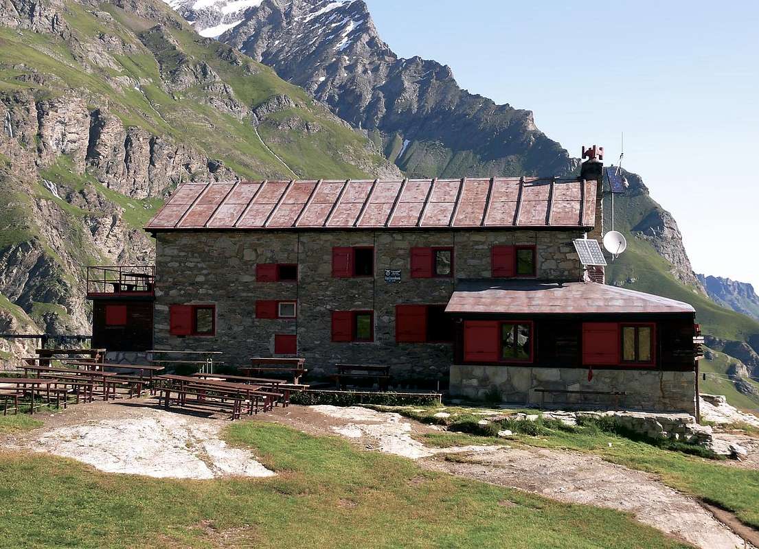
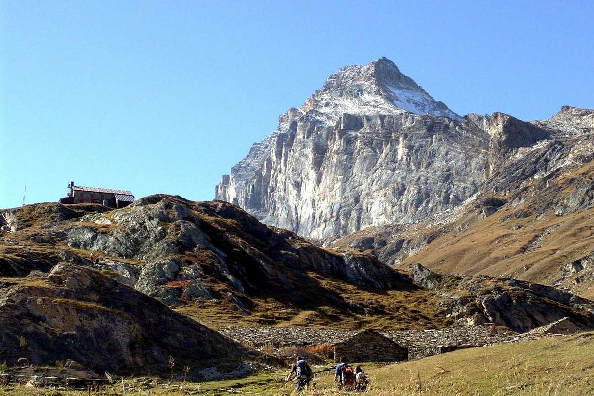
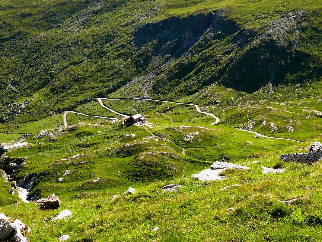
1) - from Villeneuve Municipality to alternative Valsavarenche/Rhêmes Valleys with Regional Road; from fork towards Introd, Brenloz/Tache Hamlets, Rhêmes-Saint Georges Commune, Proussaz (1.445m; Holiday Farms"Le Baton 'Or" and "Le Vieux Creton" nearby Creton (1.447m, 1.548m) and"Edelweiss"(1.600m), below Melignon, Artalle (1.654m), Carré (1.664m) Villages to Main tourist center Rhêmes-Notre Dame (1.723m). Continue on asphalt road towards Bruil (1.723m), Moulin de Chaudanne/Pellaud (+; 1.811m) Villages to Thumel Villages neighbor the torrent into a grassy plaine (1.879m; great dirt parking immediately before the same in altitude 1.848m; signal no passage). From this, before with dirt farms road to winding road 1.901 meters (various signals, panels), after through path in South and towards Saint Pantaléon (2.010m; + chapel; *** fork paths to Grand Vaudala(z) Vallon) and immediately after a winding road North/South to following Barmaverain Pasture (2.037m). Continue through false level route with a long diagonal in South below the waterfalls (2.051m) and subsequent (2.087m); crossing Roman Bridge, by dirt road also with a shortcut of path to Benevolo Refuge (2.280m), above Lavassey Pasture (2.227m; (F+; 3h'30/4h'15).
2) - from Refuge go before South and, crossing two stony small bridges on Rhêmes Doire, after change twice Northwest/South passing Sauches Alp (2.313m) and following fork (2.420m; in South path to Granta Parei/Tsantàleina Lakes); from cross instead tourning Northwest to overhanging rocky pomontory (2.615m; in South Normal Route to Granta Parei). Abandoning this last, continue on small path in Southwest reaching the effluent of Goletta Loch (2.698m). Doubling North the same e with route always Southwest, climb amongst moraines below South Face of Pointe Bassac Déré (keep a suitable distance due to the danger of falling rocks); reaching a zone more steep to cross towards a small trace into a serie of blocks and boulders rotten and broken. The subsequent slope should be carried out zigzagging between them (source hidden into rocks) and with a short traverse to the left to reach a small plateau, usually snowy. To cross with diagonal ascent on Southern border up to the final part under the pass; through an easy track to Bassac Déré Hill (3.082m); continue South on watershed Rhêmes/Valgrisenche and, through traces on North Ridge, after two Quotas (3.191m, 3.158m) to Becca of Traversière (3.337/8m) (D-; 4h'30/5h'15).
3) - from Rhêmes Notre Dame (1.723m) with Municipal Road in South to winding road 1.901 meters (stony fountain) neighbor Thumel; from this to Barmaverain-Saint Pantaléon (2.010m, 2.037m) Alps through dirt road in West (better) also path more in East and above Rhêmes Doire (T; 1h'30/1h '45; 2h'00 on dirt road). Or continue to a first series of Waterfalls (2.051m; E; 1h'45/2h'15. Note: from Alp avalanches danger; requesting the snow is transformed), just after Barmaverain Pasture.
4) - from shelter through path to rocky promontory 2.615 meters and following Goletta Lake (2.699m), under Glacier and North Face of Granta Parei (3.387m; F+; 2h'45/3h'15; same preceding remarks).
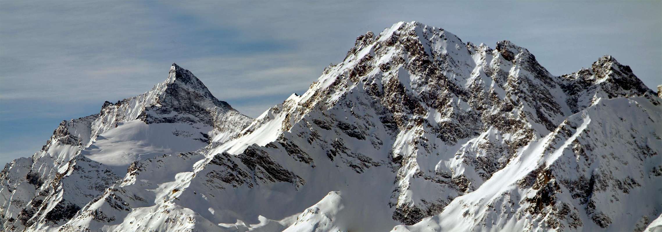
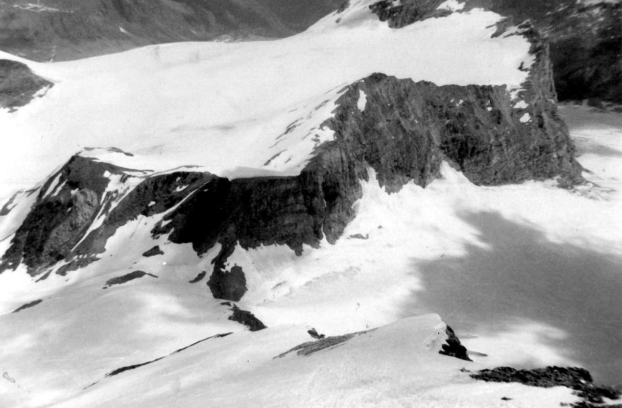
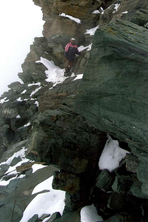
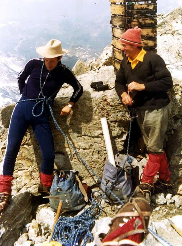
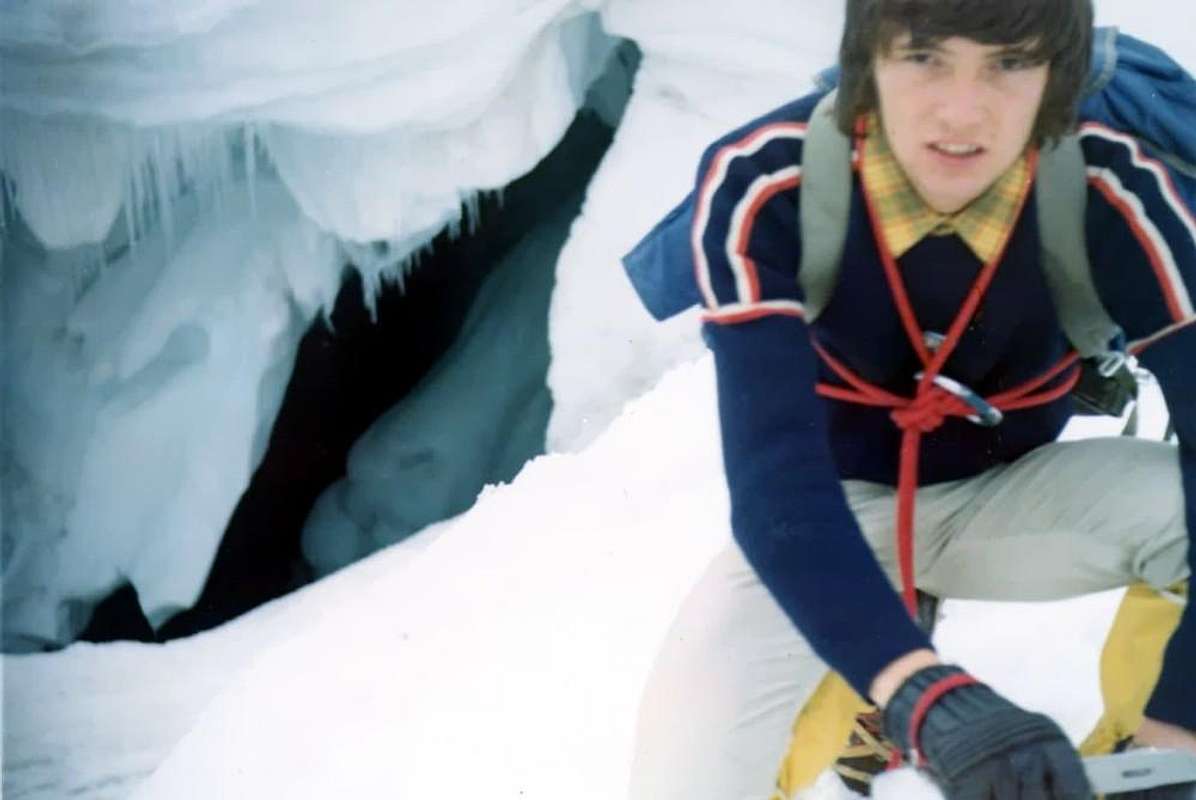
5) - (Granta Parei Tour): from refuge to fork 2.420m; continue South reaching before the small Granta Parei Lake (2.576m). Crossing the effluent and doubling West Truc de Tsantelèina (2.640m) to rocky promontory 2.706 meters before with path, after through a small trace less and less evident amongst the boulders; climbing on debris reach the point 2.706 meters just above Tsantelèina Loch (2.699m), below the vertical East Wall of Granta Parei. Passing over Western shore, through blocks and moraines, to reach the Tsantelèina and Sauches Glaciers. With delicate traverse on the same and bending more Southwest to Tsantelèina Pass (3.154m), between Pic Goletta/Tsantelèina Summits (M+; 4h'15/4h'45). Descent: before in Northwest on Rhêmes-Golette Glacier, after in North crossing completely the Northern Golette Glaciers bending Northeast below Granta Parei West and North Faces and above Goletta Lake; reached the Standard Route of the same to the base of the Northeast Ridge, with preceding routes through traces-path, to Benevolo (see the two next B&W pictures; F; 3h'00/3h'15 from pass to refuge. *** Special footnote: all the aforesaid crossing glaciers requires extreme caution, especially so for those to be carried down; this tour is not open to all and requires experience and knowledge of glaciers to a certain level; also sometimes, it is not practicable due to the state of the glaciers; in this situation is preferable return with same via.
6) - from shelter to point 2.756 meters just over the Northeastern emissary of Goletta Lake; from this to Bassac Déré Pass (3.082m), between Becca of Traversière/Bassac Déré (3.353m) Summits (M+; 4h'00/4h'30. Remark: this path can be considered a variant of the previous shortened route; typically is the busiest via).
7) - from Thumel, leaving South the path to Shelter, crossing small wooden bridge on Dora Rhêmes (splendid canyon) and through a subsequent footbridge, through small path neighbor a series of waterfalls, to overcome the first ramp into forest; after a very narrow gorge and getting closer and closer Vaudaletta Torrent reach an alternative (2.500m; in East to homonym vallon to Leynir Hill 3.084m, below Taou Blanc 3.438m) nearby Vaudaletta(z) Alp (2.443m) and under the Forest Rangers P.N.G.P. Cabin (private; 2.480m); F+; 3h'00/3h'15).
8) - from fork just before Saint Pantaléon Alps (about 2.005 meters), crossing twice on small bridges up Dora Rhêmes and Vaudala Torrent, through path zigzagging in Southeast on Vaudala Walloon to Grand Vaudala Alp (+; 2.338m) at the entrance upper part of vallon (in East-southeast path along the torrent and following vallon to Rosset Hill 3.023m, between Leynir 3.230m/Rosset 3.100m Summits; E; 2h'50/3h'10 from Thumel).
9) - from refuge through path in South-southeast and towards Basei Desot and Damon Pastures (2.309m, 2.412m), crossing various small walloons, to promontory 2.429 meters over the sources of Doire; bending more Southeast and crossing two secondaries torrent below Gran Croux (2.720m), with diagonal route amongst other height torrents and brooks reach the altitude 2.707 meters. From this, decisively East-southeast route above Northern flank of Lavassey Glacier, to fork around 3.020/30 meters under the two passes; in Northeast through path to
a) - Nivoletta(z) Pass (3.130m). In Southeast through not always too obvious traces and very rotten blocks to
b) - Basei Hill (3.176m); from this through North Crest (better to remove snowshoes), crossing the Quota 3.196 meters, to terminal part. Doubling left (Est) and overcoming a small wall (exposed and equipped passage) towards final part of ridge to Basei (+ great Cross; 3.338m; D+; 4h'30/5h'15 from refuge; F; 8h'00/8h'15 from Thumel).
10) - from Basei Pass to
a) - with traverse on watershed Rhêmes/Nivolé Tableland, to Nivoletta Pass and neighbor Southern, Northern Summits (3.163m, 3.209m; M+; 1h'00/1h'15).
b) - Variant n°3: also from fork around 3.020/30 meters through semicircular route Northeast/Southeast to pass and subsequent preceding route on enough easy South-southwest Crest. Possibility, good conditions, combine the pathways, but keep in mind that the hike is already very long for one of the two peaks: high degree of training required.
Si propone una piccola serie di 10 gite polivalenti.Le medesime infatti, rivolte al lato Orientale della valle di Rhêmes, posson essere effettuate sia con le Racchette da neve che tramite lo Sci-Alpinismo, oppure, con la bella stagione, semplicemente a piedi. Questa triplice opportunità obbliga chiaramente ad una scelta adattabile a tutte e tre le discipline, fermo restando che nulla vieta d'allargare o variare l'orizzonte con scelte del tutto personali, magari più specifica per l'una o l'altra delle stesse. Chiaramente la testata della Valle, nonché il lato Occidentale offrono molto meno la possibilità di trovare escursioni adatte a tutte e tre le specialità, per la quale cosa ci limitiamo a prendere in considerazione esclusivamente il lato Orientale arrivando fino alla Punta Basei. Nulla impedisce di frequentare gli altri due esclusi, effettuando Escursioni, gite di Sci-Alpinismo o di Alpinismo Classico; ma preferiamo lasciare questa scelta esclusivamente a titolo personale, anche se qualche piccolo suggerimento pensiamo d'averlo già dato in Overview. Ma per gli amatori delle "modernità" nonché dell'Arrampicata, non scordatevi della "Via Ferrata Casimiro Thérisod" nella parete subito al di sopra del piccolo Villaggio di Chanavey. Questa é stata attrezzata dalla Guida Alpina di Rhêmes David Pellissier nel 2010 ed é stata inaugurata nel Luglio del 2011; presenta uno sviluppo di circa 350 metri ed una valutazione di insieme come AD (abbastanza difficile). Il tempo medio é di un'ora circa, ma esiste una "via di fuga"; in ogni caso richiede attrezzatura adeguata alle vie ferrate (corda, moschettoni ecc.). Ma esistono anche altre attività sportive come le Passeggiate a cavallo a Rhêmes St. Georges in localtà La Fabrique (circa 1.200 metri); le medesime son rivolte sia a principianti che ad esperti tramite cavalli da monta inglesi ed americani. Ad Introd troviamo il "Parc d’Animalier" in località Ville Dessus, mentre sul fondovalle nelle vicinanze di Villeneuve a Chavonne (645 m) si può praticare il Rafting sulla Dora Baltea; sempre nei pressi di Chavonne esiste il "Parco Avventura" per famiglie e ragazzi, primo di questo tipo nato in Italia, offre differenti percorsi che vanno dal colore verde, per i più piccoli, al nero, esclusivamente per gli adulti oltre i 18 anni. Inoltre innumerevoli le facili e semplici Passeggiate di fondovalle con totale e completa immersione nella Natura, anche sulla media collina prima d'introdursi nella vera e propria Val di Rhêmes.
All its Vallons
This is not just a list of all existing vallons. But it can become a viable track to learn and sometimes "explore" even the most hidden corners and least known of this valley. At appropriate to have an inherent track inserted in the description of the route to be made with different notes and occasional suggestion. Certainly to be able to get out of the "common tracks" must also possess the necessary experience, in order not to go to run into some unpleasant surprise. The list and description of the same part from the valley floor to get to the opposite, that the Northern walloons of the watershed most Eastern to end the tour on those to the North of the West. Often an interesting discovery, but also such as to require a small basic preparation and, if not of the compass, certainly the use of the local various Maps; where deemed important were also reported of "Water points", such as fountains, springs, torrents or small brooks, where the same is drinking. Specifically not incorporated times climb as totally lacking where the trails are even completely "personal" and very variable. In addition, we highlight the Casotti (Cabins) of the P.N.G.P. or Gran Paradiso National Park because, although private and often closed, may still be valid means for emergencies. While not always present the Rangers or Gamekeeper, in any case can always represent a precise reference point, certainly much longer detectable in the case of rescue that non-generic indications concerning natural places such as boulders, ridges, streams that often, especially in case of fog, tend to disappear from view. We must proceed with caution before deciding to abandon a well-marked trail, secure, venturing into places that do not know, especially in case of bad weather; also you have to have the foresight to understand that where, you go up, then you have to get off. In any case, with the loss of orientation, it is always better to go down a path through even if unexpected: always take you somewhere, but did not confuse this with the ability to follow a small track, very often remnant of an old pasture since long abandoned and often directed to a site aimed at watering herbs. In case of uncertainty, better and better to reenter back.
VALLEYS & VALLONS In order to deploy clockwise from Monte Roletta-Col de Sort into the Rhêmes Valley up to the Becca of Tos Subgroup
Sort Western Vallon:
1) - from Rhêmes Notre Dame-Bruil-parking to Pra del Bosco, P.N.G.P. Cabine (2.294m), fork about 2.000 meters below Sort Alp (2.448m), traces into moraine to Sort Pass (2.970m);
2) - from this in North Mount Roletta (3.385m), traces, remains of old hunting muletrack and small easy rocks in terminal part on South Crest and Southwest Slope. Descent in East with a sea of blocks-debris in the Eastern Sort Vallon.
Entrelor Western Vallon: from Bruil-parking to Chateau-Quelet, Entrelor Hamlet, Plan di Feyes Pastures (2.403m) Entrelor Hill (3.007m), paths.
Vaudaletta Vallon: from Thumel Village-parking (1.879m), small bridge up Vaudala Torrent, path in parallel with the Torrent and its great Waterfall, Vaudaletta Pasture (2.443m) near P.N.G.P. Cabine (2.480m), ascent-traverse along the bank of the North Vaudaletta Glacier to Leynir Pass; from this in North Taou Blanc, with path and traces easily on Southwest Slope. Ski-mountaineering route. Descent to Loch Noir Vallon, Djouan Lakes and from this
1) - in Northeast Djouan Alp to Valsavarenche;
2) - in Southeast Manteau Pass, crossing on Meyes Vallon to Pont.
Gran Vaudala Vallon: from Thumel, alternative about 1.990 meters before Saint Pantaleon (2.010m) in Southeast to Grand Vaudala Pasture (2.338m), with path along the Torrent, and from altitude 2.592 meters in East (pond 2.773m in North) to Rosset Pass (3.023m), with path.
High Head Rhêmes Valley: from Benevolo Refuge in South-southeast Low and Upper Basei Pastures (2.309m, 2.412m) to Sources of Rhêmes Doire and Basei Pass, with path and traces in terminal part; from this
1) - in North Nivolettaz,
2) - in South Basei Points.
3) - Descent in East to Nivolé Tableland, with paths. All other vallons to South are covered with large glaciers and adapted exclusively for the Ski-Mountaineering or Climbing.
Comba de Golette: from Refuge Benevolo (2.280m) by small two bridges to Sauches Pasture (2.313m), Golette Lake (2.699m), Bassac Déré Pass (3.154m), with paths and snowfields; from this
1) - in South Quota 3.191m, small saddle 3.158 meters to Becca of the Traversière (3.337m), through path-traces and easy small rocks in final part.
2) - Descent in Northwest before with traces, after path to Bezzi Shelter in Grisenche Valley.
Combassa Vallon: from Barmaverein Alpage (2.037m) in West-southwest, path n° 14, to
1) - Forest Rangers Bivouac (2.425m; private, source) and in West to Bassac Hill (3.154m); descent in West-northwest, path n° 12B, to
2) - Bezzi Refuge in Valgrisenche. From bivouac in Northwest, pathless and through moraines, to
3) - Truc Blanc Lake (3.139m), crossing the glacier, Truc Blanc Pass (3.241m); descent in West on
4) - Saint Martin Glacier, and through moraines with traces San Martino Lake (2.770m) and, with path n° 12A, to Bezzi Shelter (2.284) in Valgrisenche.
Fos Vallon: from Thumel, Fos Pasture (2.062m), with dirt road, and along Fos Torrent without path to Fos Glacier and upper Carving (3.294m).
Torrent Vallon:
1) - from Rhêmes to Torrent Pasture (2.170m) with path on Haute Route n° 2 steeply to Fenêtre de Torrent Pass (2.840m);
2) - descent in West in Epée Vallon to Epée Shelter, with path. From Refuge to
3) - Grisenche Valley, farms road to Arolla, Usellières Villages.
Cussunaz Vallon: from Chanavey (1.696m) path along torrent to Cussunaz Alp (2.260m); traces to point 2.369 meters, ascent on Cussunaz Pass (2.885m). Descent in West Bruille, Praz Londzet, Benevy Pastures (2.481m, 2.220m, 2.095m) to Beauregard Dam in Valgrisenche, with path.
Feleuma(z) Walloon: from Melignon Village (1.570m) to Champ Chevalé Alp, Feleumaz Pasture (2.245m) with path, after moraine to Feleumaz Pass (3.001m); descent in West to Plontaz Pasture (2.003m), traces and path and from this to Mondanges (1.652m) in Valgrisenche, path or dirt road.
Tz(s)aboc-Courthoud Vallon: from Courthoud (1.675m) in Southwest Upper Lor (1.915m) with dirt road, alternative about 2.200 meters before Feleumaz Pasture and in Northwest altitude 2.305 meters to Courthoud Torrent (2.426m), with paths; from this point in West along the same to a small debris basin below the East Face of pass, with grassy, debris and moraine. Through a morainic cone climb to grassy and inclined ledges and two next couloirs (snow possibility) up to the rocky terminal part. Path more dangerous than difficult, it requires good experience and a sure-footed. In Southwest Tzaboc Point, through Northeast Crest with a passages of II°; exposed to Northeast, experience and rope required.
Prochetty, Perarsaz, Chairry, Southern Balanche, Ligne, Northern Balanche and la Guettaz Vallons: All these walloons perpendicular to the watershed between the Becca of the Luetta and Mount of the Ane take their name from their torrents, they have the characteristic of being very steep and dangerous, for which reason they are inadvisable if not in the path at low altitude and not always in every case. A connecting trail crosses from North to South all these vallons, cutting halfway average altitude of about 2.300 meters. A very ancient path connecting that allowed the passage, even with mules, between the Communities of Arvier, Introd and the above hill with the first fraction at the entrance of Valgrisenche Valley, always with all parts of the Valley of Rhêmes. In any case the slopes over this path are really rough and generally routes only by very experienced hunters or mountaineers. The undersides offer steep cliffs furrowed by vertical icy waterfalls in winter, great playground for lovers of this sport. Unfortunately, on the same have already been some terrible misfortunes. The same is reunited with some trails that come from the valley floor, also with Rhêmes Saint Georges-Voix (1.184m), Planpra (1.607m), Courthoud 1.675m) and Melignon (1.570m) Villages.
Non é questo un semplice elenco di tutti i valloni esistenti.Bensì può diventare una valida traccia per conoscere ed a volte "esplorare" anche gli angoli più reconditi e meno conosciuti di questa valle. All'uopo abbiamo inserito nella descrizione una insita traccia del percorso da effettuarsi con diverse annotazioni e qualche sporadico suggerimento. Certamente per poter uscire dalle "comuni piste" bisogna anche possedere la necessaria esperienza, onde non andar ad incorrere in qualche spiacevole sorpresa. L'elencazione e la descrizione dei medesimi parte dal fondovalle per arrivare all'opposto, ovvero dai valloni più Settentrionali dello spartiacque Orientale per terminare il tour su quelli a Nord di quello Occidentale. Spesso una scoperta interessante, ma tale da richiedere anche una piccola preparazione di base e, se non della bussola, sicuramente dell'uso delle Carte locali; dove ritenuto importante son stati segnalati anche dei "punti Acqua", come fontane, sorgenti, torrentelli o ruscelletti, laddove la medesima risulti potabile. Appositamente non sono stati inseriti gli orari di salita, poiché dove mancano totalmente i sentieri diventano ancor più completamente "personali" e molto variabili. Inoltre vengon segnalati i Casotti del Parco Nazionale del Gran Paradiso perché, seppur privati e spesso chiusi, possono comunque costituire mezzo valido per eventuali emergenze. Pur non essendo sempre presente il Guardiaparco, in ogni caso possono sempre rappresentare un preciso punto di riferimento, sicuramente molto più individuabile in caso di soccorso che non generiche indicazioni concernenti luoghi naturali come massi, creste, torrenti tendenti spesso, soprattutto in caso di nebbia, a scomparire alla vista. Procedere con una certa cautela prima di decidere d'abbandonare un sentiero ben segnalato e sicuro, avventurandosi in posti sconosciuti, soprattutto in caso di cattivo tempo; inoltre si deve avere la lungimiranza di capire che, dove si sale, poi si deve scendere. In ogni caso, con perdita dell'orientamento, é sempre meglio tornare tramite un sentiero anche se imprevisto: in qualche posto sempre vi porterà, senza però confondere questa possibilità con quella di seguire una piccola traccia, molto spesso residuo d'un vecchio pascolo ormai da tempo abbandonato e sovente indirizzato ad un luogo rivolto all'abbeveraggio delle mandrie. In caso d'incertezza, molto meglio rientrare subito.
Campings
Remember that free camping is forbidden (except for emergency reasons, over 2.500m, from darkness until dawn).
Mountain Conditions
You can get meteo information at the official site of the Regione Valle d'Aosta:
"Guida delle Alpi Occidentali" di Giovanni Bobba e Luigi Vaccarone C.A.I. Sezione di Torino Volume II (parte II), 25 Maggio 1896.
"Guida dei Monti d'Italia-Gran Paradiso Parco Nazionale" E. Andreis, R. Chabod, M. C. Santis, Club Alpino Italiano/Touring Club Italiano, prima Ed. 1939; seconda Ed. 1963; terza Ed.
"Rifugi e bivacchi in Valle d'Aosta", di Cosimo Zappelli aggiornata da Pietro Giglio, Musumeci Editore, Luglio 2002.
MAPS:
Kompass "Gran Paradiso Valle d'Aosta Sentieri e Rifugi" Carta Turistica 1:50.000.
Enrico Editore Ivrea-Aosta "Gruppo del Gran Paradiso" 1:50.000.
I.G.C. Istituto Geografico Centrale Carta dei sentieri e dei rifugi "Valsavarenche-Val di Rhêmes-Valgrisenche" 1:25.000.
Parents refers to a larger category under which an object falls. For example, theAconcagua mountain page has the 'Aconcagua Group' and the 'Seven Summits' asparents and is a parent itself to many routes, photos, and Trip Reports.


 4507 Hits
 83.69% Score
 17 Votes