
|
|
Mountain/Rock |
|---|---|
|
|
40.83050°N / 106.6925°W |
|
|
Hiking, Scrambling |
|
|
Summer, Fall |
|
|
12059 ft / 3676 m |
|
|
Overview
Not long ago SP member and deep snow trail-breaker extraordinaire Colonelpyat submitted the Mount Zirkel page. Included was his excellent photo:
"Looking west towards Big Agnes Mountain", taken from near the summit of Mount Zirkel: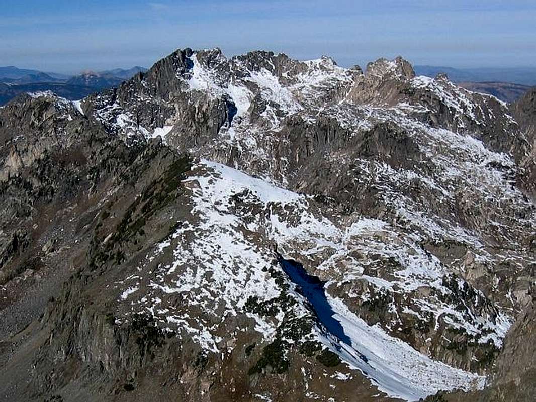
I thought, "Hey, I climbed Big Agnes the first summer that I was in Colorado (1978). I can submit it to SP!" I may not remember much about the climb, but I can point you in the right direction, and can definitely say that the Mount Zirkel Wilderness is worth many visits.
Who The Heck Was Big Agnes?
I have no idea.
Raymond Ave, the author of a Mount Zirkel Wilderness guidebook and website responded to my email inquiry:
According to the Historic Guide to Routt County, Big Agnes Mountain was named by Robert McIntosh who prospected the area for gold in 1875. It didn’t really say who Agnes was. That’s all I know. I also know that the Historic Guide to Routt County said that Mt. Zirkel was named for an trapper who lived near the mountain, but in fact it was named for Ferdinand Zirkel who (according to documents from the US Geologic Survey) conducted petrographic analysis on some rock samples collected on a geologic exploration in the area in the late 1800’s – so I always take whatever I read in the Historic Guide to Routt County with a grain of salt.
A similar question to Routt National Forest Service office came up empty-handed. Web search hits turn up the name of a sleeping bag manufacturer in Steamboat Springs. So whoever Agnes was, in exactly what manner she was big, and why Robert McIntosh named a mountain after her remains a mystery.
Where The Heck Is Big Agnes Mountain?
That I can answer. It is in the heart of the Mount Zirkel Wilderness of north-central Colorado, north of Steamboat Springs. The peak is some 7 miles from the Gilpin Lake trailhead.
Getting There

The Gilpin Lake trail on the west side of the Mount Zirkel Wilderness provides access to Big Agnes Mountain.
The following is pasted from the above Forest Service link, regarding the road to the trailhead:
Drive west out of Steamboat Springs on Hwy. 40 approximately 2 miles and turn right on Elk River Road (County Road 129). Follow CR 129 about 18 miles to the Seedhouse Road (Forest Development Road 400; also CR 64) and turn right. Continue for about 10 miles to the end at the Slavonia trailhead parking. USE: Very Heavy
This road was affected by the Routt Divide Blowdown and is not open past Coyote Park as of 06/99. Users have to park in Coyote Park and walk in two miles on the road to get to the Slavonia trailhead.
The hike is through beautiful conifer and aspen groves towards Gilpin Lake. At about 1.5 miles there is a junction that heads north into Mica Basin. That route gives access to Big Agnes from the west. Big Agnes is easily climbed from via the Southeast Ridge route. The Gold Creek Lake trail is one of several variations you can use to return to your car.
A full list of trails in the Routt National Forest can be found here.
 |
 |
 |
 |
 |
When To Climb
Typically June through September. Road access to the trail head will be probably be limited in winter. The Forest Service has a current conditions page, which seems to be of limited usefulness.
Sawtooth Range from Big Agnes
Camping
The Forest Service Seedhouse Campground is located near the trail head. There is a $10 camping fee. The Forest Service link is not clear if that is per night or per stay, up to the 14-day limit.
 |
Red Tape
Big Agnes is in the Mount Zirkel Wilderness of the Routt National Forest. Wilderness camping regulations apply.
This link provides full regulatory details: www.wilderness.net
Note that special regulations apply to backcountry camping near Gilpin and Gold Creek Lakes due to heavy use. From the above Forest Service site:
Due to the popularity and easy accessibility of this trail, this area receives some of the highest use of any area in this wilderness. This trail is not suggested if you are seeking solitude. Gilpin, Gold Creek and Three Island Lake trails are the most heavily used areas on the district. If seeking solitude, please refer to trails less heavily traveled. Overuse and abuse have led to implementing special regulations in hopes for revegetation. Regulations prohibit camping within 1/4 mile of the lake. Please camp elsewhere using low impact techniques or visit Gilpin Lake on day hikes.
Leave No Trace
Since reaching Big Agnes requires several miles of cross country travel through pristine wilderness, please follow Leave No Trace guidelines when in the area.
The joys of a mountain like Big Agnes are as much the privilege of hiking through such beauty as the climb itself. Let's help it remain that way for future visitors.
The following is pasted from the above Bureau of Land Management link, which I feel free to post here since it is my tax dollars at work:
- Plan Ahead and Prepare: Proper trip planning and preparation helps hikers and campers achieve trip goals safely and enjoyably while minimizing damage to natural and cultural resources. Poorly prepared campers, concerned with unexpected situations, often resort to high-impact solutions that degrade the outdoors or put themselves at risk.
- Camp and Travel on Durable Surfaces: Damage to land occurs when surface vegetation or communities of organisms are trampled beyond repair. The resulting barren area leads to unusable trails, campsites and soil erosion.
Should you concentrate activity, or spread out? In high-use areas, campers should gently concentrate activity. Use trails whenever possible and select camp sites so heavily used that further damage is unlikely. In areas of very little or no use, campers should gently spread out. Take different paths when hiking off trail to avoid creating new trails that cause erosion. When camping, disperse tents and cooking equipment and move camp daily to avoid creating permanent-looking camp sites.
These guide lines apply to most alpine settings and may be different for other areas, like deserts. Check if unsure. - Pack it In, Pack it Out: This common saying is a simple yet effective way to get back try visitors to take their trash home with them. There is no reason why people cannot carry out of the back try the extra materials which they carried in with them in the first place. Though most trash and litter in the backcountry is not significant in terms of the long term ecological health of an area, it does rank high as a problem in the minds of many backcountry visitors. Trash and litter detract from an area's naturalness.
- Properly Dispose of What You Can't Pack Out: Backcountry users create body waste and waste water which requires proper disposal.
Waste water: Prevent concentration of natural water sources; disperse dishwater far away from springs, streams, and lakes. Minimize the need to pack out food scraps by carefully planning meals. Avoid the use of soap.
Human waste: Proper human waste disposal prevents spread of disease, exposure to others, and speeds decomposition. Catholes, 6 to 8 inches deep and 200 feet from water, are often the easiest and most practical way to dispose of feces.> - Leave What You Find: Allow others a sense of discovery; leave rocks, plants, archaeological artifacts and other objects as found.
- Minimize Use and Impact of Fire: Some people would not think of camping without a campfire. Yet, the naturalness of many areas has been degraded by overuse of fires and increasing demand for firewood. Lightweight camp stoves are essential for low-impact camping and have engaged a shift away from fires. Stoves are fast and eliminate firewood availability as a camp site selection concern. If building a fire, the most important consideration is the potential for damage.
The best place to build a fire is within an existing fire ring in a well-placed campsite. Choose not to have a fire in areas with little wood at higher elevations, in heavily used areas, or in desert settings. True Leave No Trace fires show no evidence of having ever been constructed.