
-
 9204 Hits
-
 78.27% Score
-
 9 Votes
|
|
Mountain/Rock |
|---|---|
|
|
42.76634°N / 0.13842°W |
|
|
Mountaineering |
|
|
Spring, Summer, Fall |
|
|
10561 ft / 3219 m |
|
|
Overview
 Monferrat, West face
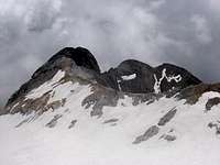
Montferrat or Monferrat (3219m) is of all the peaks of the Vignemale Massif that can be climbed from the Glacier d’Ossoue the one that is found more displaced toward the S. and the one that presents the most difficult normal route. Although it is certain that so much the Tapou as the Petit Vignemale would be of more difficult access, both possess easier normal routes by others sides.
 Montferrat, NW view
The Vignemale Massif is composed by two great ridges, North and South, and Monferrat is an important peak of South ridge. The full list of peaks of South ridge from West to East are: Cerbillona (3247m), Aiguille SW of Cerbillona (3051m), Central (3235m), Montferrat (3219m), Aiguille Sup. Tapou (3132m), Aiguille Inf. Tapou (3124m), Grand Tapou (3150m) and Milieu (3130m). The three most important and relevant are Cerbillona, Montferrat and Tapou.
Generally the majority of the mountaineers they will discover this peak when they approach the Glacier d’Ossoue, in direction to Grand Vignemale ( 3298m) and they observe their pretty pyramidal silhouette to the left. Due to the dangerous glacial zone that is visible below our summit, with seracs and crevasses, it's obvious that the route is not direct and requires more explanations and that have its own web in SP. It's a peak that generally requires his own route and is combined only a few times with other summits of the massif except if spend several days in Bayssellance. A good combination is to climb the nearest, Central (3235m) and Cerbillona (3247m) after, o before, of his summit.
 |
 |
 |
Routes
 Vignemale massif
-glacier of Ossoue: P.D.inf. (II or II-). The glacier is reachable from Barrage d’Ossoue or from Bayssellance (with approach from Pont d’Espagne the previous day).
-from Tapou: the peak Tapou (3150m) is reachable across his normal route from Barrage d’Ossoue (F), but exist a prolongation across the two Agujas (aiguilles) of Tapou in direction to Monferrat in bad rock exposed (P.D., III-).
The shortest route to climb the peak in one day is across the glacier of Ossoue with trailhead in Barrage d’Ossoue.
Getting There
Access from the French side by road is from the East-West autoroute E80 (Bayonne to Toulouse) and the National road N21 via Lourdes and the D821 / D920 to Cauterets or the D921 to Gavarnie. There are airports at Pau and Toulouse. In Gavarnie is the access to Barrage d'Ossoue and in Cauterets is the access to Pont d'Espagne, the two trailheads of the peak.Access from Spanish side by road from the N.W. or W. of the country: across Irun to cross to France, taking the road to Bayonne and the same French way.
Access from Spanish side in the centre of Pyrenees (near Huesca): the best option in the entry in French territory across Col du Portalet or Col du Somport. In winter many days this road is closed by the snow (or it requires the use of chains). D918 to Argelès-Gazost, D12 and D921 to Gavarnie.
Red Tape
No permits are required. If you want to sleep in the Refuge is advisable the reserve by phone.Camping
In the National Parks camping is normally not allowed, except in a place of more than 1h of walk of a refuge, but it's very difficult in the route from the North (Oulettes de Gaube) because it exist two refuges (Gaube and Bayssellance). The best options to camp are near of Barrage d'Ossoue, in the South approach, with some places indicates near of the dam.-Refuge de Bayssellance
-Refuge des Oulettes de Gaube