
-
 31019 Hits
-
 87.31% Score
-
 24 Votes
|
|
Mountain/Rock |
|---|---|
|
|
39.65400°N / 106.1892°W |
|
|
Summit |
|
|
Hiking, Scrambling |
|
|
Spring, Summer, Fall |
|
|
13357 ft / 4071 m |
|
|
Overview
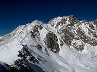
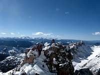
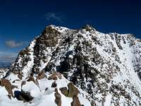
"Mount Silverthorne", or Willow Benchmark as it appears on USGS Maps, is the third highest summit in Colorado's Gore Range, and 351st overall in Colorado. While the borders of the Gore Range can be hard to nail down geographically, the rugged heart of the range most people are familiar with resides within the boundaries of Eagles Nest Wilderness on the Eagle and Summit County border. This rugged range crest is home to many jagged peaks and spires, many unnamed and referred to only by nicknames awarded them from the Colorado Mountain Club and other early climbers in the range. "Mount Silverthorne" is one such nicknamed peak, named for the way it towers above the nearby town of Silverthorne.The peak itself acts as the southern anchor point for the Eagles Nest Wilderness, and rises with an impressive 1,097' of prominence, a lot for this particular range where peaks are more part of a ridge line than they are individual summits. Despite its height, prominence and proximity to civilization, it remains a reclusive peak. From I-70 the view of the peak is largely obscured by its sub-summit "East Thorne" and by Red Peak to the south.

Many people view this peak from the top of neighboring summits, and among 13ers it is one of the lesser climbed peaks. It is precisely this reclusive nature that makes this peak such a worthy destination, and those who venture here are rewarded. To that end I do not plan on adding a route page for this peak, but instead provide a loose description and a couple of images to get you started, and let you explore the upper reaches yourselves to help preserve a bit of the wonder of this special place.

Getting There
There are two main access points for summit attempts on "Mount Silverthorne" - Salmon Lake on the east, or Gore Lake on the west. Both approaches involve a long trail hike before leaving the trail and finding ones way to the summit via bushwhacking, talus hopping and a little scrambling.From the East (Salmon Lake): Exit I-70 at exit 205 (Silverthorne) and turn left on Wildernest Drive (1st traffic light) just north of I-70. Turn right on Buffalo Drive, turn right on Buffalo Mountain Drive, take the first left onto Lakeview Drive, and then left on Aspen Drive and park at the trailhead for the "Mesa Cortina Trail". Open year round.
From the West (Gore Lake): Exit I-70 at exit 180 (East Vail) and follow the south frontage road (Bighorn Road) for just over 2 miles. The road will pass under I-70 and there will be a large dirt parking area on the left and the singed "Gore Creek/Deluge Lake" trail. In winter the road is plowed until the highway crossing.

Route Information
Any route on "Mount Silverthorne" will be a long committing route deep in the heart of the rugged Eagles Nest Wilderness. Plan for a full day, and in summer plan on an early start to avoid typical afternoon thunderstorms.A route from the east would start at the Mesa Cortina Trailhead and follow trails to Salmon Lake, which is about 9 miles one way from the trailhead. From the lake the peak requires 2200 vertical and about 3 miles round trip of additional effort, an overnight camp is highly recommended if approaching from this side. The hiking route to the lake is well described here. Approximately 21 miles RT and 4500 vertical
From the west the route is shorter, but has more elevation gain. Follow the Gore Creek trail approximately 4 1/2 miles to the Recen Brothers grave site at approximately 10,200'. Turn north and follow the Gore Lake Trail for about 1 mile then leave the trail and head north-northeast to treeline and eventually the south ridge. Some scrambling is involved between the false summit and true summit, but can be kept to class 3. Approximately 15 miles RT and 5000 vertical.
Camping
Both trailheads lie close to residential areas, the only camping near the trailheads would be at the Gore Creek Campground just past the Gore Creek trail parking area. There is a small fee.The peak lies within Eagles Nest Wilderness and backcountry camping is plentiful, just be sure to follow Leave No Trace and the Wilderness Area regulations for camping off trail, away from lakes and streams, and not within 1/4 mile of treeline. Campfires are allowed, but subject to Wilderness regulations and possible restriction during high fire danger.

Red Tape
"Mount Silverthorne" resides in Eagles Nest Wilderness of the White River National Forest, and is subject to the regulations of that area including no motorized or mechanized travel, leash regulations for dogs, and restrictions on camping locations, group size, feed for pack animals, and storage of materials. Read more about the requirements at the US Forest Service home page here.The east side is part of the Dillon Ranger District, with offices in Silverthorne just north of the outlet malls on the east side of Colorado 9 (970) 468-5400. The west is in the Eagle Ranger District, with offices on US 24 just south of the Minturn exit (970) 827-5715.
Special Considerations
The routes for this peak are rather long, and unless one has great weather or is a fast hiker, success depends on an early start or even a high camp. This area is so beautiful, a high camp is highly recommended!Winter routes in the area would require extreme caution as the steep rugged mountains here are very prone to avalanches in the winter. I would not recommend a winter ascent of this peak.
Crampons and Ice Axe highly recommended for ascents in the spring as the approach slopes are steep and stay snow covered generally into July.
If approaching from Gore Lake, a side trip up the neighboring "Zodiac View", and unranked 12er, is a worhtwhile side trip to check out the rugged spires of the zodiac ridge - the ridge that connects "Mount Silverthorne" to Red Peak.
Weather Link
Avalanche Forecast Link
