
|
|
Mountain/Rock |
|---|---|
|
|
39.67980°N / 106.2581°W |
|
|
13005 ft / 3964 m |
|
|
Overview
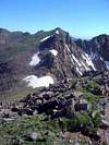
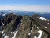
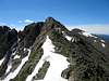
Climbers Point (13,005 ft) and Skiers Point (roughly 12,930 ft) are two prominent points along the ridge that separates the Pitkin Creek drainage on the west and the Bighorn Creek drainage on the east. These points are equally accessible from either of these drainages. The ridge between the two points is easy class two and the ridge south of Skiers Points is a little more difficult class two with a class-three notch as its crux.
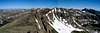
The views from these points are amazing. All the lettered peaks are jumbled together to the north and unless you’ve really been studying a map it can be very difficult pick them out. There are just so many interesting-looking mountains packed in so close together! To the southeast there are more fantastic looking mountains, but this far south the namers had run out of letters so the prominent summits have names like Mount Valhalla, Snow Mountain, Rain Peak, East Thorn, and Red Peak. These views will certainly inspire future trips into the Gores.
 |  |  |  |  |
Getting There
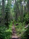
Bighorn Creek Trailhead: From the Front Range drive west on I-70 to Vail. Exit I-70 at the easternmost exit (180) and take an immediate left onto Big Horn Road to go under I-70. Follow Big Horn Road back east for less than a mile to Columbine Drive. Take a left on Columbine Drive and go back under I-70 and up the hill a couple hundred yards. You’ll find a small parking lot on the left side of the street.
Pitkin Lake Trailhead: From the Front Range drive west on I-70 to Vail. Exit I-70 at the easternmost exit (180). Turn right and quickly make another right and drive about .2 mile east. Look for the trailhead on the left next to some private condos.
 |  |  |  |  |
Red Tape
No fees or permits are required. Climbers Point and Skiers Point are located within Eagles Nest Wilderness so all normal wilderness guidelines apply.
 |  |  |  |  |
When To Climb / Mountain Conditions
Climbers Point and Skiers Point are best climbed June through September to avoid large amounts of snow. However, it would be possible to climb these mountains year round because of the relatively short approach and excellent trailhead access. Click here for a Vail weather forecast. For more detailed conditions contact White River National Forest.
Contact White River National Forest
| Eastern Portion of the Wilderness: Dillon Ranger District 680 River Parkway Silverthorne, CO 80498 970-468-5400 | Western Portion of the Wilderness: Holy Cross Ranger District P.O. Box 190, 24747 US HWY 24 Minturn, CO, 81645 970-827-5715 |
Camping
There isn't much car camping near either the Bighorn Creek Trailhead or the Pitkin Creek Trailhead because they essentially start in the town of Vail. To car camp I'd try near the top of Vail Pass or up U.S. 24 past Minturn. However, if you're willing to pack your gear up the trail a little ways there are many great campsites up both the Bighorn Creek Trail and the Pitkin Creek Trail. No permits are necessary and there are no restrictions on where you can camp once inside the Eagles Nest Wilderness Boundary.
External Links
- Theron Welch's web site
Theron's web site is the definitive guide to the Gores. His trip reports will continue to inspire SP members' adventures in the Gores