
-
 17177 Hits
-
 85.35% Score
-
 20 Votes
|
|
Mountain/Rock |
|---|---|
|
|
39.67100°N / 106.2393°W |
|
|
13079 ft / 3986 m |
|
|
Gore Range Overview
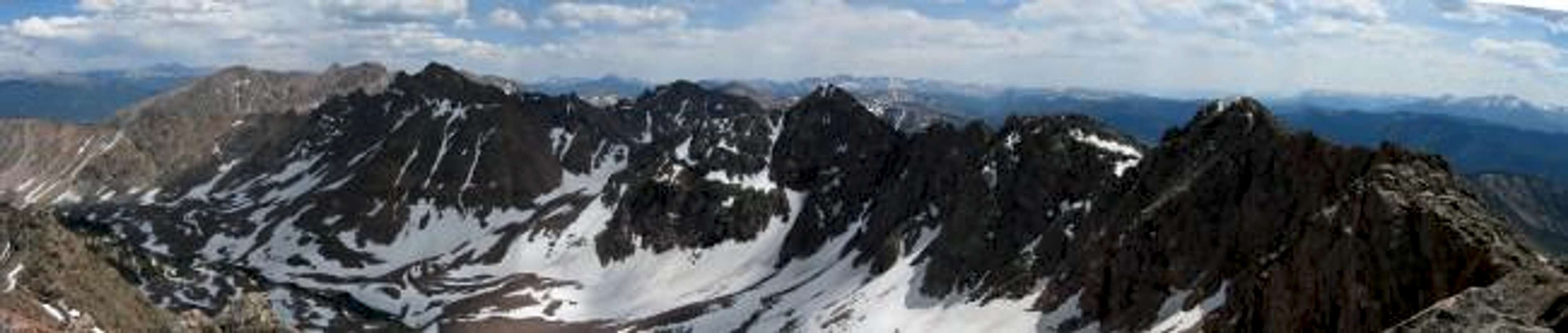
Panoramic view south from the summit of North Traverse Peak. The high mass in the sunlight on the left consists of Rain Peak, East Thorn, and Willow Peak. The closer three mountains in shadow are Mount Valhalla, Snow Peak, and Grand Traverse Peak, with the latter being connected to North Traverse by the Grand Traverse Ridge along running the right side of the photo.
 Colorado’s spectacular but barely known Gore Range is host to many alpine summits over 13,000-ft and many more summits over 12,000-ft. In the relatively short stretch from Gore Pass in the north to Tenmile Creek in the south, the Gore range is densely populated with 50 some mountains over 12,000-ft. The Gores, rather then consisting of large isolated mountains rising from the timber or tundra, consist instead of dramatic serrated ridges, with the summits being ridge junctions or highpoints. These dramatic ridges are riddled with gnarled, tooth-like spires that have mesmerized many world-class climbers. Many of these high and wild ridges actually have names like, The Zodiac Spires, Ripsaw Ridge, and The Grand Traverse.
 Geologicaly the Gore Range is a fault-block mountain range. Similiar to the Sangre de Cristos of Colorado and the Tetons of Wyoming in that these ranges are bounded by faults that broke and shifted, thrusting up the mountains while downdropping the valleys. Although the rock is similiar to the Idaho Springs Formation of the Front Range, the rugged Gore's contrasting orogensis makes these mountains look quite different from the glaciated folded anticline that makes up the Front Range. Glaciers played an extensive role in carving the cirques and spires that abound in the Gores. Many of the drainages are choked by large terminal morraines at their lower reaches and cut by successive headwalls higher up. Many headwalls are graced with gorgeous waterfalls.
The Gore Range is almost completely encompassed by the Eagles Nest Wilderness. This 133,325 acre Wilderness Area was established in 1976. It is popular (especialy the Vail side) but wilderness protection has granted a lasting pristene quality that is palpable. Despite the network of access trails, many drainages (the upper reaches in particular) remain trail-less. Wilderness regulations do apply; please follow them as this area is a real treasure.
Only 60 miles at its closest point from Denver, the Gore Range as a whole is relatively unknown. Due to the lack of mining roads that criss-cross more popular mountain ranges the interior of the Gore Range can be difficult to reach. Of the summits of the Gore Range none attain the magic 14,000-ft mark, which accounts for some of the ranges obscurity. The monarch of the Gore Range is the 13,534-ft. Mount Powell at the north end of the range. Overall, the west side of the Gore Range is more accessible than the east. If approaching from the east, expect long, tedious, bushwhacking adventures with difficult route finding.
A result of the Gore Range's obscurity is that few of the summits are officialy named. The Colorado Mountain Club and enterprising climbers have often bestowed their own names. These unofficial designations often are the "alphabet" designations of the early CMC trips (relics of the 1930's) or the more inspired names that came latter on (The Spider, Mount Solitude, etc). A list of these names and their elevations can be found at Gerry and Jennifer Roach's wonderful website. The process educating one's self about these mountains is quite rewarding. Hand label your maps.
Those of us that are determined to spend some time climbing the Gores should own updated U.S. Geological survey topography maps and brush up on their compass skills. Precise planning and execution are of paramount importance when selecting routes in this range. With solid route finding, many of these quiet summits can be climbed without a rope. Major faces and long jagged ridges provide unlimited technical climbing opportunities as well. An ice axe is highly recommended on any early season climbs.
Please do your own research and homework for the Gores because this mountain range lacks any current guidebook exposure. After developing strong map reading skills, go and discover for yourself the Gore Range magic you occasionally hear about.
Please see Theron Welch's excellent page on the Gore Range for more information. His photos and descriptions are inspiring and informative. Thank you Mr. Welch.
Text graciously provided by Kane with some elaboration by myself.
North Traverse Peak Overview
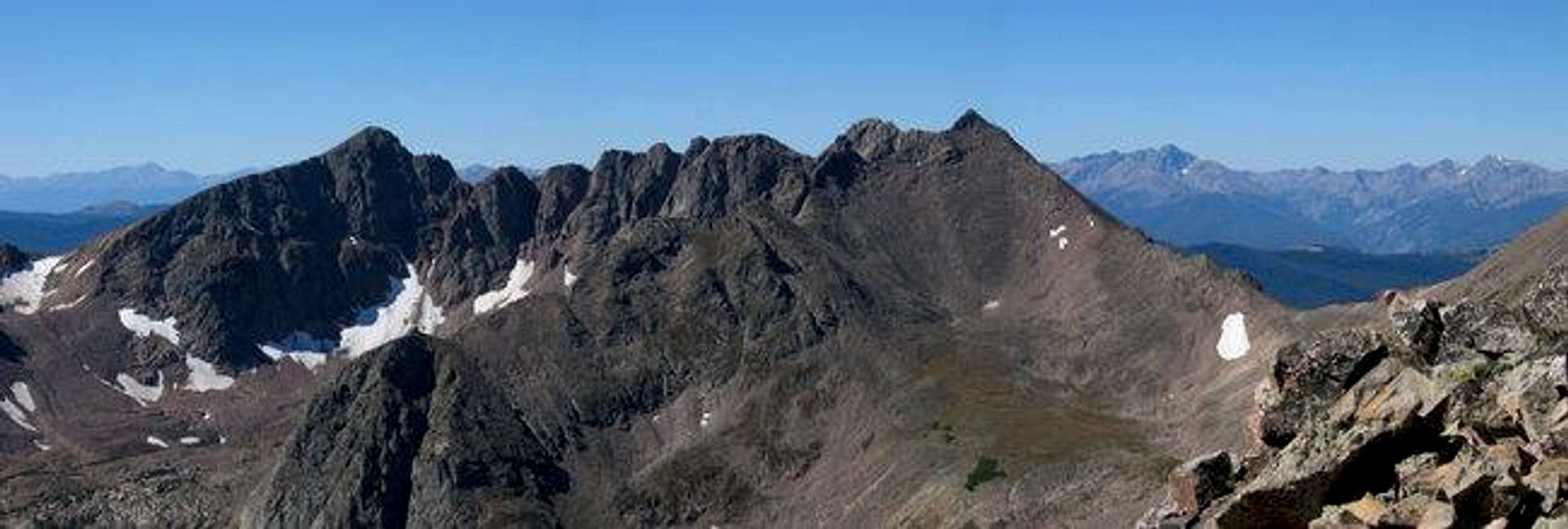
Grand Traverse Peak, The Grand Traverse, and North Traverse Peak from the East Ridge of Keller Mountain.
North Traverse Peak is a spectacular summit located in the central section of the Gore Range. Along with Grand Traverse Peak, North Traverse Peak guards over the majestic Grand Traverse Ridge. The view of this ragged ridge of smooth slabs of granite stacked one upon another and bound between the twin bookends of Grand Traverse Peak and North Traverse Peak instills vertigo and awe in equal measure. The dichotomy of these summits is that they are defined almost as much by the ridge that joins them as by their own loft.
Grand Traverse Peak and North Traverse Peak are seperated by only 0.7 miles and a lowpoint 301 feet below the summits. If these mountains were located in one of Colorado's other mountain ranges it would likely to be a lark to get from one mountain to another. The Gores' propensity for grandoise serrated ridges makes a mighty showing with The Grand Traverse. To traverse between these summits requires a commiting route along a high ridge composed of a dizzing array of towers and notches. Route finding would surely be exciting and the climbing would likely be of 4th to 5th class. The Grand Traverse Ridge can be admired in style from the summit of North Traverse Peak .
North Traverse Peak is a large high ridge of a mountain (Kane likened it to the Arapahos in IPW). The upper mountain is boulder strewn and graced with a few mini-towers while the lower slopes are consist of either remarkably steep grass or lood talus slopes. A skirt of talus surrounds the mountain. North Traverse appears to have two summits of similiar height. The northern summit is the offical highpoint at 13,079 ft but the southern summit would offer a worthy vantage of the Grand Traverse Ridge.
North Traverse Peak is most easily ascended from the Bighorn Creek drainage. North Traverse Peak makes up the eastern boundary of this beautiful basin. A route accessed from the head of the Bighorn Creek basin (near the unoficialy named Central Pass) provides easy and fun 3rd class scrambling along the mountain's north ridge. The terrain is a fun mix of steep grass and boulders. Loose rock is common but the route is not exposed. A snow climb would be an option in may or june.
The summit view from North Traverse Peak is outstanding. Being a member of the central Gores means that North Traverse Peak offers glimpses of most of the highlights of the Gore Range. In all directions siren summits call.
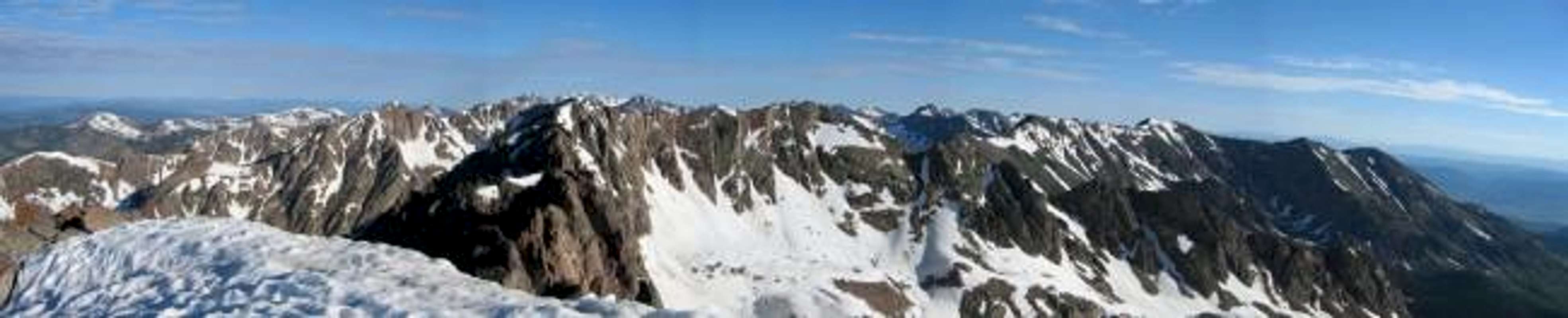
Panoramic view of North Traverse Peak from the summit of Grand Traverse Peak.
 |
Directions and Maps
Bighorn Creek Trailhead: From the Front Range drive west on I-70 to Vail. Exit I-70 at the easternmost exit (180) and take an immediate left onto Big Horn Road to go under I-70. Follow Big Horn Road back east for less than a mile to Columbine Drive. Take a left on Columbine Drive and go back under I-70 and up the hill a couple hundred yards. You’ll find a small parking lot on the left side of the street.
TH directions graciously provided by Andy
 |
Red Tape
“Red Tape” per attm
No permits or fees are required. Like all wilderness areas no mechanized or motorized vehicles are permitted within the Eagles Nest boundaries.
Wilderness is land set aside as part of wild America, where man can be a visitor. The natural environment has not been disturbed. Travel is restricted to foot or horseback. No mechanized equipment is allowed.
For more information, contact the U.S. Forest Service at the # below:
Additional Resources:
Eastern Portion of the Wilderness:
Dillon Ranger District
680 River Parkway
Silverthorne, CO 80498
970-468-5400
or
Western Portion of the Wilderness:
Holy Cross Ranger District
P.O. Box 190, 24747 US HWY 24
Minturn, CO, 81645, Phone: 970-827-5715
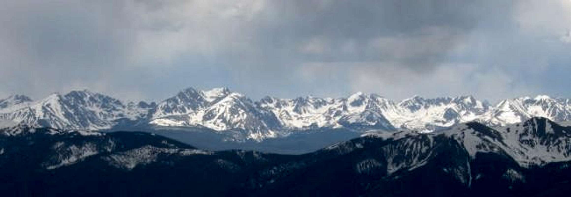
The Southern Gore Range as seen from the east. The summits are, from left to right: Red Peak, Zodiac Spires, East Thorn, Willow Peak, Rain Peak, Hail Peak, Snow Peak, Mount Valhalla, Grand Traverse Peak, The Grand Traverse, North Traverse Peak, and Keller Mountain.
Camping
Backpacking campsites are available up the Bighorn Creek Drainage. Aproximately 2-3 miles from the Trailhead the terrain levels out and many decent sites can be found. Aproximately 3 miles in a dilapidated cabin is present but I would recommend against its use in anything but an emergency. It is open but dirty and not quite weatherproof.
Mountain Conditions
Expect snow up Bighorn Creek drainage until early June.
Click image to enlarge
Click here to view a 7-day forecast for Deluge Lake Basin at 11,400-ft

Text graciously provided by Kane
Scott - Aug 28, 2005 6:40 pm - Hasn't voted
Untitled CommentJon, I know you don't mention the campground on the page, but this may be worth mentioning somewhere:
The campground that is shown on the maps that is not far from the trailhead is closed to tent camping because of bear problems. Only "hard walled" RV's are allowed.
It might be worth mentioning somewhere so someone doesn't show up near the trailhead or Vail late at night looking for a campsite to do the climb the next morning.
RyanS - Oct 7, 2020 1:24 pm - Voted 10/10
Bighorn TrailheadIt appears that Vail has placed a three-hour parking limit on the Bighorn TH, including prohibitions on overnight parking. This obviously complicates use of this trailhead for North Traverse Peak.