
|
|
Mountain/Rock |
|---|---|
|
|
42.18560°N / 113.6603°W |
|
|
10339 ft / 3151 m |
|
|
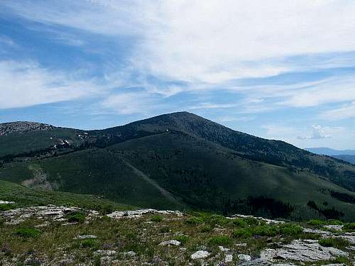
 Looking at the east side
Overview
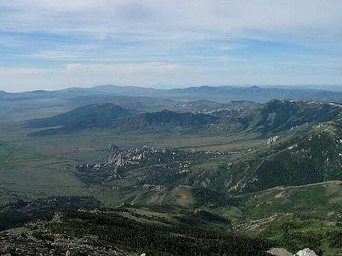
This is a dominant peak from just about every direction since it is the highest peak in the Albion Mountain range. Cache Peak has the distinction of being the highest peak in Idaho south of the Snake River and also is the highest point in Cassia county, which makes it popular with different groups of peakbaggers.Located near the famous City of Rocks National Reserve, a rock climbing mecca, Cache Peak offers a spectacular viewpoint down on this area. Cache Peak is listed at the number six spot on this list of Idaho's Fifty finest Peaks. A nearby summit, Mt. Independence is a stone's throw away from breaking 10,000 feet at 9950. SEveral alpine lakes rest on its east side, Independence Lakes. To see a map of this area, click here.
Also, for more helpful information and a ton of great climbing pics, check out the Summitpost "City of Rocks" page.
Oh, one other tidbit. Cassia county is pronounced "Cashya"
Say it like that and the locals will think you are one of them and not some out of town city slicker.
Getting There
From I-84 & Burley, take Idaho route 27 south 23 miles to the small farming community of Oakley. Go into the middle of town and take a left (east) on Main Street and go about one mile to a junction. From this point, both of the routes covered (Independence and Southwest) diverge at this fork.The left fork will take you to the Independence Lakes route, so for more information on the approach, please go to the route description for Independence Lakes.
Taking the right fork, or City of Rocks road, go to the Southwest route approach for the rest of the approach information.
Red Tape and summit visitors
We saw no signs posted that indicated a fee was necessary to either camp or park in this area. This was unchanged in 2007.
This peak gets many visitors thanks to the over 4000' of prominence and the fact tht it is the county highpoint for Cassia County. For an idea of who in the peakbagging community has climbed this one, check out this page LINK TEXT HEREat peakbagger.com
You can also find many trip reports and descriptions of many of the visits on the Cache Peak peakbagger page.
When To Climb and technical difficulty
This mountain could be done at any time of the year, snowshoed or cross country skied. in the winter spring or hiked in late spring until snow makes hiking it out of the question.It is not a technical mountain, it has a trail partway from a saddle where the forest service road ends on the southwest side so minor routefinding skills are helpful in reaching the summit, a summit that requires no scrambling skills. A map and compass would be helpful as would GPS'ing the summit coordinates so one could use that as a help.
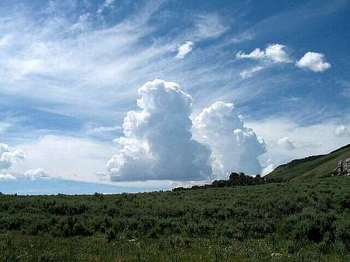
Beware of thunderstorm activity in the summer as we were chased off the mountain not long after we summitted by fast growing storm cells that literally popped out of nothing and built quickly into huge thunderclouds with activity that very afternoon.
Also, be aware that the forest service road that leads to the trail is often blocked by snowbanks into June and that a rainstorm could turn the road into a mudbath.
Camping
Camping for a fee is available at the City of Rocks area. There were no established campgrounds higher up but many places where one could camp off of the road, which is what I did my first time up there. Several nice camping possibilities within a mile or two of the saddle that the road ends at.
Mountain Conditions
No webcams are available for this area but local conditions may beobtained by calling the phone number listed below:
Sawtooth National Forest Ranger Station
3650 S. Overland Ave.
Burley, Idaho 83318
208-678-0430
The closest town of any size is Oakley Idaho.
Here is the weather report for OAKLEY . (click on Oakley)
Cassia County
Since Cache Peak is the highest point in Cassia county (pronounced Cash-ya), here is a bit of info to orient you about it. The 2000 Census showed the county had a population of 21,416 . The county seat is Burley. Albion served as county seat between 1879 and 1918. Burley is also its biggest city and has just about everything you need including a Wal Mart.Cassia County was created by the Idaho Territorial Legislature on February 20, 1879 by a partition of Owyhee County. A western portion became Twin Falls County in 1907. The county assumed its present boundaries when an eastern portion became Power County on January 30, 1913. The county was named for Cassia Creek, which in turn was named either for John Cazier, a member of the Mormon Battalion and an emigrant train captain, or for a plant found in the area. Other Cities and towns:
* Albion
* Burley
* Declo
* Malta
* Oakley

External Links
