
|
|
Mountain/Rock |
|---|---|
|
|
44.15399°N / 113.75917°W |
|
|
Custer |
|
|
Mountaineering |
|
|
Spring, Summer, Fall |
|
|
11828 ft / 3605 m |
|
|
Overview
Peak 11,828’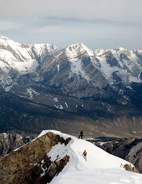 Peak 11,828' is the center point on the distant ridge. Photo taken from the summit of Mt. Corruption.
According to Tom’s Book,
Peak 11,828’ ranks as the 23rd highest in the state, but probably ranks as the #1 most overlooked. The summit is located near the end of the
North East Ridge of Mount Borah and is easily seen from the summit, but can’t compete with the jaw dropping views of the
Lost River Range to the south. (I’ve been to the top of Borah eight times and have taken photos every time. I only had one shot of 11,828 from the summit in my collection.) It’s a rarely visited summit as well, in the Lopez guide, Rick Baugher is “probably” credited with the first ascent in 1993. However, as of May 2007 the register is an old rusty peanut can, sans lid, with a scrap of paper signed by Marty Cook of Pocatello on November 19th 2005.
 Sunrise from Mount Borah. 11,828'is the dark, blocky point near the end of the North East Ridge of Borah peak.
 Getting There
Rock Creek Approach:Turn off of U.S. Hwy 93 onto Double Springs Pass road 22 miles north of Mackay or, a little less than 2 miles north of the Borah trailhead road. Drive three tenths of a mile and turn east onto Rock Creek road, follow it 3.2 miles to where it ends at an irrigation dam in the mouth of the canyon.
There are rumors about the existence of an old logging road that snakes its way several miles up the canyon and although there are signs of an old ‘small time’ logging operation, to find a road, you’ll need to spend some time with Ms. Cleo on the psychic hotline. Cross the creek at the dam and stay on the south side of the creek. Follow good game trails above the creek for most of the way.
Hike about 3 miles up the canyon and cross the creek when you are even with Mahogany creek pass, hike up onto the pass and you’ll be rewarded with a great view of Mahogany creek. The climb starts on the ridge to the south.
Ascend the mile long class 2 ridge to point 11,715 from there follow the easy class three ridge to the summit (about .7 miles)
Mahogany creek Approach: (Snow climb)
Continue over Double springs pass and turn right onto FS Road 117. Look for the Horse Haven Pass sign. Follow 117 to Horse heaven pass, continue another four miles to Mahogany creek, follow the creek to the end of the road and hike about 4 miles up to the large cirque. Depending on the conditions the climb starts at about the 10,000’ contour. Climb the obvious 40 degree snow chute to the wide saddle and finish the class 3 ridge to the summit.
 Peak 11,828 from near Mahogany creek pass. The tree on the left blocks a view of the snow chute
 North East Ridge of Mt. Borah, Point 11,715'is in the center and peak 11,828 is the high point on the other side of the wide saddle.
 Red Tape
No Red tape or permit required. camp at the Borah trailhead or at the Mahogany creek crossing. You can pitch a tent anywhere but please practice the 'Leave No Trace' ethic.External Links
Idaho Climbing GuideIdaho Summits.com
Lost River Ranger District
skunk ape - Jun 1, 2007 8:13 pm - Hasn't voted
Re: 11 FeetThanks for catching that!
kevinhansen - Jan 27, 2014 7:59 pm - Hasn't voted
Nice write upWell done. One day I'd like to run (ok walk) the ridge starting on the farthest ridge of this peak (looks like a stack of tires if looking up from Horse Haven area), then keep wandering higher and higher till I top out on Mountaineer Peak, then connect it to Borah's north east ridge.