
-
 26131 Hits
-
 89.39% Score
-
 29 Votes
|
|
Mountain/Rock |
|---|---|
|
|
43.99390°N / 113.5973°W |
|
|
Custer |
|
|
Hiking, Mountaineering, Scrambling, Skiing |
|
|
Spring, Summer, Fall, Winter |
|
|
11682 ft / 3561 m |
|
|
Overview
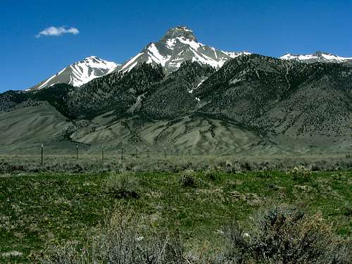
Mount McCaleb is located in eastern Idaho’s rugged Lost River Range, towards the southeast end of the main Lost River crest. It is an eye-catching mountain that is very distinctive and easily identified by its crown shaped summit block, which towers almost 6000 feet above the Lost River Valley and the small town of Mackay. At 11682’ tall, McCaleb ranks number 34 amongst Idaho’s Highest Peaks. The first known ascent of the peak occurred in 1914 by noteworthy USGS surveyor and prominent early Idaho mountaineer Thomas M. Bannon.Like the majority of peaks in the range, McCaleb is made up of crumbling limestone that makes for a laborious climb through various sections of loose scree along the way. Technical climbs have been attempted (unsuccessfully so far) on the impressive south face of the peak, but the nature of the rock makes it very challenging to place good protection. On the plus side, the rock composition has resulted in numerous cliffs and towers that help create some beautiful scenery for those who come for a visit. Because of its overall appeal, McCaleb could very well see more ascents than any other non-twelver in the range. That being said, the chance of seeing another human during a climb of Mount McCaleb is slim to none.
 Mount McCaleb, photo by Idaho Summits.
The peak is named after Jesse McCaleb who came out west from Tennessee in about 1866 after service in the Civil War. In the late 1800’s, the Mackay area saw bands of Indians, perhaps of the Bannock tribe who raided the early settlers. In the summer of 1878, during a skirmish, Captain Jesse McCaleb, was killed by a rifle shot to the head. The site where that battle took place is now covered over by Mackay reservoir, but nearby is the site of McCaleb's original burial at Battleground Cemetery. Sagebrush has reclaimed the enclosed space and scant signs remain of any individual gravesites. There is a marker that records the names of Captain McCaleb and other early pioneers. (Many thanks to BigLost for providing this history!) More details here.
Getting There
 Little Mac, Mount McCaleb, and USGS Peak.
The following directions will give you the general idea of how to reach the starting point for the hike/climb on the standard west ridge route. From downtown Mackay, turn right (northeast) on Main Street. After .4 miles, the road curves to the right and you’ll pass Mount McCaleb cemetery shortly after that. At about 1.9 miles, look for Lower Cedar Creek Road on the left heading north. From here on, there are many intersecting roads of various conditions. In general, try to catch the road that parallels Lower Cedar Creek to the mouth of the canyon. At about a half-mile from the mouth of the canyon (roughly 5.5 miles from town) take a hairpin left on a road that takes you uphill to the south briefly before heading north again. Stay on this for a half-mile (until about 6.0 miles from town) and then continue north over the irrigation ditch (you may need a high clearance vehicle for this crossing.) Later, take a road heading west (there are multiple options), and continue along the base of the mountains until you are just about due south of Little Mac (Pk 11071’). At just under 8 miles from town, your road will meet another very steep and rutted road that leaves the irrigation ditch and climbs up the mountainside for another three-quarters of a mile and 1400’ of elevation gain to a flat turnaround spot. 4WD Low is needed on this very steep road. A nice campsite is located at the end of the road (8200’ elevation, 8.75 miles from town), but you might be wise to just hike the last section instead of putting yourself and your vehicle at risk.
Camping
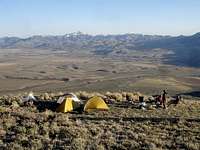 Campsite with a view.
The nearest improved camping is at Mackay Reservoir which has a tent camping area and good facilities (Picnic tables, fire ring, water, toilet.) There are flat spots to camp here and there along the approach road near the irrigation ditch, but the best site is at the end of the road at 8200’. That site provides very commanding views of the valley below, but definitely requires some committed driving to get there.
When To Climb
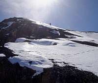
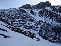
A snow free climb can usually be made from June through September. Summer is very hot in the Lost River Range, and there is no water anywhere along the route, so plan accordingly. An early season snow climb is a great option since it avoids the heat of summer, and reduces the amount of scree to contend with. Winter ascents are also possible when avalanche risk is low, with potential for ski descents on the west face of the peak.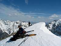 Ski Descent Ski Descent |
 West Ridge West Ridge |
 Entering the Gully Entering the Gully |
Red Tape
 Mount McCaleb, photo by IdahoKid.
No permits, parking passes, or any other kind or red tape to worry about. Just tread lightly and respect the local ecosystem.
Mountain Conditions
- Salmon-Challis National Forest - NF Current Conditions.
- Lost River Ranger District - Contact Information.
- NOAA Pinpoint Forecast – Weather.
- Idaho Outdoors Forum – Message board monitored by many local climbers.
External Links
- IdahoSummits.com Trip Report
- Dave's Trip Report
- YouTube Video of McCaleb Spring Snow Climb
- Peakbagger.com Stats
- Bivouac.com Stats
- Jesse McCaleb History
Guidebook
The following guidebook contains detailed route descriptions for Mount McCaleb and other peaks in the vicinity:
 | Idaho: A Climbing Guide by Tom Lopez – This is far and away the leading mountaineering text for the state, with a couple route suggestions for Mount McCaleb. |