
-
 43388 Hits
-
 94.72% Score
-
 49 Votes
|
|
Mountain/Rock |
|---|---|
|
|
44.01495°N / 113.65128°W |
|
|
12078 ft / 3681 m |
|
|
Overview
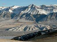
Lost River Peak stands boldly over the Lost River Valley not far from the small town of Mackay Idaho. There’s nothing gradual about this peak as it rises dramatically off the valley floor to a lofty elevation of 12078’. With this elevation, Lost River Peak ranks as the sixth highest in Idaho and is a member of the elite Idaho Twelvers group. It stands as the easternmost and southernmost Twelver in the rugged Lost River Range, home to 7 of 9 of the summits in this exclusive group. Lost River Peak ranks as the fifth highest in the range.
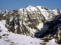
When viewed from the south, Lost River is quite distinguishable and characterized by the very defined “Super Gully” which carves its way up the southwest face of the mountain to a distinct point. However, a profile view from the east or west reveals that the summit is not made up of a single point at all. Instead, there is a ridgeline running from the false summit, which is the point visible from the south, northward for couple hundred yards to the true highpoint. From here the ridge drops a couple hundred feet or so, then rises again to a more complex and seldom visited northern summit. When viewed from the north, Lost River Peak can be seen as a complex series of ragged ridges and folds with no obvious route to ascend. However, committed scramblers can access the summit via the Dry Creek drainage and “one of the most challenging routes in the range” (Lopez pg. 283).
 |
 |
 |
Getting There
Below are driving directions to the start of the most commonly used southern routes, including the Super Gully.
- When approaching from the south, follow US Highway 93 approximately 9.5 miles north of Mackay to milepost 116 near Mackay Reservoir. (This is about 45 miles south of Challis if you are approaching from the north.)
- At milepost 116, turn east on unpaved “Upper Cedar Creek Road”.
- Follow this road for just over 3 miles until you reach an irrigation canal, which is probably the end of the line for those without high-clearance vehicles.
- You’ll encounter a few gates before getting to the canal. After passing through, please leave them as you found them.
- Take the second left (due north) after crossing the canal and follow that road almost 1 mile to the trailhead at the base of the mountain.
Access Road Update June 2022: Upper Cedar Creek Road is currently blocked by a locked gate and NO TRESSPASSING signs where it crosses the private ranch property. It’s unclear if these are new owners, or if the gate got left open one too many times. Whether or not this is a permanent closure, be prepared for an alternate drive approach. Reportedly the best option now is the next (unmarked) gate about a mile-and-a-half north off US93.
 |
 |
 |
Red Tape
There are no fees or permits required. Just observe any signs posted by local landowners and make sure to leave the gates as you found them during the drive to the trailhead.
When To Climb
There have been winter ascents of this mountain, but it is typically climbed from mid-May (after avalanche danger has lessened) through September or whenever the snow flies. The earlier in the season you climb, the less scree you will face. A great early season snow climb is popular via the super gully.
The summit register on top of Lost River Peak reflects the majority of climbers arriving in late summer; with a fair amount of others making snow climbs in June.
Camping
Camping is allowed at the trailhead, where you’ll be able to pitch a tent or two amongst the sagebrush. There may be water coming down the nearby gulch early in the year, but it generally dries up in early June or sooner.
The nearest improved camping is at Mackay Reservoir which has a tent camping area and good facilities (Picnic tables, fire ring, water, toilet.)
Mountain Conditions
Below are some good staring points for finding current conditions in the area:
- Lost River Ranger District - Contact Info for the nearest Forest Service Office.
- NOAA Pinpoint Forecast – Weather.
- Idaho Outdoors Forum – Message board monitored by many local climbers.
Other Sources of Information
Unlike many Idaho mountains, there is actually a fair amount of information available for Lost River Peak.
Guidebooks
There are at least two guidebooks that contain information on the Lost River Peak.
- Idaho: A Climbing Guide by Tom Lopez – This is far and away the premier mountaineering text for the state, with a few paragraphs devoted to Lost River Peak.

- Trails of Eastern Idaho by Margaret Fuller and Jerry Painter – Lots of detailed route descriptions for the eastern part of the state and specifics on the primary routes for all of the Twelvers, including Lost River Peak.

External Trip Reports
Here are links to a few detailed trip reports for Lost River Peak.
- IdahoSummits.com Trip Report
- IdahoAlpineZone Trip Report
- Splattski Trip Report
- Idaho A Climbing Guide Report
If you’re aware of other external links, just let me know and I will post them here.
Super Dave - Jun 25, 2022 10:33 am - Hasn't voted
Access Road Update June 2022Access Road Update June 2022: Upper Cedar Creek Road is currently blocked by a locked gate and NO TRESSPASSING signs where it crosses the private ranch property. It’s unclear if these are new owners, or if the gate got left open one too many times. Whether or not this is a permanent closure, be prepared for an alternate drive approach. Reportedly the best option now is the next (unmarked) gate about a mile-and-a-half north off US93.