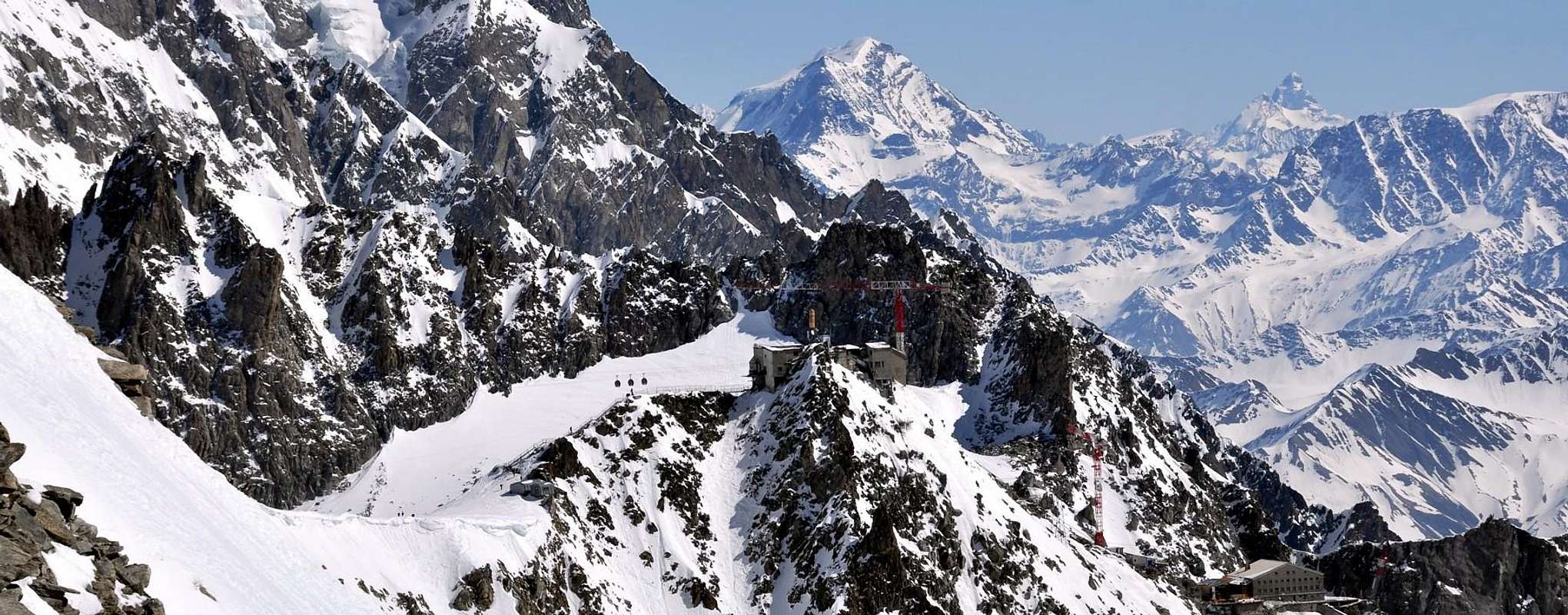
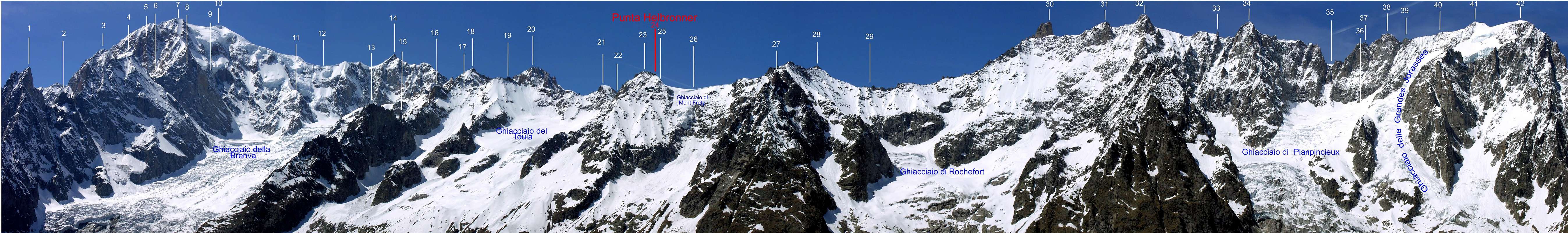
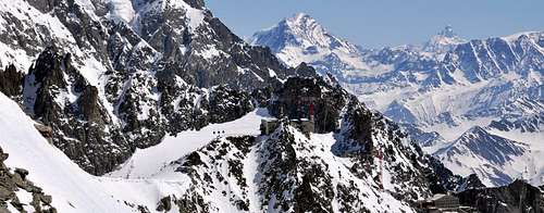
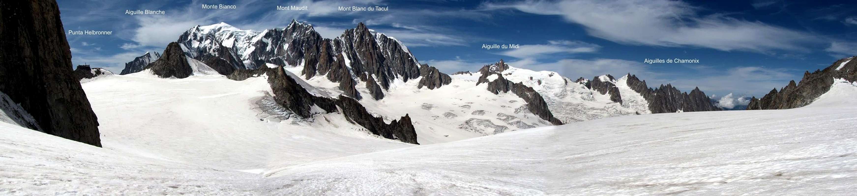
The crest of border Italy/French that, going down from the Mount Blanc to the Mont Maudit where it changes direction toward East to climb over a whole series of points, the more important of which it is the Tour Ronde (3.792m), continues therefore with course to form of arc in direction of the Grand Flambeau and, immediately later, toward Point Paul Helbronner. From this small peak the crest is flattened forming the Hill of the Giant (3.365m), wide glacial saddle, where the watershed begins that conducts to the Tooth of the Giant to the Crest of Rochefort and the six following peaks of the Grandes Jorasses. For how much it would be able, as we have just said, to appear to small summit, if analyzed in his impending terminal part the two Refuges Torino (Old and New), in reality introduces to great rocky mass, that of the same one belongs, that falls toward Midday. The Point Helbronner in fact topographical point becomes enough remarkable sending toward South a great rocky buttress, such to separate the two glacial basins of the Glacier des Thoules to West from the minuscule Glacier du Mont Fréty, in the opposite side; in turn the same bastion divides him in two ramifications, of which a revolt to South, that finishes to the quota 2.701 meters and the Southeast second toward Les Portes (2.727m) to quota 2.432 meters. On his Summit to station of the "Funivia of the Glaciers" or octave it exists wonder of the world (as in the advertising placards), that from Courmayeur through flight across on the Blanc's Chain transforming itself from cable railway to cableway with small nacelles that connect Point Helbronner with the Aiguille du Midi, maximum elevation of the whole crossing (3.842m). From the same he goes down with to "flight" dizzy to Le Pra Conduit in the Valley of Chamonix. This the principal motive for the scarce popular mountaineers presence on the mountain, posts "to horse" among the Pass of the Giant and the Col de Saussure (3.428m), that separates it from the Grand Flambeau (3.566m). Good panoramic point on the whole Chain of the "Bianco" and particularly on the notorious Wall of the Brenva with in profile the Pylons of the Freney; exceptional glimpse on the Aiguille Noire de Péuterey.
La cresta di confine Italia/Francia che, scendendo dalla Vetta del Bianco al Mont Maudit dove cambia direzione verso Est per scavalcare tutta una serie di punte, la più importante delle quali è la Tour Ronde (3.792 m), prosegue quindi con andamento a forma di arco in direzione del Grand Flambeau e, subito dopo, verso Punta Paul Helbronner. Da questa piccola vetta la cresta si appiattisce formando il Colle del Gigante (3.365 m), larga sella glaciale, dove inizia lo spartiacque che conduce al Dente del Gigante, alla Cresta di Rochefort ed alle sei successive vette delle Grandes Jorasses. Per quanto potrebbe, come abbiamo appena detto, apparire una piccola sommità, se analizzata nella sua parte terminale sovrastante i due Rifugi Torino (Vecchio e Nuovo), in realtà presenta una grande massa rocciosa, facente parte della medesima, che cade verso Mezzogiorno. La Punta Helbronner infatti diventa punto topografico abbastanza rilevante inviando verso Sud un grande contrafforte roccioso, tale da separare i due bacini glaciali del Glacier des Thoules ad Occidente dal minuscolo Glacier du Mont Fréty, nel lato opposto; lo stesso bastione a sua volta si divide in due ramificazioni, delle quali una rivolta a Sud, che termina alla quota 2.701 m, e la seconda a Sudest verso Les Portes (2.727 m) a quota 2.432 m. Sulla sua Sommità esiste una stazione della "Funivia dei Ghiacciai" od ottava meraviglia del mondo (come nei cartelloni pubblicitari), che da Courmayeur trasvola la Catena del Bianco tramutandosi da funivia in ovovia con piccole navicelle tali da congiungere Punta Helbronner con l'Aiguille du Midi, massima elevazione dell'intera traversata (3.842 m). Dalla medesima si scende con un "volo" vertiginoso a Le Pra Conduit nella Valle di Chamonix. Questo il motivo principale della scarsa frequentazione della montagna, posta a cavallo tra il Colle del Gigante ed il Col de Saussure (3.428 m), che la separa dal Grand Flambeau (3.566 m). Ottimo punto panoramico su tutta la Catena del Bianco ed in particolare sulla famigerata Parete della Brenva con in profilo i Piloni del Freney; colpo d'occhio eccezionale sulle Aiguille Blanche e Noire de Péuterey.
The Octave Wonder of the world/L'Ottava Meraviglia del Mondo
The "Funivia" (Cableway) that, with three lists and disconnected sections, altogether of 15 Kilometers around (preciseness inaugurated in the Summer of 1947 and completed in the Sixties with his six stumps), colleague the famous tourist centers of Courmayeur in Italy and Chamonix-Mont Blanc in France and vice versa he has been built in the fifties with an enormous massive structure of job. The same allows a magic crossing of the Chain of the Mount Blanc on the axle Sud/Nord with two important topographical knots, that constitute besides the more fundamental points of relief: the Peak of Point Helbronner on the crest of border and that of the Aiguille du Midi, maximum elevation of the journey, completely in France and to the beginning of the imposing Chain of the Aiguilles de Chamonix that finishes toward North with the Aiguilles du Grépon (3.482m) and of Grand Charmoz (3.445m).
DESCENT CABLEWAY VIEW to AIGUILLES of CHAMONIX
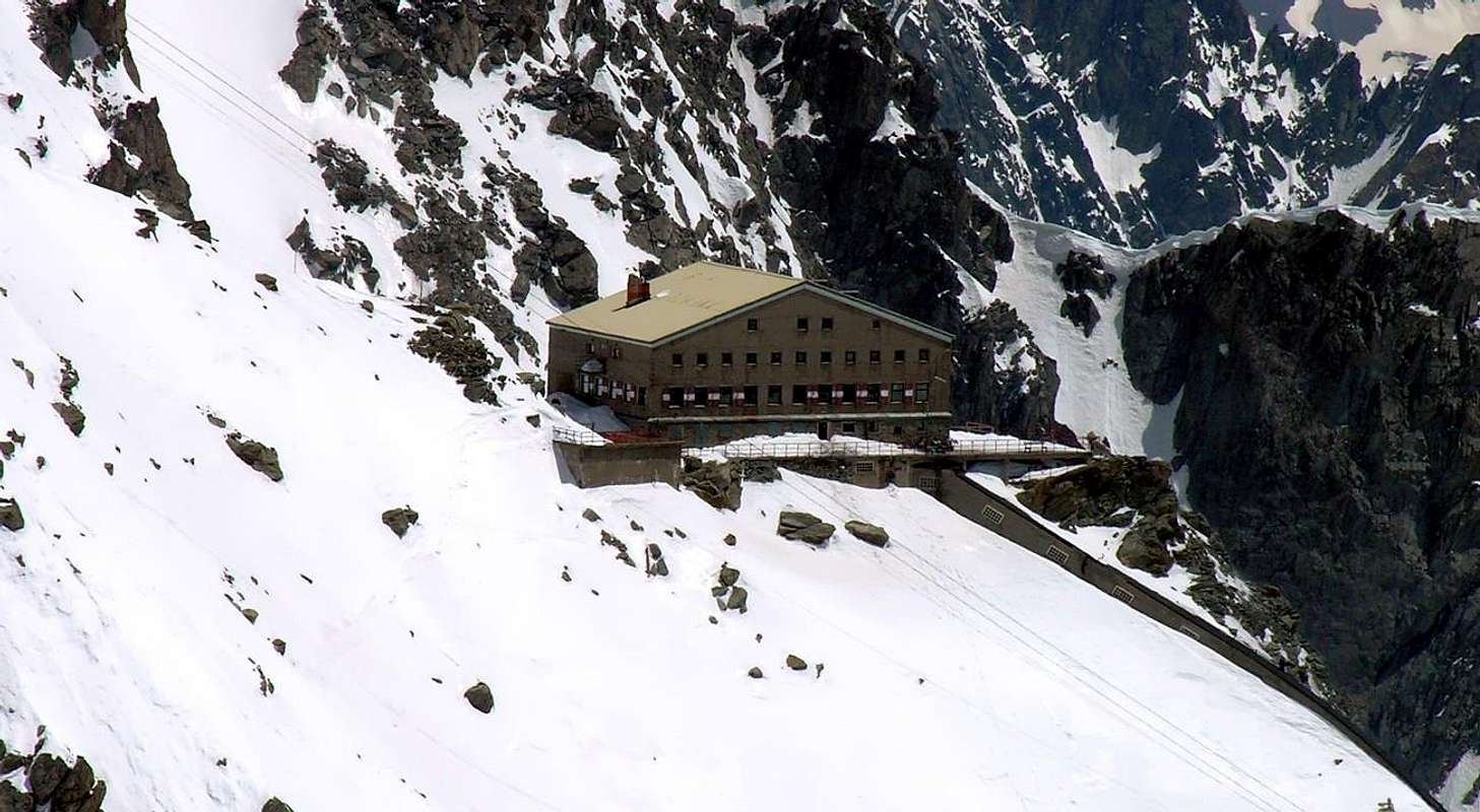
The construction of the same one has completely overturned the way of drawing near to the peaks of the Mount Blanc in the district among the two Shelters Turin in Italy as soon as below the Pass of the Giant and the Refuge des Cosmiques to the homonym Hill, situated among the Aiguille above quoted and the great mass of the Mont Blanc du Tacul (4.248/9m).
La Funivia che, con tre distinte e staccate sezioni, complessivamente di 15 Km circa, (per precisione inaugurata nell'Estate del 1947 e completata negli Anni Sessanta con i suoi sei tronconi), collega i rinomati centri turistici di Courmayeur in Italia e Chamonix-Mont Blanc in Francia e viceversa é stata costruita negli Anni Cinquanta con un'enorme mole di lavoro. La stessa permette una magica traversata della Catena del Monte Bianco sull'asse Sud/Nord con due nodi topografici importanti costituenti inoltre i punti di rilievo più basilari: la Vetta di Punta Helbronner sulla cresta di confine e quella dell'Aiguille du Midi (3.842 m), massima elevazione del tragitto, completamente in Francia ed all'inizio dell'imponente Catena delle Aiguilles de Chamonix che termina verso Settentrione con les Aiguilles du Grépon (3.482 m) e del Grand Charmoz (3.445 m).
La costruzione della medesima ha completamente sovvertito il modo di appropinquarsi alle vette del Monte Bianco nel comprensorio tra i due Rifugi Torino in Italia appena al di sotto del Colle del Gigante ed il Refuge des Cosmiques all'omonimo Colle, situato tra l'Aiguille succitata e la grande massa del Mont Blanc du Tacul (4.248/9 metri).
New Works of Cableway on Helbronner Point
Currently a project sees in work the reconstruction of the same one that will be therefore dam to the public beginning from next nine April 2012 and that he should end himsel with the term of the jobs among 2015 and 2016. He remains, however opened the stump that climbs up to the Old Shelter Turin, where a path panoramic door to the New one from which easily and shortly time the near Hill of the Giant can be reached. In the same it is anticipated lun job of restructuring of the Peak of Point Helbronner with the "restailing" of the intermediary station, before the crossing with the "nacelles" of the Mer de Glace in direction of the Peak of the Aiguille du Midi (3.842m). It will again be besides installed the Museum of the Crystals "Hans Marguerettaz" (momentarily transferred currently to the Pavillon (2.174m) at the end of the first stump I approach the homonym shelter; you see under immediately in the following section) with amazing and such jobs to be constituted a further wonder in the wonder.
Attualmente un progetto vede in opera la ricostruzione della medesima che sarà quindi chiusa al pubblico a partire dal prossimo nove Aprile 2012 e che dovrebbe concludersi con il termine dei lavori tra il 2015 ed il 2016. Rimane, comunque, aperto il troncone che sale fino al Vecchio Rifugio Torino, dove un sentiero panoramico porta al Nuovo dal quale facilmente ed in breve tempo si può raggiungere il vicino Colle del Gigante. Nello stesso é previsto un lavoro di ristrutturazione della Vetta di Punta Helbronner con il "restailing" della stazione intermedia, prima della traversata con le "navicelle" della Mer de Glace in direzione della Vetta dell'Aiguille du Midi (3.842 m). Sarà inoltre nuovamente installato il Museo dei Cristalli "Hans Marguerettaz" (attualmente trasferito momentaneamente al Pavillon (2.174 m) al termine del primo troncone appresso l'omonimo rifugio; vedi subito sotto nella seguente sezione) con lavori strabilianti e tali da costituire un'ulteriore meraviglia nella meraviglia.
CRYSTALS MUSEUM
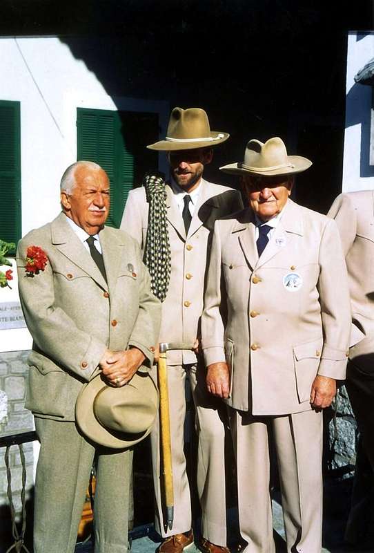
From an old Idea-project intuitively by the Count Giovanni Battista also called, for the Friends of Courmayeur Town, "Titta" Gilberti Years Ninety that had involved in 1994 the strong Alpine Guide of Courmayeur Hans Marguerettaz (fallen in August 21th, 1994 with the glider near the Southern Slope of the Mont Tantané in Valtournenche) beginning from the end of the Nineties he has been prepared in Peak to Point Helbronner a Museum of the Crystals with the exposure of the mineralogical wonder of the Crystals of the Mount Blanc, named and dedicate to the same mountaineer. Initially in the first season of the exposures it coparticipated had the Mineralogical Museum in Turin, with to series of small pyramids in glass to the center of the saloon, while on the perimeter walls happened an the unfold of mineralogical champions of two known seekers of crystals of Aosta Town. As a matter of fact to bring forth the sketch of Hans they have to arrange his two friends Seekers of Mineral Camillo Roberto Ferronato & Franco Lucianaz, both mountain climber of the Commune of Charvensod and respectively in the Fractions of Pian Felina and Valpettaz, surely among the most famous researchers not only in Italy, but besides in Europe (you see in My Albums of SPCRYSTALS OF THE MONTE BIANCO). So that the end in the Summer of 1997 and actually to last Autumn 2011 in the Saloon built near the Peak of Point Helbronner have been possible to admire the open wonder and had recovered since two tireless and impassioned "Hunters of Crystals" or, to tell it the Frenchwoman, Chrystalliers (Jacques Balmat in first ascent of the "Bianco" was also it in the August of 1786 and all the ancient guides both of Chamonix that of Courmayeur); the necessity of the remaking of the "Funivia dei Ghiacciai" he has currently done him that the same one he has moved to the Pavillon Refuge to an analogous room of exposure waiting for a future restoration, at the end of the same ones, on the Point Helbronner, where anticipated anything is of really grandiose.
Da una vecchia Idea-Progetto intuita dal Conte Giovanni Battista, e per gli Amici di Courmayeur, "Titta" Gilberti Anni Novanta che aveva coinvolto nel 1994 la forte Guida Alpina di Courmayeur Hans Marguerettaz (caduto il 21 di Agosto del 1994 con l'aliante nei pressi del Versante Meridionale del Mont Tantané in Valtournenche) a partire dalla fine sempre degli Anni Novanta é stato allestito in Vetta a Punta Helbronner un Museo dei Cristalli con l'esposizione delle meraviglie mineralogiche dei Cristalli del Monte Bianco intestato e dedicato al medesimo. Inizialmente nella prima stagione delle esposizioni aveva compartecipato il Museo Mineralogico di Torino, con una serie di piccole piramidi in vetro al centro del salone, mentre sulle pareti perimetrali avveniva un dispiego di campioni mineralogici di due noti cercatori di cristalli aostani. Infatti a portare avanti il disegno di Hans hanno provveduto i suoi due amici Cercatori di Minerali Camillo Roberto Ferronato e Franco Lucianaz, entrambi alpinisti del Comune di Charvensod e rispettivamente nelle Frazioni di Pian Felina e Valpettaz, sicuramente tra i più famosi ricercatori non solo in Italia, ma inoltre in tutta Europa (vedi in My Albums sempre in SPCRYSTALS OF THE MONTE BIANCO) dalla fine dell'Estate del 1997 e sino allo scorso Autunno 2011 nel Salone costruito presso la Vetta di Punta Helbronner é stato possibile ammirare le meraviglie scoperte e recuperate da questi due accaniti ed appassionati "Cacciatori di Cristalli" o, per dirla alla francese, Chrystalliers (lo era pure Jacques Balmat primo salitore del Bianco nell'Agosto del 1786 e tutte le antiche guide sia di Chamonix che di Courmayeur); la necessità del rifacimento della "Funivia dei Ghiacciai" ha fatto si che il medesimo attualmente é stato trasferito al Rifugio del Pavillon in un'analoga sala d'esposizione in attesa di un futuro ripristino, al termine dei medesimi, sulla Punta Helbronner, dove é previsto qualche cosa di veramente grandioso.
Keepers of a gambling house of the Minerals Hunters "DUDES TRIO" 2011
First Ascents
First in the summit: Unknown.
In winter: Unknown.
Getting There
BY CAR:
From Torino, Milano, etc: Motorway A5. Exit at Morgex.
From Switzerland: through the Grand St. Bernard Tunnel or the homonym pass.
From France: through Mont Blanc Tunnel or Petit St. Bernard Pass.
BY PLANE:
Aeroporto "Corrado Gex" Saint Christophe (Aosta).
ACCESS FROM COURMAYEUR (La Palud) PUNTA HELBRONNER:
From A5 Morgex toll drive along the SS.26 toward Courmayeur, cross it and once in Entréves follow for the Village La Palud - car parking car parking - Funivies of the Monte Bianco.
Dall'uscita dell'Autostrada A5 nel comune di Morgex (921 m) proseguire lungo la SS.26, verso il Paese di Courmayeur (1.228 m) e, raggiunta la Frazione di Entrèves/La Palud (1.370 m), parcheggiare l'auto nel parcheggio delle "Funivie del Monte Bianco".
Route
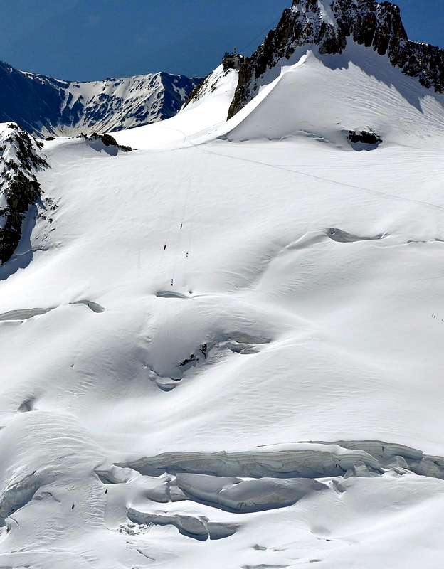
From the two Refuges Torino at Giant's Hill, "the Italian door to Vallèe Blanche and Mont Blanc massif", (attainable from village La Palud of Entreves, with the cableways of the Monte Bianco), walk toward NW bordering on easy glacier up to the de Saussure Hill (3.428m). Follow the watershed ridge Northwestern, that in little more than 130m, leads to the summit. Another route: on the right, along the South-southeast Face climbing, enough easily, on slope with rotten and broken rocks and debris; moreover through the moderate snowy-icy Northern Slopes in French side. Descent along the same routes.
Dai Rifugi Torino al Colle del Gigante, "porta d'ingresso" italiana alla Vallée Blanche ed al massiccio del Monte Bianco (raggiungibile dalla frazione La Palud di Entreves, con le funivie del Monte Bianco), costeggiare con direzione NW e con percorso facile su ghiacciaio raggiungere il Colle de Saussure (3.428 m). Dal colle seguire la Cresta Nordovest spartiacque che, con poco più di un centinaio di metri, porta alla sommità. Si può risalire anche più a destra sul Versante Sud-sudest seguendo abbastanza facilmente un pendio di rocce rotte e detrito; oppure sul versante francese attraverso, con moderata pendenza, glacio-nevati. Discesa lungo la via di salita.
Difficulty
Difficulty: from F to F+.
Difficoltà: da F a F+.
Gear
Mountaineering equipment, including rope, helmet, iceaxe, and crampons.
Da alta montagna, corda, casco, picozza e ramponi.
When To Climb
The period from mid June to mid September usually offers the best conditions. The rock climbs would be substantially more challenging off season.
Huts
Rifugio Torino (3.329-3.375m) Tel.: Nuovo numero telefonico +39 3402270121 Cell. Gestore +39 3356184758 Funivie Monte Bianco +39 016589925
Red Tape
No permits are required and no fees must be paid to climb Grand Flambeau. Since it is on the Italian-French border, carry some means of identification.
Campings
Remember that free camping is forbidden (except for emergency reasons, over 2.500m, from darkness until dawn).
Mountain Conditions
You can get meteo information at the official site of the Regione Valle d'Aosta:
Parents refers to a larger category under which an object falls. For example, theAconcagua mountain page has the 'Aconcagua Group' and the 'Seven Summits' asparents and is a parent itself to many routes, photos, and Trip Reports.

 18698 Hits
 83.1% Score
 16 Votes