
|
|
Mountain/Rock |
|---|---|
|
|
39.52665°N / 105.82251°W |
|
|
Mountaineering |
|
|
Summer |
|
|
12801 ft / 3902 m |
|
|
Overview

To the north, the Red Cone is connected to Unnamed Peak 13214 ft which rises above the 12096 ft Webster Pass. To the south, the Red Cone’s long and gentle ridgeline separates Handcart Gulch to the west from Geneva Creek to the east (both minor branches of the South Platte River).
The Red Cone can be accessed via Webster Pass Road which is a 21 mile long Four Wheel Drive road that goes from the town of Montezuma to the north to the town of Webster on U.S. Route 285. From Montezuma (10300 ft), the road follows Snake River up a beautiful wide valley to tree-line at around 11400 ft. It then makes a series of switchbacks to reach the 12096 ft Webster Pass. Immediately south of the Pass, the road becomes very narrow and drops to the bottom of the Handcart Gulch via a few switchbacks and then follows the gulch to the town of Webster.
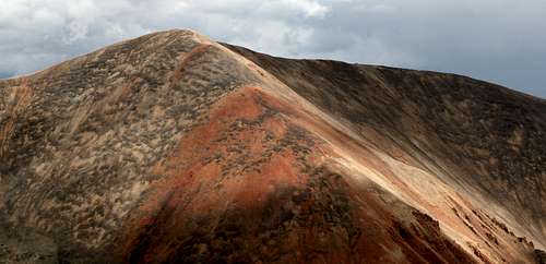
A much rougher branch of the Webster Pass Road goes all the way to the summit of the Red Cone. This road branches off Webster Pass Road in Handcart Gulch and then follows the top of the Red Cone’s southern ridgeline to reach its summit where it can be continued down a couple of extremely steep sections to Webster Pass (see map). The first steep section is directly to the north of the Red Cone’s summit. Here the road drops straight down the slopes from the 12801 ft summit to a 12580 ft saddle (see picture). The second steep section goes directly down the slopes of Point 12399 ft to the 12096 ft Webster Pass (see picture). These steep sections make the Red Cone Road one way from the summit to Webster Pass (This of course applies only to vehicles. Hikers can obviously follow the road in any direction). (For more information about driving the road see “External Links” below).
For a good hike, I suggest that you drive the Webster Pass Road from Montezuma to the beginning of the switchbacks (Passable by most/any 4WD vehicle) and then hike the road to the top of the Red Cone (2.25 miles, 1400 ft vertical). Patches of snow block the higher portions of the road to drivers until mid August. On weekends in late August and in September, you are likely to share the mountain with a few people in Jeeps or on ATVs. Please be ware that driving this road is dangerous and requires much experience. The steep sections of the road were at times even too slippery to hike. You could easily tip your vehicle over.
Getting There
Take Exit 205 off of I-70 to Route 6 and drive less than 10 miles southeast to the town and ski resort of Keystone. On the east end of Keystone, you will see a sign for Montezuma Rd (When I first drove into Keystone from the east/Loveland Pass, I did not see any signs for Montezuma Rd. I do not think there is any access to Montezuma Rd from westbound Route 6. The access seems to be only from eastbound Route 6. Please correct me if I am wrong). Drive the road a few miles to the end of pavement at the town of Montezuma which is nothing more than a few homes.Go to the south end of Montezuma and drive the well graded dirt road 0.9 miles until you see the a sign for Webster Pass (Forest Road 285). Turn left onto this road. 4WD starts here but the road was not too bad and you might even be able to drive a good chunk of it without 4WD. Follow the road through a pine forest. At 2.4 miles from Montezuma you will reach a creek crossing. In early September the water was no more than a foot or so deep. Earlier in the season, the water can of course be deeper making the crossing difficult. Continue the road until 3.6 miles from Montezuma where you will reach the beginnings of the switchbacks (11400 ft).A road here goes to the right to Radical Hill. For Webster Pass, turn left. I chose to park here and hike the rest of the road.
The road actually seemed to remain of the same difficulty until Webster Pass. South of the pass the road seemed to become narrow and scary but I did not go there.
Red Tape
No fees/permits needed. For questions call Dillon Ranger District Office (970)468-5400.External Links
Good information about the Webster Pass, Red Cone and many other 4 Wheel Drive roads in Colorado can be found in the book: "Guide to Colorado Backroads & 4-Wheel Drive Trails" by "Charles A. Wells".Click here for a link to a good site about the Red Cone Road.
Click here to see pictures of a vehicle that rolled off of Webster Pass Road.