
-
 423 Hits
-
 79.78% Score
-
 11 Votes
|
|
Mountain/Rock |
|---|---|
|
|
67.88819°N / 12.98884°E |
|
|
Nordland |
|
|
Hiking, Mountaineering, Scrambling |
|
|
Summer |
|
|
1608 ft / 490 m |
|
|
Overview
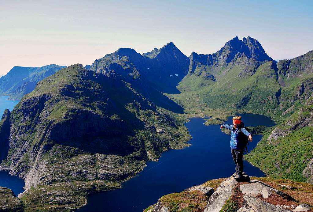
Tindstinden 490 m
Tindstinden is a beautiful coastal peak overlooking the Norwegian Sea and located on the South-Eastern sector of Moskenesøy, an island belonging to the Lofoten archipelago. Apart from the very small Værøy, isolated and far from the remaining islands of the archipelago, Moskenesøy is the Southernmost of all Lofoten and is made up of a scenic and sharp chain of rocky peaks emerging from the sea, separated by spectacular fjords and lakes.
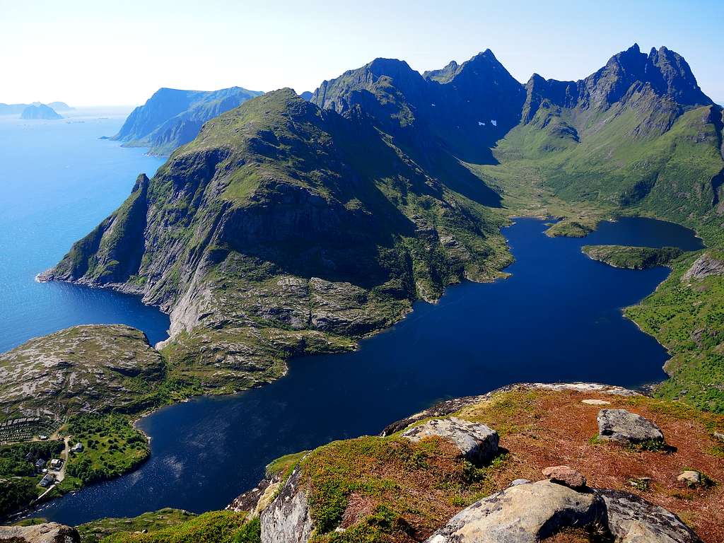
This superb summit can be summited with a fine scramble including a spectacular panorama over Å i Lofoten and Lake Agvatnet. Neverthless it's required to take care as the itinerary, although not difficult, is recommendable only to experienced hikers. In fact, a certain habit of exposure is needed and above all a good experience to predict when the itinerary is free of snow.
Getting There
Road access
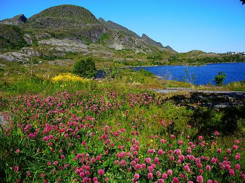
Coming from Reine (from the North) along the E10 reach Sørvågen, cross the center and about 400 meters after the grocery store on the right, turn right along a road that leads to a paid car park. After a few hundred meters, there is a fork on the road, turn right and you will arrive at the parking lot.
Tindstinden standard route
Tindstinden Normal Route report
Summit altitude: 490 m
Difficulty: Easy scramble, some steep and exposed (but brief) sections
Vertical gain: 450 m from the parking lot
Exposure: W
Starting point: parking lot near Sørvågen, Moskenesøy
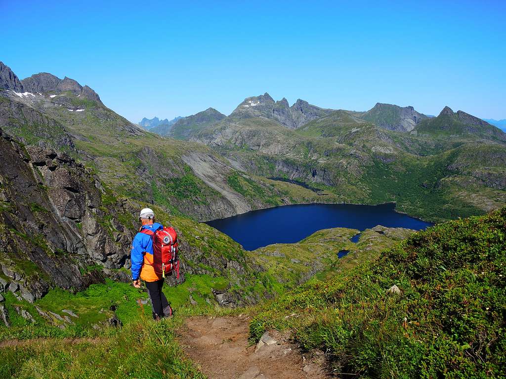
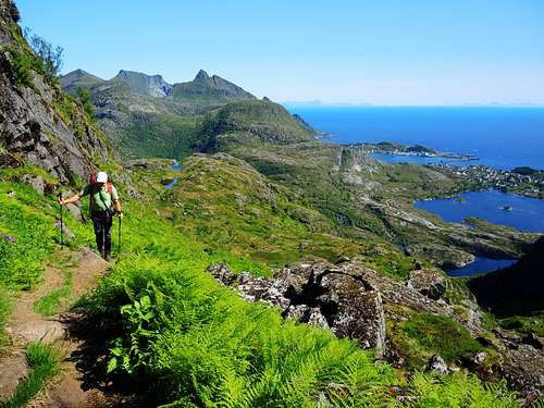
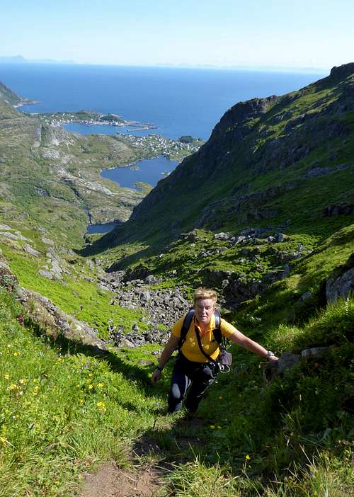
A very interesting and panoramic route to enjoy exciting views over the fjords and the majestic granite peaks all around Å i Lofoten
The parking lot is the starting point of our itinerary, which for the first stretch is in common with the Munkan (Munkebu). Near the building, located at the end of the parking area, take an obvious path that runs alongside the Sørvågvatnet (on the right) and runs along some flat granite slabs. At the first crossroads, leave the path that goes around the lake on the right and continue straight, arriving under a group of small waterfalls. After crossing a stream on the right, head up to the left towards the large lake known as Stuvdalsvatnet.
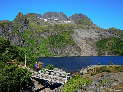
Once you reach a flat stretch, leave the path to the refuge Munkebu on the right and take a track on the left that shortly leads to a small wooden bridge that allows you to cross the outlet of Lake Stuvdalsvatnet.
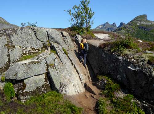
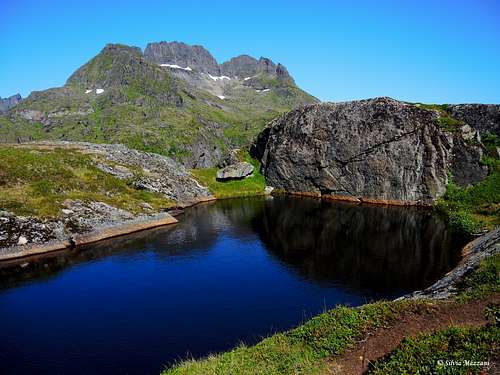
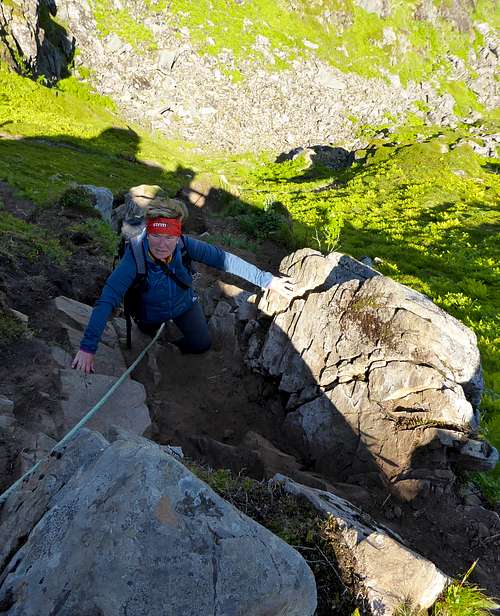
Our route thus forks from that of the Munkan. After the crossing, continue straight and begin to climb up a large ridge (don’t take the path to the right along the lake). You then reach a small shelf, from where you descend a steep rocky step with the help of a short steel cable. After a slab assisted by another metal cable, you continue to climb the slope and reach a highpoint at about 250 meters with a summit box. You cross an area dotted with countless lakes and at the end of the wide ridge turn left into a valley set between granite walls. The valley, closed at the top by a serrated rocky ridge, will lead you to a narrow saddle.
You start to go up the valley dotted with ferns along the right side.
About halfway through the valley there are two possibilities: a track slanting left, less steep, and a direct itinerary climbing up a narrow and very steep gully among the lush ferns and reaching the narrow notch along a rocky ridge.
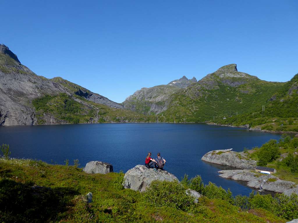
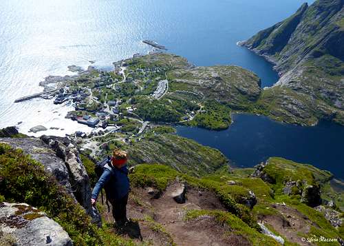
At the saddle, where an extraordinary view of the lake Ågvatnet opens up, you will see a little path on the left which will lead you to the summit. Turn sharply left and start walking along this little path running alongside the rocky ridge and equipped with some fixed ropes at the beginning, with a steeper stretch about halfway.
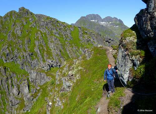
Still on rocky terrain, proceed alternately to the right and to the left of the ridge. A few more rocks, some turns, and you’ll reach the summit cairn.
The view is extraordinary over the sea that laps the nice village of Å i Lofoten, the majestic granite peaks all around and the magnificent lake Ågvatnet!
Descent: reversing the same route
Red Tape
There are no particular restrictions in climbing and hiking.
Climate
On Lofoten the weather can change suddenly from clear and blu sky with sunshine or the Northern Lights (Aurora Borealis) to violent storms with rain or snow. Maximum temperatures go from +30°C in June and July to -15°C in January and February; the average temperatures for these months are from +12°C to -3°C. The period with the minimum rainfall goes from April to June, while we may expect the maximum rainfall or snowfall between October and December.
Midnight sun: from 27 May to 17 July Polar night: from 6 December to 6 January
The Northern Lights can be seen over Lofoten from September to April.
Useful info about climate: Meteorologisk Institutt
| Month | Avg Low | Avg High | Precipitation (mm) | Wet Days | Daylight (Hours) |
| January | -2°C | 1°C | 65 | 18 | 5 |
| February | -2°C | 1°C | 60 | 17 | 10 |
| March | 0°C | 3°C | 65 | 18 | 14 |
| April | 1°C | 5°C | 55 | 17 | 20 |
| May | 5°C | 9°C | 55 | 18 | 24 |
| June | 7°C | 12°C | 70 | 18 | 24 |
| July | 9°C | 15°C | 65 | 18 | 24 |
| August | 8°C | 15°C | 90 | 20 | 22 |
| September | 7°C | 13°C | 100 | 22 | 15 |
| October | 5°C | 8°C | 110 | 23 | 10 |
| November | 3°C | 6°C | 85 | 19 | 6 |
| December | -1°C | 3°C | 75 | 19 | 2 |
When to Climb
Best months to climb are June, July and August
Midnight sun: from 27 May to 17 July
Polar night: from 6 December to 6 January
Accomodation
In the island of Moskenesøy and surroundings there is a wide choice of different kinds of accommodations: hotels, campgrounds and the traditional and typical rorbuers, the Norwegian fishermen's cabins. In Norway free camping is allowed in every place, if not expressly forbidden.
Meteo
Guidebooks and maps
"Hiking the Lofoten Islands" - David Souyris, Magdalena Brede - 60 day hikes and a Trek across the archipelago, 2017