
-
 32860 Hits
-
 93.58% Score
-
 43 Votes
|
|
Mountain/Rock |
|---|---|
|
|
68.17910°N / 14.22880°E |
|
|
Nordland |
|
|
Hiking, Mountaineering, Trad Climbing |
|
|
Summer |
|
|
1936 ft / 590 m |
|
|
Overview
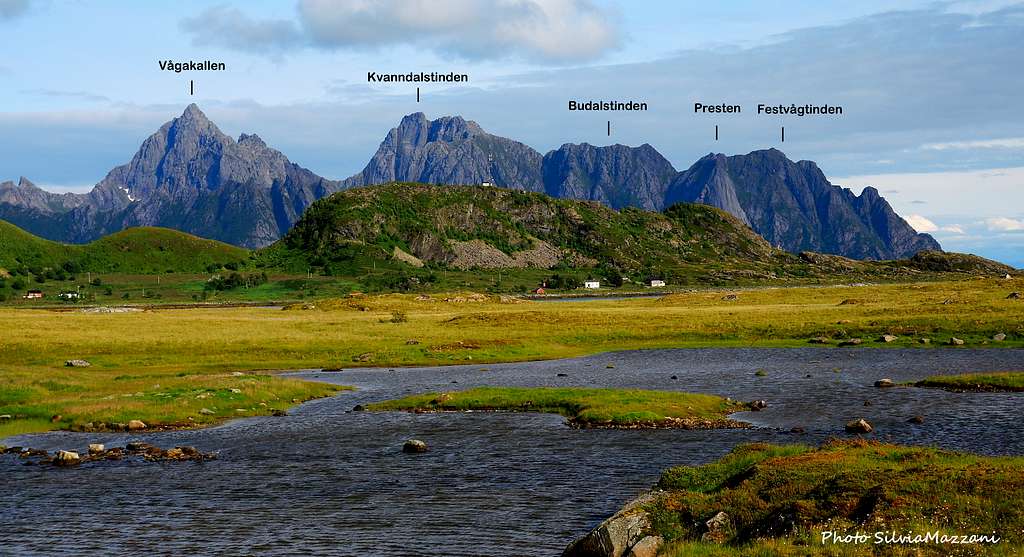
Presten 590 m
“Deep, placid fjords, jagged rocky peaks, a historic and geologic masterpiece” - National Geographic, September 2007
These ones are the best words to define Lofoten i’d ever heard!
The Lofoten archipelago, including five big and five smaller islands, lies off Norway's Northern coast, West to Narvik and about 200 km North to the Polar Arctic Circle. These breathtaking islands offer a wide choice of granite rock-climbing as well as winter mountaineering, ski-mountaineering and summer scrambling. Surely Lofoten islands are one of the most charming climbing area in the world: to climb on these cliffs gives exciting sensations and unspeakable views over a unique seascape. Notwithstanding their moderate altitude – the highest mountain, Higrattinden, is only 1116 m. high - these peaks are truly extraordinary.


Presten (The Priest) is surely one of the best known cliffs on Lofoten: a majestic 400 m granite bulk straight up from the ocean, situated close to Henningsvær, a charming village nicknamed “Lofoten’s Venice” in the South-Western end of Austvågøy, Lofoten’s largest island (Vågan Municipality). Presten unmistakable outline overlooks with its famous granite “Nose” the coastal road running to Henningsvær, giving unforgettable views when seen from here. A great number of routes run on its West face, but the classic one is Vestpillaren (West Pillar). This is the original route of the face, climbing a system of corners and cracks on the right hand side of the "Nose".
Getting There
Getting to the Lofoten archipelago
There are various possibilities:
- By car from Evenes Airport to Svolvær
- By ferry boat from Skutvik to Svolvær or Skrova (North of Lofoten)
- By ferry boat from Bodø to Moskenes, Værøy or Røst (South of Lofoten)
- By plane from Bodø


Getting to the Presten
It's possible to get to the cliff directly from Svolvær, Lofoten major center, in about 20 km along the E10 road and also from Kabelvåg, in about 15 km. along the E10, turning to left to Henningsvær (Road 816) at E10 and Road 816 junction. Otherwise the shortest way to approach the cliff is from Henningsvær (less then 5 km.), or from Lyngvær (less then 5 km), a good place along the E10, about 20 km. West to Svolvær.
History
The climbing on Lofoten began in the year 1889, when two local fishermen realized the first ascent of Vagakallen. At the beginning of last century some British alpinists, and mainly William Slingsby, started to climb in the islands. On 1910 a Norwegian party (C.W. Rubenson, A.B. Bryn, F. Schjeldrup ) climbed Svolvær Geita (Svolvær Goat) – a peak overlooking Svolvær - in first ascent.


Successively the Lofoten were mainly visited by Norwegian and British team. On the Sixties, the Nesheim brothers from Tromso and the local Arild Meyer realized the first ascent of some hard routes, like Vestpillaren on Presten and Great Pillar on Vagakallen, while H.C. Doseth climbed Vestpillaren all free climbing for the first time. In the last years mainly Norwegian and USA teams, Ed Webster between these latter, realized several first ascents of big walls.

Presten climbing routes overview
Presten climbing routes from left hand to right hand - Norwegian Scale
- "Himmel og Helvete" (Heaven and Hell) - 7, 560 m.
- "To krigere" (Two Warriors) - 7, A3
- "Korstoget" (The Crusade) - 7, 385 m.
- "Ypperstepresten" (The High Priest) - 6, 160 m + 60 m. across Storhylla
- "Biskopen" (The Bishop) - 6-, A0 220 m. + 60 m. across Storhylla
- "The Codfather" - 7, 465 m.
")

- "Sondagskole turen" (Sunday School Outing) - 7, 170 m.
- "Reisen" (The journey) - 7+, 440 m.
- "Vestpillaren Direct Start" (The West Pillar) - 6, 470 m.
- "Vestpillaren Original Start" - 6, 450 m.
- "Himmelen kan vente" (Heaven Can Wait) - 6+, 310 m.
- "Klokkeren" (The Bell Ringer) - 7-, 450 m.

Other climbing info here: ukclimbing.com/logbook/crags/presten-1938
Descent
Not a problem. The descent is substantially easy and requires 2 hours. From the summit heads towards East, then scramble along a ridge, gaining a rocky saddle between Festvågtinden (541 m.) on the right and Budalstinden (663 m.) on the left. From here there are two different descent ways:
- from the saddle cross the ridge and briefly dowmclimb to gain a steep vegetated gully, with enormous ferns, dropping to the North-East. Follow it to its end, then traverse West (right) along blocks and grass, reaching the beautiful water-mirror of Heiavatnet, the ancient Henningsvær water reservoir. From the lake a well worn and steep track leads to Festvag, on the coast road between the parking below Presten and Henningsvær
- from the saddle follow the ridge towards right (easier but longer) to the Festvågtinden, reaching the path that descends to Heiavatnet. From the lake here same track to the road as the previous point
Hiking and scrambling


This itinerary, as well as being the descent route for who have climbed the Presten West wall, is a nice tour that allows you to reach the small lake named Heivatnet and the summit of Festvågtinden. The trail starts from Festvag, on the coast road, close to Henningsvær; a well worn path rises to the beautiful small lake named Heiavatnet, the ancient Henningsvær water reservoir. From the lake a path heading left leads to the top of Festvågtinden m. 541, a peak close to Presten (2 hours and a half from Festvag), or otherwise, by an easy scramble on the summit crest, to the top of Presten.
Red Tape
No particular restrictions in climbing and hiking

The surroundings


")
When to climb
Lofoten are famous for their weather conditions, which sometimes can be a bit "a lottery", though sometimes “High Scandinavian” and “Gulf Stream’s” warming effects can give you blu sky and sunshine. However best months for climbing are late May, June, July and August.
Where to stay

Camping
In Norway camping is allowed in every place, if not expressly forbidden. Best free campsites in this area are located in Festing, in front of the Gandalf cliff, and Paradiset, just close to Henningsvaer. The nearest equipped campsite is the Lyngvaer Bobilcamping (campers, tents and cabins), 20 km. West to Svolvær and strictly close to the E10 - R816 road forking, a few kilometers from Presten. Another campsite is “Sandvika”, between Svolvær and Henningsvær, and the nearby Orsvagvær.
Climate

On Lofoten the weather can change suddenly from clear and blu sky with sunshine or the Northern Lights (Aurora Borealis) to violent storms with rain or snow.
Maximum temperatures go from +30°C in June and July to -15°C in January and February; the average temperatures for these months are from +12°C to -3°C.
The period with the minimum rainfall goes from April to June, while we may expect the maximum rainfall or snowfall between October and December.
Midnight sun: from 27 May to 17 July
Polar night: from 6 December to 6 January.
The Northern Lights can be seen over Lofoten from September to April. Useful info about the climate: Meteorologisk Institutt
Meteo
Guidebooks and maps


"Lofoten Rock" by Chris Craggs and Thorbjorn Enevoid - Rockfax ed.
"Walks and scrambles in Norway" by Anthony Dyer, Ian H. Robertson and John Baddeley
External Links
Climbing info:
Rockfax Lofoten Guidebook
- Visit Norway
Tourist info:
- Lofoten Islands
- Lofoten