
-
 9668 Hits
-
 86.37% Score
-
 22 Votes
|
|
Mountain/Rock |
|---|---|
|
|
39.50330°N / 105.7811°W |
|
|
Park |
|
|
Hiking |
|
|
Spring, Summer, Fall, Winter |
|
|
12069 ft / 3679 m |
|
|
Overview
 Kicking our way up the eastern slopes of "Burning Bear Peak"
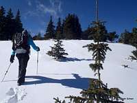
Burning Bear Creek, Burning Bear Trail, Burning Bear Campground. Somehow everything around here is named “Burning Bear” except for the mountain. UN 12069 has been nicknamed “Burning Bear Peak,” perhaps to state the obvious. It is a pleasant, rounded 12er convenient to Denver via the Hwy 285 corridor, near Grant. The peak is readily accessible, surrounded by trails, dirt roads and 4x4 routes, and the summit can be reached via relatively straightforward, navigation over Class 2 terrain.
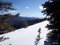
The views from the summit of “Burning Bear Peak” are, in a word, stunning. Due east across the Geneva Creek valley are neighboring Twelvers Kataka Mountain and Mount Logan. To the northeast rise giants Mount Evans and Mount Bierstadt. Squaretop Mountain dominates the northward view, backed-up by Argentine Peak. Rolling westward from this view we see Decatur Mountain and Revenue Mountain. To the northwest are neighbors Landslide Peak, Red Cone and Handcart Peak. Bullion Benchmark and Whale Peak finish up the near-western views. To the south, South Park opens broad and wide and the views finish up to the southeast with Platt River neighbors North Twin Cone and Mount Blaine.
Colorado Rank: 1267th
Prominence: 409 feet
USGS Quad: Montezuma
Planning Map: Trails Illustrated #104: Idaho Springs | Georgetown | Loveland Pass
Rank & Prominence Source: Lists of John
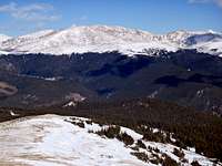 Evans Group from the summit Evans Group from the summit |  West-northwest from summit West-northwest from summit | 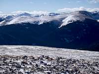 West from the summit West from the summit | 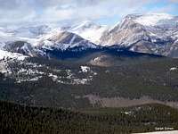 Square Top, Argentine and neighbors Square Top, Argentine and neighbors |
Getting There
 The top of "Burning Bear Peak"
“Burning Bear Peak” is surrounded on all sides by trails and/or roads and is extraordinarily accessible. Here are three key access points:
| Approach | Directions |
|---|---|
| Southeast: Via the Burning Bear Trail, western trailhead | From Hwy 285 about 4 miles southbound from Grant, head north on Park County Road #60 (FS #120) and drive 3 miles to a very small parking area on the right side of the road. This trailhead, reached via graded dirt road, is accessible to all vehicles. |
| Southwest: Via Sawmill Gulch 4x4 Road | From Hwy 285 about 4 miles southbound from Grant, head north on Park County Road #60 (FS #120) and drive for about 5 miles. Notice signs to both Webster Pass and Red Cone. Turn right and on FS 565 (4x4) How far you continue on FS 565 depends on the season, your vehicle and the driver, and how much you want to Jeep vs. boot it. |
| Northeast: Via Burning Bear Trail, eastern trailhead | Take Hwy 285 to Grant. Turn north on Park County Road #62 (Guanella Pass Road) and drive 4.9 miles to the trailhead. At a turn in the road, keep your eyes sharp for a sign and gate on the left (north) side of the road. Park .2 miles further up the road at the Abyss Lake trailhead. This semi-paved road is 2-wheel drive accessible |
Red Tape
 Vanishing Act
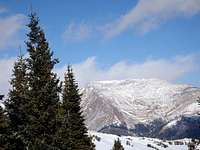 Square Top dominates
| There exists little or no red tape in this part of the National Forest, and this peak can be accessed without fees or permits. Please follow LNT (Leave No Trace) principals:
1. Plan Ahead and Prepare 2. Travel and Camp on Durable Surfaces 3. Dispose of Waste Properly 4. Leave What You Find 5. Minimize Campfire Impacts 6. Respect Wildlife 7. Be Considerate of Other Visitors |
Camping
 Toward Puma Hills
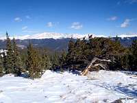 Mount Bierstadt and Mount Evans
| Campground Name | Elevation | Sites | Nightly Rate | Season | Notes |
|---|---|---|---|---|---|
| Hall Valley | 9,900 ft. | 9 | $14 | Late May to early September | Off CR 60 |
| Whiteside | 8,900 ft. | 5 | $12-$13 | Open if road is open (?) | Off CR 62 |
| Burning Bear | 9,600 ft. | 13 | $14 | Late May to early September | Off CR 62 |
Weather & Seasons
 Kicking through the first clearing Kicking through the first clearing | ”Burning Bear Peak” can be an excellent year round mountain, but check conditions in snow season regarding whether or not access roads are passable. Also use snow condition assessment during snow season, particularly on the higher slopes above timberline. The Guanella Pass area is quite popular in snow season and campsites are at a premium in the warmer months. Note that County Road 60 services the popular Red Cone / Webster Pass group of 4x4 trails. |  |