
-
 46371 Hits
-
 90.52% Score
-
 34 Votes
|
|
Mountain/Rock |
|---|---|
|
|
42.26740°N / 112.0963°W |
|
|
Oneida and Franklin |
|
|
Hiking, Skiing |
|
|
Spring, Summer, Fall, Winter |
|
|
9300 ft / 2835 m |
|
|
Overview

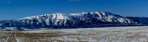
Oxford from Elkhorn
Oxford Peak is the highest summit in the Bannock Range in southeast Idaho. The mountain stands out from all directions. It's hard not to notice by anyone driving along Interstate-15. Oxford Peak has over 4,000 feet of prominence. This makes it one of the most prominent peaks in Idaho. It is also the Oneida County highpoint.
The name of the peak originates from hunters who found oxen tracks at the ford of the nearby creek and therefore named it Oxford. This peak, the ridgeline, the slough and the town of Oxford were also named after the creek. Oxford Peak is located between several valleys including Malad Valley to the west, Marsh Valley to the north and Cache Valley to the east.
The ridge that Oxford Peak is located on is named Oxford Mountain. To make matters more confusing, a peak called Oxford Ridge, labeled on maps, makes up the south end of the ridge. They are separated by a saddle between Peak 8735, known as the Oxford Ridge Highpoint, and Point 8635. The south summit is thought to be a little higher than the north summit. The listed elevations are 9,282 feet for the north summit and 9,300 feet for the south summit. You'll want to hike to both summits since they are so close in elevation. The north summit had a pole attached to a large cemented block of rocks.
There are two main hiking routes to the summit and some lesser traveled routes. The south ridge from Davis Basin starts at a higher elevation than all of the other routes so it is the most preferred if you have a high clearance vehicle. The route from Cherry Creek has the advantage of being accessible to any vehicle when dry. If two vehicles are available, then a full traverse of Oxford Ridge can be done. The register had names mostly from people who live nearby, hunters, and county and prominence peak chasers. There were several ATV riders and motorcyclists in the area but most of them were not planning to go to the summit and stayed below the main ridge. I would say by Idaho standards, this peak is visited often.

Rock Spire
Most of the area surrounding Oxford Peak was settled by the Mormons. The largest city west of Oxford Peak is Malad which is not far from the freeway. Malad Valley was visited between 1818 and 1821 by Donald McKenzie who was a French-Canadian trapper. He named it Malade, a French word meaning sick, because many of the trappers in his group became ill.
Malad was settled in 1864 and two years later it was the fastest-growing place in southeast Idaho. Malad is now known for being home of the Utah lottery. On the north side of the mountain is the town of Oxford and on the east side is the town of Clifton. To the southeast is the city of Preston where gas and other services are available. Preston was settled in 1866, a few years after Franklin, which was the first settlement in Idaho.
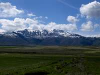
The Bannock Range runs north to south from Pocatello, Idaho and then across the Utah border. Oxford Peak was first ascended by Native Americans, most likely the Bannock Indians, that lived in the area and whom the Bannock Range is named after. The first white men to climb the peak were Henry Gannett and Allen D. Wilson in 1878. Henry Gannett was among the founders of the American Association of Geographers and served as Chief Geographer of the Survey from 1882 to 1914. Gannett Peak in Wyoming was named after him. Allen D. Wilson was a chief topographer and cartographer originally from Illinois. Mount Wilson and Wilson Peak in Colorado were named after him. Between 1873 and 1878, Gannett and Wilson, as part of the Hayden Survey, triangulated across much of western Colorado, western Wyoming, and eastern Idaho.
 Oxford Peak seen from the east in winter - by mtybumpo
Getting There
Davis Basin Trailhead:
Drive on Highway-91 in southeast Idaho. From the city of Preston, turn west onto Oneida Street. Continue for 6.5 miles and the road will curve right onto North Westside Highway. Drive on this road for 5.4 miles to the small town of Clifton which is on State Highway 23. Locate First South Street which is one block south of the Post Office. Drive west on this road for 0.3 mile. Then turn left on Cemetery Road and go 0.7 passing the cemetery along the way. From here turn right onto Clifton Creek Road. This is a dirt road also known as Forest Road 045. Drive up this road passing a few side roads along the way. Always stay on the main road. Drive to the end of this road, which is about 6.4 miles long. The first half of the road is in good condition, but the last half ascends switchbacks and is rough in places. Cars can make it at least two miles on the road. You will need a high clearance vehicle to make it all the way in. There are two unlocked gates that you pass through before dropping down into Davis Basin. Also be aware that cows may be on the road. You can park when you reach the bottom of Davis Basin. You'll know you're there when you see a trail leading north that is closed to vehicles. The trailhead is at about 6,880 feet elevation.
Cherry Creek Trailhead:
From Malad:
Drive on Interstate-15 north of Malad, Idaho. Take (exit 22) toward Devil Creek Reservoir. At the intersection north of the reservoir turn right onto East 8400 North. Continue on this road becoming North Old Highway 191 for 3.5 miles. Then go another 1.7 miles on this road as it starts to parallel 1-15 and is now named South Old Malad Highway. Turn right onto East Guidinger Road which is a dirt road. Follow this road for 2.6 miles and then arrive at an intersection. Turn right and go south on Cherry Creek Road. This is also known as Forest Road 047. Drive on this road for approximately 5.2 miles to the trailhead. This dirt road is in good condition and goes along the side of the Middle Fork of Cherry Creek the entire way. Cars shouldn't have a problem getting to the trailhead if you drive slow. The parking area is at a bend in the road where a jeep trail goes east while the main road continues south. The main road ends a little farther ahead where there is a small campground with sites located in the forest. The trailhead is located at 5,800 feet elevation.
From Downey:
From Pocatello at the intersection of I-86 and I-15, turn south onto I-15 and drive for about 35 miles. Take (exit 36) toward Downey. Drive for another 6 miles along Highway 91 until you arrive at Downey. Alternatively, if coming from the east side of the mountain, drive to Preston on Highway 91 and continue going north for 28 miles. At Downey, drive to the south end of town. Turn west onto South Old Malad Highway. Continue driving for 2.2 miles and then turn south onto Cherry Creek Road. Follow this road for about eight miles to the Cherry Creek trailhead at a dirt parking area near the campground.
Routes Overview
 Saddle below Peak 8735 Saddle below Peak 8735 |
 South Ridge Point 8635 South Ridge Point 8635 |
 South Ridge Point 9098 South Ridge Point 9098 |
Oxford Ridge (South Ridge)
This route starts from Davis Basin and follows the south ridge to the summit of Oxford Peak. This ridge is also known as Oxford Ridge. From the trailhead you will follow a jeep trail. After about a mile, you leave the forest as you reach the base of Oxford Ridge. There is a usually a sign here, stating that Third Creek Trailhead is left and Oxford Ridge and Clifton Overlook are straight ahead. Take the wide trail that goes north up the hillside. The ridge has good views on both sides. Much of the route involves either going over or around all the points on the ridge.
The route goes to Point 8385 which the trail travels right below the top of. Then the trail continues over Peak 8735 which is known as Oxford Ridge Highpoint. From there, the trail descends for about 400 feet to a saddle on the other side. A trail leads northeast down into Pine Corral Spring and Oxford Basin but you'll want to stay on the main ridgeline instead. Hike up from the saddle toward Point 8635. You will meet the trail again to the north of this point. Then the trail passes by Point 8748. You will gain over three hundred feet going over to Point 9098. Then you're in for another descent and lose some of the elevation you just gained.
Once at the saddle on the other side, you'll see Oxford Peak in the distance. The south summit is thought to be a little higher than the north summit. I could not tell much of a difference but the listed elevations are 9,282 feet for the north summit and 9,300 feet for the south summit. Hiking to both summits on the ridge is recommended. The north summit had a pole attached to a rectangular block resembling a chimney and inside of it was a register. On a clear day, you can see much of southeast Idaho including the southern peaks of the Bannock Range and Portneuf Range and also the Bear River Range.
The views of notable mountains in the area include Buck Peak to the south near the beginning of the ridge. Farther to the south are Weston Peak and Old Baldy Peak. To the west is Elkhorn Peak across the valley from Malad Summit. To the north is the Portneuf Range with Sedgwick Peak and its large dome shaped summit ridge. Visible to the northeast are the lower southern peaks of the Portneuf Range such as Thather Hill and Treasureton Hill. To the east is Twin Lakes Reservoir and across Cache Valley is the Bear River Range. This is a long mountain range with several peaks above 9,000 feet elevation.
(12 miles round trip with 3,500 feet elevation gain). The cumulative gain will be more if you ascend every point on the ridge.
 South Summit 9300’ South Summit 9300’ |
 North Summit 9282’ North Summit 9282’ |
 North Ridge North Ridge |
Cherry Creek Route
The route from Cherry Creek is located on the north side of Oxford Peak. From the parking area, hike on the jeep trail that goes east and follows the Left Fork on Cherry Creek. You will pass the confluence of the left fork and middle fork along the way. Keep following the left fork east as it travels along the north side of the creek. At approximately 7,200 feet is a trail intersection. The Aspen Creek route will be coming in from the north where it joins the Cherry Creek route. Now turn right and hike southwest on the trail. You'll gain 400 feet up to Point 7604. On the south side of this point is another trail intersection. The trail to the left goes down into Oxford Basin. Take the trail that goes right up toward the ridgeline. It goes southwest and meets the ridge at about 8,100 feet elevation. In the last mile, you will gain over a thousand feet on the final part of the ridgeline to the summit.
(11 miles round trip with 4,000 feet elevation gain).
Other Routes
There are several other possible routes on Oxford Peak. I have not done the following routes but they are worth mentioning for anyone wanting an alternative. They are listed in no particular order. (1) Aspen Creek is north of Cherry Creek below the north ridge of Oxford Peak. (2) New Canyon is located on the northwest side of the mountain south of Cherry Creek. (3) First Creek is located directly below the west ridge of Oxford Peak. (4) Third Creek trailhead is located east of Upper Deep Creek Reservoir. (5) Gooseberry Creek is located on the northeast side of the mountain near Rockslide Canyon and Oxford Basin.
Views of Oxford Peak
Here are a few photos of Oxford Peak seen from different vantage points around the mountain.
 From the East From the East |
 From the North From the North |
 From the West From the West |
When to Climb
The main hiking season for Oxford Peak is from May through October.
Oxford Peak is dry during summer and you will need to carry all water with you.
During an average year, there will be snowfields on the south ridge into late spring. Mosquitoes and flies will be seen from mid-June through July so bring bug spray. Temperatures can be hot during the summer season but the ridge is usually windy so you can still enjoy a pleasant hiking experience. Don't hike this mountain if the chances of thunderstorms are high. There is nowhere to seek shelter once you are on the open ridgeline. Hunting season takes place in autumn, so use caution and wear orange or bright colors during this time. The best time to see fall colors is from mid-September to mid-October.
Camping
Cherry Creek Campground

Cache Valley
Cherry Creek Campground is located northwest of Oxford Peak. It sits at approximately 5,800 feet elevation. There are about five campsites available on a first-come, first-serve basis. A hiking trail up Oxford Peak also starts near this campground. It is located south of the town of Downey on Forest Road 047.
Twin Lakes Reservoir Campground
Twin Lakes Reservoir is located east of Oxford Peak. It is a popular place to go fishing. They have largemouth bass, perch, rainbow trout and bluegills. There is also water skiing and camping available. Camping at this reservoir costs about $12 to stay overnight. Access is from Twin Lakes Road off Highway 91 north of Preston.
Backcountry Camping Regulations:
Clifton Basin and Davis Basin are the best places to camp for the south ridge route. The only drawback is that you may have to share your campsite with a group of cows that seem to like this area. Camping is free in these areas. Backcountry camping is allowed as long as you follow the rules. You must be 200 feet away from any road, trail or water source. You'll need to practice leave no trace techniques. The backcountry camping limit in one spot is 16 days.
Red Tape

Oxford Peak
None. No fees or permits for hiking this peak.
Oxford Peak is administered by Caribou-Targhee National Forest.
| Pocatello Forest Service Office | Malad Forest Service Office |
| 4350 Cliffs Drive | 195 South 300 East |
| Pocatello, Utah 83204 | Malad, Idaho 83252 |
| Phone: (208) 236-7500 | Phone: (208) 766-5900 |
Books
Idaho: A Climbers Guide: Climbs, Scrambles, and Hikes
By Tom Lopez. This book has four pages on the Bannock Range. It describes Oxford Peak and other mountains in the area.
Trip Reports
(1) 200th P2k for Dean - Written by Dennis Poulin. Dean climbs Oxford Peak, his 200th peak with over 2,000 feet of prominence.
(2) Oxford Peak via Davis Basin - IdahoSummits southeast Idaho county highpoints report. On Day 2 they hiked up Oxford Peak.