
-
 215921 Hits
-
 99.93% Score
-
 169 Votes
|
|
Area/Range |
|---|---|
|
|
46.48397°N / 12.05095°E |
|
|
Hiking, Mountaineering, Trad Climbing, Sport Climbing, Big Wall, Scrambling, Via Ferrata, Skiing |
|
|
Spring, Summer, Fall, Winter |
|
|
10968 ft / 3343 m |
|
|
1 - Overview
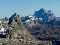
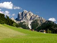
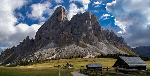 Peitlerkofel / Sas de Pütia, towering above Gömaalm |
Much can be said about the Dolomites, one of the world's most famous and fabulous mountain ranges. Yet, when trying to describe them they also seem to defy words. One quickly runs out of adjectives and comparisons with towers, castles or cathedrals have become the rule. Swiss architect Le Corbusier once called the mountains "Les plus belle archtectures du monde" (the most beautiful architectures on earth) and the phrase he coined made it to just about every guide- or picture-book about the region. Yet, when you stand in the shadow of one of the giant faces or one of the delicate pinacles you cannot but feel the justification of his statement. The work of man seems to pale beside the work of nature.
The Dolomites have been named (indirectly) in honour of Déodat Gratet de Dolomieu, a French geologist and mineralogist, who in 1789 made a voyage through vast parts of Tirol and Grisons. There, at the base of Pflerscher Tribulaun in the Stubai Alps he realized that the rock, from which the mountain was composed of, was different from regular limestone. When treating the minerals with hydrochloric acid they barely reacted (limestone has a strong reaction). The new found mineral later was named Dolomite in Dolomieu's honour and later the whole mountain range received the same name.
 |
 |
 |
However, the assumption that the whole mountain range is made up from this kind of rock is wrong. Dolomite makes up only a small part of the whole region while limestone prevails in many places. Near Marmolada or Latemar you will find limestone as well as volcanic rock. The Padon Ridge consists of lava whith its typical black erosion forms. Some of the subgroups are composed of high quality Dolomite while in others, especially in the northern part of the range rather look and feel like piles of rubbish. Still there are some common denominators: vertical lines dominate everywhere, there are big ledge systems and big high plateaus can be found in many places. At the bases of the mountains there are giant scree slopes.
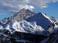
The average hight of the mountains is moderate, around 3000m +/- 200m. Punta Penia on Marmolada, the highest spot of the mountain range, reaches 3343m. Still, as the valleys are profound, huge differences in elevation can be found. Additionally some of the faces show gigantic proportions. The Marmolada south face is about 2km wide and 800m high. The Langkofel / Saslonch / Sassolungo north face is 1km wide and 1500m high. The Civetta north-west face is 1600m wide and 1200m high. Monte Agner in the Pale de San Martino reaches a height of 1800m. And these are only the largest faces ...
 |
 |
 |
The Dolomites constitute one of the largest subranges of the (eastern) Alps. They stretch between the Eisack / Isarco Valley in the west and the Piave Valley in the east and south. The northern boundary is Pustertal / Val Pusteria. The range divides into about 20 different subbgroups of various shapes and sizes. As most of the rock is sedimentary in nature and dates back to the Triassic age, lots of petrified marine life forms can be found. The rather constant general height of the mountains as well as the shape of the subgroups can also be attributed to this origin. Coral reefs and atolls can still be made out today. A very fascinating aspect about the Dolomites is that its subgroups all have very characteristic shapes, which can be easily distinguished when seen from the outside. Moreover, many of the subgroups stand alone between profound valleys and broad mountain passes. Thus, travel in the area is rather easy - a network of roads spans the range.
Generally the heart of the Dolomites is divided into two parts - western and eastern Dolomites. The boundary is the line the line Val Badia-Campolongo Pass-Arabba-Alleghe-Canale d'Agordo (see map below). The groups of the western Dolomites are generally rather large and rather brittle rock often ensures dramatic erosion structures. In the east the groups tend to be small but rock composiition is much more solid so that very compact mountains are formed. In addition to this "Dolomites heartland" there are outlying regions which generally are not counted among the Dolomites though they share most of the geologic and geographic features. East of the Piave River are the Dolomiti Friulane, which often are counted among the Carnic Alps (also here on SP) as well as the Dolomiti Oltrepiave to the south. In the southwest, far beyond the Etsch / Adige Valley there is the Brenta Group, which often is mentioned separately.
 |
 |
 |
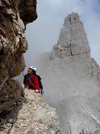
In addition to the geographical division there also is a political one. The area of the Dolomites splits up between the two Italian provinces of Bolzano and Belluno. Roughly speaking, the border between the provinces runs along the former border between Italy and Austria, which existed before WW I. During that war, for 3 years, heavy battles were fought in the range. Many of the positions of that era can still be found in the Dolomites with many a support route still in place. These support routes were converted into vie ferrate, exposed hiking (and climbing) trails, protected by cables and ropes. They have become so popular that meanwhile many more routes have been established. Today, each subgroup has at least one ferrata.
Along this political line there also runs the language border between German Italian. The situation is more difficult, however, since even before WW I this border was by no means exact. Moreover, in the very heart of the Dolomites - based around the Sella- and Fanes Groups, the old rhaetian tongue of Ladinian is spoken. There are many dialects and each valley has its own. Today, the Ladinian language is taught in Schools and Bozen / Bolzano University has its own chair for the language. The Ladinian people is represented in the local autonomous parliament in Bozen / Bolzano.
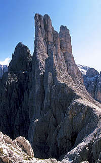
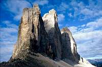
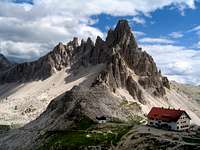
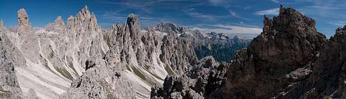 In the Cadini di Misurina
Last but not least: since June 2009 the Dolomites have been elected UNESCO World Heritage Site. The central zone consists of an area of 141.903 ha with an additional buffer zone of 89.267 ha. All aforementioned outlying groups belong to the world heritage.
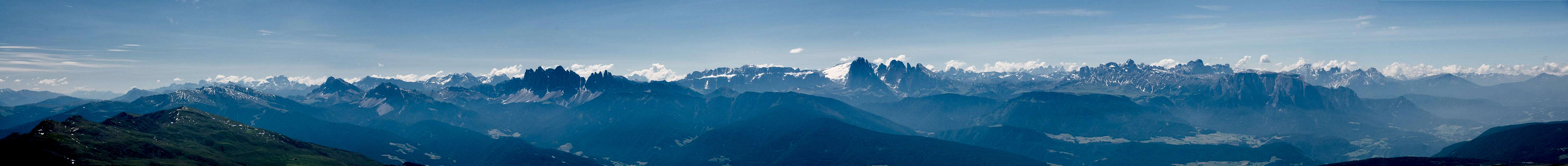
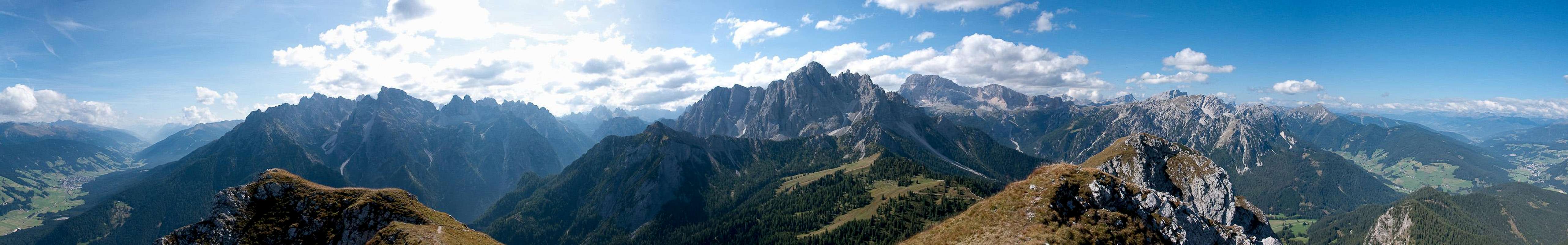
2 - Panoramic view
|
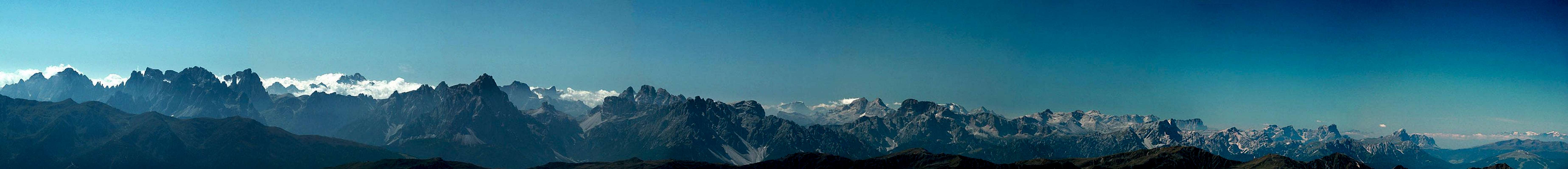
Croda da CampoCima BagniCampanili PopèraCima PopèraMonte GiralbaPala di PopèraCroda Rossa di SestoCima UndiciCroda dei ToniCima UnaAntelaoMonte PaternoCima GrandeLastron dei ScarperiPunta dei Tre ScarperiSorapisPelmoTorre dei ScarperiCroda dei RondoiPiz PopenaMonte CristalloRocca dei BaranciCima Piatta AltaCivettaTofana di MezzoTofana di DentroMonti SpeciePicco di VallandroCroda RossaCime di SestoMarmoladaGran VernelPiccola Croda RossaCunturinesLa VarellaPiz BoèCr. del BeccoC. PisciaduC. NoveC. DieciSassolungoS. CiampacP. PuezDantersassLe OdleC. Colli AltiM. MuroP. Tre DitaSass de PutiaOdle d EoresPlan de CoronesPloseOrtles/Cevedale Group
Croda da CampoCima BagniCampanili PopèraCima PopèraMonte GiralbaNeunerSextener RotwandElferZwölferEinserAntelaoPaternkofelGroße ZinneSchusterplatteDreischusterspitzeSorapisPelmoSchwabenalpenkopfSchwalbenkofelPiz PopenaMonte CristalloHaunoldHochebenkofelCivettaTofana di MezzoTofana di DentroStrudelköpfeDürrensteinHohe GaisslGsellknotenMarmoladaGran VernelKleine GaisslCunturinesLa VarellaPiz BoèSeekofelC. PisciaduNeunerZehnerLangkofelS. CiampacPuezspitzenZwischenkofelGeislergruppeHochalpenkopfMaurerkopfDreifingerspitzePeitlerkofelAferer GeisselnKronplatzPloseOrtler/Cevedale Group
  |
3 - Subgroups
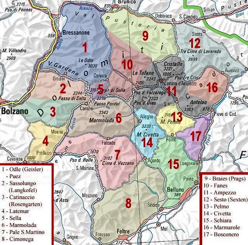 |
The grouping structure of the Dolomites has been the subject of long discussions between the European SP members. If I remember correctly the discussions were mostly led by Italian and German members who preferred to follow the recommendations given by their respective alpine clubs. In the end a compromise was found which is displayed in the map above. Nobody will dispute that there are more than 17 Dolomite Groups, even if you don't count the outlying areas but for the sake of clarity (and compromise) some of the smaller groups were pooled together in one page. In the western Dolomites the Puez - Geisler / Odle Group is one example while the Rosengarten / Catinaccio Group is the other. In the eastern Dolomites the logistical center of Cortina d'Ampezzo pools together all of the smaller Dolomite Groups which surround the town.
In the end, the compromise of the Dolomite grouping structure was the birth of area & range pages though at the time nobody would have called them this way. The following two sections will try to give an overview by the listing of the Dolomite Groups, associated with the 17 SP pages (of which some are still missing). The subsection numbers refer to the numbers on the map above.
4 - Western Dolomites
 |
The western Dolomites are famous for their long and rugged ridgelines. The Geisler / Odle Group, Rosengarten / Catinaccio, Latemar and the north-western chain of the Pale di San Martino all show very impressive skylines. They consist of a multitude of towers, pinnacles and spires and have graced many a picture postcard or calendar cover. The Saslonch / Langkofel / Sassolungo Group with its circular shape still displays its origins as an atoll in the Thethys Sea, while the Sella Group looms like a giant fortress in the heart of the Dolomites. There are three notable karst plateaus in the western Dolomites: the Puez Plateau in the north, the flat topped Sella Plateau in the centre and the Altipiano delle Pale di San Martino in the south. Above all hovers the white glacier of Marmolada, the highest mountain of the Dolomites.
On SP we created 8 groups for the western Dolomites, even though quite often (especially in German literature) more groups have been mentioned. The following list mentions these groups, the very first of which is only added as it is located within the established boundaries though the geology of its mountains and meadows differs a lot from the remainder of its group. The Marmolada- and Pale di San Martino Groups both have a very complex structure and might be divided in further subgroups. However, on SP we decided to keep them in the bigger boundaries as most literature seems to agree.
- Puez - Geisler / Odle Group1.1 Gadertal / Alta Badia Dolomites
1.2 Aferer Geiseln / Odle di Eores and Peitlerkofel / Sas da Pütia
1.3 Geisler / Odle Group
1.4 Puez Group - Saslonch / Langkofel / Sassolungo Group
- Rosengarten / Catinaccio - Schlern / Sciliar3.1 Schlern / Sciliar and Seiser Alm / Alpe di Suisi
3.2 Rosengarten / Catinaccio
3.3 Larsec - Latemar
- Sella Group
- Marmolada Group
- Pale di San Martino
- Cimonega Group
5 - Eastern Dolomites
 |
The eastern Dolomites are often reduced to the mountain groups around Cortina d'Ampezzo, though there's more to this half of the range. But here in the Cortina Dolomites you can find another important aspect of the whole mountain range: small standalone groups which are separated from each other by profound valleys and mountain passes. Monte Pelmo is the archetype of these mountains, a huge, monolithic block of stone, which stands out among its neighbours like a giant cube. Cristallo and Sorapiss, Marmarole and the Tofane complete the picture.
However, with the Sexten / Sesto Dolomites in the east there is another complex mountain group, one of the most beautiful ones of the whole range. There you will find Drei Zinnen / Tre Cime, the best known landmark of the Dolomites. Far to the south the giant line of Civetta attracts climbers with its huge north-west face as well as the southern end points of Torre Venezia and Torre Trieste. The Fanes Group as well as the Prags / Braies Dolomites are rather known for their plateaus - Fanes, Fosses and Senes. Here some of the most important slab climbs can be found (Zehner / Sass de les Diisc / Cima Dieci, Seekofel / Sas dla Porta / Croda del Becco).
- Prags / Braies Dolomites
- Fanes Group
- Cortina Dolomites11.1 Antelao
11.2 Sorapiss
11.3 Cadini di Misurina
11.4 Pomagagnon - Cristallo - Popena
11.5 Col Becchei
11.6 Tofane
11.7 Averau - Nuvolau
11.8 Croda da Lago - Formin – Cernera - Sexten / Sesto Dolomites
- Monte Pelmo
- Civetta
- Schiara
- Marmarole Group
- Bosconero Group
6 - Alte Vie delle Dolomiti
In the mid 1960s the first trekking route of the Dolomites was established, aroute which today is called Via Classica or Alta Via delle Dolomiti No 1. It runs between Pragser Wildsee / Lago di Braies and the city of Belluno. The 150km route is divided into 13 stages, which all end either at one of the many mountain huts or in one of the villages of the valleys. Over the years nine more Alte Vie came into life, the first six within the 1960s and 1970s, the four last in the 1970s and 1980s. While most of the trekking trails are comparatively easy with one or two Vie Ferrate as stages, some, like Alta Via No 7 are very demanding.
There are many web sites dealing with the Alte Vie, even wikipedia has short descriptions for each one. Just Google for the Italian (Alte Vie delle Dolomiti) or German (Dolomitenhöhenweg) names. The best ressource is:
www.dolomiti-altevie.it
Moreover, there are books describing the trekking trails. You will find them in the listings of the last section. The following table gives a very short abstract of the trekking trails.
| Trail No. | Name | Starting Point | End Point | Length | Duration |
| Alta Via n. 1 | Via Classico | Pragser Wildsee / Lago di Braies | Belluno | 150km | 13 days |
| Alta Via n. 2 | Via delle Legende | Brixen / Bressanone | Feltre | 185km | 15 days |
| Alta Via n. 3 | Via dei Camosci | Toblach / Dobbiaco | Longarone | 120km | 10 days |
| Alta Via n. 4 | Via Grohmann | Innichen / San Candido | Pieve di Cadore | 90km | 8 days |
| Alta Via n. 5 | Via di Tiziano | Sexten / Sesto | Pieve di Cadore | 100km | 10 days |
| Alta Via n. 6 | Via dei Silenzi | Sappada | Vittorio Veneto | 190km | 14 days |
| Alta Via n. 7 | Via di Lothar Pateras | Pieve d’Alpago | Segusino | 110km | 11 days |
| Alta Via n. 8 | Via Panoramica | Brixen / Bressanone | Salurn / Salorno | 160km | 13 days |
| Alta Via n. 9 | Via Transversale | Bozen / Bolzano | Santo Stefano di Cadore | 180km | 14 days |
| Alta Via n. 10 | Judikarienhöhenweg | Bozen / Bolzano | Lago di Garda | 200km | 18 days |
7 - Getting There
The Dolomites are located in the north-east of Italy in the regions of Trentino - Alto Adige and Veneto. They can be reached most easily by car since a whole web or roads cuts through the range.
Train service only reaches the outlying valleys:
- Etsch / Adige and Eisack / Isarco Vallleys in the west and Piave Valley in the east and south: Trenitalia
- ustertal / Val Pusteria in the north: Pustertalbahn
There is a very good bus service for the whole area: Dolomitibus. As you can see from the timetables, most of the towns and villages are only touched upon a few times per day. You have to plan your trips accordingly.
The closest airports are:
- Ronchi dei Legionari
- Venezia Marco Polo
- Bergamo Orio al Serio
- Verona Villafranca
- Innsbruck Kranebitten
- Munich Franz-Josef Strauß
8 - Weather Conditions
9 - Accommodation
Naturally, all accommodation can be found in the valleys between the Dolomites mountain Groups. There is a great number of Web pages and google will be a good ressource to find hotels or apartments. The following two URLs link to overview pages, where you can find info for a greater part of the region.
- dolomitsinfo.com - Overview over the complete region, including the Brenta Group
- suedtirolerland.it - Overview South Tirol, including the northern and western parts of the Dolomites
10 - Maps & Books
10.1 - Maps
10.1.1 - Digital Maps
- http://www.pcn.minambiente.it/GN/index.php?lan=en - Different types of maps, going all the way down to topo maps 1:25000
- www.maptk.dnsalias.com/ - Free MapSource topo Map for Garmin devices
10.1.2 - Regular Maps
- Tabacco Maps
Tabacco Maps are arguably the best topographic maps in the Dolomites. They are scaled 1:25000 and cover the whole north-eastern part of Italy. The following table shows the maps available for the region of the Dolomites.
Map No Map Name ISBN 003 CORTINA D`AMPEZZO E DOLOMITI AMPEZZANE 978-8883150036 005 VAL GARDENA-ALPE DI SIUSI / GRÖDEN-SEISERALM 978-8883150050 006 VAL DI FASSA E DOLOMITI FASSANE 978-8883150067 007 ALTA BADIA-ARABBA-MARMOLADA 978-8883150074 010 DOLOMITI DO SESTO / SEXTENER DOLOMITEN 978-8883150104 014 VAL DI FIEMME_LAGORAI-LATEMAR 978-8883150142 015 MARMOLADA-PELMO-CIVETTA-MOIAZZA 978-8883150159 016 DOLOMITI DEL CENTRO CADORE 978-8883150166 017 DOLOMITI DI AURONZO E DEL COMELICO 978-8883150173 022 PALE DE SAN MARTINO 978-8883150227 023 ALPI FELTRINE - LA VÈTTE - CIMÒNEGA 978-8883150234 024 PREALPI E DOLOMITI BELLUNESI 978-8883150241 025 DOLOMITI DI ZOLDO CADORINE E AGORDINE 978-8883150258 029 SCILIAR / SCHLERN / CATINACCIO / ROSENGARTEN / LATEMAR - REGELBERG 978-8883150296 030 BRESSANONE / BRIXEN - VAL DI FUNES / VILLNÖSS 978-8883150302 031 DOLOMITI DI BRAIES / PRAGSER DOLOMITEN / MAREBBE / ENNEBERG 978-8883150319 - Kompass Maps
Kompass has Maps in two scales, 1:25000 and 1:50000. The former are of similar quality as the Tabacco Maps, but are folded in smaller format. The latter maps are excellent overview maps and suffice for most hikes. In the rocky terrain beneath the big Dolomite faces they can become ambiguous. For a full catalogue see www.kompass.at.
10.2 - Books
There is an endless number of guidebooks about the Dolomites. The following list cannot be complete but is supposed to list the best and / or most complete sets of books. Most literature can be found in Italian and German, which is why these languages top the list. The English books all rather are overview guides.
10.2.1 - German
- 10.2.1.1 - Hiking
Rother Verlag has six hiking guidebooks for the Dolomites. Though they sometimes overlap imho they are the best hiking ressource in German language. (Kompass has four guidebooks of similar quality. Unfortunately both editions miss the southern Dolomites (Bosconero, Cimonega, Pale di San Martino))
- Dolomiten 1
Grödner Tal – Villnößtal – Seiser Alm
ISBN: 978-3-7633-4248-8 - Dolomiten 2
Eggentaler Berge – Latemar – Rosengarten
ISBN: 978-3-7633-4059-0 - Dolomiten 3
Gadertal – Von Bruneck bis Corvara
ISBN: 978-3-7633-4060-6 - Dolomiten 4
Fassatal mit Marmolada und Rosengarten
ISBN: 978-3-7633-4061-3 - Dolomiten 5
Sexten – Toblach – Prags
ISBN: 978-3-7633-4199-3 - Dolomiten 6
Rund um Cortina d’Ampezzo
ISBN: 978-3-7633-4063-7
- Dolomiten 1
- 10.2.1.2 - Alta Via
Dolomiten-Höhenwege 1-3
Rother Verlag
ISBN: 978-3-7633-3103-1
Dolomiten-Höhenwege 4-7
Rother Verlag
ISBN: 978-3-7633-3369-1
Dolomiten-Höhenwege 8-10
Rother Verlag
ISBN: 978-3-7633-3368-4 - 10.2.1.3 - Via Ferrata
- Klettersteige Dolomiten
Rother Verlag
ISBN: 978-3-7633-3096-6 - Dolomiten Süd, Klettersteige
Kompass Verlag
ISBN: 978-3-85491-808-0 - Dolomiten-Nord, Klettersteige
Kompass Verlag
ISBN: 978-3-85491-806-6 - Hülslers Klettersteigführer
Bruckmann Verlag
ISBN: 3 7654 4161 9
- Klettersteige Dolomiten
- 10.2.1.4 - Climbing
There is a queer mix of guidebooks out there. The best ones are the ones of the German Alpine Club, of which only two guides remain available. There are three guidebooks by Mauro Bernadi, which reportedly are excellent and which cover some additional areas. The last book of the list is the only guidebook which covers the whole range and which - in its English translation - has become rather popular. However, climbers agree that it is lacking in detail and that some of the routes are much better than the guidebook makes them. So take care!
- Dolomiten – Sella und Langkofel
Alpenvereinsführer
Rother Verlag
ISBN: 978-3-7633-1315-0 - Sextener Dolomiten
Alpenvereinsführer
Rother Verlag
ISBN: 978-3-7633-1255-9 - Klettern in Cortina D'Ampezzo
Mauro Bernardi
Athesia Verlag
ISBN: 978-8887272949 - Klettern in Gröden und Umgebung
Mauro Bernardi
Athesia Verlag
ISBN: 978-8882666095 - Klettern im Rosengarten und Umgebung
Mauro Bernardi
Athesia Verlag
ISBN: 978-8882665692 - Dolomiten. Kletterführer
Anette Köhler, Norbert Memmel
RotherVerlag
ISBN: 978-3763330157
10.2.2 - Italian
- 10.2.2.1 - Hiking
The following are the translations of the guidebooks mentioned in the German section. They focus on the northern part of the Dolomites.
- Dolomiti 1
Val Gardena
ISBN: 978-3-7633-4288-4 - Dolomiti 2
Monti della Val d’Ega – Latemar – Catinaccio
ISBN: 978-3-7633-4159-7 - Dolomiti 3
Val Badia – Da Brunico a Corvara
ISBN: 978-3-7633-4160-3 - Dolomiti 4
Val di Fassa con Marmolada e Catinaccio
ISBN: 978-3-7633-4161-0 - Dolomiti 5
Sesto – Dobbiaco – Braies
ISBN: 978-3-7633-4162-7 - Dolomiti 6
Attorno a Cortina d'Ampezzo
ISBN: 978-3-7633-4163-4
- Dolomiti 1
- 10.2.2.2 - Alta Via
- 10.2.2.3 - Via Ferrata
- 10.2.2.4 - Climbing
10.2.3 - English
- 10.2.3.1 - Hiking
- Shorter Walks in the Dolomites: 40 Selected Walks
Cicerone Press
ISBN: 978-1852843519 - Walking in the Dolomites: 28 Multi-Day Routes
Cicerone Press
ISBN: 978-1852843854
- Shorter Walks in the Dolomites: 40 Selected Walks
- 10.2.3.2 - Alta Via
- Dolomites Trekking - AV1 & AV2
Trailblazer Publications
ISBN: 978-1873756836
- Dolomites Trekking - AV1 & AV2
- 10.2.3.3 - Via Ferrata
- Via Ferratas of the Italian Dolomites: Vol 1: North, Central and East
Cicerone Press
ISBN: 978-1852845926 - Via Ferratas of the Italian Dolomites: Southern Dolomites, Brenta and Lake Garda Area
Cicerone Press
ISBN: 978-1852843809
- Via Ferratas of the Italian Dolomites: Vol 1: North, Central and East
-
- Dolomites West & East (Selected Climbs)
R. James
Cordee Publications
ISBN: 978-0900523656 - Classic Rock Climbs in the Dolomites
A. Köhler, N. Memmel
Baton Wicks Publications
ISBN: 978-189857334010.2.3.4 - Climbing
- Dolomites West & East (Selected Climbs)
- Dolomiten – Sella und Langkofel
Portraits of Dolomites Mountains
The idea of this chapter is to present the wonderful Dolomites mountains on a map - by hundreds of pictures which can be found on the web. You can see how each mountain looks like by up to 8 pictures, showing it from the sides of 8 principal directions of windrose. Finding new representative pictures, this collection will grow.