
-
 156198 Hits
-
 98.57% Score
-
 85 Votes
|
|
Mountain/Rock |
|---|---|
|
|
45.93738°N / 7.86667°E |
|
|
Mountaineering, Ice Climbing, Skiing |
|
|
Spring, Summer |
|
|
15203 ft / 4634 m |
|
|
Overview
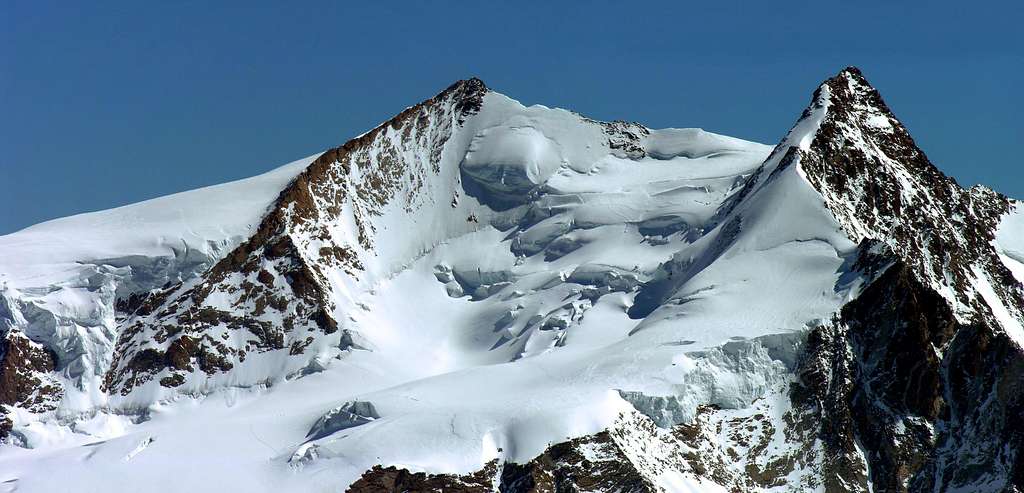
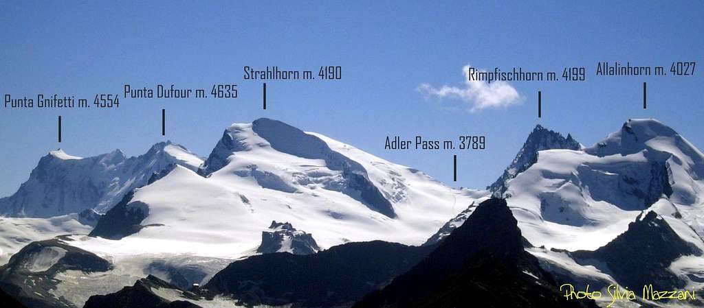
Dufourspitze/Punta Dufour 4634 m
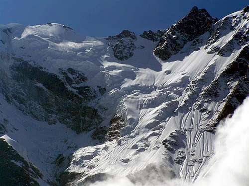
Dufourspitze/Punta Dufour belongs to the Monte Rosa massif and is the third highest mountain of the Alps, after Mont Blanc 4810 m and Monte Bianco di Courmayeur 4748 m. It is the culminating summit of the Monte Rosa group and rises between Colle Zumstein, which divides it from Punta Zumstein, and the Sella d'Argento or Silbersattel which divides it from Punta Nordend. It's also the highest mountain of Switzerland and entirely situated in the Swiss municipality of Zermatt, nearby the Italy-Switzerland border. In fact the mountain is not situated on the border ridge, rather on a ridge extending westward into the Swiss territory.
Its name was given by the Swiss Federal Council in the year 1863 in honor of Guillaume-Henri Dufour, army general and topographer, inventor of the Dufour map and co-founder of the Red Cross. This mountain was first climbed in 1855 by a team of English alpinists, among which Charles Hudson, and Swiss guides and porters, later than most of the other Monte Rosa summits. Check here the complete list of the 82 alpine Fourthousanders and the 46 minor summits: Club4000.
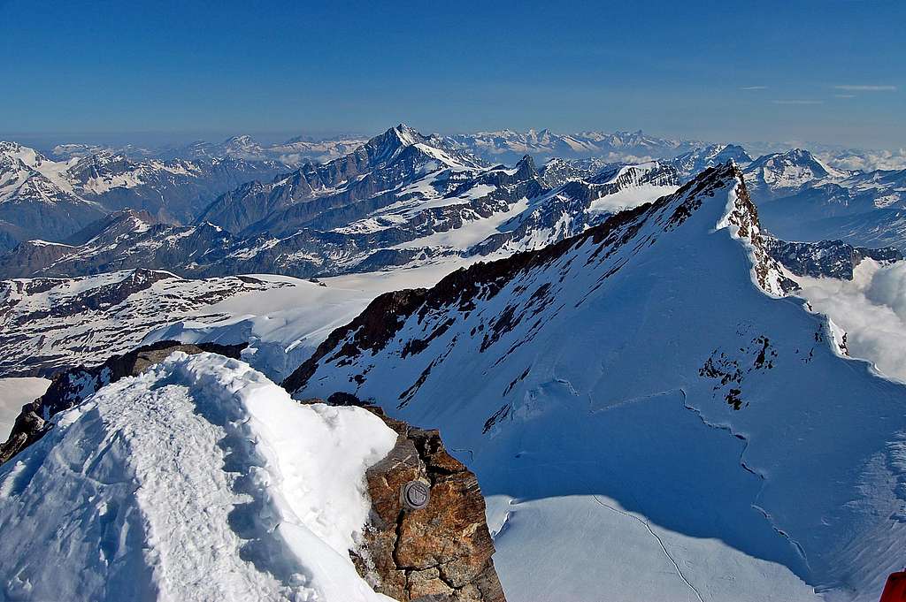
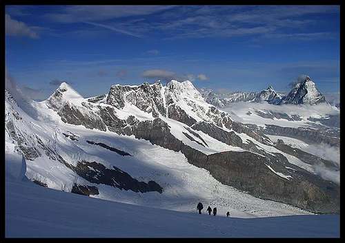
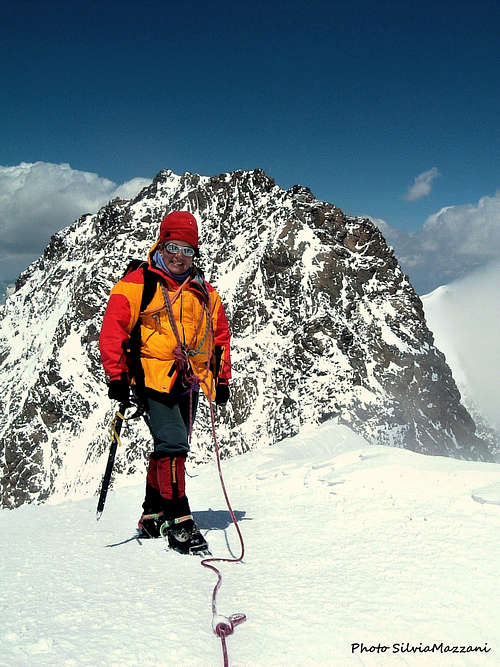
The most attended route is the one on the West ridge across the Sattel, the Swiss Normal route, which is frequently traveled even in the spring on skis. It's a long and beautiful ascent that rises along the basal moraines, then follows the Monte Rosagletscher and reached the Sattel climb up the West Ridge to the top. The view from the summit gives a peculiar feeling looking down on the near Matterhorn, however the view down to the Italian Macugnaga is not as overwhelming as from Nordend, since Dufourspitze is not located on the Monte Rosa ridge, which forms the frontier between Italy and Switzerland, but one hour away to the west. This is the route of the first summiters and starts from the Monte Rosa hut on the Swiss side. Dufourspitze is not considered as a difficult mountain if climbed following this popular and frequented route, but it's necessary to be fully equipped with axe, rope, crampons and warm and wind resistant clothes. Only Mont Blanc is higher in the Alps, and it is highly recommended not to start the climb under dubious weather conditions.
All the routes starting on the Italian side are rather difficult to climb.
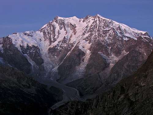
The Macugnaga wall is the highest one in Europe and drops down a full 2600 meters! Its bright white wall reflecting the morning sun can be seen from hundreds of miles away. It is a pity that this wonderful wall is extremely dangerous or enormously long to climb.
Getting there
Swiss side - The starting point to climb Dufourspitze from the Swiss side is the Monte Rosa Hütte 2883 m. The easiest way to reach this refuge is to take the train from Zermatt to Rotemboden. It is also possible to go on foot following the road and then the path, following the signs for the Gornergrat.
By train from Zermatt to Rotemboden. Here take the path that cuts and descends diagonally and gently towards the moraine. If there is still snow the slopes are very steep.
You touch the Gornergletscer, sections equipped with ropes, poles, white-blue flags. Some sections equipped with wooden pegs and cables under the shelter due to the considerable lowering of the glacier
Italian side - The starting points to climb Dufourspitze from the Italian side are the refuges Mantova and Gnifetti. Two different approachs ways are possible depending if coming from the Valle di Gressoney (Aosta) or from Val Sesia (Piemonte).
Access via the Valle di Gressoney (Aosta Valley) - From the A5 Torino – Aosta Highway, exit Pont St. Martin and take the Valle di Gressoney, getting to Gressoney St. Jean, Gressoney La Trinité and Staffal. From Staffal take the Cable car to Alpe Gabiet – Passo dei Salati - Indren
Access via the Val Sesia (Piemonte) - From the A26 Highway exit to Romagnano Sesia and take the road to Varallo Sesia. Here continue following all the Val Sesia road to Alagna Valsesia. From Alagna Valsesia take the Cable car to Pianalunga - Passo dei Salati – Indren
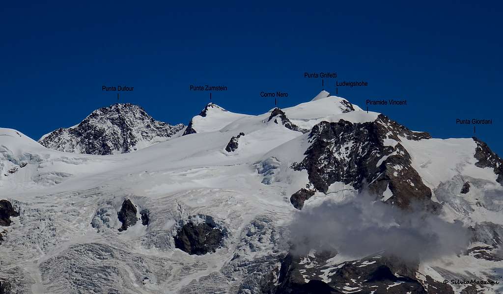
Approach to Refuge Mantova 3470 m and Capanna Gnifetti 3611 m
The Rifugio Mantova is located at the foot of the Garstelet Glacier, just below the Capanna Gnifetti. Both huts are the starting point for the ascent to Piramide Vincent and to some other peaks of the Monte Rosa Group, such as Punta Gnifetti, Corno Nero, Eastern Lyskamm. You pass the cable car station leaving it to the right and head towards the small Indren glacier to cross it completely. In this section it is not normally necessary to use the crampons as there are no strong slopes and the track is normally obvious. In addition, snowfall is reduced year by year. In any case, it is appropriate to evaluate according to the season and the conditions. Crossing the glacier, or what remains of it, you reach the base of a rocky wall, here you can alternatively follow two trails: the high one that with small bends leads to the small rocky wall, where the path is equipped with fixed ropes and ladders, or follow a low trail that goes beyond the glacier and runs on the more gentle side of the wall reaching the Rifugio Mantova trail. Using the high track, it shortens the route for about 15 minutes. From here you can see both Rifugio Mantova and Rifugio Gnifetti. With a slight descent to the left you reach the Rifugio Mantova, while crossing the area of stones and rocks you enter the glacier of the Garstelet and following the obvious track to the Rifugio Gnifetti.
The Normal routes
1. Swiss Normal route from Monte Rosa Hut 2795 m
Difficulty: PD+ (Alpine scale)
Difference in level: 1850 m
Long and beautiful ascent at high altitude, in a superb environment, requires the complete glacier equipment.
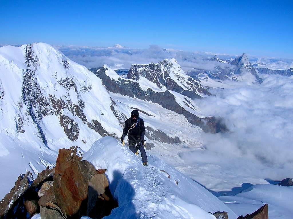
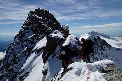
The Normal route to the summit takes place along the Swiss side starting from Monte Rosa Hütte. It develops almost entirely on the glacier and is considered an easy climb. Despite its length it is one of the most popular routes in the Valais. From the refuge, go up the moraine of the Grenzgletscher passing from the Unter Plattje and then from the Obere Plattje 3277 m. It is wise to check it the day before at daylight, so you do not lose time in dark of the morning. Enter the very crevassed Monte Rosa Gletscher and follow it leaving the 3827 altitude on the left. At a certain point it bends to the right leaving the track that goes up to the Silbersattel and to the Punta Nordend to gain the Sattel saddle 4359 m, from which one finally runs along the west ridge that leads to the summit.
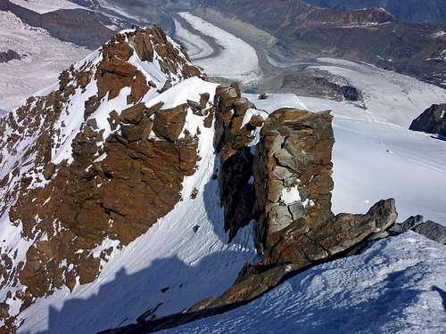
At 4000m leave the Silbersattel trail, turn right towards the ridge that comes down from Dufourspitze. At 4500 m you reach the saddle, where the skiers leave their equipment. After a climb of an icy slope, you reach the rocky west ridge that leads to the top. A steep rock is climbed in a couloir of the north side. The flatter part reminds of a cemetery because many people feel they must have a memorial tablet on the highest Swiss mountain, although they did not die there. A cleaning squad would be appreciated. Difficulty III on dry rock. 7 hours from the hut.
2. Italian Normal route
Difficulty: AD+ (Alpine scale)
Difference in level: 1000 m
This is the easiest ascent route on the Italian side. Varied and interesting route in a grandiose environment, rather demanding with sections of climbing, various ups and downs and stretches on delicate and airy ridges.
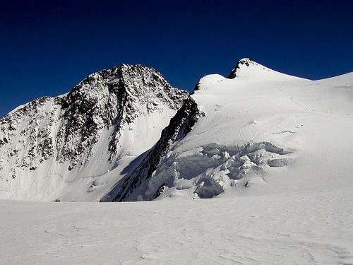
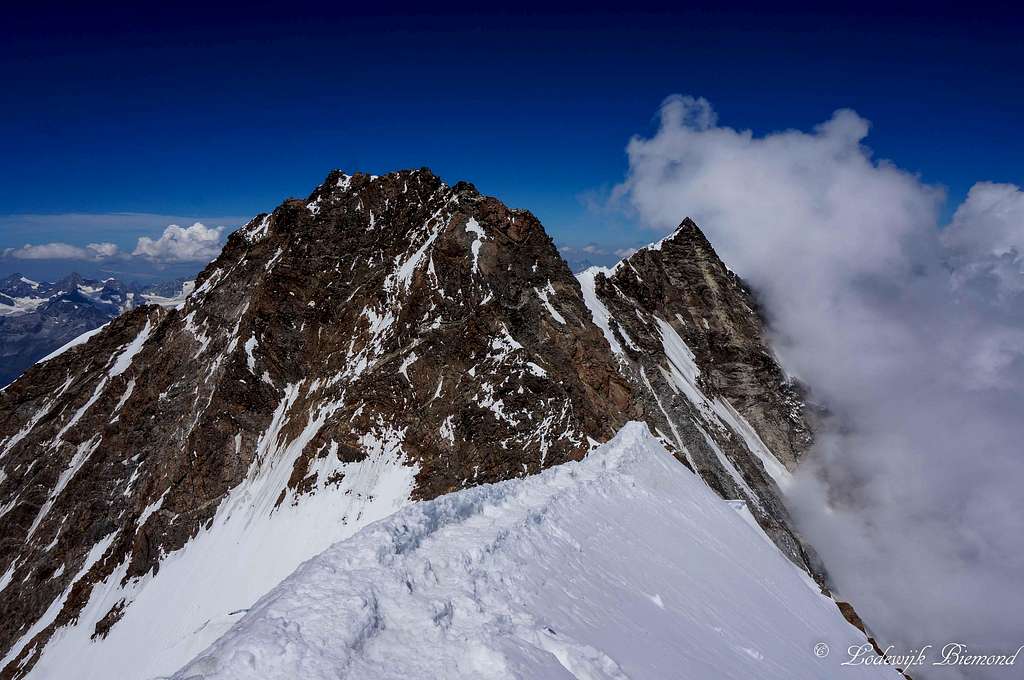
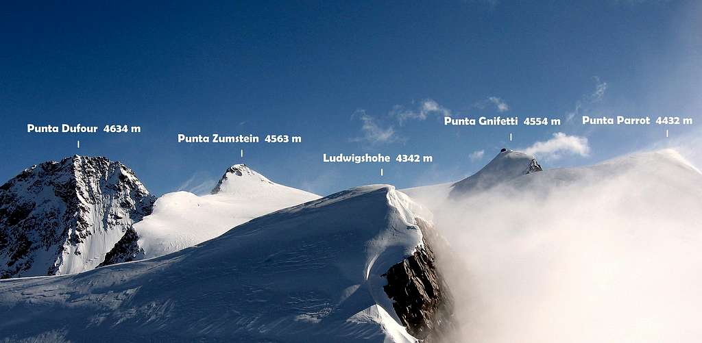
The standard Italian ascent to the summit is rather long and delicate and consists to reach the Colle Gnifetti 4454 m, a wide snow saddle between Punta Gnifetti and Punta Zumstein. To climb this route you need to follow the Punta Gnifetti Normal route. This route starts from either Rifugio Gnifetti m. 3611 or Mantova m. 3470. From this shelters gain the starting point of the Lys Glacier, which begins nearby Capanna Gnifetti. Enter the glacier and follow it at first diagonally to the left (toward North-East) along a steep ramp, then toward North rising on moderate ice-slopes, never too away from the Piramide Vincent. In some sections the route presents a few passages between wide crevasses. Continue always along the track, usually present in summer, heading to the Colle del Lys. After passing a series of irregular slopes, the itinerary gets the snowy basin below the Balmenhorn at about 4000 m., then the Colle del Lys just near Eastern Lyskamm to the left. Descending briefly, the route takes a long and mainly flat trajectory just below a few small seracs at the base of Punta Parrot, then leads to the Colle Gnifetti 4552. From the col, leaving the obvious trail leading to Punta Gnifetti to the right, go to the eastern edge of the plateau and turn left to climb the SW ridge of Punta Zumstein. It initially rises on a snowy and not very steep terrain, then the inclination increases and the ridge becomes rather narrow, until reaching the short and rocky final stretch and the summit of Punta Zumstein 4563 m). Descend along the airy North ridge, often icy, rather steep and delicate, then easier and with some rocks. Reached the Colle Zumstein 4452 m start to climb the SE ridge of the Dufour. Initially there are some easy rocky outcrops (a more high gendarme is to be avoided on the left), then the ridge becomes steep and climb vertical steps and slabs (II and III) until it reaches the Grenzgipfel 4618 m. Reached a saddle, a subsequent steep rock (III) leads to the Ostspitze 4632 m, from where it continues along the rocky summit ridge, almost flat but aerial. Once around a last gendarme, on the left along a chimney you reach the summit.
Starting from Rifugio Mantova or from Capanna Gnifetti, the ascent is long and demanding and must be faced with good mountain conditions and stable weather. If, on the other hand, you prefer to stay overnight at Capanna Margherita, thus saving a considerable difference on the second day, the itinerary is the same up to Colle Gnifetti, then to the right to the Capanna Margherita from which you will have to go back down to the Colle Gnifetti the next morning.
Descent: you can follow the ascent route, or go down the west ridge towards Monte Rosa hutte
Other routes
Cresta Rey
Summit altitude: 4634 m
Difficulty: D-
Exposition: South
Difference in level: 1500 m
The approach to Cresta Rey starts from the Capanna Gnifetti on the Italian side. From this refuge follow the first part of Punta Gnifetti Normal route up the Lys Glacier to the Colle del Lys 4248 m, continue for a few tens of meters on the Punta Gnifetti standard route and turn left across the Grenzgletscher basin bypassing the base of the SO ridge of Punta Zumstein around 4025 m (pay attention to the SO ridge which can discharge and to the large crevasses, which must be passed towards the right. Head toward the Cresta Rey going up again, to then heading to the right to overcome the crevasses, At about 4200 m of altitude you cut the slopes below Punta Zumstein to reach the start of the climb at an altitude of about 4230. Climb the ridge with non-obligatory passages (and some stretches of debris) of II-III. Over half way there is a move of IV, that can be avoided on the left. From the attack to the summit about 2-4h depending on the conditions of the terrain.
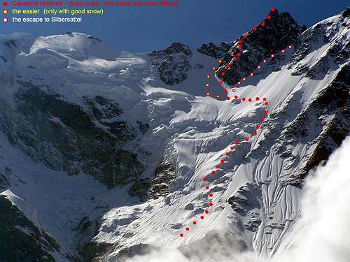
East wall and East Ridge from Marinelli bivouac 3036 m
Summit altitude: 4634 m
Difficulty: D+, II, III, IV on rock,45° to 55° on ice
Exposition: East
Difference in level: 1600 m
The east face of Monte Rosa is the most mighty wall of the Alps. The ascent of this route is demanding due to the long development and the considerable difference in height. It should be tackled only in conditions of good weather, low temperatures and stable snow. However, the objective dangers remains considerable.
Rather difficult and dangerous trip on ice and rocks, since the Marinelli couloir must be crossed, which is the waste basket of both Dufourspitze and Nordend. So be sure to climb only on a very cold day and start at midnight, since the morning sun starts heating up early on the east face. After leaving the Bivacco Marinelli stay on the Marinelli spur and cross the sometimes very icy and dangerous couloir in full speed and continue on the rocky Imseng spur. Then head directly to the foot of the east ridge or left of it, which offers difficult but not dangerous climbing on solid rock. Climb the Grenzgipfel and follow the route from the Margherita hut. Ca. 12 hours depending on conditions.
If you are late or have problems with the altitude you can switch to the Zumsteinspitze, which is easier and faster. Be sure to stay below the horizontal schrund. By the way, this is the ski descent for very hazardous skiers. In general it is not wise to climb down this face. The ascent via Silbersattel is steeper and longer, not recommended.
In order to study the Italian side, do not go to the Moro Pass as is sometimes recommended, but rather climb the Pizzo Bianco (3215 m), it gives better insight.
Red Tape
No fees no permits required. Be aware that the town of Zermatt has a peculiarity: it cannot be reached by car, nor can it be circulated inside by car.
To reach Zermatti you can drive to Tasch and then take the train or the shuttle.
Accomodation
Swiss Side
Starting point: Rotemboden
Starting altitude: 850 m | Difference in height: 940 m | Journey time: 3/4 hours
Opening Period: from mid-June to mid-September
Beds: 120 places (For hygiene reasons, a sleeping bag is mandatory)
Management: Swiss Alpine Club (Manuela and Horst Brantschen)
Tel. +41 027 967 21 15 | +41 027 956 31 50
Italian Side
1. Macugnaga (1327 m) is a small town in the valley Anzasca with less than 1000 inhabitants at the foot of the East Face of Monte Rosa. It can be reached by car and bus from Piedimulera on the Simplon line (Berne - Milan). Drivers from north along the Gotthard autobahn should head for Locarno (circumvented by a road tunnel) and continue along the Lago Maggiore to Intra and enter the Simplon route near Ornavasso.
A slightly slower variation leads from Locarno through the valleys Centovalli - Vigezzo to Domodossola. Funny thing I observed: the river flowing west on the Italian side (Vigezzo) is called Melezzo (masculine noun), on the Swiss side flowing east (Centovalli) is called Melezza (feminine) by the local people. The geographists, however, are afraid of additional Melezzini and call them Mellezzo occidentale and orientale.
Camping is possible. Best hotel is probably Alpi (1200 m) at the lower end of Macugnaga, at the upper end of the road is Albergo Cristallo (1360 m).
There are two cable cars starting in Magugnaga. One leads up to the Moro pass (2868 m); the other - a chair lift - leads from the Cristallo hotel to Burki - Belvedere (1932 m). Some maps show additional cable cars, that do not exist: to Piani Alti above Rosareccio (destroyed) and to Zamboni hut from Belvedere.
2. Bivacco Marinelli (3036 m), 12 places, not guarded, open all year round, CAI Milano.
Acces via chair lift to Belvedere (1932 m), use the trail to Zamboni hut that leads first over the Belvedere glacier, then on its eastern moraine. A yellow sign shows a narrow path leading down the moraine to the ice. Then climb steeply (sometimes crampons) the back of the glacier which is completely covered with rocks and sand and head to the the Crestone (spur) Marinelli. Keep right (north) of the spur until you find a broad band of grass and stones that leads easily to a saddle on the spur. Follow the tracks on the spur; at 3000 m it turns left halfway to the Canalone (couloir) Marinelli where the wooden stone hut is located. 3-4 hours.
Since the traversing of the glacier near the Zamboni hut is not pleasant (and often officially forbidden), crossing the glacier at the Belvedere to the Alpe Fillar may be preferable. I can also recommend a longer path. Follow the ugly road that starts near the chair lift station. Short before Burki stay on the left (northern) side of the Anza river and follow the sign for the Sella hut. Before reaching the granite wall, you see a big waterfall to your right and a path zigzagging south of it. Leave the road and head to the waterfall where you will find this path. No sign! After a flat grassy shoulder follow the yellow sign that shows left to the Sella hut. Enter and cross a gorge. At Roffelstafel 1905 m, leave the Sella path and keep straight to Alple Fillar and the foot of the Marinelli spur and join the normal path. Longer, nicer, cheaper, more beautiful! 4 - 5 hours.
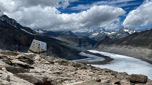
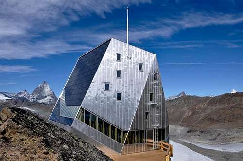
3. Capanna Margherita 4554 m
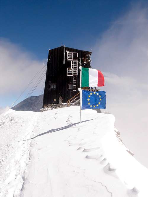
The Capanna Margherita is the highest hut of Europe. The access to the refuge - located on the summit of Signalkuppe-Punta Gnifetti 4554 m - is via the Normal ascent route to Punta Gnifetti. See here on SP the description of the route: Punta Gnifetti Normal route.
When To Climb
Mountaineering: June to September
Ski: March to May
Meteo
MeteoSwitzerland
Meteo Valle d'Aosta
Guidebooks and maps
Guidebooks


 Guidebook")

"Il grande libro dei 4000" by Marco Romelli, Valentino Cividini - Idea Montagna Editore, 2015
-“Monte Rosa” by Gino Buscaini (Club Alpino Accademico Italiano) – Collana Guide dei Monti d'Italia CAI-TCI (Club Alpino Italiano-Touring Club Italiano)
-“Tutti i 4000” – L’aria sottile dell’alta quota” – CLUB 4000 CAI TORINO – Vivalda Editori
-“The 4000 of the Alps” by Richard Goedeke (CAAI) – All the normal routes to the 4000m. summits of the Alps – Libris Edition
Maps

-"Breuil/Cervinia-Zermatt" Kompass map 1:50.000
"Cervino-Matterhorn e Monte Rosa" n. 5 - Istituto Geografico Centrale map 1:50.000
Literature and Maps
Walliser Alpen, Vol. III by the Swiss Alpine Club
Map Nr. 5006 Matterhorn - Mischabel 1:50'000
Map Nr. 284 Ski Mischabel 1:50'000
Map Nr. 1348 Zermatt 1:25'000
By Istituto Geografico Centrale, Torino:
Monte Rosa, Alagna e Macugnaga 1:50'000
See the Swisstopo Map with many interesting features. Upload is in a seperate window.
External Links
- 17 pictures normal route topo
clic on the mountain picture to get it - Dufourspitze at www.4000er.de
Images, routes, coordinates and more information about the highest peaks of the Alps
athpal - Aug 22, 2005 6:27 am - Hasn't voted
Untitled CommentThis summer the guides have set up a fixed rope from Dufourspitze, just a few meters below the summit. With the rope you can descent fast and almost easy in the saddle between Dufour and Nordend.
alpenkalb - Dec 10, 2005 4:36 am - Hasn't voted
Untitled CommentI think it is a shame that ropes are fixed almost everywhere. Where is then the challenge to climb a mountain and not just to hold a rope all day long?
mulidivarese - Jul 30, 2007 3:43 am - Hasn't voted
ropesThe ropes descend the Colouir on the north flank, just few meters after (or before) the top. they are very convinient making the traverse much safer. I guess that who is looking for a thrill on the mountians may just.....not use the tools located there to increase the safety. Anyway with the ropes the descent is much better: no problem for the traffic on the normal way since almost all climb from the normal and descent by this way, faster, safer and easier to traverse to the Nordend. Unconvinient for the ascent since it would be just pulling a rope up on a icy coloir.
mulidivarese - Aug 1, 2007 1:10 pm - Hasn't voted
Re: ropes and heliskiingThis is very bad, but I did not see any sign of the helisky. And I'm wondering where they can land. Anyway I guess that the ropes make much safer the way down to the Silbersattle with some advantages: 1. safer to go down and reduce much a lot the traffic on the ridge: in this way the climbers arrive from the normal and descend by the coloir, a monodirectional flux 2. faster to reach silbesattle and then conjugate Dufour to Nordend. And this is very convinvient since you can climb the two great mountians toghether. In a very short time and then go back to Rothenboden.