
|
|
Mountain/Rock |
|---|---|
|
|
69.18290°N / 21.15530°E |
|
|
4356 ft / 1328 m |
|
|
The "Fairy" Mountain
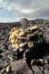
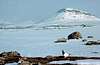
Halti (traditionally called "Haltiatunturi") is the highest mountain in Finland (1.328m above sea level), or it is rather a fell, "tunturi" in Finnish. Halti comes from the word "haltija," meaning a fairy. The Sami (traditional people of Lapland) name for Halti is "Halditsohkka."
The very summit of Halti is actually on the Norwegian side (at 1.361m called Haldefjäll), about 50m from the summit is a spur that is the high point of Finland. So, Halti is to Finland what Monte Bianco is for Italy: the high point of the country, although a spur of Mont Blanc. The highest mountain fully inside Finland is called Ridnitsohkka, (1.316m) about 10km ESE from Halti.
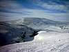
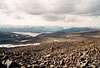
Halti is located in the extreme North-Western panhandle of Finland, and it is on the border with Norway. It is quite a popular trek during the summer months and climbing is not difficult since it is a walk-up mountain. The terrain itself is made up of large rocks with little of no earth visible. So, while summiting Halti itself is not difficult, getting there is a bit more demanding and it will take you several days.
 |
 |
 |
 |
 |
Getting There
Finland has a surprisingly dense air transportion network with hourly flights between Helsinki and Lapland. Best served from Helsinki is the City of Rovaniemi (capital of the Lapland Provice), as well as the ski-resort town of Kittilä. The closest airport to Halti is at Enontekiö, but there are only two flights per week from Helsinki. The two airlines with regular service to Rovaniemi and Kittilä are Finnair, the national airline of Finland, and it's competitor, Blue1, a member of the SAS Group.
Finnair (One World Alliance)
Blue1 (Star Alliance)
Finland Travel Information (Lonely Planet)
So, I would suggest flying either to Rovaniemi or Kittilä (about 1h 20min. flight from Helsinki) and renting a car from either airport. Most well-known international car rental companies (Hertz, Avies, Budget, etc.) serve these airports. Distance from Rovaniemi to Kilpisjärvi: 427km (driving time 5h30min.) and from Kittilä 276km (3h30min.)
Halti is located about 55km from the small town of Kilpisjärvi, and this is the best place to start. The normal route begins from Kilpisjärvi (South-West), and is very well marked. Halti is also accessible from the Norwegian side, so some trekkers prefer to do this and approach Halti from the North-West, and return via the normal route back to Kilpisjärvi, or vice versa. If you don't like to see any people on your trek, go from the Norwegian side.
If you want to get from Kilpisjärvi to Halti fast, and money is not an issue, there is a sea plane operator at Kilpisjärvi. From there you can hire a plane to take you to one of the many lakes in the area, from where it only takes you a few hours to trek to the top of Halti.
 |
 |
No Red Tape in Finland
No permits required. Even though Finland is a member of the European Union (since 1995) and Norway is not (although a member of the European Economic Area, EEA), there are no border control requirements on the Finnish-Norwegian border. There is a Finnish Customs/Border Control Station on the border at the town of Kilpisjärvi, but it is a rather quiet place.
When To Climb
Halti can be climbed year arround, but because of the extreme arctic conditions during winter, the most popular time to trek to the mountain is during the summer months from June-August. If you go before June, it's extremely wet and there's still snow on the ground. If you go after August, the temperatures are already a lot colder and the weather can be unpredictable.
During winter months, it is possible to get there by cross country skiis or by a snow mobile, which you can rent from the town of Kilpisjärvi. Since the area is a national park, you can only use your snow mobile on marked routes.
LOWEST AND HIGHEST TEMPERATURES OF THE MONTH C°
Monthly averages: highest temperature / lowest temperature (statistics for Sodankylä)
January -19 / -8
February -20 / -10
March -14 / -6
April -8 / 1
May -3 / 5
June 3 / 13
July 8 / 18
August 9 / 19
September 5 / 13
October 0 / 6
November -6 / 0
December -13 / -5
Source: "Ilmatieteenlaitos" (Finnish Meteorological Institute)
Camping In Huts or Tents
Camping is the only way to go since there are no hotels or huts with services on the route. Most people prefer to use their own tents since this guarantees you accomodation. Besides, it's more comfortable sleeping in your own tent because you have more privacy and there is more oxygen while you sleep. You need to have good equipment though, since nights can get cold. Have a sleeping bag with a rating of at least -15 degrees Celsius.
There are several modest huts on the route as well. These huts are owned by the Finnish Government and are free of charge to everyone. However, they can only accomodate up to 10 people, so not everyone is necessarily guaranteed a place. If everyone wants to sleep at a hut, then you have to negotiate on who stays. Obviously, if someone doesn't have a tent, he is allowed to stay. And, of course, someone can always sleep on the floor.
Huts are usually divided into two parts:
1) "Autiotupa" (in Finnish a hut that is deserted/not occupied ) is a side of the hut that is free and anybody can sleep there if there is room available. A list of autiotupa's on route to Halti:
- Saarijärvi, sleeps 10 people
- Kuontajoki, sleeps 10 people
- Meekonjärvi, sleeps 10 people
- Pitsusjärvi, sleeps 10 people
- Halti (old hut), sleeps 6 people
- Halti (new hut), sleeps 10 people
2) "Varaustupa" (in Finnish a reserve hut) is a side of the hut you can reserve for yourself only, but for this "luxury," you have to pay 9€/person/day to the Metsähallitus (Finnish Board of Forestry). They have a small office in Kilpisjärvi called "Luontotalo," nature house, from where you can reserve these cabins and get the key (tel. +358 (0)205647990 or if it is closed, Tunturi-Lapin Luontokeskus in Enontekiö +358 (0)205647950). All of the huts listed in the "Autiotupa" section have a reserve side to them except the old Halti Hut.
Services in the Town of Kilpisjärvi
 |
 |
 |
 |
Mosquitos and Variable Weather
Lots of mosquitos during the summer, so be prepared with mosquito repellent- and lots of it. In Finland, you can even buy t-shirts that say "Mosquitos, The Finnish Air Force!" so do take this warning very seriously. Mosquito hats are OK for camp, but not good with carrying a 20kg backpack in variable terrain. It will enevitably get on your way.
Rubber boots are also a must (rather than hiking boots) since the terrain is wet and you have to cross many shallow streams on your boots. Seakers good for camp.
Be sure to take warm clothing with you even during summer, since temperatures can drop to nearly 0 degrees Celsius, especially during nights. Be also prepared for rain or sleet, somethimes for days. But if you're lucky, the weather can also be nice: as hot as +30 Celcius during July-August! Have enough food for the several days it will take you for the trip there and back (110 km). There are no shops on route, so you cannot suppliment your supplies. Incidentally, you will not need to carry any water with you, since you can drink from a stream: guaranteed to be the cleanest and coolest water you have ever had (forget Evian here)!
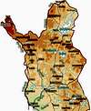
Current Weather in Lapland
Click on a desired section of Lapland to get local weather. For Halti, click North Western Finland. (Note the temperatures are in Celsius and wind speed in metres per second)
 |
Flora
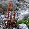
Most of the Kilpisjärvi-Halti Region can be classified as Low Alpine Vegetation consisting of several typical boreal forest species (dwarf shrubs, mosses, lichens) and some common alpine species. Abundant here are the Black Bearberry, Mountain Heath, Wild Azalea and Diapensia. Others include the Alpine Rush, Alpine Club Moss and Lappish Lousewort. Close to the many streams you will also find many species of meadow plants.
By the time you reach Middle Alpine Vegetation (above 900m), there are already some areas of snow, and there are also wind-swept areas with little or no snow. Here you will find mainly dry meadows of Fire Moss and some Three Leaved Rush. Dwarf shrubs have already become extremely rare at this altitude and the soil of bare mountain tops is mainly barren (with silicate rocks and humid climate).
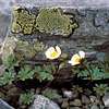
The mountains of the Halti region belong to the Scandinavian Mountains and are about 400million years old. Here, High Alpine Vegetation can be found at altitudes exceeding 1100m (including Halti itself). In these areas, there is no regular vegetation cover, only mosses and lichens between the bare stone boulders. The only plants to reach the High Alpine Level are the Glacier Buttercup and the Mountain Sorrel (see photos).
 |
 |
 |
Fauna
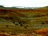
Wildlife in the area consists of Raindeer, there are about 200.000 of them in Lapland, so you are bound to run into some on your way to Halti. Other fauna include the Arctic Fox (Alopex lagopus), Wolverine (Gulo gulo) and about 110 species of birds such as the Red Grouse (Lagopus lagopus), Siberian Jay (Perisoreus infestans), European Golden Plover (Pluvialis apricaria) and others such as the Whooper Swan (Cygnus cygnus), which is the National Bird of Finland.
 |
 |
A List of All Finland's 1,000m+ (3,281ft) Peaks:
Finland is rarelatively low country and the only high ground can only really be found in the Kilpisjärvi-Halti region (Enontekiö Municipality). And yes folks, we are VERY jealous of Norway!!!
A list of all Finland's 26 over 1000m peaks:
1. Halti, 1,328m
2. Ridnitsohkka, 1,317m
3. Kiedditsohkka, 1,280m
4. Kovddoskaisi, 1,240m
5. Ruvdnaoaivi, 1239m
6. Loassonibba, 1,180m
7. Urtasvaara, 1,150m
8. Kahperusvaarat, 1,144m
9. Aldorassa, 1,130m
10. Kieddoaivi, 1,100m
11. Tuolljehuhput, 1,081m
12. Toskalharji, 1,080m
13. Marfevarri, 1,070m
14. Pihtsosjunni, 1,070m
15. Altovaara, 1,060m
16. Kuonjarvarri, 1,060m
17. Kodderassak, 1,060m
18. Loassonibba, 1,060m
19. Koddevarri, 1,050m
20. Tierbmesvarri, 1,040m
21. Saana, 1,029m
22. Jollanoaivi, 1,029m
23. Jeärdneoaivi, 1,020m
24. Aldovaggenmuvra, 1,020m
25. Meekonvaara, 1,010m
26. Urtaspahta, 1,010m
Jukka Ahonen - Sep 1, 2008 5:05 pm - Voted 8/10
When to goFor summer hiking experience from Kilpisjärvi to Halti, June is too early for most years. The best time to go is July and August. Keep in mind that the nights can get rather cold by late August, possibly under zero degrees, Celsius.
onidama - Dec 26, 2023 12:51 am - Hasn't voted
Mont Blanc is both the highest peak of France and ItalyThe following sentence should be corrected: „So, Halti is to Finland what Monte Bianco is for Italy: the high point of the country, although a spur of Mont Blanc.“ Contrary to Halti, the border between France and Italy runs through the water dividing line, that is the highest peak (4807,5 m.). This was established in the Treaty of Turin (1862) by which Savoy was sold by the Kingdom of Piedmont to France. Beliefs that this peak is located in France only were spurred by the false and unilateral military „Mieulet Map“ , which collides with that Treaty. Every mountain guide and mountain man/woman in Chamonix (fr) and Courmayeur (it) knows this story well.