
-
 3350 Hits
-
 81.18% Score
-
 13 Votes
|
|
Area/Range |
|---|---|
|
|
45.73464°N / 7.31589°E |
|
|
Overview
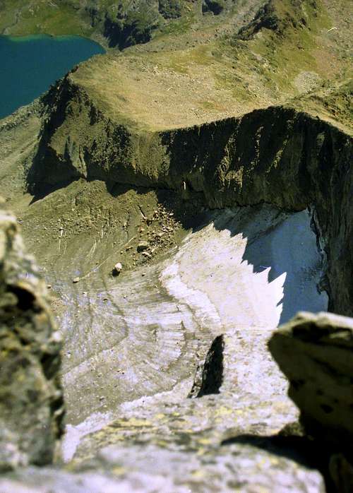
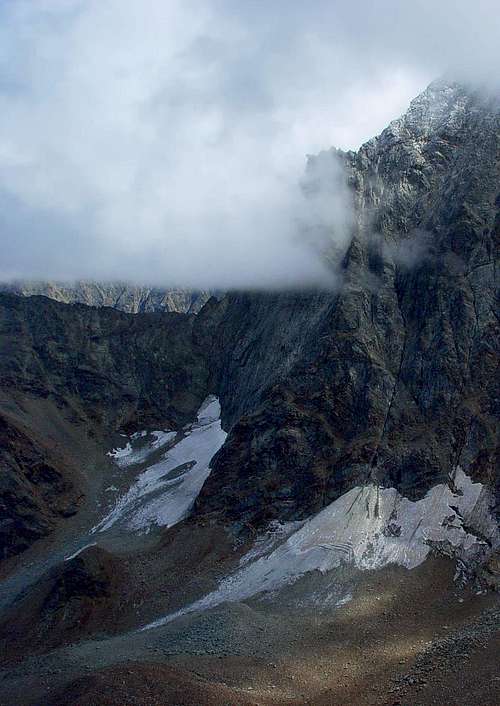
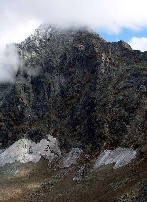
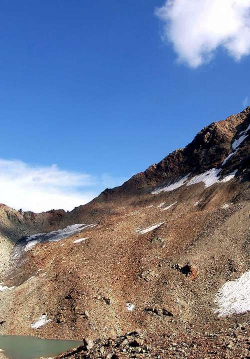
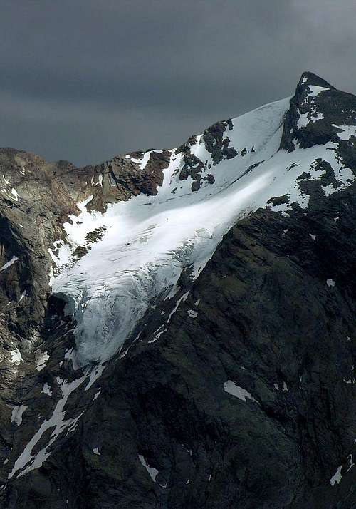
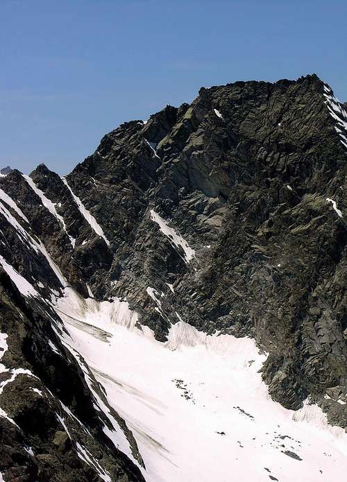
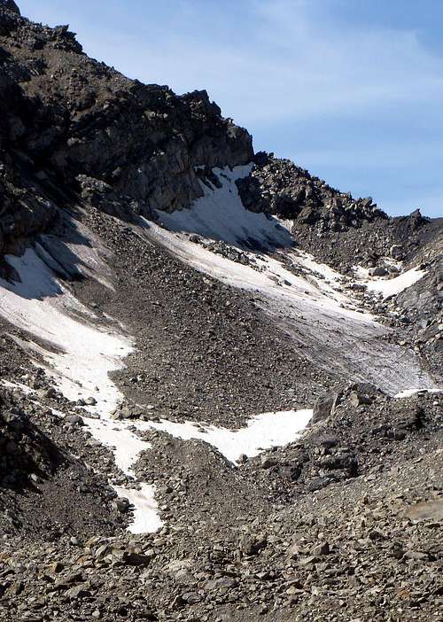
The phenomenon of pollution with its average temperature increase was most struck by what remained of ice in the Central Valley of the River Dora Baltea, for which reason the "Lower Valley" in practice, the glaciers have disappeared completely. In this great Southern area has remained practically the only Glacier of Rosa dei Banchi, but this is inherent in the Valley Champorcher and therefore falls outside the discourse of the Central Valley. From the East (Turin City) to meet one of them must go back to the Valley Fénis-Clavalité to the foot of the Punta Tersiva (3.515m) where it is, at the base of his North-northeast Wall, the namesake glacier, as evidenced by the bands of rock, in ancient times reaching up above the Grand-Alpe Pasture. Identical goes for the more than tiny Lavodilec Glacier, located at the base of the Northeast Slope of Punta del Tessonet and above the magnificent Lake Lavodilec, while on the opposite side, or on the Walloon of Saint Marcel, the Glacier Tessonet, first transformed into glacial-snowcapped, has totally disappeared. Now, the first two, are in the process of withdrawal evident, as the two small Eastern and Western Glaciers of Arpisson at the base of the great Wall North of Emilius and Glacier Blantzette, or better Blantsette, under the vertical wall of the West itself. All others in the same group have been reduced to a miserable thing, and some are, like those of the Petite Roise, Laures, Lussert (but this turned to the Cogne Valley), both West and South of the Peak Garin, completing missing; others like the Grande Roise, at the base of the West Face, or Leppe, below the homonym Summit, Northern Slope, permafrost are now in effect, though still retain the title of the glacier. On his South Side of Mount Emilius (3.559m) consists of the remains of the "Ancient Glacier of Mount Emilius", also known as the Glacier du Lac Gelé above this beautiful lake, situated between it and the Punta Rossa (3.401m) and the same, together with the wild, large and reddish moraines that descend to the foot of the Garin Pass (2.815m), in the Valley of Arbolle, are an effective witness to what was the real expansion of the ice in ancient times. Certainly not better is the situation in the "Upper Aosta Valley", where the two Glaciers of Mount Paramont (3.301m), with its beautiful and icy North Wall of over 800 meters, retreat more and more and also suspended its serac is now reduced to very little, compared to only 40 years ago. In addition, over the Conca d'Arpy, the Glacier of Comba Sorda on the Eastern side of the Mount Colmet (3.020m), the waters of which feed the splendid Lake Pietra Rossa, it was almost "eroded" by glaciologists than by temperatures. Fallen into oblivion, however there is still evident as shown by the crevasses, known by those who have risen to head to the Pass of Comba Sorda (Valley of La Thuile) in the Southeast Colmet.
Il fenomeno dell'inquinamento con relativo innalzamento della temperatura media ha maggiormente colpito quel poco che di glaciale rimaneva ancora nella Valle Centrale del Fiume Dora Baltea, per il qual motivo nella "Bassa Valle" in pratica i ghiacciai son completamente scomparsi. In questa grande area Meridionale in pratica é rimasto il solo Ghiacciaio della Rosa dei Banchi, ma questo é insito nella Valle di Champorcher e quindi esula dal discorso della Valle Centrale. Arrivando da Est (Torino) per incontrare un d'essi bisogna risalire la Valle di Fénis-Clavalité fino ai piedi della Punta Tersiva (3.515 m) ove trovasi, alla base della sua Parete Nord-nordest, l'omonimo ghiacciaio che, come testimoniano le fasce rocciose, nei tempi antichi arrivava insino al di sopra di Grand-Alpe. Identico discorso per il più che minuscolo Ghiacciaio di Lavodilec, sito alla base del Versante Nordest della Punta del Tessonet e soprastante il magnifico Lago di Lavodilec, mentre sul lato opposto, ovvero sul Vallone di Saint Marcel, il Ghiacciaio del Tessonet, dapprima tramutato in glacio-nevato, é totalmente scomparso. Ora, i primi due, sono in fase di evidente ritiro, come i due piccoli Ghiacciai di Arpisson alla base della grande Parete Nord dell'Emilius e del Ghiacciaio di Blantzette, o meglio Blantsette, sotto la verticale Parete Est del medesimo. Tutti gli altri nello stesso gruppo si sono ridotti a ben misera cosa ed alcuni sono, come quelli della Petite Roise, di Laures, di Lussert (ma questo rivolto alla Valle di Cogne), i due Ovest e Sud della Punta Garin, completante scomparsi; altri come quello della Grande Roise, alla base della Parete Ovest, o di Leppe, sottostante il Versante Settentrionale dell'omonima Punta, sono ormai in effetto permafrost, anche se mantengon ancora il titolo onorifico di ghiacciaio. Sul suo Versante Meridionale il Monte Emilius (3.559 m) presenta ancora i resti dell'"Antico Ghiacciaio del Monte Emilius", detto anche Ghiacciaio del Lac Gelé poiché al di sopra di questo bel Lago (2.956 m), posto tra lo stesso e la Punta Rossa (3.401 m); lo stesso, insieme alle grandi, rossicce e selvagge morene che calano fino ai piedi del Col Garin (2.815 m), nel Vallone di Arbolle, son valida testimonianza di qual fosse la reale espansione dei ghiacci in epoche ben più remote. Non certamente meglio é la situazione nell'"Alta Valle", dove i due Ghiacciai del Mont Paramont (3.301 m), con la sua bella e glaciale Parete Nord di oltre 800 metri, arretrano sempre di più ed anche il suo seracco sospeso é oramai ridotto a ben poca cosa, solamente rispetto a 40 anni orsono. Oltre, al di sopra della Conca d'Arpy, il Ghiacciaio di Comba Sorda sul fianco Orientale del Mont Colmet (3.020 m), le acque del quale alimentano lo splendido Lago di Pietra Rossa, é stato quasi più "eroso" dai glaciologi che non dalle temperature. Caduto nell'oblio, invece sussiste come dimostrano gli ancora evidenti crepacci, conosciuti da chi lo ha salito per dirigersi al Colle della Comba Sorda (Valle di La Thuile) a Sudest del Colmet.
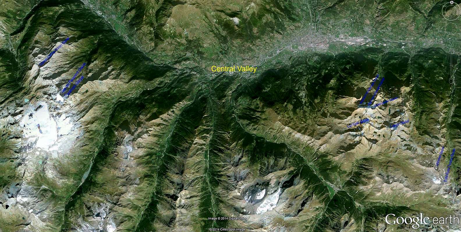
Dimensions and mass of glaciers in the Central Valley. The valley has ten glaciers as follows:Dimensioni e massa dei ghiacciai della Valle Centrale. La valle possiede dieci ghiacciai così ripartiti: |
|
Della Punta Tersiva Glacier
|
- Features: Uncertain
- Sector: Graie Alps (Central Valley)
- Surrounding summits: Punta Tersiva 3.515m
- Maximum altitude: 3.150m~
- Minimum altitude: 2.820m~
- Exposure: N
- Maximum length: 710m~
- Maximum width: 240m~
- Maximum extension: 0,076km²~ 7,6ha~
- Mean deep: 5m~*
- Maximum deep: 10/15m~**
- Activity: No sure
- Mean slope: -
- Caratteristiche: Incerte
- Settore: Alpi Graie (Valle Centrale)
- Vette principali: Punta Tersiva 3.515 m
- Quota massima: 3.150 m~
- Quota minima: 2.820 m~
- Esposizione: N
- Lunghezza massima: 710 m~
- Larghezza massima: 240 m~
- Estensione massima: 0,076km²~ 7,6ha~
- Profondità media: 5 m~*
- Profondità massima: 10/15m~**
- Attività: Incerta
- Inclinazione media: -
Lavodilec Glacier
|
- Features: Circus Glacier
- Sector: Graie Alps (Central Valley)
- Surrounding summits: Punta del Tessonet 3.264m
- Maximum altitude: 3.160m~
- Minimum altitude: 3.040m~
- Exposure: N
- Maximum length: 100m~
- Maximum width: 130m~
- Maximum extension: 0,006km²~ 0,6ha~
- Mean deep: -
- Maximum deep: -
- Activity: Accentuated retreat
- Mean slope: -
- Caratteristiche: Ghiacciaio di circo
- Settore: Alpi Graie (Valle Centrale)
- Vette principali: Punta del Tessonet 3.264 m
- Quota massima: 3.160 m~
- Quota minima: 3.040 m~
- Esposizione: N
- Lunghezza massima: 100 m~
- Larghezza massima: 130 m~
- Estensione massima: 0,006km²~ 0,6ha~
- Profondità media: -
- Profondità massima: -
- Attività: Ritiro accentuato
- Inclinazione media: -
Leppe Glacier
|
- Features: Uncertain
- Sector: Graie Alps (Central Valley)
- Surrounding summits: Punta di Leppe 3.305m
- Maximum altitude: 3.150m~
- Minimum altitude: 2.900m~
- Exposure: N
- Maximum length: 100m~
- Maximum width: 250m~
- Maximum extension: -
- Mean deep: -
- Maximum deep: -
- Activity: Strong retrat
- Mean slope: -
- Caratteristiche: Incerte
- Settore: Alpi Graie (Valle Centrale)
- Vette principali: Punta di Leppe 3.305 m
- Quota massima: 3.150 m~
- Quota minima: 2.900 m~
- Esposizione: N
- Lunghezza massima: 100 m~
- Larghezza massima: 250 m~
- Estensione massima: -
- Profondità media: -
- Profondità massima: -
- Attività: Forte arretramento
- Inclinazione media: -
Blantzette Glacier
|
- Features: Circus Glacier
- Sector: Graie Alps (Central Valley)
- Surrounding summits: Monte Emilius 3.559m
- Maximum altitude: 3.190m~
- Minimum altitude: 2.930m~
- Exposure: E
- Maximum length: 550m~
- Maximum width: 300m~
- Maximum extension: 0,095km²~ 9,5ha~
- Mean deep: 5m~*
- Maximum deep: 10/15m~**
- Activity: Accentuated retreat
- Mean slope: -
- Caratteristiche: Ghiacciaio di circo
- Settore: Alpi Graie (Valle Centrale)
- Vette principali: Monte Emilius 3.559 m
- Quota massima: 3.190 m~
- Quota minima: 2.930 m~
- Esposizione: E
- Lunghezza massima: 550 m~
- Larghezza massima: 300 m~
- Estensione massima: 0,095km²~ 9,5ha~
- Profondità media: 5 m~*
- Profondità massima: 10/15m~**
- Attività: Ritiro accentuato
- Inclinazione media: -
Arpisson orientale Glacier
|
- Features: Circus Glacier
- Sector: Graie Alps (Central Valley)
- Surrounding summits: Monte Emilius 3.559m
- Maximum altitude: 3.010m~
- Minimum altitude: 2.790m~
- Exposure: N
- Maximum length: 380m~
- Maximum width: 350m~
- Maximum extension: 0,045km²~ 4,5ha~
- Mean deep: -
- Maximum deep: -
- Activity: Retreat
- Mean slope: -
- Caratteristiche: Ghiacciaio di circo
- Settore: Alpi Graie (Valle Centrale)
- Vette principali: Monte Emilius 3.559 m
- Quota massima: 3.010 m~
- Quota minima: 2.790 m~
- Esposizione: N
- Lunghezza massima: 380 m~
- Larghezza massima: 350 m~
- Estensione massima: 0,045 km²~ 4,5 ha~
- Profondità media: -
- Profondità massima: -
- Attività: Ritiro
- Inclinazione media: -
Arpisson occidentale Glacier
|
- Features: Circus Glacier
- Sector: Graie Alps (Central Valley)
- Surrounding summits: Monte Emilius 3.559m
- Maximum altitude: 3.040m~
- Minimum altitude: 2.680m~
- Exposure: N
- Maximum length: 250m~
- Maximum width: 340m~
- Maximum extension: 0,03km²~ 3ha~
- Mean deep: -
- Maximum deep: -
- Activity: Retreat
- Mean slope: -
- Caratteristiche: Ghiacciaio di circo
- Settore: Alpi Graie (Valle Centrale)
- Vette principali: Monte Emilius 3.559 m
- Quota massima: 3.040 m~
- Quota minima: 2.680 m~
- Esposizione: N
- Lunghezza massima: 250 m~
- Larghezza massima: 340 m~
- Estensione massima: 0,03km²~ 3ha~
- Profondità media: -
- Profondità massima: -
- Attività: Ritiro
- Inclinazione media: -
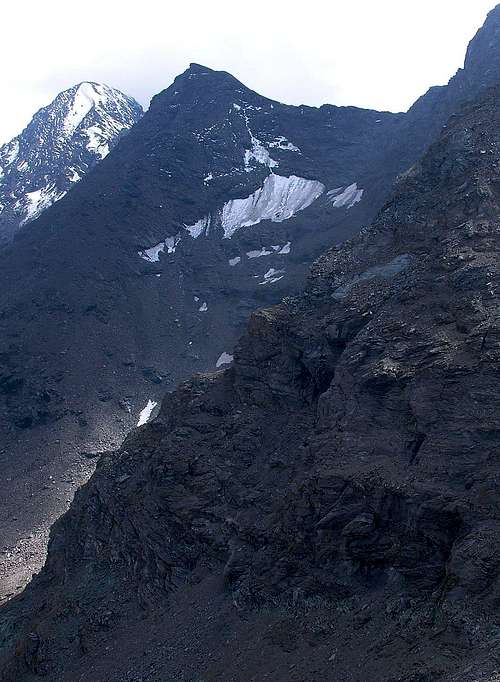
Lac Gelé Glacier
|
- Features: Circus Glacier
- Sector: Graie Alps (Central Valley)
- Surrounding summits: Punta Rossa dell'Emilius 3.401m
- Maximum altitude: 3.200m~
- Minimum altitude: 3.040m~
- Exposure: N-O
- Maximum length: 210m~
- Maximum width: 120m~
- Maximum extension: 0,015km²~ 1,5ha~
- Mean deep: -
- Maximum deep: -
- Activity: Not sure
- Mean slope: -
- Caratteristiche: Ghiacciaio di circo
- Settore: Alpi Graie (Valle Centrale)
- Vette principali: Punta Rossa dell'Emilius 3.401 m
- Quota massima: 3.200 m~
- Quota minima: 3.040 m~
- Esposizione: N-O
- Lunghezza massima: 210 m~
- Larghezza massima: 120 m~
- Estensione massima: 0,015km²~ 1,5ha~
- Profondità media: -
- Profondità massima: -
- Attività: Incerta
- Inclinazione media: -
Paramont Glacier
|
- Features: Glacier suspended and serac
- Sector: Graie Alps (Central Valley)
- Surrounding summits: Monte Paramont 3.301m
- Maximum altitude: 3.260m~
- Minimum altitude: 2.960m~
- Exposure: N
- Maximum length: 470m~
- Maximum width: 280m~
- Maximum extension: 0,08km²~ 8ha~
- Mean deep: 10m~*
- Maximum deep: 20/25m~**
- Activity: No sure
- Mean slope: -
- Caratteristiche: Ghiacciaio sospeso, seraccata
- Settore: Alpi Graie (Valle Centrale)
- Vette principali: Monte Paramont 3.301 m
- Quota massima: 3.260 m~
- Quota minima: 2.960 m~
- Esposizione: N
- Lunghezza massima: 470 m~
- Larghezza massima: 280 m~
- Estensione massima: 0,08km²~ 8ha~
- Profondità media: 10m~*
- Profondità massima: 20/25m~**
- Attività: Incerta
- Inclinazione media: -
Tête del Paramont Glacier
|
- Features: Circus Glacier
- Sector: Graie Alps (Central Valley)
- Surrounding summits: Testa del Paramont 3.185m
- Maximum altitude: 2.910m~
- Minimum altitude: 2.650m~~
- Exposure: N
- Maximum length: 600m~
- Maximum width: 250m~
- Maximum extension: 0,09km²~ 9ha~
- Mean deep: -
- Maximum deep: -
- Activity: Retreat
- Mean slope: -
- Caratteristiche: Ghiacciaio di circo
- Settore: Alpi Graie (Valle Centrale)
- Vette principali: Testa del Paramont 3.185 m
- Quota massima: 2.910 m~
- Quota minima: 2.650 m~
- Esposizione: N
- Lunghezza massima: 600 m~
- Larghezza massima: 250 m~
- Estensione massima: 0,09km²~ 9ha~
- Profondità media: -
- Profondità massima: -
- Attività: Ritiro
- Inclinazione media: -
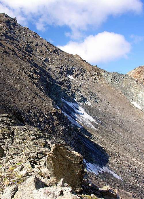
Colmet (Comba Sorda) Glacier
|
- Features: Circus Glacier
- Sector: Graie Alps (Central Valley)
- Surrounding summits: Mont Colmet 3.020m
- Maximum altitude: 2.890m~
- Minimum altitude: 2.740m~~
- Exposure: N
- Maximum length: 400m~
- Maximum width: 280m~
- Maximum extension: 0,085km²~ 8,5ha~
- Mean deep: 5m~*
- Maximum deep: 10m~*
- Activity: Not sure
- Mean slope: -
- Caratteristiche: Ghiacciaio di circo
- Settore: Alpi Graie (Valle Centrale)
- Vette principali: Mont Colmet 3.020 m
- Quota massima: 2.890 m~
- Quota minima: 2.740 m~
- Esposizione: N
- Lunghezza massima: 400 m~
- Larghezza massima: 280 m~
- Estensione massima: 0,085km²~ 8,5ha~
- Profondità media: 5 m~*
- Profondità massima: 10 m~**
- Attività: Incerta
- Inclinazione media: -
*The datum is not very sure **Not safe datum
*Dato poco sicuro **Dato non sicuro
Essential BOOKS
- "Le Pays de la Doire et son Peuple" di Augusta Vittoria Cerutti, Musumeci Editeur, Juin 1995.
- "Variazioni glaciali nel Gruppo del Monte Emilius"-"Glacial Variations in the Emilius Mountain Chain", by Alessandro Giusto Cardellina, pages various. Studies University of Turin, Mathematicals Faculty. Phisic and Natural Sciences/in Natural Sciences Course-Degree, Supervisor Prof. Michele Motta. One's thesis disputed in Turin, Apr 24th, 2009 (unpublished).
 |
External Links
- FONDAZIONE MONTAGNA SICURA Villa Cameron, località Villard de la Palud 1 Courmayeur (AO) Tel: 39 0165 897602 - Fax: 39 0165 897647.
- REGIONE AUTONOMA VALLE D'AOSTA the official site.
Acknowledgements
I am very grateful to my friend Osvaldo Cardellina for the text and the English translation.