
-
 26520 Hits
-
 74.92% Score
-
 5 Votes
|
|
Mountain/Rock |
|---|---|
|
|
69.47020°N / 19.87564°E |
|
|
Mountaineering, Skiing |
|
|
Spring, Summer |
|
|
6017 ft / 1834 m |
|
|
Overview
Jiehkkevarri is the highest mountain in the Lyngen Alps. It's been called the Mont Blanc of the North by some, and there are some similarities. It is the highest in its range, the summit is a glaciated dome, and the easiest routes are by traversing from other nearby peaks.Jeikkevarri is a frustrating mountain to photograph as it doesn't really stand out as it is surrounded by other peaks, and is a flat domed summit. The mountain is seldom directly climbed, almost all skiers and mountaineers approach via a different mountain, and then traverse over. This can make for a an excellent long ski traverse as several peaks can be summited on the same tour.
Jeikkevarri's walls are up to 1,300 meters in height. They are raked by avalanche, icefall from hanging glaciers, and rockfall. Yet, thanks to the connecting peaks, the summit can be reached without having to face these objective dangers. However, it's no hike: glacier travel is mandatory, and there are sections of avalanche prone slopes by any route.
Getting There
Driving directions are in the route descriptions.Route Overview
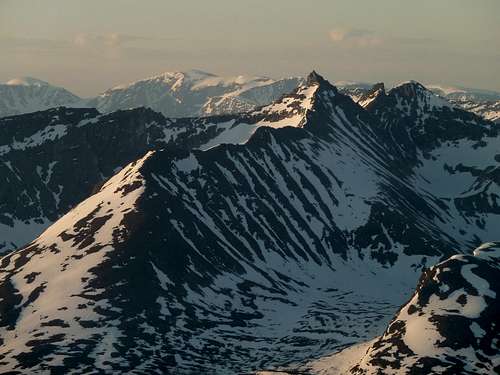
Many summits visible from Tromsdalstind.Hamperokken in the center foreground. The entire middagsaksle ridge route is visible. It's the long ridge split in sun\shade.The skyline in the back shows part of the Jiekkevarre traverse. Look from the summit of Hamperokken, behind and just to the left of the summit pinnacle is Holmbuktind. One can see the top of the skiing route. Follow the ramp of snow to the pass, and take a sharp right to get to the summit. From there, continue left to Jiekkevarre, the highest dome. Continue looking left to the gap and onward to Kveita, which is the next dome of snow on the far left edge of the picture.Also in this photo, in the foreground to the left of Hamperokken is Gabrielfjellet, which is an extension of Hamperokken, but can be considered a separate peak.The peak immediately to the right of Hamperokken is Bjørnskardalstind (trans. Bear Pass Valley Peak.)
Holmbukttinden (peak) is the most common route used on the ascent. It is commonly used for the descent as well. It offers the safest line to the summit, and the route to the Holmbukttind summit itself is a good ski run down. Not so enjoyable is the down and up traverse on the return from Jeikkehvare to Holmbukttind.
Blåisen: The Blue Ice Glacier is the most direct route to the summit. There are two short steeper sections that can be difficult to surmount without taking off the skis, and there is often crevasse danger so most parties rope up if unfamiliar with the route, or if it's later in the season. That said, most of the route can be skied up, and the crevasse danger is moderate as much of the route follows lateral moraines past the steeper icefalls.
Fugledalsbreen (glacier) is an often used descent route, and is occasionally used on ascent. The long ascending traverse from above the glacier, and the steep descent to the glacier dictate that this route is better on the descent.
Fornesbreen (glacier) is seldom used on the ascent, more commonly used on descent. This long North facing valley is a trudge going up, but a great easy descent on skis in early season. A poor choice in late season due to enormous piles of talus fans and moraines to hike over.
Lyngsdalen: The only commonly used route from the east. The advantage is that this route goes directly to the summit without ascending other peaks first. The valley approach, glacier ascent, and ridge climb make for great variety. The disadvantage is that it is long, and because of the rock scrambling, impractible to carry skis. Check photos and descriptions from AlexS on this page.
External Links
Photos and topos of the tour of Jiehkkevarri from Holmbukttinden to FornesbreenTour of JiehkkevarriPhotos and topos of the Holmbukttinden routeKugo.no website
Great Photos