
-
 9394 Hits
-
 77.48% Score
-
 8 Votes
|
|
Mountain/Rock |
|---|---|
|
|
69.40261°N / 19.32306°E |
|
|
Hiking, Mountaineering, Skiing |
|
|
Spring, Summer, Fall, Winter |
|
|
3871 ft / 1180 m |
|
|
Overview
There are 3 reasons to ascend this peak.1. The views from the top are truly extraordinary.
2. There is a bonafide path to the summit that is maintained.
3. The ski run in winter\spring is better than average. Much better.
Blåtind has always been a popular skiing mountain, but things really picked up after Tromsø bid for the 2018 Olympic games. It was proposed that the mountain be developed to host the Downhill and Super G events. Now it's so popular that usually all you need to know is where to park, and then just follow the ski tracks from there.
The name Sleeping Soldier comes from viewing the peak in profile from the other side of Balsfjord. From a distance one can make out the profile of a WWII era soldier lying on his back.
Getting There
From Tromsø: Drive on E8 (the only highway out of town) for about 50km. After driving past Ramfjord, drive through the lovely valley called Lavangsdalen. The end of this valley opens up to Balsfjord, which is a very large and wide fjord. Just before the water becomes visible there is a secondary road that turns off to the left. Take this road and follow it until it turns sharply to the left to get around a long ridge. This ridge is the beginning of the climb. There is parking for about 8 cars here.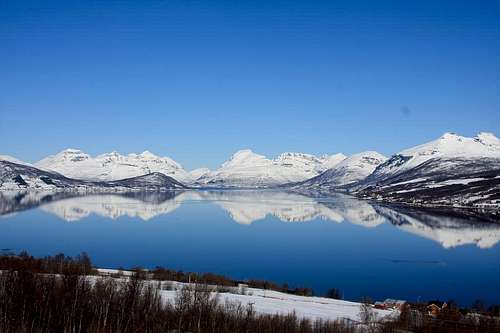
From E6 and all points south: Turn onto E8 at Nordkjosbotn, follow signs to Tromsø. Turn off at a sign for Laksvatn\Jøvik. There is a Mobile Bunker Oil station here. Turn immedietly left to get on the old highway. Follow this road until it makes a sharp right turn to get around the west end of a wooded ridge. There is parking just on the other side of this turn.
Red Tape
There is a sometime 50 kroner parking fee if you can find a way to pay it.Route Description.
Since there is only one documented route, I'm including it here instead of adding an extra route page.Begin at the very toe of the wooded ridge that is lying on a west-east axis. The top of the ridge is cleared of trees, which is a neccessity for winter descents to be enjoyable.

Follow the ridge up to treeline into a series of wide bowls, almost a plateau. Skirt this plateau, staying above the cirque that is below and to the climbers left (west)

Directly ahead is the main summit with a large chute or bowl going down the center, and ridges on either side. The ascent route for summer and winter is to follow the right or more eastern ridge.


Summer descent follows the same, whereas skiers drop into the bowl for a fantastic descent with lots of southern exposure to the sun, and open views out over Balsfjord.

Skiers: Be sure on the descent to keep up a good speed so that you can clear the plateau area without getting too close to the edge of the cirque.
External Links
kugo 666This is a great website, easy to translate thanks to google, with a clear topo overlay of the route.
Northern Playground
Has excellent photos with route overlays.
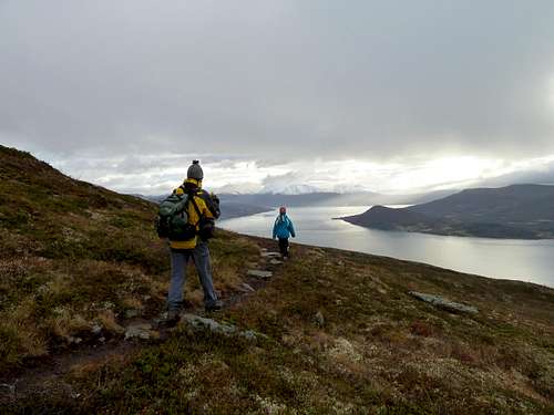
Hiking Blåtind in the fall. Balsfjord below.