
-
 10811 Hits
-
 74.92% Score
-
 5 Votes
|
|
Mountain/Rock |
|---|---|
|
|
69.55500°N / 19.36580°E |
|
|
4455 ft / 1358 m |
|
|
Overview

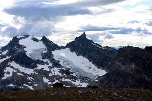
The seldom seen north faces of Bjørnskardalstinden and Hamperokken. New routes anyone?
 |  |
Getting There
The largest city in the area is Tromsø. From Tromsø drive south on E8 for almost 30km until seeing signs to the left for highway 91. This road ends at a ferry to Breivikeidet. Drive along highway 91 until passing the EISCAT heating prosjekt sign. A large dish antenna is visible, as well as other research facilities. To the right is a large valley. This is Bjørnskardalen. There are small dirt roads that go in a few hundred meters on either side of the river. The right hand side goes in deeper, but then you need to cross the river. The left is a private drive, but the owner is friendly to climbers and hikers.There are two routes from this approach. First is the Northwest Ridge of Stortinden. From parking at the river, head left up through the birch forest until reaching the rounded ridge, which gets sharper as one ascends, finally turning into shaky third class on loose rock. Not recommended, but plenty exciting. The easier route is the south face. To reach it, see the route description.
The alternative approach is from the East. It isn't much longer, and the ascent is more gradual. Continue the same driving directions as above, but drive past the EISCAT station for around 18k, until reaching a sign 'Sjursnes' to the right. Follow this road past a lake called Nakkevatnet, and park at some cabins. Due East of the lake is a wide open valley called Namdalen. Hike about 6k up this valley until reaching the pass. From here, hike downhill about 300 meters through talus to reach the easiest southern slope, follow it directly to the summit of Bjørnskartinden. This is a good ski trip, with moderate avalanche danger.
Map: From Statens Kartverk. www.statkart.no. You'll need Map 1534 II Ullsfjord. 1:50000.
 |
Red Tape
No fees, no rangers, no trails, no rescue. It may be a good idea to ask permission if parking in a private driveway. The no rescue part is only partially true, there is a volunteer rescue group, and access to a helicopter, but it's nowhere near the Alps of Switzerland, nor as hodgepode as a National Forest - National Guard - Local Sheriff American "system".When To Climb
February to May if climbing\skiing the south face. This valley has seen large rockslides recently, good snow cover is essential. The North ridge can be climbed from February to October.External Links
Northwest Ridge Route: Kent Hugo finally completed the entire Northwest Ridge Route in 2015. Text in Norwegian, but plenty of good photos. Again, this leads to the subsummit Stortinden, on the right side of the Hamperokken\Bjørnskardalstind cirque, not to the summit of Bjørnskardalstind. In fact, Kent Hugo admits to attempting a continuation of the traverse from Stortind to Bjørnskardalstind, but his party had had enough of the loose rock, and several breaks in the ridge looked too technical for scrambling.