
|
|
Mountain/Rock |
|---|---|
|
|
45.68755°N / 11.14393°E |
|
|
Veneto |
|
|
Hiking, Mountaineering, Ice Climbing |
|
|
Spring, Summer, Fall, Winter |
|
|
6483 ft / 1976 m |
|
|
Overview
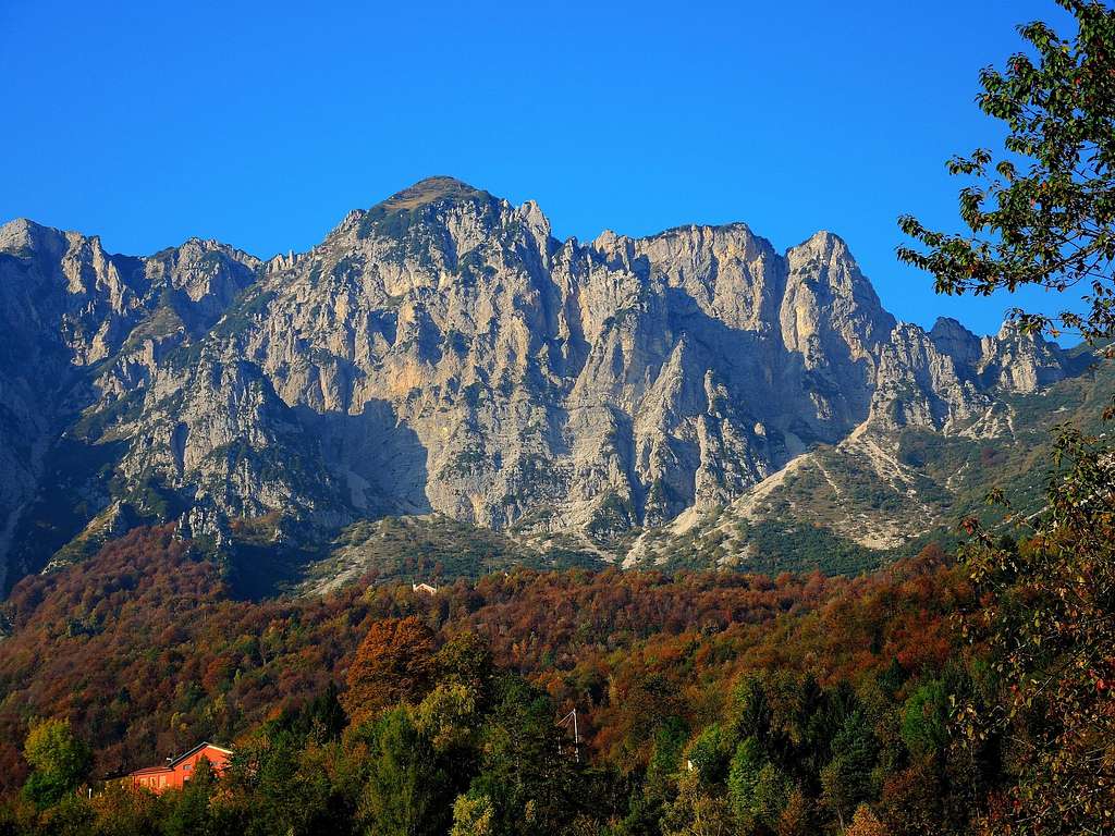
Monte Zevola 1976 m
Monte Zevola is a massive mountain located in the Southern sector of the Prealpi Vicentine. It's the highest peak of the Catena delle Tre Croci, which Northern limit and point of contact with the largest Carega Group is the Passo Tre Croci, erroneously called Passo della Lora. Monte Zevola appears as an imposing mountain especially if seen from the side of Recoaro (North), where it projects a steep rock wall crossed by two "vaj", the Vajo Battisti and the Vaio dell'Acqua. The "vaj" are steep gullies, characteristic of the Prealpi Vicentine, that in winter are filled with snow because of the considerable snowfall of the group and offer interesting ice-climbs.

|

|
Monte Zevola is mainly frequented along the two Normal Routes starting from Rifugio Battisti alla Gazza. During the winter the Vajo Battisti - vajo means "gully" - and the Vajo dell'Acqua are often attended. Monte Zevola is also climbed starting from the Veronese side of the Val Fraselle. The summit of the mountain is known to be very scenic: in addition to the panorama over the close groups of Carega and Pasubio, the view sweeps over the Dolomites, Monte Baldo and Adamello group.

Getting There
The starting point to climbing both the two Normal Routes on the side of Recoaro (Vicenza) and the winter climbs to the vaj is the Rifugio Battisti alla Gazza.

Road access
From Vicenza drive on the state road 246 Valdagno - Recoaro, in Recoaro follow the direction to Località Gazza, taking the road entering the Valle Agno di Lora up to the Trattoria Obante, then to the Refuge Battisti where the road ends. Park the car 200 meters before the hut, where there is a large parking lot. Be aware that in winter when the road is covered with snow you can drive till the Trattoria Obante, beyond which the road is closed.
Normal route across the Passo Tre Croci and the Passo Zevola
Monte Zevola Normal route via Passo Tre Croci
Summit quote: 1976 m
Difficulty: E
Difference in level: 700 m from Rifugio Battisti
Exposition: mainly South-East, the final ascent to the summit is facing NW
Time required: 4 hours round trip
Starting point: Rifugio Battisti

|

|
From the parking lot soon you reach the Rifugio Cesare Battisti 1265 m. On the right of the refuge it starts the path 110 to Passo Tre Croci. Between darf pines ("mughi" in italian) and gravels descending from Monte Plische and Monte Tre Croci, this trail climbs with a regular slope and several hairpin bends to the Tre Croci Pass 1716 m (signposts on the pass).

|

|
When you get here, turn sharply to the left and at first slightly uphill then orizontally follow the path cutting the grassy slopes that descend from Monte Tre Croci. Arrived at the Passo Zevola 1820 m you ignore the main path that goes straight and on traces turn to left on a trail that climbs up the steep grassy slope and leads up to the cross, where is located the summit book. This point is not the real summit of Monte Zevola, but a fore-summit.

|

|
Continuing slightly to the left along the easy and evident grassy ridge you reach the true summit (pole) within 5 minutes.
Descent: reversing the same route
Hiking and scrambling scale
T - Turistico (Tourist): Itineraries on wide, clear and well worn paths, sometimes on mule tracks or gravel roads. The routes are never exposed, don't give any orientation problems and don't exceed 2500 meters of altitude. Suitable also for children
E - Escursionisti (Hikers): Itineraries on marked trails, even narrow and with possible steep and impervious sections. They are never exposed and don't give any orientation problems. They can tread different kinds of ground, such as forests, gravel, meadows, pastures, easy rocks, etc.). They form the majority of the trails that wind up in the mountains and require a certain habit to walk; you need equipment suitable for the altitude and resistant footwear with soles suitable for rough terrain
EE - Escursionisti Esperti (Experienced Hikers): Itineraries for hikers with experience and good knowledge of the mountain. Some of these paths may have exposed sections, however brief, which require firm foot and no dizziness. They require the ability to adapt to particular terrain, such as steep grassy slopes or stretches of rocks with difficulties that can reach the 1st degree of the UIAA scale. They can also reach high altitudes (3000 m or more). Sometimes they may include unmarked sections, requiring a good sense of orientation. Snow slopes are possible, however which can be overcome without specific mountaineering gear (rope, harness, crampons, ice-axe)
EEA - Escursionisti Esperti con Attrezzatura (Experienced Hikers with equipment - The same as EE, in addition these routes require the use of via ferrata equipment (lanyards, harness, carabiners, heat sink, helmet). This kind of itineraries range from the trails with short easy and not much exposed sections, previously equipped with fixed ropes and iron pegs, to the true and more difficult Via Ferratas climbing on rocky walls or on aerial ridges and ledges, previously equipped with long stretches of iron ropes, iron steps, ladders without which proceeding would constitute a real climbing. It is necessary to know how to use the technical equipment and have a certain habit of exposure and mountaineering terrains.
Red Tape
No permits required, no fees. During the winter months (with snow) the road to the refuge is open only up to the Trattoria Obante.
When to Climb
From the end of April from middle November.
Hut

The hut is located at an altitude of 1265 m in the municipality of Recoaro Terme in the Piccole Dolomiti group. It is located at the foot of the Carega massif, under the Passo Tre Croci on the grassy plateau called La Gazza, at the base of the scree that descend from the Passo delle Tre Croci. It is owned by the CAI section of Valdagno. It has 34 beds and is open from June to September. The rest of the year only on holidays and pre-holidays.
Bibliography
“Piccole Dolomiti – Pasubio” Gianni Pieropan - Collana Guide dei Monti d’Italia, CAI TCI
"Rovereto - Monte Pasubio" - Kompass map 1:50000