
-
 11923 Hits
-
 93.58% Score
-
 43 Votes
|
|
Mountain/Rock |
|---|---|
|
|
45.73752°N / 11.17894°E |
|
|
Veneto, Trentino |
|
|
Mountaineering, Trad Climbing, Sport Climbing, Scrambling |
|
|
Spring, Summer, Fall |
|
|
5883 ft / 1793 m |
|
|
Overview
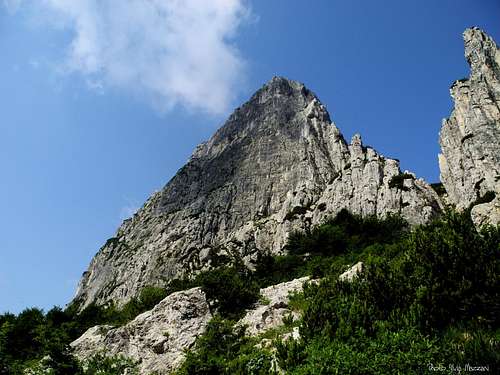
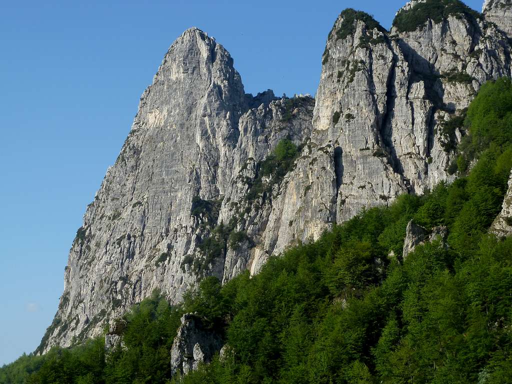
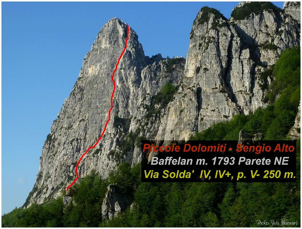
Baffelan 1793 m

The charming pre-alpine group of Piccole Dolomiti (Little Dolomites) keeps some pearls. Baffelan is one of these, an imposing and beautiful limestone tower located in the Sengio Alto Subgroup, the central chain in the Little Dolomites. By means of the mighty shape, the height – 350 meters - the remarkable highlight and the steepness of its walls Baffelan represents the emblem of the whole range. The peak shows a wide and majestic East face overlooking the Strada del Re (King’s Road), a yellow South face and a steep North face; the West side has a a shorter wall and joins the Sengio Alto notched ridge. On this peak we can count numberless high class climbing routes on a “dolomia” of very good quality; in addition to the pre-existent classic and hystorical routes, some other new ones were climbed in last ten-years period.
L'affascinante gruppo prealpino delle Piccole Dolomiti racchiude alcune perle. Una di queste è il Baffelan, imponente e bella torre dall'aspdetto dolomitico situata nel sottogruppo Sengio Alto, la catena centrale delle Piccole Dolomiti. Per le sue forme maestose, la verticalità e l'altezza delle pareti - 350 metri - il Baffelan rappresenta l'emblema dell'intero gruppo delle Piccole Dolomiti. Si distinguono l'ampia e maestosa parete Est che domina la Strada del Re, una parete Sud giallastra e una ripida parete nord; il versante Ovest invece non ha pareti cospicue e si unisce al crinale dentellato del Sengio Alto. Su questa cima si contano innumerevoli vie di arrampicata d'alta classe su una "dolomia" di ottima qualità; si aggiungono alle vie preesistenti classiche e storiche, diverse altre aperte nell'ultimo decennio.
Getting There
Road access
There are two different possibilities to approach Baffelan. The itinerary described below allows a faster walking approach:
1 – From SE side (Vicenza province): follow A4 Motorway, exit Montecchio Maggiore and take the road to Valdagno, Recoaro and Passo di Campogrosso (47 km. from Montecchio Maggiore); some hundred meters before getting to Passo di Campogrosso take the King’s Road on the right and park the car near the bar closing the road. The walking approach if coming from SE side is quite faster then the next one.


2 – From NW side (Trento province): follow A22 Autobrennero Motoway, exit Rovereto and take the SS46 rising along the Vallarsa; after the interesting Eremo di San Colombano, the road is rising across some small villages like Valmorbia, Anghebeni and Raoxi and at the end reachs Pian delle Fugazze m. 1162 (km. 27 from Rovereto). From the pass, situated on the border between Trento and Vicenza provinces, follow for a few meters the road towards Vicenza and sudden leave it, turning to right on the King’s Road (Strada del Re, an old road suitable for vehicles only for some kilometers) leading to Malga Cornetto. Parking lot.

Walking access
From Passo Campogrosso - Follow the Strada del Re (King’s Road), skirting the East faces of the Sengio Alto, for few hundreds of meters and park the car near the bar which closes the road. After reaching Malga Baffelan follow the trail toward the E face (20 min.)
From Pian delle Fugazze - The approach from Passo delle Pian delle Fugazze on the Trentino side is much longer but interesting. Reached Malga Cornetto (paid parking) continue along the Strada del Re by foot. The road once was an important link between the two sides, it's closed to traffic and turned into a path. At the fork with the road to Pasubio Military Sanctuary on the left, carry on along the main road soon closed by a barrier. Continue along the road, pass the start of the CAI path 175 for the Sella dell'Emmele (on the right) and after a few hundred meters of road you reach an area affected by an old landslide, where now you will find a suspension bridge that allows the crossing of the landslide: the "Ponte Avis", known as Tibetan bridge, stretched on steel ropes, very airy, narrow, swinging above the deep valley. After crossing the bridge and after a few more bends along the road, the road gets Malga Baffelan in front of the imposing East face of the Baffelan. From a hairpin below the wall a short trail starting from the hairpin leads below the East face (50 min).
Accesso automobilistico
Ci sono due diverse possibilità per l'avvicinamento al Baffelan. L'itinerario descritto di seguito consente un approccio a piedi più veloce:
1 - Dal versante SE (provincia di Vicenza): seguire Autostrada A4, uscire a Montecchio Maggiore e prendere la strada per Valdagno, Recoaro e Passo di Campogrosso (47 km. da Montecchio Maggiore); qualche centinaio di metri prima di arrivare al Passo di Campogrosso si prende a destra la Strada dei Re e si parcheggia in prossimità della sbarra che chiude la strada. L'avvicinamento a piedi se si proviene dal lato SE è molto più veloce del successivo
2 - Da NW (provincia di Trento): seguire l'Autostrada A22 Autobrennero, uscire a Rovereto e prendere la SS46 che sale lungo la Vallarsa; dopo l'interessante Eremo di San Colombano, la strada attraversa alcuni piccoli paesi come Valmorbia, Anghebeni e Raoxi e raggiunge Pian delle Fugazze m. 1162 (km. 27 da Rovereto). Dal passo, posto al confine tra le province di Trento e Vicenza, si segue per pochi metri la strada in direzione Vicenza e la si abbandona immediatamente, svoltando a destra sulla Strada del Re, antica strada percorribile solo per alcuni chilometri e raggiungendo Malga Cornetto. Parcheggio.
Avvicinamento a piedi
Dal Passo Campogrosso - Seguire la Strada del Re, costeggiando le pareti Est del Sengio Alto per poche centinaia di metri e parcheggiare in prossimità della sbarra che chiude la strada. Raggiunta Malga Baffelan si segue il sentiero verso la parete E (20 min.)
Da Pian delle Fugazze - L'avvicinamento dal Passo delle Pian delle Fugazze sul versante trentino è molto più lungo, ma interessante. Raggiunta Malga Cornetto (parcheggio a pagamento) proseguire a piedi lungo la Strada del Re. La strada, che un tempo era un importante collegamento tra i due versanti, è oggi chiusa al traffico e trasformata in sentiero. Al bivio con la strada per il Santuario Militare del Pasubio sulla sinistra, si prosegue sulla strada principale che presto è chiusa da una sbarra. Si prosegue lungo la strada, si supera l'attacco del sentiero CAI 175 per la Sella dell'Emmele (a destra) e dopo poche centinaia di metri di strada si giunge in una zona interessata da una vecchia frana, dove ora si trova un ponte sospeso che permette l'attraversamento della frana: il "Ponte Avis", detto ponte tibetano, teso su funi d'acciaio, molto aereo, stretto e oscillante sopra la profonda valle. Dopo aver attraversato il ponte e dopo alcuni tornanti lungo la strada, la strada raggiunge Malga Baffelan davanti all'imponente parete est del Baffelan. Da un tornante sotto la parete un breve sentiero che parte dal tornante conduce alla base della parete Est (50 min).
History
First summit ascent: Giuseppe Bolfe and pals on June 24th 1877 along the West standard route
All the routes on Baffelan


South face
- Via Soldà IV, 180 m.
- Via Casara III, IV, 300 m.
East Face
- Via N. Soldà
- Via Compagnia
- I Segreti del Baffelan IV, V, VI-, 400 m.
- Sem
- Ceneri nel Vento VI, VII, VIII+ (A0), 370 m.
- Via del Piacere V, V+, a single move grading VI, 350 m.
- Via Boschetti-Zaltron
- Alpinismo Radicale VIII-, A1 (VII obbl.), 345 m
- Via Berti - Carugati III+, a single move grading IV, 330 m. - The first itinerary on the east face of the Baffelàn climbed in 1908 by the great pioneer of the Dolomites Antonio Berti, it follows the easiest points of the face
- Via Carlesso IV, V, a single move grading V+, 290 m.
North-East Ridge
- Via Tranquillo e Placido VI, VI+, VII (A0), 280 m.
North-East face
- Superbaffelan V, VI, VI+, 270 m.
- Soldà Pillar IV, V-, 250 m.
North face
- Via Thiene IV, V, VI+, VII-, 170 m. - Route running directly on the smooth North pillar of Baffelàn, opened in 1954 by Zaltron, Finozzi and Dalle Carbonare.
- Via Vicenza III+, IV-, 170 m.
- Via Verona III+, IV-, IV, V the start, 170 m. - Classic mountaineering route of medium-low difficulty, opened by Padovan, Rossi and Bortolan in 1927. It follows an obvious system of chimneys to reach the top of the pillar where it joins Via Soldà
- Via Bentornato IV, V, VI, 220 m. - Well-protected mountaineering route, opened in 2007 by Silvio Scandolara and Arturo Franco Castagna, to the right of Via Verona.
- Via Ferrara IV, V, A1 170 m. - Historical itinerary, opened in 1971 by G. Soldà and A. Gorini which follows the edge of the north-west corner starting from the Vajo del Baffelàn.
Baffelan Normal route on the West side
Baffelan Normal Route West side
Summit altitude: 1793 m
Difficulty: Alpine F
Difference in level: 330 m
Starting point: Rifugio Giuriolo - Passo Campogrosso 1460 m
Short and fun route on solid rock with good holds, leading to the beautiful and panoramic summit
From Rifugio Giuriolo at Campogrosso take the path 13-E5. At the second junction leave the main path and turn to right taking the path 14 rising up to Passo di Gane. From here, turn left going up to Forcella del Baffelan along a path winding among the mountain pines.
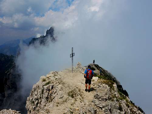
From the saddle climb the first rocks (I UIAA), then on a trace reach a scree gully, climb it and cross to the left to climb an easy crack and a dihedral (II-), bypass a slab on the right and through gullies (I) and a short trace up to the flat top with a huge cross.
Descent: reversing the route
Via Normale da Ovest
Quota vetta: 1793 m
Difficoltà: F
Dislivello: 330 m
Punto di partenza: Rifugio Giuriolo - Passo Campogrosso 1460 m
Itinerario breve e divertente su roccia solida con buoni appigli, che conduce alla bella e panoramica vetta
Dal Rifugio Giuriolo a Campogrosso si prende il sentiero 13-E5. Al secondo bivio si lascia il sentiero principale e si svolta a destra prendendo il sentiero 14 che sale fino al Passo di Gane. Da qui si svolta a sinistra salendo alla Forcella del Baffelan lungo un sentiero che serpeggia tra i mughi. Dalla sella si salgono le prime roccette (I UIAA), poi su traccia si raggiunge un canalone ghiaioso, lo si risale e si traversa a sinistra per salire una facile fessura e un diedro (II-). Si aggira una placca a destra e si attraversa un canale (I). Una breve traccia porta alla sommità piatta caratterizzata da una grande croce.
Discesa: per lo stesso itinerario
Baffelan Normal Route accross Boale del Baffelan
Baffelan Normal Route across Boale del Baffelan
Summit altitude: 1793 m
Difficulty: Alpine F
Difference in level: 330 m
Starting point: Strada del Re, Passo Campogrosso 1460 m
An interesting route starting from the Strada del Re and involving a short equipped section, getting Forcella del Baffelan. The last part is the same as described in the previous point.


Report: take the Strada del Re (King’s Road) and follow the trail toward Malga Baffelan, then head towards the walls, skirt the East face of Baffelan and reach on the right a built stone-wall. Climb the rocks on the left of the wall with the aid of an iron chain and enter the Boale del Baffelan, following a trail on steep gravel ground, leading to Passo del Baffelan (junction with the Arroccamento trail, signposts). Turn to left (South) and follow the Arroccamento trail to the Forcella del Baffelan. From here a short scramble up easy rocks (I, II) leads to the summit cross (1 and a half hour from the Strada del Re).
Via normale attraverso il Boale del Baffelan
Quota vetta: 1793 m
Difficoltà: F
Dislivello: 330 m
Punto di partenza: Strada del Re, Passo Campogrosso 1460 m
Un percorso interessante che parte dalla Strada del Re e comporta un brevissimo tratto attrezzato, arrivando alla Forcella del Baffelan. L'ultima parte è la stessa descritta al punto precedente.
Prendere la Strada del Re e poi il sentiero verso Malga Baffelan, quindi dirigersi verso le pareti, costeggiare la parete est del Baffelan e raggiungere sulla destra un muretto costruito in pietra. Salire le roccette a sinistra della parete con l'aiuto di una catena di ferro ed entrare nel Boale del Baffelan, seguendo un sentiero su ripido ghiaione, che porta al Passo del Baffelan (incrocio con il sentiero di Arroccamento, segnaletica). Svoltare a sinistra (Sud) e seguire il sentiero di Arroccamento fino alla Forcella del Baffelan. Da qui una breve arrampicata su facili roccette (I, II) porta alla croce di vetta (1 ora e mezza dalla Strada del Re).
Views of Baffelan
 |
 |
 |
 |
Climate and nature

, Little Dolomites")
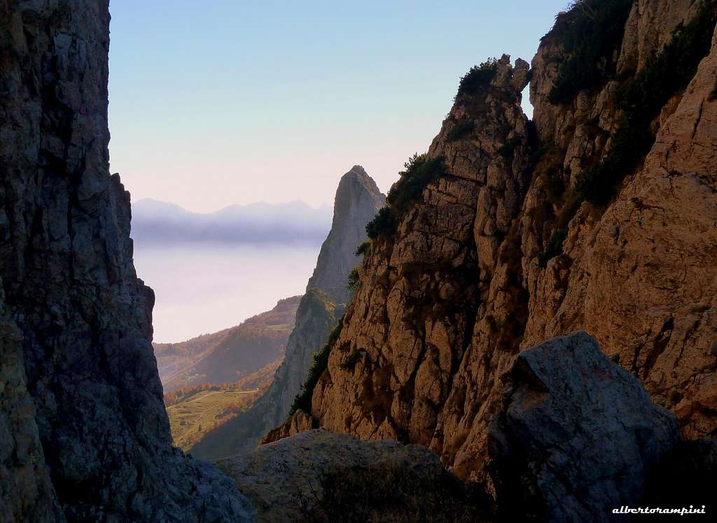
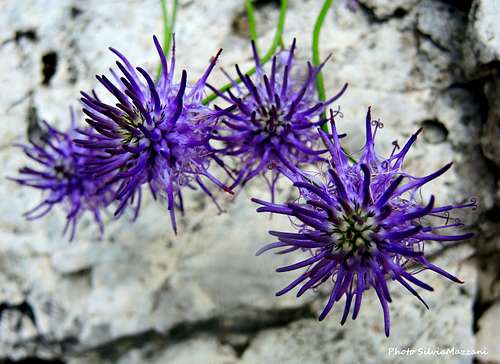
The Piccole Dolomiti are home of a local micro-climate, due to the high contrast between the NW side, colder and dry, and the SE side, warmer and wet. This situation is the cause, especially in the summer time, of frequent fogs along the East sides. In Spring we can observe a wonderful flowering of many species, some of which autocthon. Fall is a wonderful season to climb and hike, in reason of the presence of a mixed wood, surroundings the Sengio Alto Subgroup, giving an amazing look to the landscape.
Le Piccole Dolomiti presentano un microclima locale, dovuto all'elevato contrasto tra il versante NW, più freddo e secco, e il versante SE, più caldo e umido. Questa situazione è la causa, soprattutto nel periodo estivo, di frequenti nebbie lungo il versante est. In primavera possiamo osservare una meravigliosa fioritura di molte specie, alcune delle quali autoctone. L'autunno è una stagione meravigliosa per le arrampicate e le escursioni, per la presenza di un bosco misto, che circonda il sottogruppo del Sengio Alto, donando al paesaggio un aspetto sorprendente.
, Little Dolomites")
")
Sengio Alto and Sentiero di Arroccamento


The Sengio Alto is a mountain range, rather brief, with towers and pinnacles of dolomitic appearance, located between Passo di Campogrosso and Pian delle Fugazze. Its Eastern side is more vertical and rocky, while the Western one has shorter rocky walls and less steep slopes that descend to the woods and meadows below.
The Sengio Alto is crossed by a panoramic path, called Sentiero di Arroccamento dating back to the First World War. This is an extraordinary old military path, winding between the peaks of Sengio Alto Subgroup and crossing it from Malga Cornetto m. 1220 to the Refuge Toni Giuriolo on Passo di Campogrosso m. 1456. The path was realized by the Italian Military Engineers Corp during the First World War. The path has stretches carved into the rock and several tunnels and gives really characteristic glimpses of the surrounding walls and spires. It can be accessed from both sides, Vicenza and Trento: from the Refuge Campogrosso through the Passo delle Gane or from the Sentiero del Re across the Boale del Baffelan (Vicenza) and from Malga Cornetto (Trento) through the Selletta di Nord-Ovest or the Sentiero dell'Emmele.
Il Sengio Alto è un gruppo montuoso, piuttosto breve, con torri e pinnacoli di aspetto dolomitico, situato tra il Passo di Campogrosso e il Pian delle Fugazze. Il suo versante orientale è più verticale e roccioso, mentre quello occidentale presenta pareti rocciose più corte e pendii meno ripidi che scendono verso boschi e prati sottostanti. Il Sengio Alto è attraversato da un sentiero panoramico, chiamato Sentiero di Arroccamento risalente alla prima guerra mondiale. Si tratta di uno straordinario antico sentiero militare, che si snoda tra le vette del Sottogruppo del Sengio Alto e lo attraversa da Malga Cornetto m. 1220 al Rifugio Toni Giuriolo al Passo di Campogrosso m. 1456. Il percorso fu realizzato dal Corpo degli Ingegneri Militari Italiani durante la prima guerra mondiale. Il percorso ha tratti scavati nella roccia e diverse gallerie e regala scorci davvero caratteristici sulle mura e sulle guglie circostanti. Vi si può accedere da entrambi i lati, Vicenza e Trento: dal Rifugio Campogrosso attraverso il Passo delle Gane oppure dal Sentiero del Re attraverso il Boale del Baffelan (Vicenza) e da Malga Cornetto (Trento) attraverso la Selletta di Nord-Ovest oppure il Sentiero dell'Emmele.
Where to stay
On CAMPOGROSSO:
- Rifugio Toni Giuriolo m. 1456 - Passo Campogrosso m. 1456 - Phone +39044575030
- Rifugio Alla Guardia Phone +39044575257
On PIAN DELLE FUGAZZE:
- Rifugio Balasso m. 983 - Valli del Pasubio (Vicenza)
- Alberghi Pian delle Fugazze m. 1163 s.l.m. - Passo Pian delle Fugazze, Vallarsa (Trento)
Red Tape

There are no particular restrictions in climbing and hiking. Cars are not allowed on the road of Settefontane, running on the North side of the Sengio Alto chain and joining Passo Pian delle Fugazze with Passo di Campogrosso.
Non ci sono restrizioni particolari per l'arrampicata e l'escursionismo. Sulla strada del Settefontane, situata sul versante nord della catena del Sengio Alto e congiunge il Passo Pian delle Fugazze con il Passo di Campogrosso, è vietato l'accesso alle auto.
When to climb
Best season goes from May to October.
Meteo
Guidebooks and maps


- Guidebooks"
Piccole Dolomiti e dintorni - Arrampicate scelte" by Guido Casarotto - Un updated complete selection of climbing routes in Piccole Dolomiti, Ed. Cierre 2015
“Piccole Dolomiti – Pasubio” by Gianni Pieropan - Collana Guide dei Monti d’Italia, CAI TCI
“Arrampicate nelle Piccole Dolomiti” by Guido Casarotto
“A un passo dal cielo” di Arturo Franco Castagna – Alpguide Antersass