
|
|
Mountain/Rock |
|---|---|
|
|
45.97952°N / 11.34155°E |
|
|
Trentino |
|
|
Hiking |
|
|
Spring, Summer, Fall, Winter |
|
|
6260 ft / 1908 m |
|
|
Overview
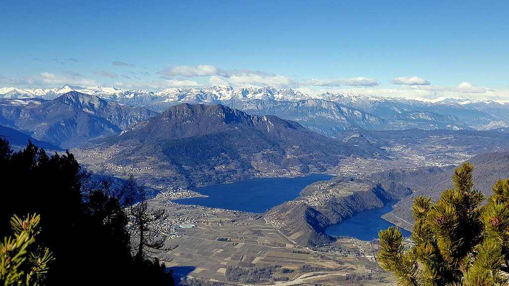
Pizzo di Levico (Cima Vezzena) 1908 m
Pizzo di Levico 1908 m, which is also called Cima Vezzena, is a mountain located in the Altopiano di Asiago, Prealpi Venete e Trentine. It is an extremely panoramic mountain, offering exceptional views towards North over the Valsugana with its scenic lakes of Caldonazzo and Levico and further North of the Valsugana towards the mountains belonging to the Lagorai Group also know as Lagorai-Cima d'Asta Group. Towards South the eye dominates much of the Asiago plateau, as well as the Lavarone and Folgaria plateaus; to the SW the small groups of the Vigolana and Marzola, that separates the town of Trento from the lakes of Caldonazzo and Levico. Towards the West and the NW the view is even more satisfying, to the Adamello group with the Carè Alto and the splendid rocky peaks of the Brenta Dolomites.
Pizzo di Levico 1908 m (chiamato anche Cima Vezzena) è una montagna situata nell'Altopiano di Asiago, Prealpi Venete e Trentine. È una montagna estremamente panoramica, che offre vedute eccezionali verso nord sulla Valsugana con i suoi pittoreschi laghi di Caldonazzo e Levico e più a nord della Valsugana verso le montagne appartenenti al Gruppo dei Lagorai noto anche come Gruppo Lagorai-Cima d'Asta. Verso Sud l'occhio domina gran parte dell'altopiano di Asiago, degli altipiani di Lavarone e Folgaria; verso SW i piccoli gruppi della Vigolana e della Marzola, che separano la città di Trento dai laghi di Caldonazzo e Levico. Verso Ovest e NW la vista è ancora più stupefacente, verso il gruppo dell'Adamello con il Carè Alto e le splendide vette rocciose delle Dolomiti di Brenta.
Getting There
•By car from Trento: exit the Motorway A22 del Brennero at the Trento Centro escape, then follow the signpost to Padova-Venezia and to take SS 47 Valsugana road. Continue on SS 47 until the escape for Altipiani di Folgaria and Lavarone. Then follow the indications for Monterovere here. Joints shortly to the locality "la Vedova" (Restaurant and horse-center) the road shrinks and knows them steeply. Joints in Monterovere locality we take on the left in direction Passo Vezzena, than it catches up (bar-restaurant-hotel and parking fastly). For the street distance Levico/Santa Giuliana-Passo Vezzena see the distance proposed from ViaMichelin for the feature Levico-Passo Vezzena. If you have a GPS navigator set up as arrival point Passo Vezzena or Passo di Vezzena.
•By car from Bassano del Grappa: from Bassano del Grappa to Passo Vezzena it convene to follow the route advised from ViaMichelin through the Altipiano di Asiago (called also Altipiano dei Sette Comuni). On navigators GPS set up as arrival point Passo Vezzena or Passo di Vezzena.
•By train from Trento: to come down to the Caldonazzo station of the railway line Trento-Venezia. For the railway timetables to see the situated one of italian national railroad service Trenitalia-italiano (or Trenitalia-english) and for the net of local connections on rubber to see the situated one TrentinoTrasporti.
•By train from Bassano del Grappa: this access is recommended for who is approached from Venice, Padova, Treviso and from the east-Valle Padana. For the timetables of the railroad see over.
Route to the summit
Pizzo di Levico from Passo Vezzena
Summit quote: 1908 m
Difficulty: E
Difference in level: 500 m
Starting point: Passo Vezzena
The path offers a pleasant and rewarding walk. It starts from Passo Vezzena 1402 m, located on the road that connects Lavarone and Luserna with the Asiago plateau. From the top the view is superb, embracing in particular the high Valsugana, the Lagorai and the plateau of Vezzena, the Adamello and Brenta Dolomites.
In the vicinity of Passo Vezzena 1402 m it begins an asphalted road (closed to the cars, it's reserved to the workers of the numerous mountain barns of the zone). Park the car in a parking lot near the Hotel Vezzena or the Baita Verle and continue on foot, following the signposts to "Forte Verle" and "Cima Vezzena". After about 500 meters leave the paved road to follow the path that runs alongside it across the meadows. The trail passes near the fine former Austro-Hungarian fortress of Busa Verle.
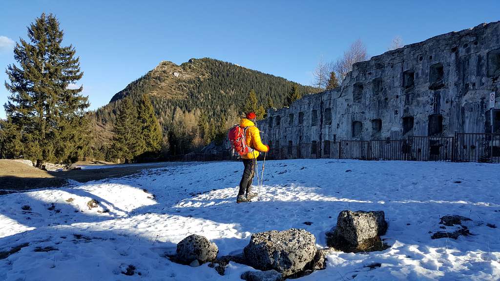
Continue along the path which runs alongside the road on the right through the meadows, you reach the thick fir woods surrounding Cima Vezzena. Here it begins the steep part of the climb. Near a saddle it starts the path SAT 205 to the the summit of Pizzo Levico-Cima Vezzena. Follow on the left the white and red marks of the SAT (=Alpine Club of Trentino) marking the path which at first is wide and winds steeply inside the shadow of the firs forest. The path becomes narrow coming out into the open on a hill among dwarf pines near the summit crest in order to catch up the top of the Pizzo di Levico. At an altitude of about 1850, this path converges on the Austro-Hungarian military road - a dirt road - which rises towards the top. Follow this road getting the fine Fortress of Cima Vezzena (1h 15' from the Forte di Busa Verle). The rests of this fortification of summit get confused with the cliffs of the Pizzo di Levico (called also Cima Vezzena, m 1908). On the summit it is placed a metallic cross with the summit book. This is the more direct route, but also that steepest one. From the beginning of the path 205, on the other hand, People who prefer to climb to the summit along a simpler and less tiring itinerary can choose another route. From the beginning of the path 205, instead of turning left on this path, it's possible to follow the first stretch of the paved road, which further on bends to the left, ignoring the forest road which branches off to the right. Shortly thereafter the paved road turns to right. Near this bend, on the left it begins the old military road that reaches the summit of Pizzo di Levico (signpost). Here therefore you need to leave the asphalt road and take this dirt road which gains slowly altitude, leading to the fortress, then to the summit. From here it may be enjoyed a wide panorama on the surrounding mountains with a breathtaking view on the lakes of Caldonazzo and Levico. The top the Pizzo stays directly over the Valsugana valley and a simple carelessness can be revealed fatal: pay attention! The return can happen along the same itinerary or coming down directly following the marks white and red of path SAT that cuts the military road many times. In winter the proposed route can be carried out with the "ciaspole" (=snow raquets), however the absence of whichever shelter or point of support of it limits the distance to the expert hikers.
Italian version: si parte a piedi dal Passo Vezzena (mt. 1404).
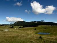 View from south
In prossimità dell'albergo inizia la strada asfaltata (chiusa al traffico veicolare) che porta alle numerose malghe della zona. Proseguire perciò a piedi. Dopo 600 metri si raggiunge il Forte di Busa Verle. Continuando lungo il sentiero che costeggia la strada a destra attraverso i prati, si raggiunge il fitto bosco di abeti che circonda Cima Vezzena. Qui inizia la parte ripida della salita. Vicino a una sella inizia il sentiero SAT 205 fino alla cima del Pizzo Levico-Cima Vezzena. Seguite a sinistra i segni SAT bianchi e rossi che marcano il sentiero, dapprima ampio e a tornanti all'interno dell'ombrosa foresta di abeti. In seguito il sentiero si restringe uscendo allo scoperto su una collina tra i pini mughi vicino alla cresta sommitale per raggiungere la cima del Pizzo di Levico. Ad un'altitudine di circa 1850, questo sentiero converge sulla strada militare austro-ungarica - una strada sterrata - che sale verso la cima. Seguire questa strada raggiungendo il forte di Cima Vezzena (1h 15 'dal Forte di Busa Verle). I resti di questa fortificazione di cima si confondono con le rocce del Pizzo di Levico (detto anche Cima Vezzena, m 1908). Sulla cima è posta una croce metallica con il libro di vetta. Questo è il percorso più diretto, ma anche quello più ripido. Gli escursionisti che preferiscono salire in vetta lungo un itinerario più semplice e meno faticoso possono scegliere un altro itinerario. Dall'inizio del sentiero 205, invece di svoltare a sinistra su questo sentiero, è possibile seguire il primo tratto della strada asfaltata, che più avanti piega a sinistra, ignorando la strada forestale che si dirama a destra. Poco dopo la strada asfaltata svolta a destra. In prossimità di questa curva, sulla sinistra inizia la vecchia strada militare che raggiunge la cima del Pizzo di Levico (cartelli). Qui quindi occorre lasciare la strada asfaltata e prendere questa strada sterrata che guadagna lentamente altitudine, salendo alla fortezza e alla cima. Da qui si può godere un ampio panorama sulle montagne circostanti con una vista mozzafiato sui laghi di Caldonazzo e Levico. La cima del Pizzo domina a picco la Valsugana e una semplice disattenzione può rivelarsi fatale: attenzione! Il ritorno può avvenire lungo lo stesso itinerario o più direttamente seguendo i segni bianchi e rossi del sentiero SAT che taglia più volte la strada militare. In inverno il percorso proposto può essere effettuato le "ciaspole", tuttavia l'assenza di qualsiasi riparo o punto di appoggio ne consiglia il percorso agli escursionisti esperti.
The fortress of Pizzo di Levico
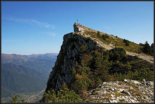
The fort of Pizzo di Levico (in German Werk Spitz Verle) for its strategic position was called to the time of the first world war "the eye of plateaus". It was in fact an strong-observatory of the austro-hungarian artillery. It controlled the depositor south towards Asiago and the depositor north of the Valsugana valley until the brace of the forts of Tenna and of Col delle Benne (close to Levico) that they made part of the defensive system of the city of Trento. Situated on the edge of a precipice, it was constructed from 1907 to 1915 and came armed with light artillery and machine-guns for the own defense. It was connected by telephone with the Monterovere locality, center of the Military Commando of Austro-hungarian zone. Since the first days of war it was subject to intense strafings from part of the italian army. Acquired from the community of Levico in 1933, currently it covers remarkable interest above all for its dared position and the panorama that is enjoyed from its top. On the roof of the fort, that it coincides with the top of the Pizzo di Levico, in the years fifty the SAT of Levico (alpin club of Levico) has placed one great metallic cross, very visible from the Valsugana valley. The fort is one construction in concrete and originally disposed reinforced concrete on three plans, equipped of underground caverns and watertight cells in order to conserve ammunitions. It was encircled from a ditch gained in the cliff that designed a horse iron and was deep approximately 5 m. and wide until 8 m.. It had an inserted trapezial plant in an artificial cliff throat protect from tightened bands of reticulates to you. Armament: 1 gun from 80 milimeter M.9 and 5 machine-guns. The main war operation was the Battle of Asiago (in english) or Battaglia degli Altipiani (in italian).
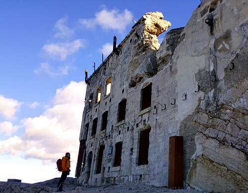
Il forte di Pizzo di Levico (in tedesco Werk Spitz Verle) per la sua posizione strategica fu chiamato al tempo della Prima Guerra Mondiale "l'occhio degli altipiani". Era in effetti un forte osservatorio dell'artiglieria austro-ungarica. Controllava il territorio a sud verso Asiago e il territorio a nord della Valsugana fino alla coppia dei forti di Tenna e del Col delle Benne (vicino a Levico) che fecero parte del sistema difensivo della città di Trento. Situato sul bordo di un precipizio, fu costruito dal 1907 al 1915 e venne armato di artiglieria leggera e mitragliatrici per la propria difesa. Era collegato per telefono con la località di Monterovere, centro del comando militare austro-ungarico. Fin dai primi giorni di guerra fu soggetto a intensi bombardamenti da parte dell'esercito italiano. Acquistato dalla comunità di Levico nel 1933, attualmente riveste un notevole interesse soprattutto per la sua posizione impressionante e il panorama che si gode dalla sua vetta. Negli anni Cinquanta la SAT di Levico pose una grande croce metallica, ben visibile dalla Valsugana, sul tetto del forte, che coincide con la cima del Pizzo di Levico. Il forte è una costruzione in calcestruzzo e cemento armato originariamente disposto su tre piani, dotato di caverne sotterranee e celle stagne per conservare le munizioni. Era circondato da un fossato scavato nella roccia che disegnava un ferro di cavallo ed era profondo circa 5 m. e largo fino a 8 m . Aveva una pianta trapezoidale inserita in una gola artificiale protetta da bande strette di reticolati. Armamento: 1 fucile da 80 millimetri M.9 e 5 mitragliatrici. La principale operazione bellica fu la Battaglia di Asiago o Battaglia degli Altipiani.
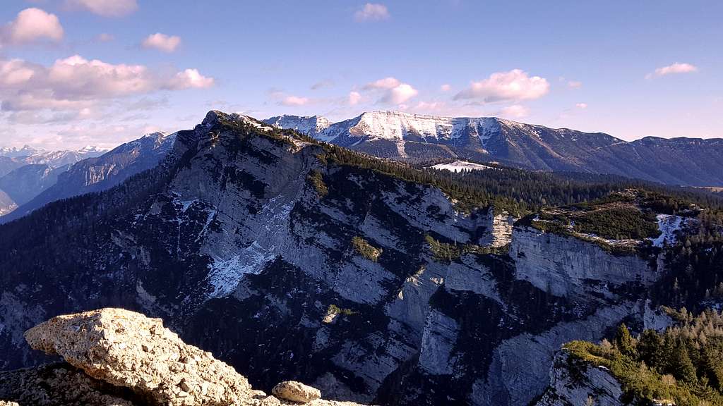
Summit panorama
 north-west summit panorama
NW from left to right (with inner links to SP): •Vigolana • Bondone •Carè Alto •Adamello •Marzola •Cima Tosa •Cima Brenta •Paganella •Calisio • Cime di Vigo
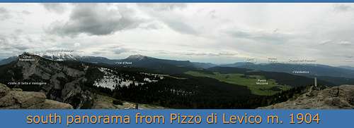 south summit panorama
S from left to right (with inner links to SP): Cima Manderiolo •Altopiano di Asiago •Spitz Tonezza •Passo Vezzena •Monte Toraro •Gruppo del Pasubio
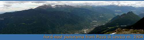 north-east summit panorama
N-E from left to right (with inner links to SP): •Gronlait and Fravort •Monte Cola •Lagorai •Cima d'Asta •Cimon Rava •Monte Tauro •Pale di San Martino •Armentera
Red tape
The asphalted narrow lane that from Passo Vezzena goes to the North in direction of the Pizzo di Levico is closed to the private traffic and it's open only as road of service for people working to mountain barns of the zone.
Hiking and scrambling scale
T - Turistico (Tourist): Itineraries on wide, clear and well worn paths, sometimes on mule tracks or gravel roads. The routes are never exposed, don't give any orientation problems and don't exceed 2500 meters of altitude. Suitable also for children.
E - Escursionisti (Hikers): Itineraries on marked trails, even narrow and with possible steep and impervious sections. They are never exposed and don't give any orientation problems. They can tread different kinds of ground, such as forests, gravel, meadows, pastures, easy rocks, etc.). They form the majority of the trails that wind up in the mountains and require a certain habit to walk; you need equipment suitable for the altitude and resistant footwear with soles suitable for rough terrain.
EE - Escursionisti Esperti (Experienced Hikers): Itineraries for hikers with experience and good knowledge of the mountain. Some of these paths may have exposed sections, however brief, which require firm foot and no dizziness. They require the ability to adapt to particular terrain, such as steep grassy slopes or stretches of rocks with difficulties that can reach the 1st degree of the UIAA scale. They can also reach high altitudes (3000 m or more). Sometimes they may include unmarked sections, requiring a good sense of orientation. Snow slopes are possible, however which can be overcome without specific mountaineering gear (rope, harness, crampons, ice-axe).
EEA - Escursionisti Esperti con Attrezzatura (Experienced Hikers with equipment - The same as EE, in addition these routes require the use of via ferrata equipment (lanyards, harness, carabiners, heat sink, helmet). This kind of itineraries range from the trails with short easy and not much exposed sections, previously equipped with fixed ropes and iron pegs, to the true and more difficult Via Ferratas climbing on rocky walls or on aerial ridges and ledges, previously equipped with long stretches of iron ropes, iron steps, ladders without which proceeding would constitute a real climbing. It is necessary to know how to use the technical equipment and have a certain habit of exposure and mountaineering terrains.
When to climb
All year round
Accomodation
Valsugana with the town of Caldonazzo and Levico is a primary destination.
Meteo Forecast
Bibliography
•Advised cartography: Kompass 631 (Altipiani di Folgaria, Lavarone e Luserna) 1:25.000
•Books: for news wide and deepened on the course of the forehead and the military operations in the zone is indispensable to refer to the historical work of Walther Schaumann: "La grande guerra 1915-18, Volume 3 - Prealpi Venete e Trentine", Ghedina & Tassotti Publisher Limited, Bassano del Grappa (Italia), 1984 (this is the italian version of the original “Schauplaetze des 3 Gebirgskrieges - Oestliche Dolomiten, Sexten, Cortina di Ampezzo”. Colonel W. Schaumann also has founded the association Friends of the Dolomiti that has cured the risistemazione of trenches and distances of war. •History: numerous historical references to the war operations of the first world war are available into the multimedia encyclopedia Wikipedia. We have chosen this only external link one because the reperibile material in the WEB is truly too much wide. The various national versions of Wikipedia concur to form a picture of the facts to my opinion enough objective. See the the italian, english and german version. •local tourist office •local mountain meteo
External Links