
-
 17459 Hits
-
 82.96% Score
-
 16 Votes
|
|
Mountain/Rock |
|---|---|
|
|
41.32988°S / 72.61827°W |
|
|
Hiking, Mountaineering, Scrambling |
|
|
Spring, Summer, Fall, Winter |
|
|
6572 ft / 2003 m |
|
|
Overview
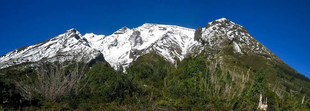
Located in the southern end of an area known as the Lake District in south-central Chile, Calbuco Volcano is a dormant stratovolcano with many different summits surrounding a massive crater. It sits in the middle of Region de Los Lagos among many other volcanoes and spectacular mountains. The eruptive history is actually quite long and has had at least 9 eruptions since 1837, with the latest one being a small, 4 hour plume eruption in 1972. One of the largest historical eruptions in southern Chile originated from Calbuco in 1893–1894. Volcanic bombs were ejected to distances of 8 kilometers from the crater and was accompanied by large lahar flows that reached Lago Llanquihue. Strong explosions occurred in April 1917, January 1929, and in 1961. Although this mountain appears to be extinct due to its non-conical shape, but an active monster dwells beneath it.
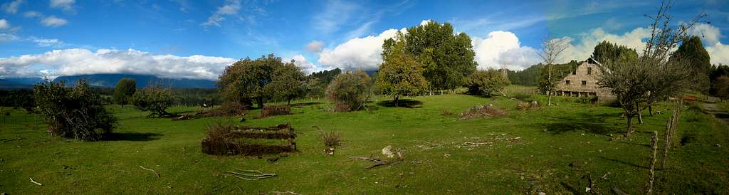
Just across the lake is Osorno Volcano which has a perfect cone shape and is home to an excellent ski club. Views of Osorno, and the lake with the surrounding peaks that span the Chile/Argentina border are breathtaking. If you are in the area, this is a hike that is not to be missed. There are two established ways to reach the summit. The standard route goes up the trail on the south side but a more obscure route that starts from the Casa Ko B&B ascends the north side. Both are beautiful routes but the route on the north side really gives you an excellent perspective on the country of Chile. Passing through beautiful meadows, exotic forests and incredible scenery, I highly recommend the route on the north side. Permission is typically required for this route though.
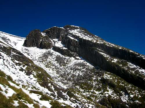
 Calbuco Volcano after a fresh fall snow
Getting There - South Side Standard
For the standard south side route on Calbuco, you will need to rent a car or hire a taxi because no buses go to the trailhead for this route. Once you arrive at the bus depot in Puerto Montt, make your way through town to the coast and head east along the shore through the market. There is always traffic in this part of town so plan ahead. You will need to continue along the shore on Av. General Juan Soler Manfredinni (Also National Highway 7) and around to the next small town. Here you will drive by a huge sandy beach, cross a small stream and continue over a hill to the large Rio Chamiza. Just before the highway crosses the river, turn left (north) into Road V-65 and follow this paved road as it veers eastward, crosses a smaller stream (Rio Chico) and follows the broad valley. 20 kilometers from Highway 7, turn left onto a gravel road heading north towards the large fishing operation (I think it's fishing) and park at the large parking area just after the road crosses a stream over a sketchy bridge. Do not enter the operation. Best to have the LLanquihue Travel & Trekking Map (2010) 1:150,000 in hand to aid in the drive there. See the map below for details about how to get through Puerto Montt. Of course, if you hire a taxi you can just tell the driver you want to go to the start of the Los Alerces del Rio Blanco trek and he will probably know where to go.
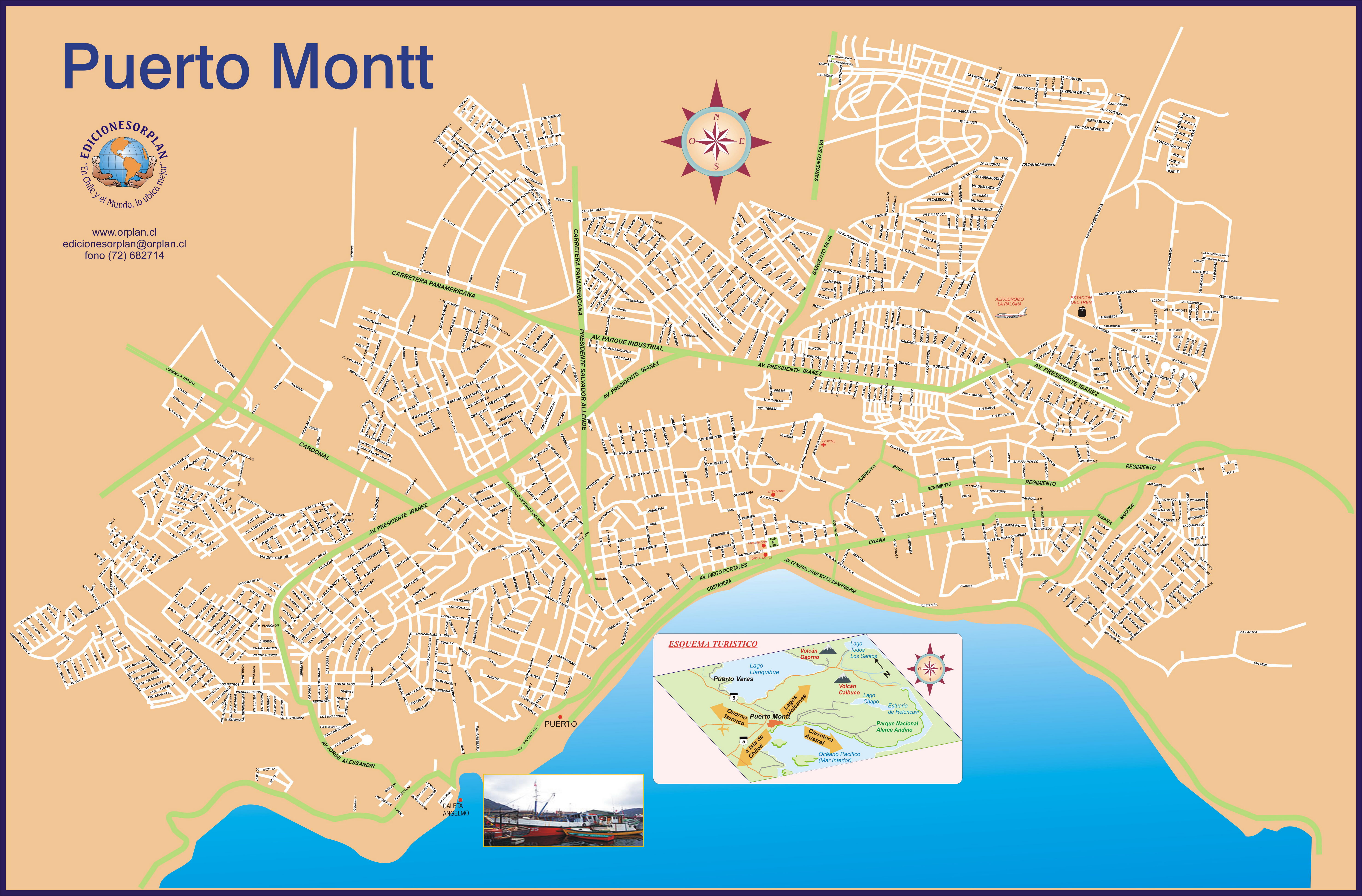 Road map of the city of Puerto Montt - Click to Enlarge
Getting There - Casa Ko B&B North Side Alternative
Puerto Montt is the nearest major city and is a large port town at the head of the Golfo de Ancud. This area is also known as "Where the Islands Start" and marks the extreme northern boundary of Patagonia. LAN airlines have flights that regularly depart from Santiago to Puerto Montt for a very reasonable price. LAN is also an excellent airline. From the Puerto Montt airport, a shuttle bus takes passengers to the main bus depot in downtown Puerto Montt every 15-20 minutes or so and costs roughly 2,000 Chilean Pesos ($4). From the bus depot, you want to get to the small german settlement of Puerto Veras. This tourist town is a spectacular place located on the southern corner of the very large Lago Llanquihue and on a sunny day, both Osorno and Calbuco are easily seen from the small beach in town.
The best way to get to Puerto Veras is to take one of the smaller blue collectivo buses that leave all the time from the bus depot in Puerto Montt. It's about a 20 minute ride north to Puerto Veras. Once here, you can easily walk around town and find many places to eat quality food, exchange money etc. There are 2 small climbing shops in town, owned by the same family and they also offer rental cars (limited supply) for $50 per day. I found this much easier than trying to find a rental place in Puerto Montt. These climbing shops also have canister fuel, some rock climbing gear, a good selection of clothing, excellent maps of the area, and they offer organized activities such as rafting, climbing, hiking, mountain biking and mountaineering, none of which is cheap. There is also a third place that rents cars just a block from the lake called Hunter Rent a Car and they were also great. It's suprisingly easy to rent a car and get around like one would in the US. The roads are generally in great shape and good road maps are easy to come by such as at the tourist information booth right along the lake shore across the street from Cassi's Resturant (highly recommended).
From Puerto Veras, getting to Calbuco is very easy. If you rented a car, drive about 40 kilometers east along National Highway 225 the south shore of the lake. This is a beautiful drive. You can also take a collectivio (with signs for Ensenada) for a couple bucks. Just tell the driver you want to get off at Casa Ko and he will let you know when to get off. Just before reaching the small town of Ensenada, locate a gravel road heading south with a sign for the Casa Ko Bed and Breakfast. If you took a bus, you will have to walk about a mile up this road to the B&B which is run by a lovely French couple from October through April. Either stay here (cheapest room is $45/person/night but much cheaper if you are travelling with another person, and includes breakfast) or continue up the gravel road passing a few more houses and weaving through farms and grazing meadows. See the north side route description below for information about the route. For more detailed information on getting to Casa Ko, see this link - Directions
See this link for more information about the services and costs offered at Casa Ko. It really is a lovely place and they even have a place to park a rental car if you have one and they will also hold on to extra gear you have and may not want to lug everywhere if you don't need it. See the map below for an overview of the area. Lago Llanquihue is the round lake just north of Puerto Montt and Calbuco is in the Reserva Nacional Llanquihue ENE of the city just south of Ensenada. Click to enlarge.
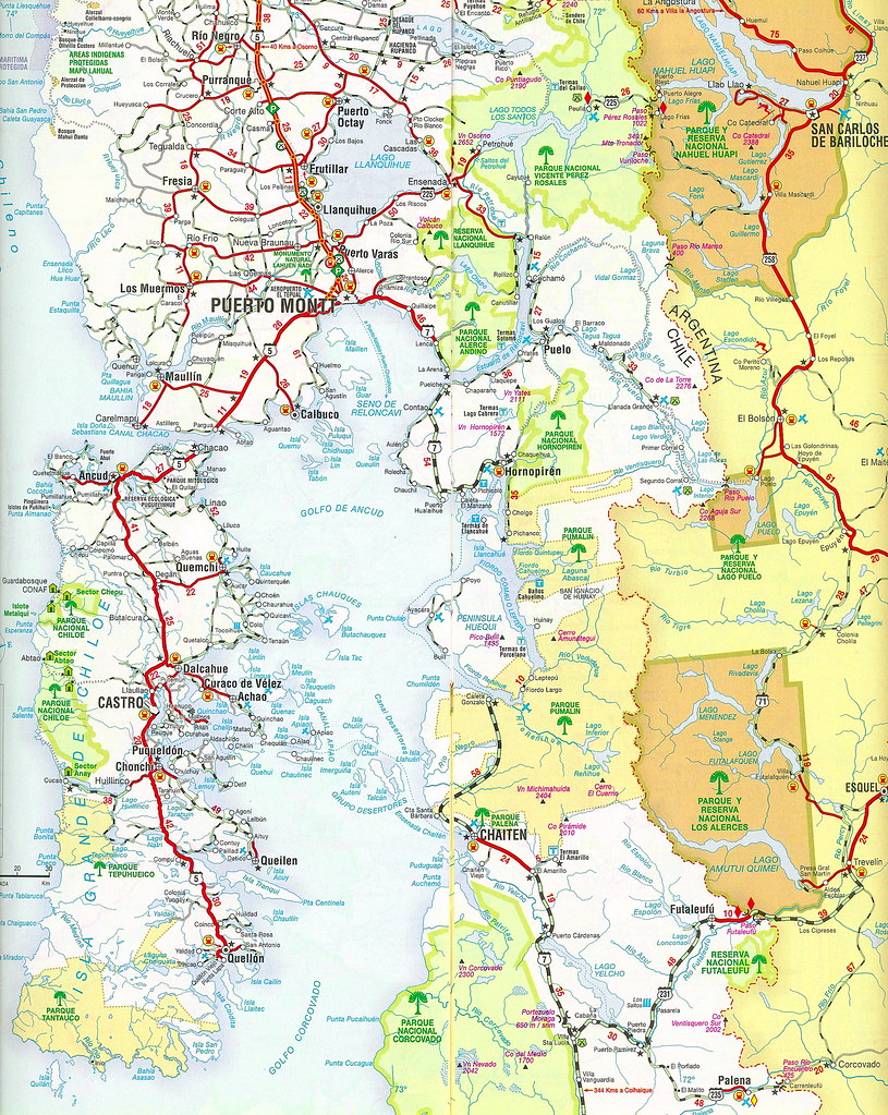 Region de Los Lagos Road Map
Route Options
South Route Standard - Class 2
From the parking area described above, locate the trail as it winds through the trees around the fishing operation and begins climbing steeply up some stairs, enters the National Preserve and reaches an open meadow with the ranger cabins after 15 minutes or so. You will probably have to sign in with the rangers, who will only speak Spanish. Continue up the trail which is very easy to follow to treeline then follow the ridge of the crater rim to the high point. I have not done this route myself but have heard it is very straightforward, albeit long.
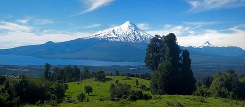
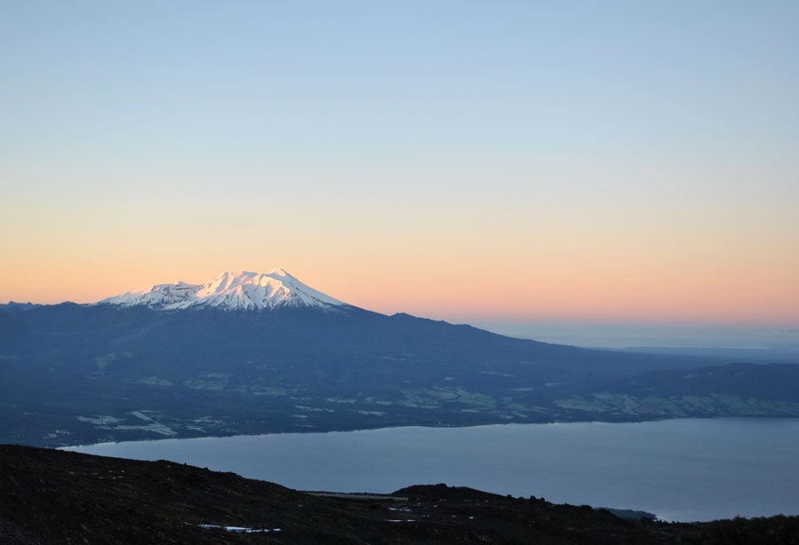
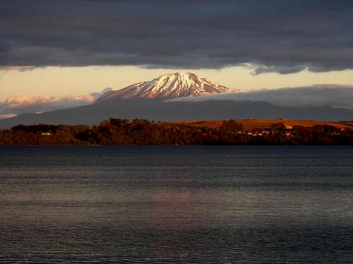 Volcan Calbuco from Lago Llanquihue
North Side Route - Class 3
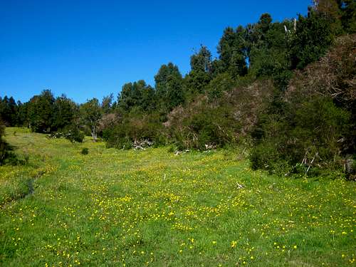
For this route, start at the Caso Ko B&B (elevation 180 meters) and speak with the couple there about the route information and look at their image maps (shown below as well). They may want to go with you as a guide but if you let them know you are experienced climbers you should be fine. Continue up the gravel road passing various other homes and chalet style buildings and crossing through many texas gates. The road will cross a small stream and just under a mile from Casa Ko, reach the end of the road at a small meadow farm with a couple small buildings and a very large amount of stacked firewood. Continue along the now hiking trail and pass by the first of 3 small ponds at 280 meters. Emerge into a very large series of open grassy meadows and pass by a second pond at 350 meters elevation.
 View south from Casa Ko B&B
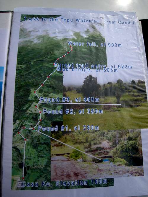 Calbuco Map 1 Calbuco Map 1 |
 Calbuco Map 2 Calbuco Map 2 |
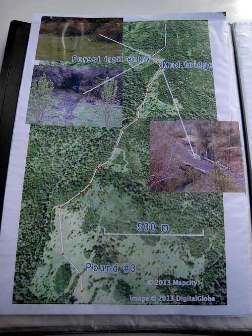
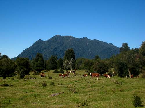
From here the route through the maze of meadows can be tricky. You must continue south through the meadows (which will be full of cows), pass the third pond at 400 meters elevation and walk through another gate. Then veer slightly left and hike SSE to the southern most corner of the large meadow. Here you will find a trail through the trees that initially turns right and heads west a few minutes, then steepens and becomes very muddy for about 100 feet, then mellows and continues past another smaller meadow which is to your right (west) before emerging into another large meadow but narrow, N-S oriented meadow. It's 500 feet of gain from the southern end of the previous meadow system to the start of the long meadow here. Cross another gate and continue SSW following the line of trees on the east side. Once you reach the southern end of this meadow, locate the short mud bridge and veer left to cross it. Once across it you will come to the final meadow which makes a great place to camp if you want to make the climb an overnighter. This final meadow is small, oriented NW-SE and at an elevation of 2000 feet (605 meters). Hike SE up this meadow along a tiny stream for 5 minutes or so and locate the trail heading into the dense forest to the right. Locating this trail is imperative and is marked by a couple small trees and looks like a port-hole into an otherwise impassible forest. See photo at right below.
 Hiking through the Meadows Hiking through the Meadows |
 Final meadow Final meadow |
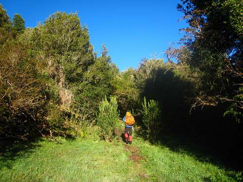 Trail entrance Trail entrance |
 Osorno from the meadows on the north side of Calbuco
Follow this trail through the forest as it slowly emerges into a more alpine environment. The trees slowly dwindle and your first views of Calbuco up close are seen. You will emerge onto a ridge with a very steep drop to the left. A large and deep valley divides the north face of the mountain and you will come to a huge waterfall visible in the valley. From here the route becomes much more visible. You will pass by a cow skull and Richard at the Kasa Ko will have told you to turn left here and descend steeply (and dangerously) down into the valley, cross the stream and climb out to the ridge on the east side. This just adds time and difficulty to the route. Look straight up the ridge you are on and follow it up. It's an easy grassy hike for awhile, then transitions into loose rock. Pass by a narrow spot on the ridge where the rock is scary loose with exposure. Continue up the now broad ridge on talus for 2500 feet or so until you reach a small cliff band. Carefully scramble up this (Class 3) and emerge onto the summit crater area. The highest point can be tricky to locate but it is on the west side of the crater. Scrambling around the broad crater rim should never exceed Class 2 but use caution as the rock is very loose and ice can linger well into the summer. This climb is about 16 miles RT and gains 1,900 meters. Plan for a very long day or 2 day climb.
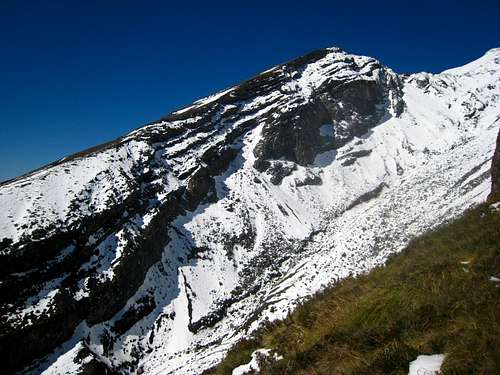 Looking across the valley on the ridge up Calbuco Looking across the valley on the ridge up Calbuco |
 False summit of Calbuco taken from the ridge False summit of Calbuco taken from the ridge |
 Beautiful light on Calbuco seen from the ski club on Osorno
Camping/Red Tape
There is no red tape to climb this mountain as far as fees are concerned. However, if you are climbing the southern route you will need to sign in with the rangers and they can sometimes close the trail during bad weather. On the north side of the mountain, permission from Richard and Priscilla is required. Great camping is found in the final meadow on the north side route. On the south side route, excellent camping can be found at the refugio.When to Climb
The best time to climb is From October through April. Remember, the seasons are opposite in southern Chile than they are in North America. Snow will typically linger on the mountain through January and by April, the first fall storms begin to dump snow high on the mountain. Think North Cascades as far as the climate is concerned.
gimpilator - Apr 24, 2015 8:39 pm - Hasn't voted
Current EruptionHave you heard about this?
Matt Lemke - Apr 24, 2015 8:58 pm - Hasn't voted
Re: Current EruptionYes I have... It's awesome!