
-
 8648 Hits
-
 87.31% Score
-
 24 Votes
|
|
Mountain/Rock |
|---|---|
|
|
68.17830°N / 14.22480°E |
|
|
Nordland |
|
|
Hiking, Scrambling |
|
|
Summer |
|
|
1775 ft / 541 m |
|
|
Overview
Geographical classification: The Scandes > Lofoten Islands > Festvågtinden
Festvågtinden m 541
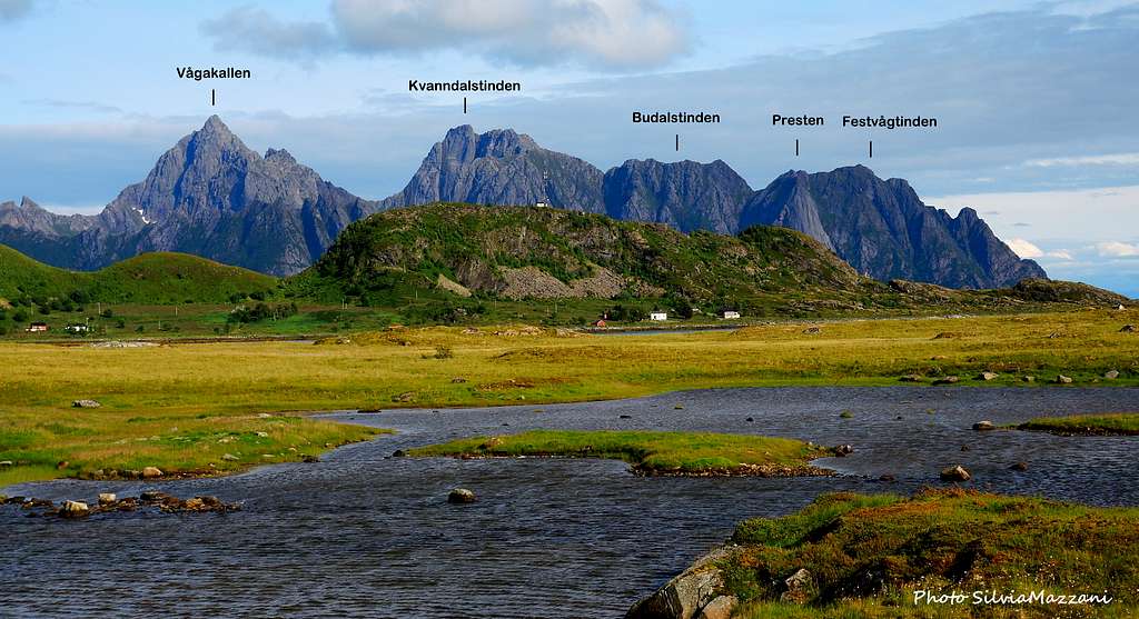
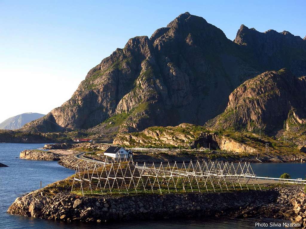
The Lofoten archipelago lies off Norway's Northern coast, West to Narvik and 200 km North of the Artic Circle. It is shaped in five large and five smaller islands. The isle of Austvågøy counts a good number of interesting peaks for summiting. Many of these, located in the North of the island, are quite remote to approach, but we can find other fine ones close to Svolvær and Henningsvær, accessible by short scrambles and featuring incredible views over the magnificent seascape, the islands and the surrounding ranges. Festvågtinden is one of these peaks, located on the Southern side of Austvågøy and closely dominating Henningsvær, the Venice of Lofoten, a village lyng in a superb setting made of stunning peaks and surrounded by the sea.
Notwithstanding its tremendous look, Festvågtinden is a walking peak and its standard route doesn’t involves any rock climbing or scrambling, as a matter of fact it's wrapping around the peak and getting rather easily to the summit, from which it's possible enjoy great views over the village and the surrounding cliffs. For this reason the ascent is advisable when the weather is clear.
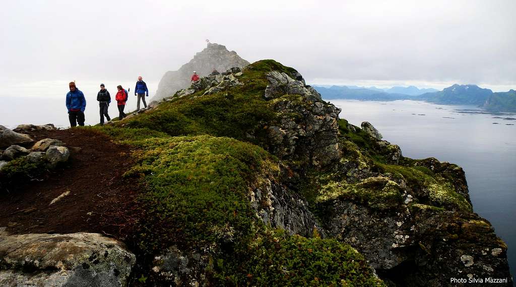
The trail rises very steeply, but the ascent is done by walking and the only rocky moves - quite easy and not exposed - are encountered on the last meters along the summit block. Be aware that after rainy periods the route can be a bit muddy, anyhow without real difficulty. The itinerary reaches quickly a notch along the summit ridge, where it appear a breathtaking view across the sea on the other side of the crest. From the notch the summit ridge leads in a few minutes to the summit signal.
Getting There
Getting to Lofoten
There are various possibilities:
- By ferry boat from Skutvik to Svolvær
- By car from Evenes Airport to Svolvær
- By plane from Bodø
- By ferry boat from Bodø to Moskenes, Værøy or Røst (Southern Lofoten)
The closest town to Festvågtinden is Henningsvær.

Road approach to Festvågtinden
It's possible to get to the cliff directly from Svolvær, Lofoten major center, in about 20 km along E10 road and also from Kabelvåg, in about 15 km. along E10, turning to left to Henningsvær (Road 816) at E10 and Road 816 junction. Otherwise the shortest way to approach the cliff is from Henningsvær or from Lyngvær (less then 5 km), a good place along E10, about 20 km. West to Svolvær.


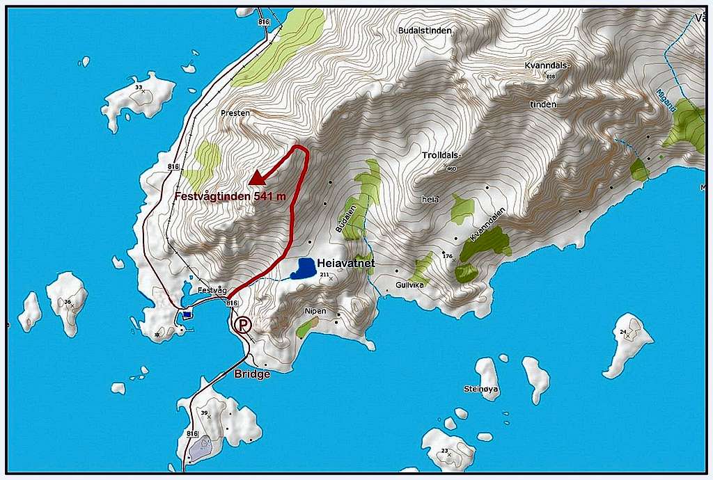
From anywhere you are coming, once you are on the road 816 to Henningsvær follow this latter until the first big bridge that leads to the town. Just before the big bridge you will find a small pull out on the right. Park the car here and go back a few hundred meters along the road just traveled to take on the right a well worn path amongst the vegetation. This is the starting point of the ascent.
Festvågtinden Normal Route report

Festvågtinden Standard route
Summit altitude: m. 541
Difficulty: Easy scramble
Vertical gain: 541 m
Exposure: East
Starting point: Road 816 close to Henningsvær first bridge
It's an easy and fun half-day walk up a scenic slope facing East, providing stunning views over the surrounding peaks, Henningsvær islands, the mighty Presten and mainland in background.


Once taken the path, it passes near the foundations of an old building to cross immediately after an area of large boulders. After the boulders, the trail begins to climb steeply, reaching a fork. Take the left branch as the right one leads to a lookout and continue to climb steeply until you reach the basin where there is a small beautiful lake named Heiavatnet, which was once the ancient water reservoir of Henningsvær.


Without reaching the lake, the track veers sharply to the left in the direction of the peak to get close to the cliffs and climb at first an area of boulders and vegetation. After a bit the trail begins to head more and more to the right (North) to avoid the cliffs and the small lake begins to appear below you. The trail climbs sometimes very steeply, but it never involves rock climbing. After rainy periods the trail can be a bit muddy, but it reaches quickly a notch along the summit ridge without real difficulty. A breathtaking view appears across the sea on the other side of the crest. From the notch turn to left (South) towards the visible summit following the summit crest, getting to the last not exposed rocky step and to the summit signal.


Descent: reversing the route
Red Tape


There are no particular restrictions in climbing and hiking.
Accomodation

In Svolvær and surroundings there is a wide choice of different kinds of accommodations: hotels, campgrounds and the traditional and typical rorbuers, the Norwegian fishermen's cabins, available in Svolvær, Henningsvær, Kabelvåg. In Norway free camping is allowed in every place, if not expressly forbidden. A free campground is located along the road a few hundred meters before the parking lot, just close to Gandalf crag.
When to climb
, Festvågtinden slopes")
Best months to climb are late May, June, July and August
Midnight sun: from 27 May to 17 July
Polar night: from 6 December to 6 January
Climate
On Lofoten the weather can change suddenly from clear and blu sky with sunshine or the Northern Lights (Aurora Borealis) to violent storms with rain or snow. Maximum temperatures go from +30°C in June and July to -15°C in January and February; the average temperatures for these months are from +12°C to -3°C. The period with the minimum rainfall goes from April to June, while we may expect the maximum rainfall or snowfall between October and December.
Midnight sun: from 27 May to 17 July Polar night: from 6 December to 6 January
The Northern Lights can be seen over Lofoten from September to April.
Useful info about climate: Meteorologisk Institutt
| Month | Avg Low | Avg High | Precipitation (mm) | Wet Days | Daylight (Hours) |
| January | -2°C | 1°C | 65 | 18 | 5 |
| February | -2°C | 1°C | 60 | 17 | 10 |
| March | 0°C | 3°C | 65 | 18 | 14 |
| April | 1°C | 5°C | 55 | 17 | 20 |
| May | 5°C | 9°C | 55 | 18 | 24 |
| June | 7°C | 12°C | 70 | 18 | 24 |
| July | 9°C | 15°C | 65 | 18 | 24 |
| August | 8°C | 15°C | 90 | 20 | 22 |
| September | 7°C | 13°C | 100 | 22 | 15 |
| October | 5°C | 8°C | 110 | 23 | 10 |
| November | 3°C | 6°C | 85 | 19 | 6 |
| December | -1°C | 3°C | 75 | 19 | 2 |
Meteo
Guidebooks and maps


- "Lofoten Rock" by Chris Craggs and Thorbjørn Enevold - Rockfax
External links
Rockfax Lofoten guidebook
Lofoten Info