
-
 5201 Hits
-
 88.61% Score
-
 27 Votes
|
|
Mountain/Rock |
|---|---|
|
|
68.20380°N / 14.31120°E |
|
|
Nordland |
|
|
Hiking, Trad Climbing |
|
|
Summer |
|
|
1375 ft / 419 m |
|
|
Overview
Geographical classification: The Scandes > Lofoten Islands > Glåmtinden
Glåmtinden m 419
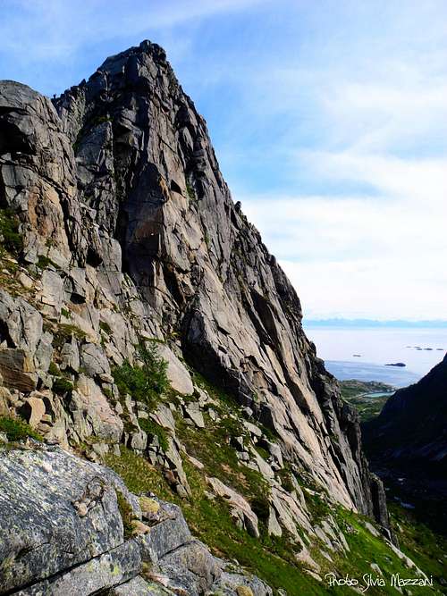
The isle of Austvågøy in the Lofoten archipelago counts a considerable number of wonderful peaks and crags to climb, located in different areas. Amongst these latters, the surroundings of Kalle offer plenty of walls and routes of great interest. A high-class destination can be reached starting from the Rorvika junction: Glåmtinden. Glåmtinden is a granite tower showing a prominent and fine summit located along a windy ridge, overlooking a greatly varied landscape, dominated by the majestic bulk of Vagakallen and lively due to the presence of three mirrors of water: the lengthened Rorvikavatnet to the West and two smaller beautiful twin lakes divided by a thin strip of land just in front of.
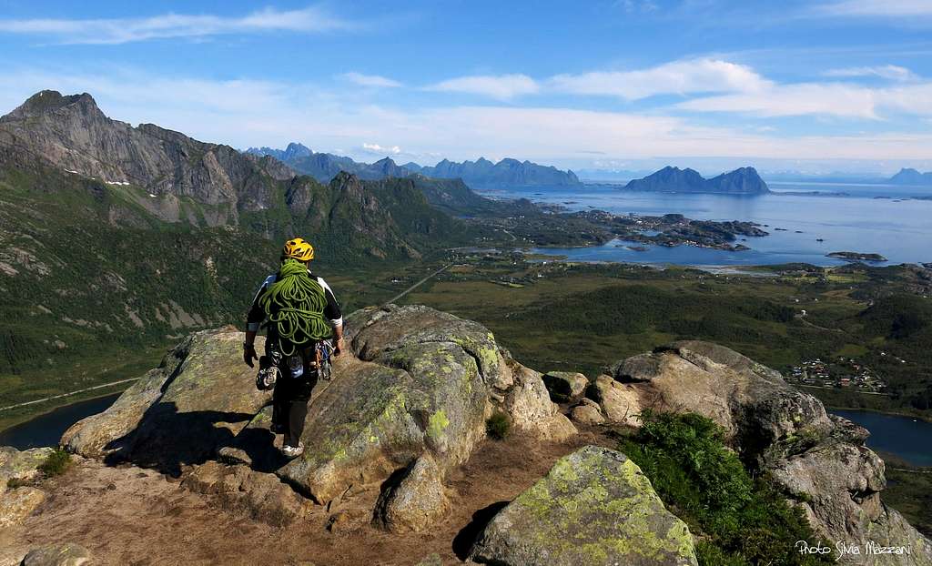
Glåmtinden is quite a popular summit both for climbers and hikers. On a clear day the views over the sea and the Lofoten peaks and beyond on the mainland are unsurpassed. A exciting climb along the SW ridge, Ørneryggen (Eagle Ridge), draws the attention of the climbers, while hikers can reach the summit of this fine peak in a couple of hours along a well worn trail.
Getting There
Getting to Lofoten
There are various possibilities:
- By ferry boat from Skutvik to Svolvær
- By car from Evenes Airport to Svolvær
- By plane from Bodø
- By ferry boat from Bodø to Moskenes, Værøy or Røst (Southern Lofoten)
The closest town to Glåmtinden is Kabelvåg.


Road approach to Glåmtinden
It's possible to get to the cliff from Kabelvåg or directly from Svolvær, Lofoten major center along E10 road, getting the Rørvika junction at E10 and Road 816 junction. Otherwise another good way to approach the peak is from Henningsvær or from Lyngvær, a good place along E10, about 20 km. West to Svolvær. Coming from Rørvika junction follow the E10 Svolvær direction (towards West), skirting the lake, and park the car at an extensive pull-out about 650 meters after the Rørvika junction. Here it starts a dirt road (the old Route 19, before the construction of the new road and the tunnel).
Ørneryggen report
Glåmtinden - Ørneryggen report (Norwegian scale)
Summit altitude: 419 m
Difficulty: 5+ (Norwegian)
Climbing length: 150 m
Exposure: SW
Equipment: trad route
First ascent: Thorbjørn Enevold, Brynjar Østgaard, Odd-Birger Hanssen 11-6-1993
Starting point: pull out East of Rørvika junction
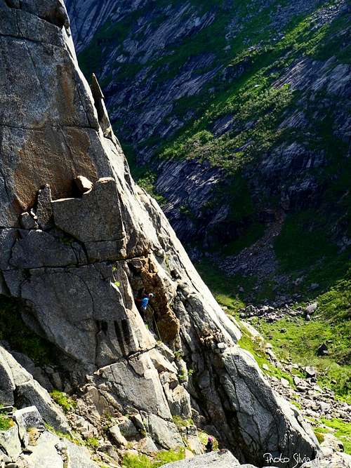
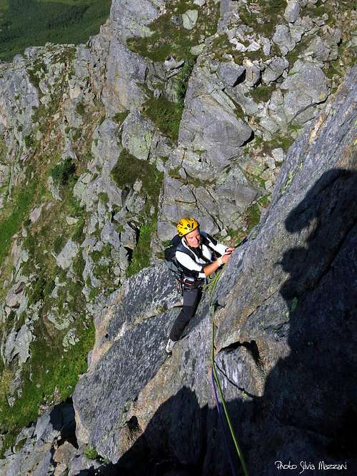
Ørneryggen (Eagle Ridge) is a classic trad route on good rock. Despite the shortness of the route, the climb is very satisfying and some pitch are truly fantastic; the pleasant atmosphere, the wonderful landscape, plus the bonus of a true summit, make this route quite advisable. The ridge remains in the shadows until the middle of the morning.
Approach - From the parking lot follow the dirt road in moderate ascent for about 1600 meters and reach a flat hill where you must leave the road and take a path on the right, going up towards the tower and getting a kind of sandy hill from which it starts the last section of the Normal route to climb the peak by walking. Here you leave the Normal route and traverse definitely to the right, following a vague trail that crosses horizontally, getting to a rocky collar from where it appear the SW ridge. Descent briefly following a vague trail that forks. Follow the right branch to reach the slanting slabs of Direkte Innsteget variant, that allows to add a pitch more to Ørneryggen respect the original start.
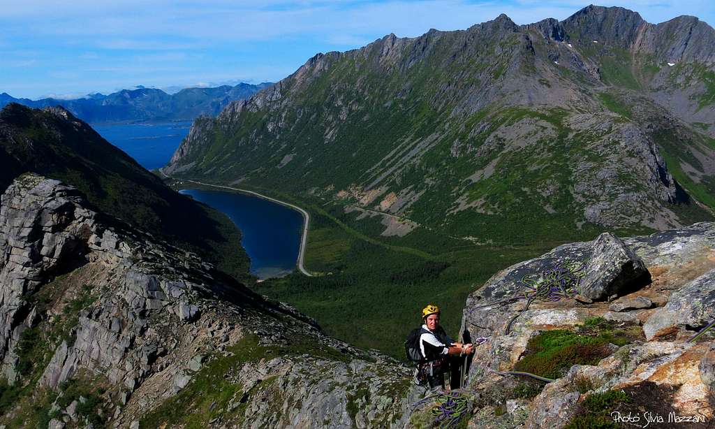
A party starting Ørneryggen |
Ørneryggen (Eagle Ridge) |
Glåmtinden SW face |
Route report
L1 - Direkte Innsteget variant. Climb the sloping slabs at first directly, then long slanting left, to take a spur that leads to a pulpit (the original attack) 4, 50 m
L2 - Up a yellow wall with good holds and a bit crumbly, then traverse left under a roof to take a groove. Up the groove and exit on the left wall beyond the edge and through another wall to the right reach a tiny stance on the edge of the ridge 5, 38 m
L3 - Slanting right to take up a large crack, then head to left, overcoming a small overhang and continue along another crack getting below an overhanging wall with good holds. Overcome the wall and belay on a comfortable ledge. 5+, 32 m
L4 - Traverse right on the ledge, get over a wall then a dihedral, around the edge on the left and exit on the fantastic summit, complete with summit-log! 4+, 30 m.


Descent: following the Normal route, a simple hike. From the summit head to North on a well worn path, reaching the flat col and the dirt road, then the parking lot
Glåmtinden Normal route
Glåmtinden Normal route
Summit altitude: 419 m
Difficulty: walk
Vertical gainl: 419 m.
An easy walk up a true summit with fantastic views
From the parking lot follow the dirt road in moderate ascent for about 1600 meters and reach a hill flat, where you leave the road and take a path on the right going up towards the tower, reaching a kind of sandy hill from which it starts the last section of the trail, leading quickly on the summit.

Red Tape
There are no particular restrictions in climbing and hiking.
Accomodation
In Svolvær and surroundings there is a wide choice of different kinds of accommodations: hotels, campgrounds and the traditional and typical rorbuers, the Norwegian fishermen's cabins, available in Svolvær, Henningsvær, Kabelvåg. In Norway free camping is allowed in every place, if not expressly forbidden.
When to climb

Best months to climb are late May, June, July and August
Midnight sun: from 27 May to 17 July
Polar night: from 6 December to 6 January
Climate
On Lofoten the weather can change suddenly from clear and blu sky with sunshine or the Northern Lights (Aurora Borealis) to violent storms with rain or snow. Maximum temperatures go from +30°C in June and July to -15°C in January and February; the average temperatures for these months are from +12°C to -3°C. The period with the minimum rainfall goes from April to June, while we may expect the maximum rainfall or snowfall between October and December.
Midnight sun: from 27 May to 17 July Polar night: from 6 December to 6 January
The Northern Lights can be seen over Lofoten from September to April.
Useful info about climate: Meteorologisk Institutt
| Month | Avg Low | Avg High | Precipitation (mm) | Wet Days | Daylight (Hours) |
| January | -2°C | 1°C | 65 | 18 | 5 |
| February | -2°C | 1°C | 60 | 17 | 10 |
| March | 0°C | 3°C | 65 | 18 | 14 |
| April | 1°C | 5°C | 55 | 17 | 20 |
| May | 5°C | 9°C | 55 | 18 | 24 |
| June | 7°C | 12°C | 70 | 18 | 24 |
| July | 9°C | 15°C | 65 | 18 | 24 |
| August | 8°C | 15°C | 90 | 20 | 22 |
| September | 7°C | 13°C | 100 | 22 | 15 |
| October | 5°C | 8°C | 110 | 23 | 10 |
| November | 3°C | 6°C | 85 | 19 | 6 |
| December | -1°C | 3°C | 75 | 19 | 2 |
Meteo

Guidebooks and maps


- "Lofoten Rock" by Chris Craggs and Thorbjørn Enevold - Rockfax
External Links
Rockfax Lofoten guidebook
Lofoten Info