
-
 21620 Hits
-
 91.45% Score
-
 35 Votes
|
|
Mountain/Rock |
|---|---|
|
|
67.98078°N / 12.98091°E |
|
|
Nordland |
|
|
Hiking, Trad Climbing |
|
|
Summer |
|
|
1975 ft / 602 m |
|
|
Overview
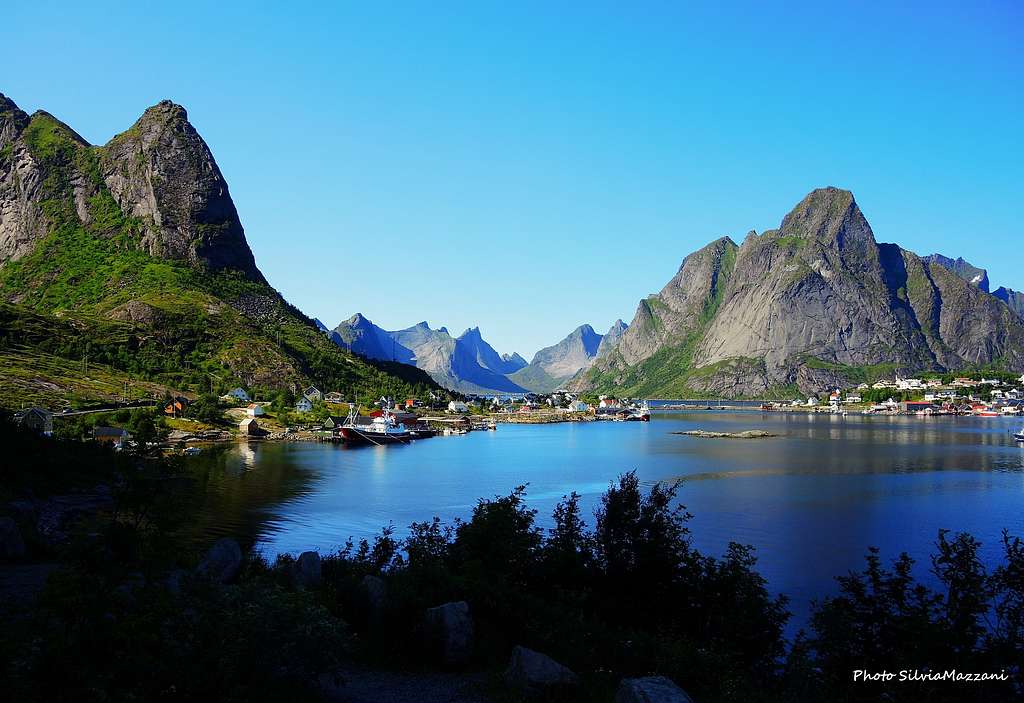
Helvetestinden 602 m
The breathtaking Lofoten Islands lie off Norway's Northern coast, West to Narvik and 200 km North of the Artic Circle. They are shaped in five large and five smaller islands and offer a wide choice of granite rock-climbing as well as winter mountaineering and summer scrambling. Helvetestinden - literally The Hell Peak - is a mighty granite peak lying on Moskenesøy Island, the Lofoten westernmost island. Its location is truly spectacular, since the Helvetestinden stunning West face, 600 meters drop, is overlooking the Norwegian Sea and the wide and white sandy beach of Bunestranda, one of the more scenic and secluded beaches on the Lofoten Islands.
")
On the awesome West face of Helvetestinden we find a few challenging trad routes only for skilled climbers. Notwithstanding the impressive steepness of this cliff, surpringly the peak can be summited easily through its standard route. Scramblers and hikers may climb the peak along the "Sor Ryggen" (South Ridge), an excellent route to reach the summit, a wonderful place to enjoy breathtaking views all around.
Getting There
GETTING TO LOFOTEN
There are various possibilities:
- By car from Evenes Airport to Svolvær
- By ferry boat from Bodø to Moskenes, Værøy or Røst (South of Lofoten)
- By ferry boat from Skutvik to Svolvær or Skrova (North of Lofoten)
- By plane from Bodø


Getting to Helvetestinden
The reference-point is the picturesque village of Reine, lying on the shore of Reinefjorden, on the island of Moskenesøy, in the South-West of Lofoten. Two different ways to get to Reine:
- by car from Svolvær, following the Kong's Olav Veg (E10), a beautiful trip across the islands in about 124 km.
- by ferry boat directly from Bodø to Moskenes (5 km. from Reine)
The approach walk to Helvetestinden is starting from the small village of Vinstad, lying at the entrance of Bunesfjorden; Vinstad is very well reached in 1 hour from Reine, sailing by ferry across the Reinefjorden and the Kierkefjorden, another wonderful trip amongst several impressive granite-peaks.


Sor Ryggen (South Ridge) Normal Route report
Sor Ryggen (Normal Route) report
Summit altitude: 602 m
Difficulty: Easy scramble
Vertical gain: 600 m from Vindstad wharf
Exposure: South
Starting point: Vindstad wharf
A very interesting and panoramic route to enjoy exciting views over the fjords and the majestic granite peaks all around Kierkefjorden and Bunesfjorden


From Vindstad ferry pier take a well worn and mainly on level path crossing the small village. Follow it along the left shore of Bunesfjorden (Western shore), in the direction of the back of the fjord. As you near this latter, you will meet a graveyard on the left. Avoid the trail towards the graveyard and carry on in the direction of the cabins at the head of the fjord. You soon will see a signpost "Bunes". Follow this good trail heading left and up the hill, leading to a pass - Einangen Col - where you can enjoy quite exciting views over the scenic Bunes beach and the majestic walls of Helvetestinden (right) and Storskiva (left) overlooking it.

From the col the main trail reach the Bunestranda (Bunes beach); to get to the Helvetestinden summit at the col leave the main trail and head to right looking for a trail - in the beginning not very obvious - crossing a grassy slope and heading towards a large rocky field.


As you near the granite slabs the trail becomes well worn and climbs a gentle sloping gully rising amongst the rocks and getting to the Brunaksla Col, where it's located the starting point of South Ridge. From the col it appears an amazing view over Kierkefjorden back with the village of Kierkfjord.

The trail turns to left and an easy scramble along the narrow and a bit exposed ridge will lead you on Helvetestinden small and airy summit. The views both to Bunestranda and the mighty peaks dominating the beach on the left and Kierkfjorden on the right are exciting and unsurpassed. On the summit it appears also a sensational view over the Norwegian sea in the North direction. You can register yourself on the Summit-Book, curiously placed inside a little cairn by a tyrolean team of climbers.
Descent: reversing the same route (3-4 hours roundtrip).
Climbing routes overview
***Helvetestinden West Face Routes (Norwegian Scale)


Different challenging trad climbing routes run on the stunning West Wall of the peak. From left to right:
“Left Approximation” 6-, 600 m
“Helvetesveggen” 5+, A1 500 m
“The Next Best Thing” 6+, 300 m
“Norwegian Sheep Ranch” 7, 300 m
“Den Franske Pillaren” (The French Pillar) Grade unknown 300 m
Descent: easy along the standard route (Sor Ryggen/South Ridge)
More climbing information: Rockfax Lofoten Guidebook- in English
Info about the most recent routes
During the summer 2015 Gerber Cucurell and Jordi Esteve climbed a new trad route on the huge West Wall of Helvetestinden, Terra I Mar. In the meantime the friends Salvador Llorens and Guillermo Cuadrado realized another new route on the SE Pillar, Tradicionarius. More info here: Planetmountain
Red Tape
There are no particular restrictions in climbing and hiking.
Where to stay
Free camping in Bunestranda is a nice experience; it's an unforgettable beach lying below Helvetestinden majestic West Face. You're getting there after 45 minutes by walking from Vindstad.


Alternatively there are some equipped campgrounds in the area:
- Moskenes Camping, Moskenes
- Skagen Camping, Flakstad
- Moskenesstraumen Camping, Å i Lofoten


The typical Norwegian "rorbuer" can be rented in Reine.
When to climb and hike
Best months are late May, June, July and August.
Climate
On Lofoten the weather can change suddenly from clear and blu sky with sunshine or the Northern Lights (Aurora Borealis) to violent storms with rain or snow. Maximum temperatures go from +30°C in June and July to -15°C in January and February; the average temperatures for these months are from +12°C to -3°C. The period with the minimum rainfall goes from April to June, while we may expect the maximum rainfall or snowfall between October and December.

Midnight sun: from 27 May to 17 July
Polar night: from 6 December to 6 January
The Northern Lights can be seen over Lofoten from September to April.
Useful info about climate: Meteorologisk Institutt
Meteo
- Meteo yr.no Moskenes
- Meteoblue Lofoten
Guidebooks


"Lofoten Rock" by Chris Craggs and Thorbjorn Enevoid - Rockfax 2008, £24.95
"Walks and Scrambles in Norway" by Anthony Dyer, Ian H. Robertson and John Baddeley
External Links
Climbing info: Rockfax Lofoten Guidebook
Tourist info: Lofoten Islands Lofoten