
-
 8131 Hits
-
 87.31% Score
-
 24 Votes
|
|
Mountain/Rock |
|---|---|
|
|
68.32860°N / 14.11080°E |
|
|
Nordland |
|
|
Hiking |
|
|
Summer |
|
|
1207 ft / 368 m |
|
|
Overview
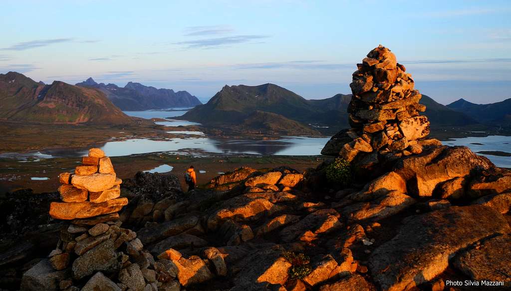
Hoven 368 m
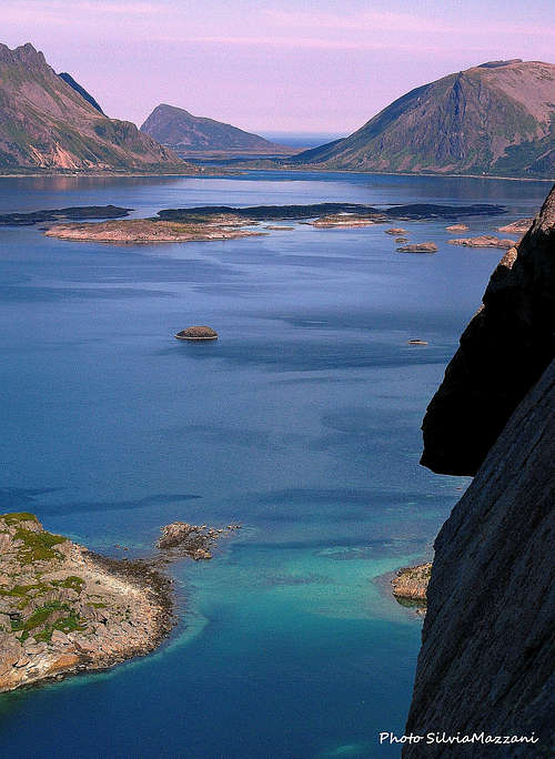
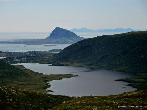
Hoven is a coastal peak overlooking the Norwegian Sea and located on the Northern sector of Gimsøy, a small island belonging to the Lofoten archipelago and located between the two larger island of Austvagøy to the East and Vestvagøy to the West. Its pyramidal shape is well visible and dominates the landscape to the North when you’re driving on the E10 Kong’s Olav route crossing from Gimsøy to Vestvagøy. With a height of only 368 meters, it’s not an important peak and it's probably the easiest summit to climb amid Lofoten mountain chains. Anyhow to climb Hoven is without any doubt an advisable outing, in reason of its “facing West” favorite situation, completely isolated on Gimsøy Northern coast. This fact makes the summit point an extraordinary panoramic place from which taking 360° views.
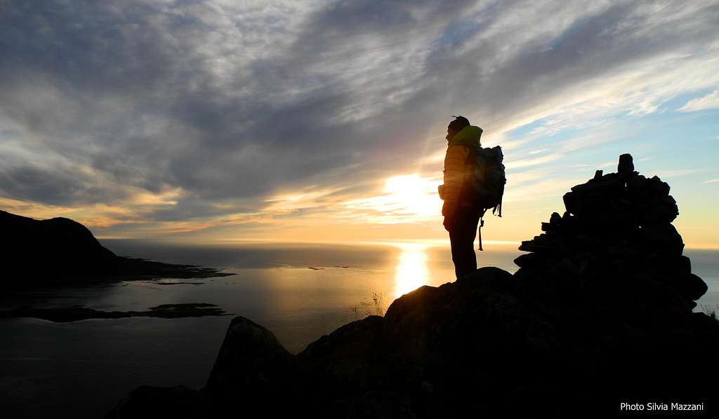
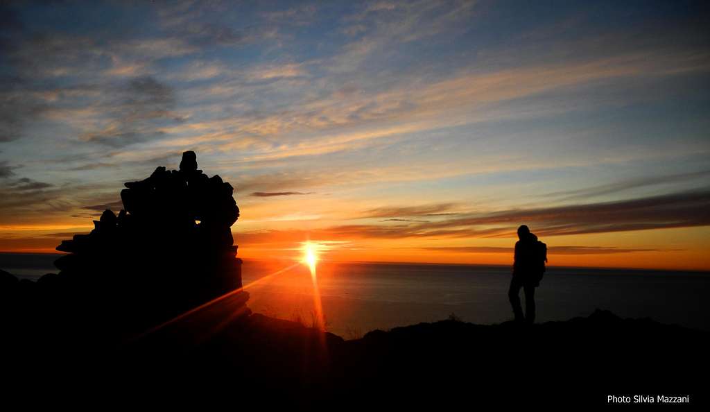
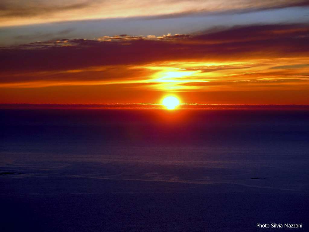
Moreover its quick and easy accessible standard route makes the mountain absolutely perfect for a night ascent, in order to observe during the clear nights the phenomenon of the midnight sun or, alternatively, the middle summer arctic sunset.
Getting There
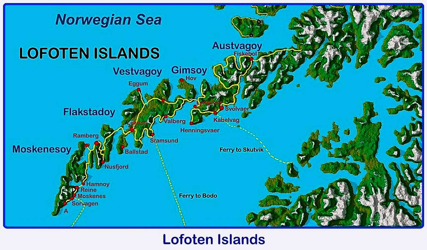
Getting to Lofoten Islands
There are various possibilities:
- By car from Evenes Airport to Svolvær
- By ferry boat from Bodø to Moskenes, Værøy or Røst (South of Lofoten)
- By ferry boat from Skutvik to Svolvær or Skrova (North of Lofoten)
- By plane from Bodø
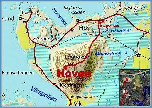
The reference point to climb Hoven is the small village of Hov, on the Northern coast of Langøy Island.


Getting to Hov
From Svolvær, Lofoten main town, take the E10 Kong’s Olav route towards Leknes and , cross the bridge connecting Austvagøy to Gimsøy, then leave the main road E10 and take the road n. 861 following the signpost to Hov and Lofoten Golf Links, getting a road fork. Here turn to left, reaching the village of Hov and park near the Lofoten Golf Links.
A midsummer sunset from the summit of Hoven
I strongly recommend this destination on clear days to enjoy the incredible summit views or, even better, as a class destination to watch the midnight sun observable on Lofoten from May 20 to July 17, or later in the season, after July 17th, to contemplate the middle summer arctic sunset. Hoven can be also be choosen as short walk when the weather is uncertain and the fog envelops the highest summits.
Hoven standard route report
Hoven West Flank Route
Summit altitude: m. 368
Difficulty: Easy walk
Vertical gain: 368 m
Exposure: West
Starting point: Village of Hov - Gimsøy Island

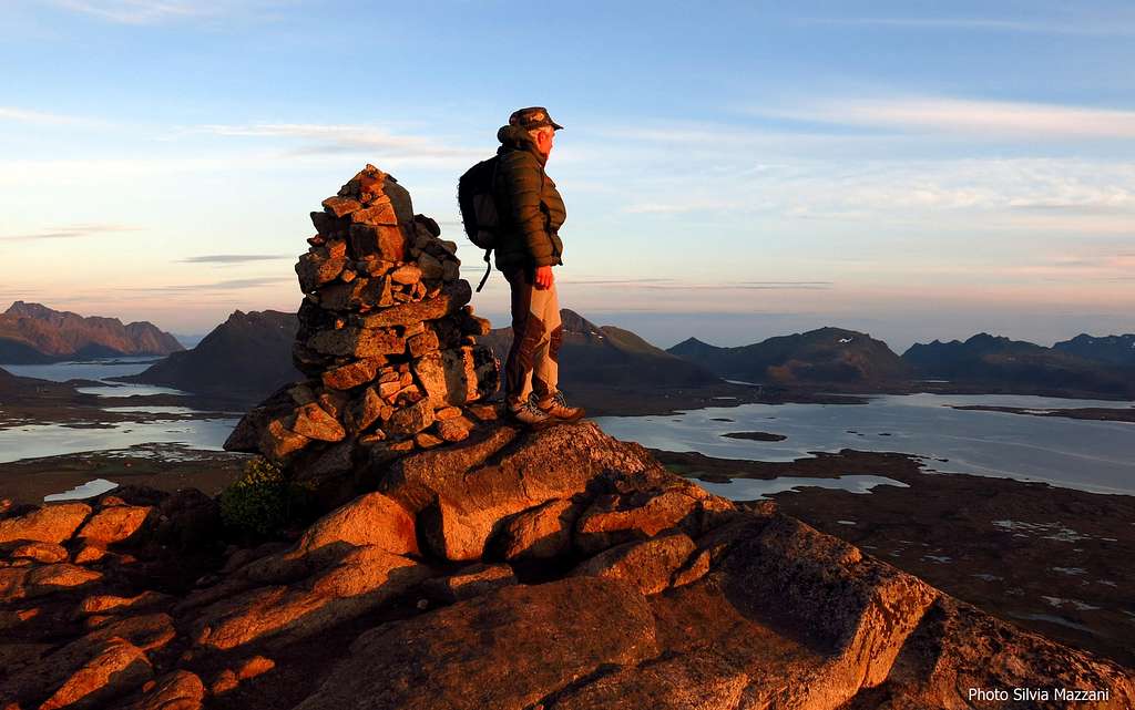
Hoven has a modest elevation and it is easily climbed on a gentle angled route, following the main trail starting from the village of Hov; despite the modest elevation the summit views are wide and impressive over Lofoten seascape, the surrounding peaks and the Vesterålen islands across the sea to the North-East. An easy and brief but unforgettable outing!


Route description
From the parking area near the golf links, walk south towards South following an obvious gravel road (signposts "Hoven") heading to a building looking like a small hangar. Nearby the building leave the main gravel road - don't follow it - and take an obvious trail wandering at first through a flat ground, then starting soon to rise. Anyhow all the tracks converge in a well worn path and you follow the obvious route heading towards West up the flank of the mountain.


There are a few small easy rocky steps, but the most part the trail rises amongst the low arctic vegetation. After 1 hour you reach the summit marked by various cairns. When you are on the top pay attention to the rocky East side dropping down steeply!
Red Tape
There are no particular restrictions in hiking.
Climate
On Lofoten the weather can change suddenly from clear and blu sky with sunshine or the Northern Lights (Aurora Borealis) to violent storms with rain or snow. Maximum temperatures go from +30°C in June and July to -15°C in January and February; the average temperatures for these months are from +12°C to -3°C. The period with the minimum rainfall goes from April to June, while we may expect the maximum rainfall or snowfall between October and December.
Midnight sun: from 27 May to 17 July
Polar night: from 6 December to 6 January
The Northern Lights can be seen over Lofoten from September to April.
Useful info about climate: Meteorologisk Institutt
| Month | Avg Low | Avg High | Precipitation (mm) | Wet Days | Daylight (Hours) |
| January | -2°C | 1°C | 65 | 18 | 5 |
| February | -2°C | 1°C | 60 | 17 | 10 |
| March | 0°C | 3°C | 65 | 18 | 14 |
| April | 1°C | 5°C | 55 | 17 | 20 |
| May | 5°C | 9°C | 55 | 18 | 24 |
| June | 7°C | 12°C | 70 | 18 | 24 |
| July | 9°C | 15°C | 65 | 18 | 24 |
| August | 8°C | 15°C | 90 | 20 | 22 |
| September | 7°C | 13°C | 100 | 22 | 15 |
| October | 5°C | 8°C | 110 | 23 | 10 |
| November | 3°C | 6°C | 85 | 19 | 6 |
| December | -1°C | 3°C | 75 | 19 | 2 |
When to Climb
Best months to climb are late May, June, July and August.
Midnight sun in Lofoten: from May 27th to July 17th
Polar night: from December 6th to January 6th
Accomodation
On Lofoten - as usually in Norway - free camping is allowed if not expressly forbidden. Anyhow there’s plenty of other accommodation, as hotel, b&b and the typical Norwegian "rorbuer" and cabins.
Meteo
Guidebooks and Maps
"Hiking the Lofoten Islands" - David Souyris, Magdalena Brede - 60 day hikes and a Trek across the archipelago, 2017
Turkart 1:50.000 – Vestvågøy
External Links
Tourist info:
Lofoten Islands
Lofoten