


-
 5025 Hits
-
 81.84% Score
-
 14 Votes
|
|
Mountain/Rock |
|---|---|
|
|
45.73000°N / 7.32306°E |
|
|
Mountaineering |
|
|
10121 ft / 3085 m |
|
|
Note
|
La montagna chiama i suoi figli, ed essi rispondono fedelmente al suo appello… Osvaldo Cardellina, Diario alpinistico, 1964-65 Page texts: @ OsvaldoCardellina "Osva", passed away on May 2, 2022. Page owners: Christian Cardellina e Osvaldo Cardellina. Any updates from September 12, 2022: Antonio Giani, page administrator, friend and climbing companion. Testi della pagina: @ OsvaldoCardellina "Osva", scomparso il 2 maggio 2022. Proprietari pagina: Christian Cardellina e Osvaldo Cardellina. Eventuali aggiornamenti dal 12 settembre 2022: Antonio Giani, amministratore della pagina, amico e compagno di salite. |
Overview
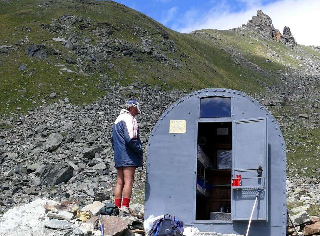
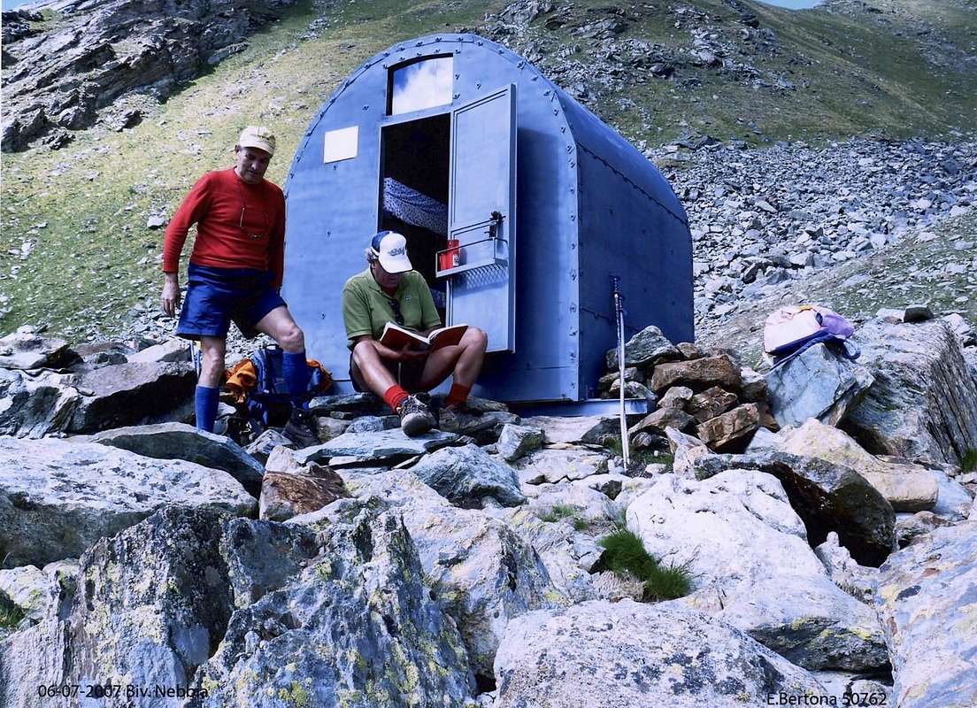
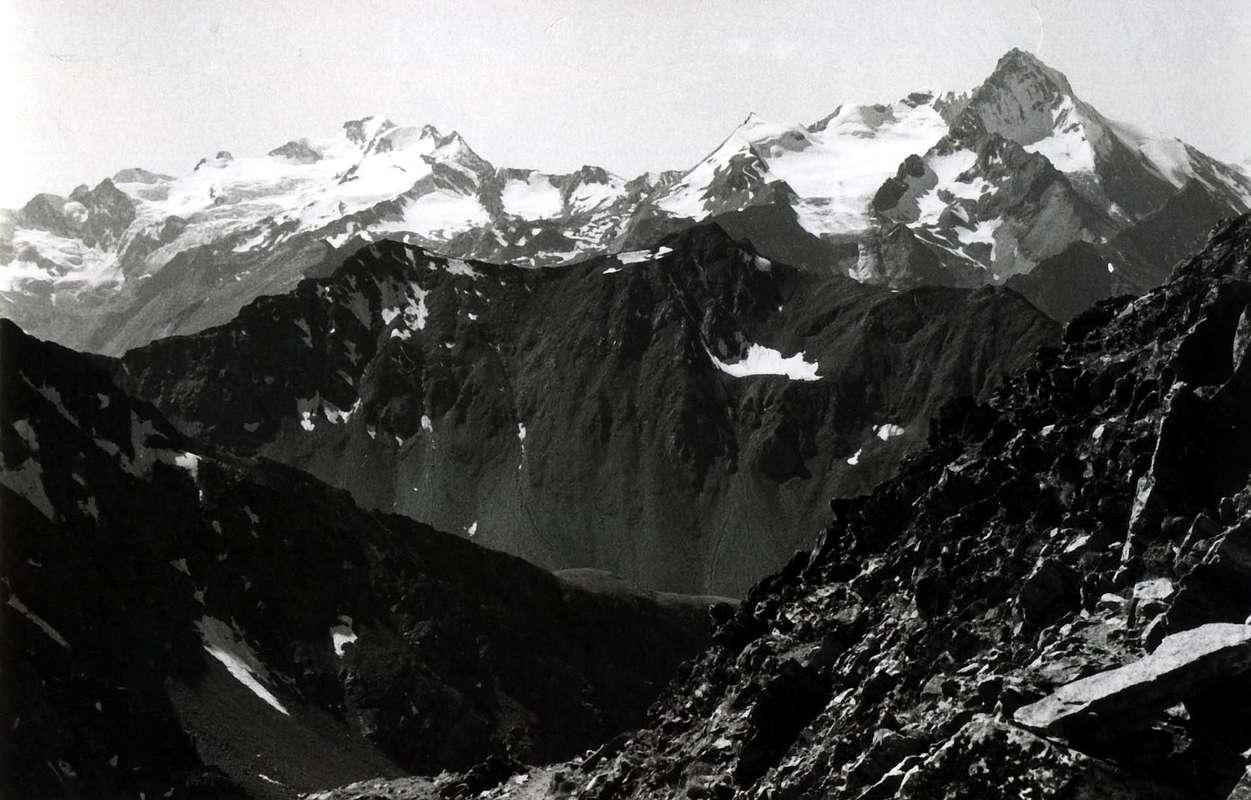
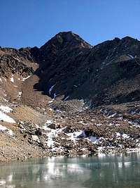
Also this Summit is not existed in time. Fact has existed, but only physically. But no one had noticed, because people notice only to those who already have a name. The rest does not matter, or, at least, it is absolutely unnecessary. Better to chase the big names, where, unfortunately, hastens to ground. To us, who rather like to look for unusual things, this affects. The Tip of Pian Bessey is nothing more than the tip above the eponymous plateau above the Valley of Cogne, in the Village of Gimillan and the upper Vallon Arpisson with its lonely Pasture. One of the many Arpisson that exist in Aosta Valley. Then simply means the Walloon of the Alps. What on where you live. After this pasture, the trail leads to a plateau, the Pian Bessey, below the Garin Hill, Bivouac Franco Nebbia, Lake and the "gruff" Pic Garin (3.451m). From there, over the hill, stands a tip that few people know.
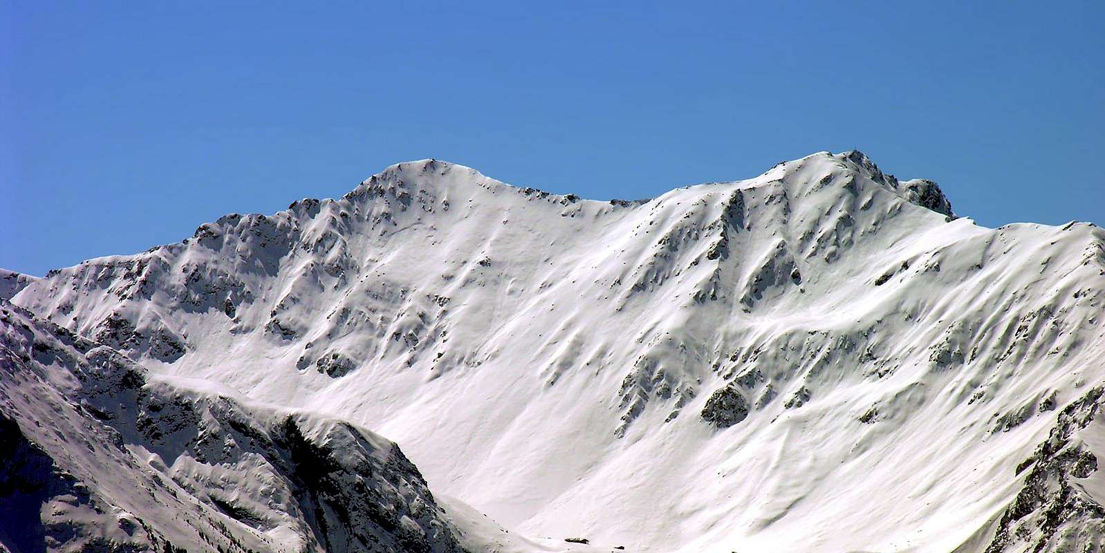
The Tip of Pian Bessey. Still further, to Pila, it raises the Punta della Valletta (3.090m), which everyone knows, at least for some time. For nearly 150 years, since before she "did not exist". The Punta di Pian Bessey is its great Eastern shoulder, but for a few metres, does not exist or, if it exists, everyone pretends not to notice this. It has a clear ridge to the Col Garin (2.815m), the other is secondary to the South-soutwest over the unfathomable precipices, and a third Northwestern, short and almost flat that reached the useless Hill of the Valletta (around 3.000 meters), dates back to the Punta della Valletta. No one leaves home to go to Punta Pian Bessey but since when was it placed the Bivouac Nebbia, someone leaves. Are only local people who make them from Cogne visit. Many here go up to the lake, a few daring instead to the pyramid of Garin, in full view from the Summit of Pian Bessey. Before there were only hunters. Under the ridge. All others go to Emilius, someone at Punta Rossa and others, even fewer at the Punta Garin. However, if you want to do something different, go to Punta Pian Bessey. You will not find climbing "glorious" and even passages in rock extremes. But you can find a great peace and unusual landscapes, that they give you another Southern Side of the Group of Emilius. And also, knowing look, great Alpine Stars.Of this "heap of stones". What can we say? Almost 3.100 meters high, is placed between the Col Garin (2.815m) and the Col of the Valletta, the Eastern end of that long watershedd between the Cogne valley and the Basin of Pila-Resort, just over Aosta Town; from the Tip of the Valletta (3.090m) is divided: one branch goes North to Mont Bellefaçe and Testa Nera to end with the Punta del Dard (2.033m). A second, much more extensive, down to the Col de Tsa Setze then head to the Northwest to Punta de la Pierre (2.653m), on the border between the Municipalities of Jovençan and Aymavilles. Do not expect to find satisfaction in climbing here, but an island of Peace and, we have said above, beautiful and great Edelweiss. But if you go down the Northeast Ridge from the Col Garin, on the edge of the ridge, you can find something. Maybe in a storm. Immediately below instead halls Centuries track of Chamois Hunters, but it is trivial and not worth attending. Maybe in a storm. Immediately below instead halls Centuries track of Chamois Hunters, but it is trivial and not worth attending. From the Tip of Valletta, on the other hand, is a beautiful, easy and scenic journey. Maybe meet a herd of goats, that dwell here. Avoid the other hand the other slopes that are tiring, boring and poorly remunerative, including those on the South Slope. In fact, a small spur leads down to the Southsouthwest to Share 2.974 meters; this serves as a "pivot" by dividing the same into two sections: one to the Southwest in the direction of the Hill Tsa Setze (on the old road leading to the Pass of Valletta) and a second straight for Southeast over the real Plan Bessey. A number of channels grassy-rocky climb towards Northeast Ridge above the Col Garin. Do not be "fooled" even though the apparent promise "shortcuts" (especially toward shoulder 2.936 meters). They are all steep and dangerous, as incidentally also the way on the other side is directed from the trail Northeast to the Col Tsa Setze, reaching that of Valletta. From Summit beautiful views on the Group Emilius with the near Becca di Nona, along the Vallon of Arbolle, Punta Rossa, Pic Garin and Arpisson's Tower; on the other side of the Chain of entire Gran Paradiso and to the underlying Cogne with its white Belltower, that rises above the its splendid "Prato di Sant'Orso" (Lawn of St. Ours).
 |
 |
 |
Anche questa Sommità non é esistita nel tempo. Anzi lo é, ma solo fisicamente. Però nessun se n'era accorto, perché la gente s'avvede sol di chi possiede già nome. Il resto non conta, o, perlomeno, diventa assolutamente superfluo. Meglio rincorrere i grandi nomi, dove, purtroppo, accorre la massa. A noi, cui invece piace cercar le cose inusuali, ciò interessa. La Punta di Pian Bessey altro non é che la Punta sovrastante l'omonimo pianoro, al di sopra della Valle di Cogne, del Villaggio di Gimillan e del superiore Vallone dell'Arpisson col suo solingo Alpeggio. Uno tra i tanti Arpisson ch'esiston in Valle di Aosta. Che poi semplicemente vuol dire il Vallone dell'Alpe. Quello sopra dove tu abiti. Dopo questa alpe, il sentiero introduce ad un pianoro, quello di Pian Bessey, al di sotto de Col Garin, del Bivacco Franco Nebbia, dell'omonimo Lago (2.854 m) e dell'"arcigna" Punta Garin (3.451 m). Di là, oltre il colle, s'innalza una punta che pochi conoscono. La Punta di Pian Bessey. Ancor più in là, verso Pila, s'eleva la Punta della Valletta (3.090 m), che invece tutti conoscono, almeno da qualche tempo. Da circa 150 anni, perché prima anche lei "non esisteva". La Punta di Pian Bessey é la sua grande spalla Orientale, ma, per pochi metri d'altezza, non esiste o, se esiste, tutti fan finta di non accorgersi di questo. Presenta una cresta evidente verso il Col Garin (2.815 m), un'altra secondaria a Sud-sudovest al di sopra di insondabili dirupi, ed una terza o Nordoccidentale, breve e quasi pianeggiante che, raggiunto l'inutile Colle della Valletta (3.000 metri circa), risale alla Punta della Valletta. Nessun parte da casa per andare alla Punta di Pian Bessey ma, da quando é stato piazzato il Bivacco Franco Nebbia, qualcun ci và. Son quasi esclusivamente abitanti del posto che da Cogne/Gimillan le van far visita. Molti qui salgon per il Lago, pochi invece verso l'ardita piramide della Garin, ben in vista dalla Punta di Pian Bessey. Prima lì andavan sol Cacciatori. Sottocresta. Tutti gli altri si recano all'Emilius, qualcuno alla Punta Rossa ed altri, ancor d'inferior numero, alla Garin. Però, se vuoi far qualcosa di diverso, vai alla Punta di Pian Bessey. Qui non trovi arrampicate "gloriose" e neppure passaggi in roccia estremi. Trovi però una grande Pace e paesaggi inusuali, che ti regalano un'altra faccia del Gruppo dell'Emilius. Ed anche, sapendo cercare, grandi Stelle Alpine. Di questo "mucchio di pietre" cosa possiam dir? Alto quasi 3.100 metri, é collocato tra il Col Garin (2.815 m) e quello della Valletta, all'estremità Orientale di quel lungo spartiacue tra la Valle di Cogne ed il Bacino del Centro Turistico di Pila, appen sopra d'Aosta. Dalla Punta della Valletta (3.090 m) si divide: un ramo scende a Nord verso Mont Bellefaçe e Testa Nera per terminare con la Punta del Dard (2.033 m). Un secondo, ben più esteso, scende al Colle di Tsa Setze per poi dirigersi a Nordovest fino alla Punta de la Pierre (2.653 m), sopra il confine tra i Comuni di Jovençan ed Aymavilles. Non pensar di trovar qui soddisfazioni arrampicatorie, ma un'isola di Pace sì ed anche, già detto, splendidi Edelweiss. Se percorri la Cresta Nordest dalla "Bassa" di Garin, sul filo, qualcosa trovi. Magari sotto un temporale. Subito al di sotto invece sale da Secoli una traccia di Cacciatori di Camosci, ma é banale e non merita frequentazione. Dalla Punta della Valletta, invece, é una bella, facile e panoramica traversata. Magari incontrando un branco di capre, qui spesso alberganti. Evitar invece gli altri pendii che son faticosi, noiosi e scarsamente remunerativi, compresi quelli sul Versante Meridionale. Infatti un piccolo contrafforte scende verso Sud-sudovest fin alla Quota 2.974 metri; questa funge da "perno" dividendo il medesimo in due settori: uno a Sudovest in direzione del Colle di Tsa Setze (sull'antica via che conduceva al Colle della Valletta) ed un secondo decisamente verso Sudest al di sopra del vero e proprio Plan Bessey. Una serie di canali erboso-rocciosi salgono in direzione della Cresta Nordest sopra il Col Garin. Non farsi "ingannar" anche se prometton apparenti "scorciatoie" (soprattutto verso la spalla 2.936 metri). Son tutti ripidi e pericolosi, come daltronde anche la via che all'opposto s'indirizza dal sentiero per il Colle Tsa Setze verso Nordest raggiungendo quello della Valletta. Dalla Sommità splendide viste sul Gruppo dell'Emilius e, con lo stesso, della vicina Becca, del lungo Vallone di Arbolle, su Punta Rossa, Pic Garin e Torre d'Arpisson; sul lato opposto sull'intera Catena del Gran Paradiso e sulla sottostante Cogne col suo splendido e bianco Campanile, che svetta al di sopra del verdeggiante "Prato di Sant'Orso".
First Ascents
- Firs on the Summit: Unknown.
- First ascent in winter: Unknown.
- N Slope: Osvaldo Cardellina, lone; (Apr 21th, 2005), in descent towards Arbolle Vallon, Garin Hill, Arpisson Alp, Gimillan Hamlet.
- E-NE Ridge: Osvaldo Cardellina and Christian Cardellina; (Jul 22th, 1983), in descent integral towards Garin Hill.
- S Edge: Osvaldo Cardellina, lone; (Apr 21th, 2005), in ascent from Gimillan Hamlet, Arpisson Pasture towards Pian di Bessey.
Getting There
BY CAR:
- From TORINO, MILANO, etc: Motorway A5. Exit at IVREA or Quincinetto (PIEDMONT).
- From IVREA Town: Charvensod, Gressan, Jovençan, Aymavilles Municipalities.
- From Charvensod to Dard-Comboé-Arbolle Vallons towards Ponteilles (1.697m) Alp & Waterfall, through dirt road, Comboé Alp & Saint Ours private Shelter (2.114m), through dirt road, and Arbolle Refuge (2.516m), nearby Lakes (2.495m, 2.497m), by Chair Lift to Chamolé Station (2.309m), Lake (2.325m) and muletrack. From Charvensod (main road from Pont Suaz 567m) or Gressan (603m; alternative road) to Tivet, Les Fleurs Hamlets (1.292m, 1.414m) Pila Basin and Resort (low parking nearby Cableway 1.800m; upper parking 1.850m). Arno Shelter (2.660m), always open but unguarded, nearby Couiss Summit on watershed Pila/Cogne Valley. From Jovençan (631m) to Western Pila Conca, exclusively through path-muletrack to Tourlin Dessous (1.466m) and by dirt road to Pila-Posse Tennis (1.776m). From Aymavilles (646m) to Western Pila Conca, through Main Road to Cogne Valley, alternative road to Ozein/Turlin Dessus Hamlets and dirt road to Pila-Posse. From Aymavilles (646m) towards Cogne Valley: Vieyes (1.132m), Epinel (1.430m), Crétaz (1.494m) to Cogne (1.534m); through Main Road. From this to Montroz and Gimillan Villages (1.785m), Franco Nebbia Bivouac (2.740m), with path in Arpisson Vallon.
- From FRANCE: through the Mont Blanc Tunnel to Entrèves-crossroads to Vény/Ferret Valleys - Mountain Guides of Courmayeur - La Saxe Rock Gym - Courmayeur. By Little Saint Bernard Pass, closed since November until half May to La Thuile Valley - Pré Saint Didier - Courmayeur. It is not necessary to take Motorway A5: you can drive on SS.26, in the direction of AOSTA - IVREA - TURIN.
BY PLANE:
- Aeroporto "Corrado Gex" Saint Christophe (Aosta).
Approaches
 |
Approach A from Pila Resort: From Pila (around 1.800/50 meters) famous ski Resort easy and fastly reachable from Aosta Town using car, bus or cableway), get the Chamolé Lake (2.325m) on foot through the various paths n° 19/19A/19B, passing respectively to the Alpage of Chamolé (2.532m; fountain), also towards the Bois (Wood) Chanté, going up directly into a small walloon to Chamolé Lake (2.325m). Or by a chairlift to Upper Station (2.311m), and the homonymous hill above (2.641m). Wherefrom the Normal Route (Northeast Crest) starts also from the ones arriving here from Arbolle Walloon. From here begins the Normal Route (Northeast Ridge) for those who received from Arbolle. This will then approach the Testa Nera (2.820m) and with easy crossing to the South Mont Bellefaçe (2.970m) and the Punta della Valletta (3.090m), immediately to the West of Punta di Pian Bessey, where the watershed divides by sending a branch to the East towards the latter and another to the Southwest over the Col de Tsa Setze or Sèche also even Sètse (2.815m).
Avvicinamento A dal Comprensorio di Pila: Da Pila (circa 1.800/50 metri, nota località sciistica, raggiungibile da Aosta in auto pullman o funivia), raggiungere il Lago di Chamolé (2.325 m, anche qui in seggiovia o a piedi fino alla Stazione Superiore (2.311 m) tramite i vari sentieri n° 19/19A/19B) che passano rispettivamente per l'Alpe di Chamolé (2.532 m; fontana), oppure attraverso il Bois Chanté, salendo direttamente tramite un valloncello al Lago di Chamolé (2.325 m) e l'omonimo colle superiore (2.641 m). Da qui inizia la Via Normale (Cresta Nordest) anche per chi perviene da Arbolle. Questa raggiunge in successione la Testa Nera (2.820 m) e con facile traversata a Sud il Mont Bellefaçe (2.970 m) e la Punta della Valletta (3.090 m), subito ad Ovest della Punta di Pian Bessey, dove lo spartiacque si divide inviando un ramo ad Oriente verso questa ultima ed un altro a Sudovest sopra il Colle di Tsa Setze o Sèche o Sètse (2.815 m).
Approach B Arbolle Refuge: from the Arbolle new Hut near the Lake with the same name (2.516m, reachable from the Cogne Valley starting from Gimillan Hamlet (1.787m) through the Vallon of Arpisson, the Bivouac Franco Nebbia (2.740m) and the Garin Hill (2.815m) through the trails n° 2 and down in the Vallon of Arbolle through n° 18) ford the torrent in a small cove at the old barn and started to go up with large bends between grassy slopes through the path n° 18/TVC; with a diagonal progressively towards the North and a steep section at the terminal easily and quickly you get to Chamolé Hill "suspended" over the Vallon of the Comboé, whence the Northeast Ridge towards Testa Nera (T/E; 0h'30).
Avvicinamento B dal Rifugio di Arbolle: dal nuovo Rifugio di Arbolle presso l'omonimo Lago (2.516 m; raggiungibile anche dalla Valle di Cogne con partenza dal Villaggio di Gimillan (1.787 m) tramite il Vallone di Arpisson, il Bivacco Franco Nebbia (2.740 m) ed il Colle Garin (2.815 m) tramite i sentieri n° 2 ed in discesa nel Vallone di Arbolle n° 18) guadare il torrente in una piccola ansa presso la vecchia stalla ed iniziare a salite con larghi tornanti tra pendii prativi tramite il sentiero-mulattiera n° 18/TVC; con un diagonale progressivamente verso Nord ed un tratto più ripido nella parte terminale facilmente ed in breve tempo si arriva al Colle di Chamolé "sospeso" al di sopra del Vallone del Comboé, donde alla Cresta Nordest per la Testa Nera (T/E; 0h'30).
Approach C from the Vallon of Comboé: by Comboé (2.114m; private retreat of the Canons of Saint Orso) reachable by the below Ponteilles Alpage (1.697 m; beautiful waterfall) through the path n° 14 or from Pila-Resort via the Plan Fenêtre Hill (2.229m), through the path n° 16, you can reach the Chamolé Upper Chair lift Station, and homonyms Lake and Hill with two other possibilities:
 |
 |
 |
 |
 |
1) - immediately behind the shelter apart from the steep path n° 19 rather than through hairpin bends to reach the North Col Replan (2.366m); from this a wider path down to the Southwest towards Lake Chamolé (yellow signs) where you reconnect with the previous Approach A.
2) - it is also possible to reach the Refuge Arbolle with a larger circle to the South along the Comboé tableland that, after reaching the Alp derelict Grand Plan (2.158m), crosses the Torrent de Comboé with a diagonal from right to left in the middle of a heap of stones; the route n° 16 at this point enters a very narrow gorge with very tight bends reaches him, hence the Approach B (calculated both from 1h'30 to 1h'45 to the hill).
Avvicinamento C dal Vallone di Comboé: da Comboé (2.114 m; rifugio privato dei Canonici di Sant'Orso) raggiungibile dal sottostante Alpeggio di Ponteilles (1.697 m; bella cascata) tramite il sentiero n° 14 oppure da Pila tramite il Colle Plan Fenêtre (2.229 m), per mezzo del sentiero n° 16, si può raggiungere Seggiovia, Lago e Colle di Chamolé con due altre possibilità:
1) - da subito dietro il rifugio parte il ripido sentiero n° 19 che, tramite alquanto stretti tornanti, raggiunge il Colle Settentrionale di Replan (2.366 m); da questo un sentiero più largo scende a Sudovest verso il Lago di Chamolé (indicazioni in giallo) dove ci si riconnette col precedente Avvicinamento A.
2) - Inoltre é possibile raggiungere il Rifugio d'Arbolle con un giro più largo verso Sud che lungo il pianoro del Comboé, dopo aver raggiunto l'Alpe diroccata di Grand Plan (2.158 m), attraversa il Torrent de Comboé con un diagonale da destra verso sinistra in mezzo ad una pietraia; il sentiero n° 16 a questo punto entra in una strettissima gola e con tornanti altrettanto ristretti lo raggiunge, donde allo Avvicinamento B (1h'30/1h'45 al colle).

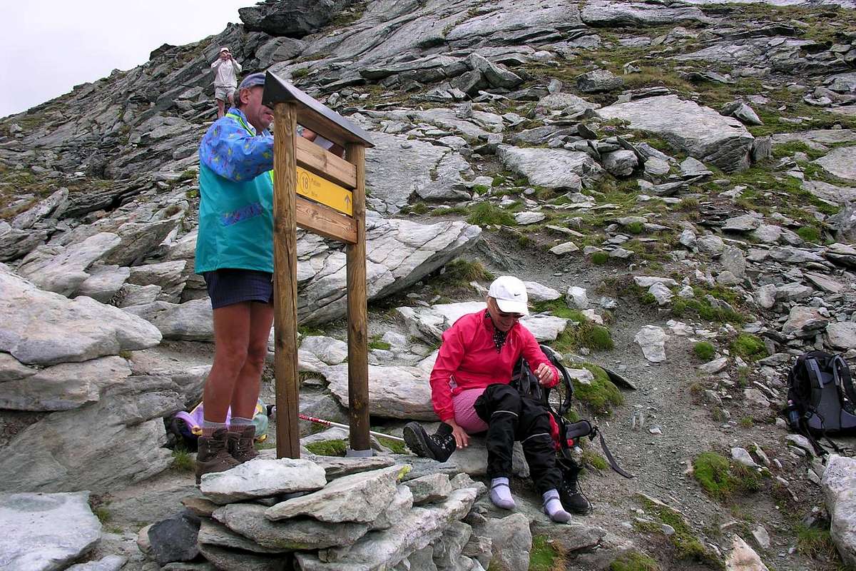
Approach D from the Vallon of Arpisson: the Garin Hill can also be reached from the Valley Cogne crossing in his entirety the Vallon of the Arpisson with departure from the Fraction of Epinel (1.452m) or, preferably, reaching the Pastures of the Arpisson (2.328m; spring) after a long crossroad from the Village of Gimillan (1.787m), through the path n° 3/TVC. From these, to climb the entire walloon through a good path that crosses it in his mean and, left to the left the deviation for the Hill of Tsa Setze, to reach an ample tableland known as Pian Bessey (Bessey Tableland; source), having to the shoulders for the whole slope the spectacular perspective of the Grivola. Before reaching the steep slant, that with narrow small hairpin bends reaches the pass, to continue to the right on a small trace reaching the Bivouac Franco Nebbia (2.740m; just above the same a path brings shortly time, supporting himself in a small debris walloon, as soon as more on the right or East, to the Western bank of the Lake Garin). From the bivouac the path bending in the Northwest rooms eighty metres with very narrow hairpin bends to the pass (E; 2h'45/3h'15 from Gimillan Hamlet; 4h'00/4h'30 from Epinel Fraction). From this last Village (1.430m) you can reach the Arpisson Alpage with trail n° 2, which crossed the torrent to the Northeast of the same name, first reach the Alpe di Teuvre (1.792m) and then changing the direction in Northwest, to Tsavanis (1.859m, where comes the path n° 3A, starting from Gimillan). The last stretch more to the North, crossed again the torrent to the Alp Arpisson (E; 2h'15/2h'45).
Avvicinamento D dal Vallone di Arpisson: Il Colle Garin può esser raggiunto anche dalla Valle Cogne percorrendo nella sua interezza il Vallone dell'Arpisson con partenza dalla Frazione di Epinel (1.452 m) oppure, preferibilmente, raggiungendo gli Alpeggi dell'Arpisson (2.328 m; sorgente) dopo una traversa lunga dal Villaggio di Gimillan (1.787 m), tramite il sentiero n° 3/TVC. Da questi, salire il vallone tramite un buon sentiero che lo percorre nel suo mezzo e, lasciata a sinistra la deviazione per il Colle di Tsa Setze, raggiungere un ampio pianoro-altipiano noto come Pian Bessey, avendo alle spalle per tutta la salita la prospettiva spettacolosa della Grivola. Prima di raggiungere il più ripido pendio, che con stretti tornantini raggiunge il colle, proseguire su di una piccola traccia più a destra raggiungendo il Bivacco Franco Nebbia (2.740 m; subito sopra lo stesso un sentiero porta in breve tempo, appoggiandosi in un valloncello detritico, appena più sulla destra od Est, alla sponda Occidentale del Lago Garin). Dal bivacco il sentiero piegando a Nordovest sale per un'ottantina di metri con stretti tornantini raggiungendo il colle (E; 2h'45/3h'15 dal Villaggio di Gimillan; 4h'00/4h'30 dalla Frazione di Epinel). Da questa frazione (1.430 m) si può raggiungere l'Alpe di Arpisson con il sentiero n° 2 che, attraversato verso Nordest l'omonimo torrente, raggiunge dapprima l'Alpe di Teuvre (1.792 m) e poi, cambiando la direzione in Nordovest, quella di Tsavanis (1.859 m; dove arriva anche il sentiero n° 3A partendo da Gimillan). Un ultimo tratto più a Nord, attraversato nuovamente il torrente, raggiunge l'Alpe di Arpisson (E; 2h'15/2h'45).
On Northwest Ridge to Punta della Valletta
Northeast Ridge above Garin Hill and between Arbolle/Arpisson Vallons
 |
 |
 |
 |
 |
Routes
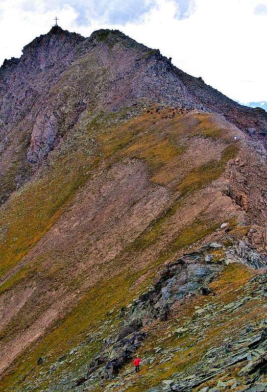
Routes A, B and C from Chamolé Hill, "Via degli Alpini" on West-northwest Slope also from Tsa Setze Hill by "Via Ferrata" and Southwest Crest): From Chamolé Hill (2.641m, reachable from the Chair Bettères (Pila)/Chamolé and Lake (2.325m) of the same name) or, again starting from the same along the "Via degli Alpini" reach first the Mont Bellefaçe (2.970m) and then the Punta della Valletta (3.090m, or by using the "Via Ferrata", set up since 2003, rising from the Hill of Tsa Setze along the Southwestern Ridge; EE from F+ to PD-; 1h'30/2h'00 for both). From this reach with a short descent to his Eastern Ante Summit (3.070 meters; salle à manger); continue with a forty meters by easy rocks and broken blocks composed of brownish and then on an easy track towards East which, after a grassy hump and rounded, the Hill of Valletta (around 3.000 meters; in practice unusable on both sides). From this climb on "flat" Ridge Northwest, the same direction, at first on a grassy slope at the edge of the pink rocks by easy rocks leading out to a terrace under some rocks that form the Summit. Go up the same directly from the West or with a short bypass to the South, on a small ledge, reaching the Top (EE/F; 0h'35/0h'45 from the Punta della Valletta; 2h'00/2h'30 from Chair lift Upper Station; 3h'30/4h'00 from Pila-Resort)). In any case, the easiest way, because it signaled, it remains one of the Hill Chamolé also for the fact that allows you to lean on the Refuge Arbolle. Also worthy of note, that in case of sudden change in the weather, you can go directly to the shelter by the steep but easy scree slopes from the Hill of Valletta. In this case, you gain much time by not remain dangerously on the therad of the ridges. The route by the "Via Ferrata" is not difficult but is exposed and requires the proper equipment and various tools required. Absolutely to avoid bad weather, because significant exposure to lightning as well as stay on the Summit, which causes high iron Cross, works as true and real lightning rod. Not wanting to go down to the Arbolle Shelter, does the quick "Via degli Alpini" Slope West-northwest along that quickly allows the same to the Chair lift Station (check timetable; generally closing around 17:00/17:30, while the morning departure to Lake Chamolé place around 09.00 from Bettères). These times allow quietly day trip from Aosta by Pila Pila, doing, ascent and descent, saving about 1.000 meters in altitude with rather strenuous path along the "Trail of the Woods" (Ski Run).
 |
 |
 |
 |
 |
Vie A, B e C (dal Colle di Chamolé, tramite la "Via degli Alpini" sul Versante Ovest-nordovest oppure dal Col Tsa Setze con la "Via Ferrata" e la Cresta Sudovest): Dal Colle di Chamolé (2.641 m; raggiungibile dalla Stazione della Seggiovia di Bettères (Pila)/Chamolé ed omonimo Lago) o, sempre partendo dalla medesima, lungo la "Via degli Alpini" raggiungere dapprima il Mont Bellefaçe (2.970 m) e successivamente la Punta della Valletta (3.090 m; oppure tramite la "Via Ferrata", allestita dal 2003, che sale dal Colle di Tsa Setze lungo la Cresta Sudovest; EE da F+ a PD-: 1h'30/2h'00 per entrambe). Da questa arrivare con corta discesa all'Antecima Est (3.070 metri circa; salle à manger); continuare con una quarantina di metri tramite facili rocce spezzate e composte da blocchi brunastri e poi su d'una traccia verso Est raggiungendo, dopo una gobba erbosa arrotondata, il Colle della Valletta (3000 metri circa; in pratica inutilizzabile su di entrambi i versanti). Da questo prodedere sulla "piatta" Cresta Nordovest, stessa direzione, dapprima su d'un pendio erboso al margine di rocce rosate con facili rocce adducenti ad un terrazzo sotto alcuni roccioni costituenti la Sommità. Salire i medesimi direttamente da Ovest oppure con un breve aggiramento a Sud, su di una cengetta, arrivando sulla stretta Cima (EE/F; 0h'35/0h'45 dalla Punta della Valletta; 2h'00/2h'30 dalla Stazione Superiore della Seggiovia; 3h'30/4h'00 da Pila). In ogni caso la via più semplice, anche perché segnalata, rimane quella del Colle di Chamolé anche per il fatto che permette di appoggiarsi al Rifugio di Arbolle. Da segnalare, inoltre, che, in caso di cambiamento repentino delle condizioni atmosferiche, si può scendere direttamente allo stesso tramite i ripidi ma facili pendii detritici dal Colle della Valletta. In questo caso si guadagna decisamente del tempo evitando di restare pericolosamente sulle creste. Il percorso tramite la "Via Ferrata" non é difficile ma é esposto e richiede adeguato equipaggiamento ed attrezzatura. Assolutamente da evitare con cattivo tempo, perché notevolmente esposto ai fulmini così come la permanenza sulla Sommità, che, causa l'alta Croce in ferro, funziona da vero e prprio parafulmine. Non scendendo al rifugio, conviene la rapida "Via degli Alpini" lungo il Versante Ovest-nordovest che in breve tempo consente la medesima verso la Stazione Superiore della Seggiovia (informarsi sugli orari; generalmente chiusura intorno alle 17.00/17.30, mentre la partenza mattutina verso il Lago di Chamolé avviene intorno alle 09.00 da Bettères). Questi orari consentono tranquillamente la gita in giornata da Pila A Pila, facendo, tra salita e discesa, risparmiare circa 1.000 metri di dislivello con percorso piuttosto faticoso lungo la "Pista del Bosco".
 |
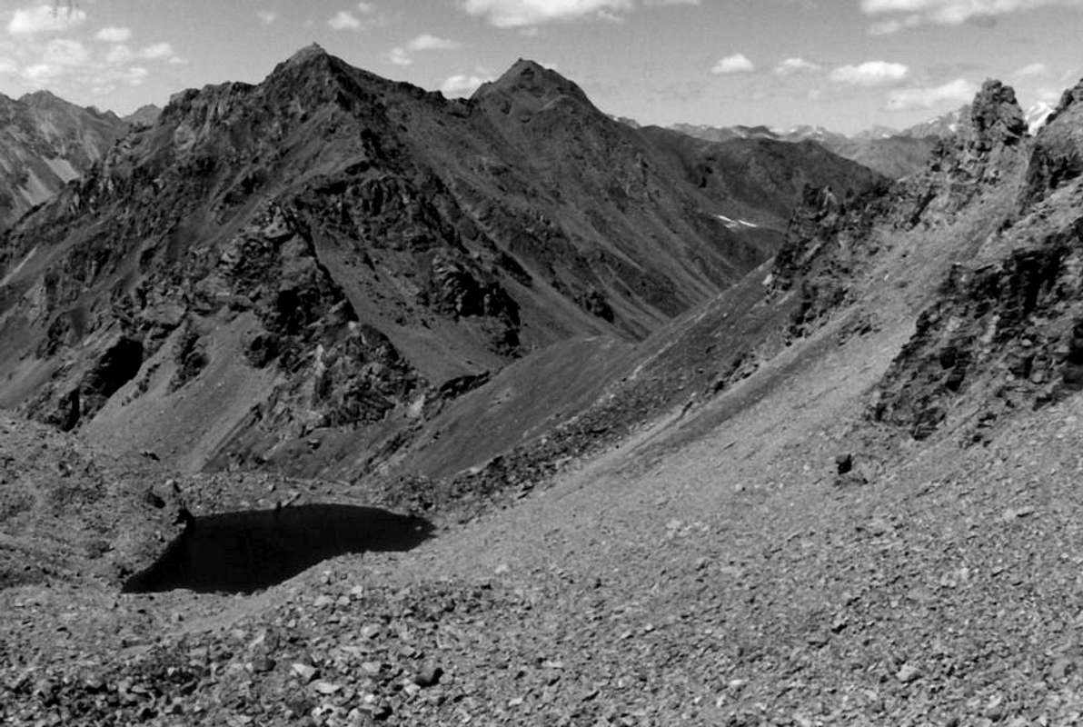
Routes D and E (from the Garin Hill by the Northeast Ridge): from the hill (2.815m, reachable from the Vallons of Arbolle or Arpisson) start to climb towards the Southwest with two possibilities:
1) - remaining under the ridge and on small tracks around the various bumps on the North Slope. The first part of 190 meters, the most challenging is bypassed completely to the right, through a steep debris flow grayish, reaching the crest where this becomes "flat" while the final stretch coincides, more or less, with that of the next itinerary, with some circumvention (EE; overall F/F+ from I° to II°- in final).
2) - Along the ridge with a gentle climb due to the friability of the rock. Reaching an initial elevation 2.856 meters, after passing in succession a short gray slab on the left followed by two prominences, which directly pass through very broken blocks and stacked (I°/I°+), coming to a sharp edge; this is bypassed right into a split ramp that leads to a tiny pulpit. From this coming in on the left to reach a jagged crest (II°/II°+/III°-). A small fork leads to a second 2.938 meters; this part is not difficult route on the edge of the ridge and then conclude with a chimney that leads just below the summit pinnacle (II°-/II°). After reaching a third less pronounced elevation of the ridge bends first to the West and then to the West-southwest, reaching the altitude 3.001 meters coming to the terminal turrit; this is overcome in the center (I°+/II°-), through rocky terrain and a large split in the final (EE/A; 270 meters from the hill; 1h'00/1h'15). This path has been followed in full downhill from Osvaldo and Christian Cardellina (10 years) July 22th, 1983, after crossing the Testa Nera, Mont Bellefaçe, Punta della Valletta and under a severe thunderstorm. Downhill, in this case, it should go down, as mentioned above, from the Hill of the Valletta through an oblique couloir of steep stones leading to the Southern shore of Lake Arbolle and soon after at the shelter in short time. Or, having to return to the Walloon of Arpisson by Col Garin, without then having to go back from the shelter, get only the first part of the Northeast Ridge to the quota 2938 metres and this cross the steep stony gray in the direction the hill without losing altitude. However, avoid being "attract" from the steep and dangerous grassy couloirs turned to the Southeast, that give the impression to shorten the course, but they are dangerous because of the presence of "Ollina".
 |
 |
 |
 |
 |
Vie D ed E (dal Colle tramite la Cresta Nordest): dal colle (2815 m; raggiungibile dal Vallone di Arbolle o da quello di Arpisson) iniziare a salire verso sudovest con due possibilità:
1) - restando sotto il filo di cresta e su piccole tracce aggirare le varie asperità sul Versante Settentrionale. Il primo tratto di circa 190 metri, il più impegnativo, viene evitato completamente a destra, tramite una ripida colata detritica grigiastra, raggiungendo la cresta dove questa diventa più "pianeggiante", mentre il tratto conclusivo coincide, più o meno, con quello dell'itinerario successivo, con qualche aggiramento (EE; complessivamente F/F+ dal I° al II°- nella parte finale).
2) - Percorrere il filo di cresta con un'arrampicata delicata causa la friabilità della roccia. Raggiungere una prima elevazione in altitudine 2.856 metri, dopo avere superato in successione una corta placca grigia sulla sinistra seguita da due elevazioni, che si superano direttamente, tramite blocchi molto rotti ed accatastati (I°/I°+), arrivando ad uno spigolo affilato; questo viene aggirato subito a destra per una spaccatura rampa che porta ad un minuscolo pulpito (II°/II°+/III°-). Da questo rientrando sulla sinistra si raggiunge una cresta dentellata. Una piccola forcella conduce verso una seconda elevazione in altitudine 2.938 metri; questo tratto non difficile viene percorso sul filo di cresta per poi concludere tramite un camino che conduce appena sotto il pinnacolo sommitale (II°-/II°). Dopo aver raggiunto una terza elevazione meno pronunciata la cresta piega prima ad Ovest e poi ad Ovest-sudovest raggiungendo la quota 3.001 metri arrivando alla torretta terminale; questa viene superata nel centro (I°+/II°-) per rocce rotte ed una grande spaccatura nel finale (EE/A; 270 metri di dislivello dal colle; 1h'00/1h'15). Questa via é stata seguita integralmente in discesa da parte di Osvaldo e Christian Cardellina (10 anni) il 22 Luglio 1983, dopo traversata dalla Testa Nera, Mont Bellefaçe, Punta della Valletta e sotto un forte temporale. In discesa, in questo caso, conviene scendere, come già detto sopra, dal Colle della Valletta tramite un canalone di pietrame obliquo conducente alla sponda Meridionale del Lago d'Arbolle e subito dopo al rifugio. Oppure, dovendo rientrare nel Vallone di Arpisson tramite il Col Garin, senza poi dover risalire dal rifugio, scendere solo la prima parte della Cresta Nordest fino alla quota 2.938 metri e da questa traversare le ripide pietraie grigie in direzione del colle senza perder di dislivello. Evitare comunque di farsi "attrarre" dai ripidi canaloni erbosi a Sudest, che donano l'impressione di accorciare il percorso, ma sono pericolosi causa la presenza d'"erba Ollina".
 |
Mountain Condition
- Meteo: you can find all the needed informations at the official site of the Valle d'Aosta Region:
- Valle d'Aosta Meteo
Books and Maps
- "Diari Alpinistici" di Osvaldo Cardellina e Indice Generale accompagnato da Schedario Relazioni Ascensioni 1964-2019 (inediti).
- "80 itinerari di Escursionismo Alpinismo e Sci Alpinismo in Valle d'Aosta", di Osvaldo Cardellina, Ed. Musumeci, Giugno 1977 (in Italian); seconda Ed. Luglio 1981; terza Ed. Luglio 1984; (in French), prima Ed. Febbraio 1978; seconda Ed. Marzo 1980.
- "Guida del Monte Emilius", di Osvaldo Cardellina Editore in collaborazione con il Club Alpino Italiano Sezione di Aosta, Dicembre 1978.
- "Guida dei Monti d'Italia – Emilius Rosa dei Banchi Parco del Mont Avic" di Giulio Berutto e Lino Fornelli-Club Alpino Italiano/Touring Club Italiano, Marzo 2005.
- "Guida delle Alpi Occidentali" di Giovanni Bobba e Luigi Vaccarone C.A.I. Sezione di Torino Volume II (parte II), 25 Maggio 1896.
 |
 |
 |
- Kompass "Gran Paradiso Valle d'Aosta Sentieri e Rifugi" Carta turistica 1:50.000.
- Hapax "Les Sentiers Comunità Montana Monte Emilius" Luglio 2000 1:25.000.
- Enrico Editore Ivrea-Aosta "Gruppo del Gran Paradiso" 1:50.000.
- I.G.C. Torino "Carta delle Passeggiate ed Escursioni in V.D.A. Conca di Pila-Gressan" 1:20.000.
Important Information
- REGIONE AUTONOMA VALLE D'AOSTA the official site.
- FONDAZIONE MONTAGNA SICURA Villa Cameron, località Villard de la Palud n° 1 Courmayeur (AO) Tel: 39 0165 897602 - Fax: 39 0165 897647.
- SOCIETA' GUIDE ALPINE DI COGNE Tel. 347/9473526 – 328/1373728.
- A.I.NE.VA. (Associazione Interregionale Neve e Valanghe).
- A.IA.T. Cogne Gran Paradis via Bourgeois n° 34 Tel. 0165-74040. E-mail: aiat@cogne.org
- Ezio Sport articoli sportivi - via Bourgeois n° 64 Tel. 0165-74204.
Useful numbers
- Protezione Civile Valdostana località Aeroporto n° 7/A Saint Christophe (Ao) Tel. 0165-238222.
- Bollettino Valanghe Tel. 0165-776300.
- Bollettino Meteo Tel. 0165-44113.
- Unità Operativa di Soccorso Sanitario Tel. 118.