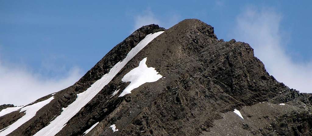
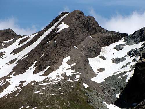
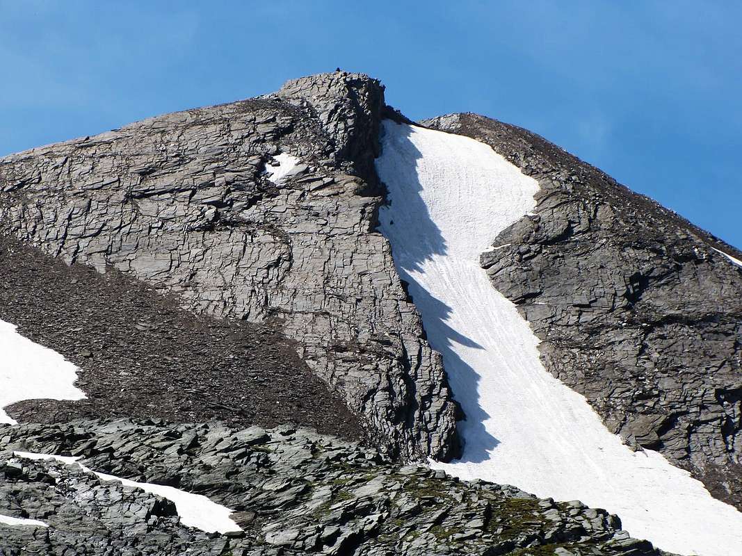
Mountain in the shape of plate triangle, sited in watershed ridge between Aosta Valley and Piedmont at North Eastern of Gran Paradiso Mountain Chain slopes, and towards of the Gran Paradiso National Park (you are just on the Southern border of the Park or P.N.G.P. in the recent maps) into a mountaineering unknown and a more unpopular area. The mountain chain from Torre Lavina (3.308m), in Southwest, to of Champorcher Fenêtre Pass, in Northeast (2.826m; Acque Rosse, Rancio, Scaletta, Nera, Miserino, Arietta, Nouva, Peradzà Black Rocks of Peradzà, Peradzà and Bec Costazza) non known a great frequentation, but after the of Sogno di Berdzé Hut construction, neighbor the old Peradzà Alp, a better impulse extant, at least for more in Eastern mountains of the same chain. On the contrary more known the pass, "in primis" the Champorcher Fenêtre Pass, Arietta Pass and Acque Rosse (Red Waters) Pass, in ancient times for of mineral industry and transports (the more renowned of Cogne Village magnetite, Larsinaz, of Pino Coastline and Colonna Veins), and for to trade with a foreign country and the mutual holiday also religious celebrations, with Processions also related to Piedmont and vice versa (see San Besso or Our Lady of the Snows at Shrine near Miserin Lake) or church weddings, "mixing" the populations of the neighboring valleys of Aosta Valley and Canavese, this last located in Piedmont Region. Sited between the Arietta Pass (2.947m; in Southwest) and the large Saddle 2.963m, dividing from Quotas 2.991/2.987m or Peradzà Black Rocks, present three sole faces and three crests (splitting the Northern Slope from the Southern one even if both loom over the small Vallone della Nouva, but with the first facing in part also towards the Bassa di Peradzà and therefore clearly visible from the refuge near the homonymous pasture), with a remarkable rocky ribbings to Northern, typically placed in the "horse" of a fairly steep and narrow glacial slope. In fact, this large Northern Slope is divided into two parts in addition to the area just described, a pillar of steep and "broken" rocky slabs facing more to the North-northwest in its upper part separated by a very Slope before to the West-northwest after Southwest to Hill of Arietta. This last, still not gone up, has a wall of steep rocks looming on the path that leads to the hill; is to be avoided due to the crushed rock with its constant falling rocks, as seen along the same when you pass in the direction of the famous Arietta Pass, used for the transport of ore to Piedmont; always this last via on Southwestern Face, precisely.downhill route directly in July 2003 but not yet climbed, it has a wall of steep rocks, more dangerous than difficult. It also requires the ability to know how to trace the right steps. Even the steep Southwestern Ridge that ends at right is more dangerous, because formed by unstable, rotten and broken rocks, than attractive. However exclusively advise the East-northeast Crest or Standard Via, bad and dangerous rock quality reason; or via the steep snowy slope (from 35° to 40°/45°) between the two ribs rocky, act in good uphill workout or, in case of good snow conditions (spring snow but not too hard, however, and no frozen layers), to a more rapid descent towards the Refuge "Sogno di Berdzé" (Dream of the Shepherd) or directly at the private farms dirt road into the Urtier Valley. Excellent panoramic point but circumscribed at very wild Urtier Vallon high head and to Campiglia Soana-Locana Valley in Piedmont Region.
Montagna a forma di triangolo appiattito, è situata sulla cresta di confine tra Valle d'Aosta e Piemonte ed alle pendici Nordorientali della Catena del Gran Paradiso, nonché ai lembi estremi del Parco Nazionale del Gran Paradiso (P.N.G.P. nella cartografia recente), in un'area poco conosciuta ed ancor meno alpinisticamente frequentata, soprattutto per la lunghezza degli avvicinamenti con partenza da Lillaz. La catena che si diparte infatti dalla Torre di Lavina (3.308 m) per giungere insino alla Fênetre de Champorcher (2.826 m Punte di Acque Rosse, del Rancio, della Scaletta, Nera, del Miserino, dell'Arietta, de la Nouva, Rocce Nere di Peradzà o Quota 2995 metri, Peradzà e Bec Costazza) non conoscono una grande frequentazione, anche se la costruzione del Rifugio Sogno di Berdzè, presso la vecchia Alpe di Peradzà, ha dato un certo impulso, almeno per quanto concerne le cime più ad Oriente della catena stessa. Viceversa molto conosciuti i colli, "in primis" la Finestra di Champorcher, il Colle dell'Arietta e quello d'Acque Rosse, sedi di grande transito nei tempi passati per il trasporto del minerale del ferro (la rinomatissima magnetite di Cogne, Filoni Larsinaz, Costa del Pino e Colonna), nonché per gli scambi commerciali, le comuni celebrazioni festive o religiose con relative Processioni anche verso il Piemonte e viceversa (vedi San Besso o Madonna delle Nevi al Santuario presso il Lago del Miserin) ed i matrimoni, "mischiando" anche le popolazioni tra le attigue vallate della Valle di Aosta (Champorcher e Cogne) e della vicina Valle dell'Orco in Canavese. Posta a cavallo tra il Colle dell'Arietta (2.947 m, a Sudovest) e la larga Sella 2.963 m, che la separa dalle Quote 2.991/2.987 m o Rocce Nere di Peradzà, presenta tre sole facce (sdoppiando il Versante Settentrionale da quello Meridionale anche se entrambi incombono sul piccolo Vallone della Nouva, ma con il primo rivolto in parte anche verso la Bassa di Peradzà e quindi ben in vista dal Rifugio presso l'omonima alpe) ed altrettante creste, evidenziando però a Settentrione delle rimarcabili nervature rocciose, caratteristicamente poste a "cavallo" di un abbastanza ripido e stretto versante glaciale. In realtà questo largo Versante Settentrionale si divide in due parti: infatti, oltre al settore testé descritto, un pilastro di rocce ripide rivolto maggiormente a Nord-nordovest e "spezzato" nella sua parte superiore separa da un Versante decisamente verso Ovest-nordovest e poi Sudovest fino al famoso Colle della Arietta, utilizzato per il trasporto del minerale verso il Piemonte. Questo ultimo, percorso in discesa direttamente nel 2003 ma non ancora salito, presenta una parete di ripide rocce, più pericolose che non difficili, incombenti sul sentiero adducente al colle; é assolutamente da evitarsi causa la roccia frantumata con relativa costante caduta di pietre, come si nota percorrendo il medesimo. Il percorso del Versante Sudovest richiede, inoltre, la capacità di saper trovare la giusta successione dei passaggi, cosa, in discesa, per nulla facile da effettuare e tale da richiedere una certa esperienza. Anche la ripida cresta che lo conclude a destra é più pericolosa che non attraente. Si consiglia però esclusivamente la Cresta Est-nordest, o Via Normale, causa la cattiva e pericolosa qualità della roccia sulle altre vie; oppure tramite il ripido pendio nevoso (da 35° a 40°/45°) tra le due costole rocciose, atto a buona salita d'allenamento o, in caso di buona condizione della neve (traformata ma non con particolare durezza, nonché priva di strati ghiacciati), ad una più rapida discesa verso il Rifugio "Sogno di Berdzé" o direttamente verso la stada poderale dell'Urtier. Buon punto panoramico circoscritto all'alta testata del Vallone dell'Urtier e sulla Valle di Campiglia Soana-Locana in Canavese.
First Ascents
First on the summit: Unknown.
In winter: Unknown.
E-NE Crest (Standard Route): unknown.
SE Wall (from great ledge just below Arietta Pass): Osvaldo Cardellina and Alessandro Cardellina, (Jul 30th, 2007), in descent S-SW Edge to Arietta Col.
SW Crest and W-SW Slope: Felice Bechon and Company, after traverse from Peradzà Point and Peradzà Black Rocks, Summer 2004.
S-SW Edge (Integral up thread of crest from Summit to Arietta Pass): Osvaldo Cardellina, lone, (Aug 05th, 2005), in descent after first ascent on N-NE Rib into the Northern Face. First repetition: Osvaldo Cardellina and Alessandro Cardellina, (Jul 30th, 2007), in descent after the first ascent on SE Wall, above Rancio and Azaria Valleys.
E-SW Edge (Integral from Arietta Pass): Osvaldo Cardellina, lone, (Jun 15th, 2008), in ascent after complete traverse from Tête de l'Arietta.
SW Slope (directly to Nouva Vallon): Osvaldo Cardellina and Emilio Bertona, (Jul 09th, 2003), in descent directly on SW Slope after ascent on W-NW Edge .
W-NW Edge (in right of N-NW Pillar): Osvaldo Cardellina and Emilio Bertona, (Jul 09th, 2003), in ascent from Broillot Alp; with direct descent on SW Slope. First repetition with Variant to the left or East: Osvaldo Cardellina and Alessandro Cardellina, (Aug 15th, 2003), in ascent from Broillot Alp; in descent through E-NE Crest (Normal Route) with subsequent crossing to Arietta's Col and Testa dell'Arietta.
N Face (N-NW Pillar): Osvaldo Cardellina and Emilio Bertona, (Sep 04th, 2003), in ascent and in descent from and to Goilles Dessus, Broillot Alp, Nouva's Valley.
N Face (N Couloir): Osvaldo Cardellina, lone, (Jun 15th, 2008), in descent through snowy slope, after the traverse from Testa dell'Arietta and ascent through SW Crest and W-SW Slope.
N Face (N-NE Ribbing): Osvaldo Cardellina, lone, (Aug 05th, 2005), in ascent always from Broillot or Broillà Pasture.
Getting There
BY CAR:
From Torino, Milano, etc: Motorway A5. Exit at Aosta Ovest. Drive to the near Aymavilles. Follow the directions for Valle di Cogne.
From Switzerland: through the Grand Saint Bernard Tunnel or the namesake Pass. Drive to Aosta, then follow the direction for Courmayeur on SS.26. Just after Sarre, turn to the left, in the direction of Valle di Cogne.
From France: through Mont Blanc Tunnel or Petit St. Bernard Pass. It isn't necessary to take Motorway A5: you can drive on SS.26, in the direction of Aosta.Before arriving at the Village of Sarre, turn right following the sign for Valle di Cogne. After Aymavilles, the SR.47 crosses the Villages of Vieyes, Epinel and Cretaz and after about 25 Km arrives at Cogne (1.534m). From Cogne you can get the Village of Lillaz (1.617m).
BY PLANE:
Aeroporto "Corrado Gex" Saint Christophe (Aosta).
Approach A
From Lillaz Village passing near the Broillot Pasture (2.399m): starting from Lillaz Parking 1.617m on the left of the Urtier Torrent, follow the short cut n° 13, High Route n° 2 in order to avoid the curves of the winding road (more in left) and, passing above the waterfalls, enter in slight descent into the Urtier Valley. You can follow strictly the road, but it's advisable to leave it; in correspondence with the Gollie (1.854m), cross the Urtier torrent on a little bridge and follow along the path to Bardoney Valley. Don't enter in it, turn left in fork 2.145m; twice wade across the torrent and after the Hut (2.156m) of the rangers of the Gran Paradiso National Park (you are just on the Southern border of the Park), go on straight to Teppe Lunghe, before by North direction, after in East, and reach, through of path a long level route diagonal, the crossroads 2.357m, near the Broillot Pasture (2.399m), sited just further on Urtier Torrent. Leaving in North the alp, continue in Eastern direction along the torrent wading across in quota 2.410m; straight away reach an area amongst the paths n° 13A from Broillot Alp, n° 13, Higher Route n° 2, TVC (= of Cogne Valley Tour) from Sogno di Berdzè Hut and to Miserino Lakes, this last lacking in signs. Continue through path towards the refuge, reaching in quota 2.468m the Nouva Torrent and joining the departure to various routes (E; 2h'00/2h'15).
VARIANT: Second chance, by dirt road towards and from Broillot Pasture (2.399m): always starting from Lillaz Parking 1.617m, just in Northwest, go up by path n° 13, High Route n° 2 (abounding signs in place and before of parking) entirely following the dirt road to Urtier Valley, by the route only more long but more panoramic on the whole Great Paradise Mountain Chain, to Southern extended. Also, by previous route, as far as Gollies Desot Village (= Lower; 1.831m) and short North ascent, always on ground road, to Gollies Damon (= Upper; 1.869m; good fountain into a trunk); from this point continue through same, by a false level route long diagonal in East, and reach the Old Crêt or Crest Alp (2.024m; ruins), name-sake little Church (2.020m; fountain, but more rustic). Retro the same doubling, continue along the dirt road and cross under a rocky and steep Piedmont Coastlines and reach the Tsavanis wonderful Waterfall, where, by five hairpins road and passing with same name pasture, (2.293m; fountain), with other two large hairpins the crossroads 2.363m reach; leaving left (East) the road towards Urtier Valley High Route, continue, always dirt path n° 13A attendant, reaching the alp (E; 2h'15/2h'30 from Lillaz Village).
Da Lillaz passando presso l'Alpe Broillot (2.399 m): con partenza dal Parcheggio 1.617 m di Lillaz percorrere il sentiero n° 13, Alta Via n°2 sulla sinistra del Torrente Urtier seguendo la scorciatoia permettente di evitare i tornanti della poderale dell'Urtier (che sale più a sinistra) e che passando al di sotto delle cascate si addentra con lieve discesa nel Vallone dell'Urtier. Seguire rigorosamente la mulattiera parallela alla poderale sin dove è opportuno abbandonarla; in corrispondenza di Gollie (1.854 m), attraversare il Torrente Urtier tramite un ponticello e seguire il sentiero per il Vallone del Bardoney. Entrando in questo, voltare a sinistra al bivio 2.145 m, guadare due volte il torrente, raggiungendo il Casotto P.N.G.P. della Forestale (2.156 m), situato ai margini Meridionali del Parco; risalire direttamente verso la località di Teppe Longhe, dapprima con andamento vero N poi decisamente ad E, e, con un lungo diagonale in quota, raggiungere il bivio 2.357 m presso l'Alpe Broillot (2.399 m), situata subito al di là dell'Urtier. Non raggiungerla, bensì continuare ad Oriente e lungo il torrente guadandolo a quota 2.410 m; subito appresso raggiungere un'area nella quale arrivano i sentieri n° 13A dall'Alpe Broillot e N° 13, Alta Via n° 2, TVC (= Tour de la Vallée de Cogne) dal Rifugio Sogno di Berdzè e si diparte, senza numerazione, quello per i Laghi del Miserino. Continuare su quello per il rifugio, raggiungendo a quota 2.468 m il Torrent de la Nouva e collegandosi alla partenza delle varie routes.(E; 2h'00/2h'15).
VARIANTE: Dalla poderale dell'Urtier tramite l'Alpe Broillot (2.399m): é possibile raggiungere l'Alpe Broillot (2.399 m), sempre con partenza dal Parcheggio di Lillaz (abbondante segnaletica), seguendo interamente la poderale dell'Urtier, che si diparte subito a NW del medesimo con percorso leggermente più lungo, ma maggiormente panoramico verso l'intera catena del Gran Paradiso, che si estende a Meridione. Oppure con l'itinerario precedente sino a Gollies Desot (1.831 m) e breve risalita verso N, su poderale, a Gollies Damon (1.869 m; bella fontana dentro ad un tronco); da questo punto continuare con la stessa con un lungo diagonale in falsopiano verso E che raggiunge l'Alpeggio diroccato del Crêt o Crest (2.024 m), l'omonima Chiesetta (2.020 m; anche qui identica fontana, ma più rustica). Passando subito dietro la stessa la poderale attraversa sotto le ripide e rocciose Coste Piemonte e raggiunge la bella Cascata del Tsavanis, ove, tramite cinque tornanti e oltrepassando l'omonimo alpeggio (2.293 m; fontana), con altri due larghi tornanti raggiunge il bivio 2.363 m; lasciando a sinistra (E) la strada per l'alto Vallone dell'Urtier, si continua sempre per poderale concomitante con il sentiero n° 13A, raggiungendo in breve l'alpeggio (E; 2h'15/2h'30).
Approach B
From fork 2.465m of Urtier Valley: from dirt road in quota 2.465m, after Manda Pasture (2.374m; earth-like small parking, near a of power line Super Phoenix great pylons) go up, Southeast direction, briefly by a dirt road immediately afterwards getting on High Route n° 2, TVC (= Tour of Cogne Valley), path n° 13; leaving left (East) the deviation towards the refuge, continue 400 meters right (W-SW) to Nouva Torrent (2.468m), but no reach. Instead only upper coming same level quota, direct one's step along the small torrent to fork of two paths n° 13/13B-13C, from where the Route at begins (E; 0h'30; 3h'15/3h'30 from Lillaz Village).
Dal bivio 2.465 m sulla poderale dell'Urtier: dalla poderale dell'Urtier a quota 2.465 m, dopo l'Alpe de la Manda (2.374 m; piccolo parcheggio in terra presso uno dei grandi piloni dell'elettrodotto Super Phoenix), risalire a SE per breve tratto per una strada sterrata innescandosi subito dopo sull'Alta Via n° 2, TVC (= Tour della Valle di Cogne), sentiero n° 13; lasciando a sinistra (E) la deviazione per il rifugio, continuare per 400 metri a destra (W-SW) verso il Torrent de la Nouva (2.468 m), ma non raggiungerlo. Dominandolo appena dall'alto, ed a circa la stessa altitudine, indirizzarsi all’incrocio dei due sentieri n° 13/13B-13C e lungo la sponda Orientale del torrente, ove inizia la Route (E; 0h'30; da Lillaz 3h'15/3h'30).
Approach C
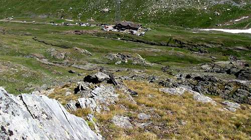
From Sogno di Berdzè Refuge (2.526m): here you can see the end of the Urtier Valley and, avoiding all the deviation on the right (Acque Rosse Valley, Miserino Lakes, Arietta Pass), you can arrive and rest at the Sogno di Berdzé hut (2.526m), if you have two days at your disposal. Vice versa go down towards the Alpe Broillot (2.396m) and, after the Alpe Pianas (2.406m), begin to follow the road in the direction of the starting from to the car parking of Lillaz (1.617m). Follow the path below upaved road, until reach Baite di Gollies. Move on until tiny church of Crêt, clearly visible from lowlands. Once gone beyond Tsavanis (2.296m) and Manda (2.370m) moutain pastures, the hut is reached in (3h'30/03h'45 from Lillaz). From refuge return West-southwest direction and by dirt road to at beginning of path n° 13, High Route n° 2, TVC, in quota 2.469m and from this by preceding approach B (E; 0h'15).
Dal Rifugio Sogno di Berdzè (2.526 m): dall'abitato di Cogne (1.534 m) in bus o in auto raggiungere la ridente frazione di Lillaz (1.617 m), dove si parcheggia l'auto nel grande piazzale sito quasi al centro del villaggio. Percorrere il sentiero al disotto della strada poderale fino alle Baite di Gollies (1.854 m), continuare fino alla Chiesetta di Crêt, ben visibile dal basso, e oltrepassati gli alpeggi di Tsavanis (2.296 m), Manda (2.370 m), il bivio 2.465 m, con un largo tornante dopo una fontana nella roccia si raggiunge il rifugio (E; 3h'30/3h'45 da Lillaz). Dal rifugio tornare indietro verso W-SW con la poderale sino a quota 2.469 m, ove si diparte il sentiero n° 13, Alta Via n° 2, TVC e, tramite questo, raggiungere il precedente Avvicinamento B (E; 0h'15).
Approach D
From fork 2.580m~ between Peradzà Bassa/Gratton Coastlines and Nouvas/Miserino Valleys: through preceding Approach A, B, C and from junction of paths n° 13/13B-13C go up by South direction passing the Peradzà Bassa and Gratton Coastline as far as the fork 2.580m~, under the quota 2.461m; from crossroads, leaving right (South-southwest) the path n° 13c towards Miserino Lakes, continue by left ramification or path n° 13B, VA (= of Aosta Valley Tour). Afterwards changing in South-southeast direction (rare yellow signs in existence), go up on grassy humps and rocky promontory, between Peradzà Bassa (Lower; in East) and Nouva Little Valley in right, coming contra the with same name point also head, in quota 2.850m~. From this point, abandon the "slender" track to East-southeast, crossed of Nouva Head the entire Northern Slope, and, by South direction, border completely the of same West Wall. Always through the very ancient mule-track, go up, by progressive more steep hairpins bend and with path less and less thick and more and more subject to landslips, up to contra its face (from this rocks falls danger); continue, through a large, inclined and rubble ledge, crossing of wall completely the base, by to Nouva Valley exposed great ribbings (much delicate hard snowfields extant). At last, by a below the face about thirty metres in descent traverse, reach the great boulder under the pass (niche in the shape of shelter and suitable for "salle à manger" (= food place), under the rocky cliff; by blue, polished and slippery rocks briefly to pass (2.947m; only above little bell, with tripod, for ring to Cogne and to Saint Besso Sanctuary in Piedmont. Famous procession inter two Valleys on August Holiday), goal of a lot ancient passages by Salasses (Aosta Valley Celtic People) and Romans (EE; EE/A snowfields extant; 1h'45/2h'00 from fork 2.580m~; 2h'30 from Broillot Pasture; 2h'15/2h'30 from Sogno di Berdzé Refuge; 4h'30/5h'00 from Lillaz Village).
Dal bivio 2.580 m~ tra le Coste Bassa di Peradzà/Gratton ed il Vallone Nouva/Miserino: con i precedenti avvicinamenti A, B e C e dalla congiunzione dei sentieri n° 13/13B-13C risalire con direzione S superando la Bassa di Peradzà e la Costa Gratton sino al bivio 2.580 m~, sottostante la quota 2.641 m; lasciando a destra (S-SW) il sentiero n° 13c per i Laghi del Miserino, continuare con la ramificazione di sinistra o sentiero n° 13B, VA (Tour de la Vallée d'Aoste). Cambiando progressivamente direzione in S-SE (rari segnali in color giallo), continuare, su dossi e promontori erbosi a cavallo tra la Bassa di Peradzà ad Est ed il piccolo Vallone della Nouva a destra, portandosi a ridosso dell'omonima punta o testa. Qui giunti ed in quota 2.850 m~ abbandonare l'esile traccia, che indirizzandosi ad E-SE attraversa l'intero Versante Settentrionale della Testa della Nouva, e, con direzione S, contornare l'intero Versante Occidentale della stessa. Sempre con l'antica mulattiera, guadagnare quota con tornanti più ripidi e con il sentiero che diviene sempre più franoso sin contro la sua parete (pericolo di caduta di pietre); proseguire sull'ampio cengione che ne taglia alla base l'intero versante, passando alcuni tratti esposti su costoloni rocciosi rivolti al Vallone della Nouva (molto delicato se con neve dura). Infine, con una discesa di una trentina di metri e di traverso alla base della parete, raggiungere il gran masso sottostante al colle (nicchia atta a ricovero ed a salle à manger sotto il salto roccioso); per rocce color blu, molto levigate e soprattutto scivolose se bagnate, raggiungere il Colle dell'Arietta (2.947 m; campana su treppiede appena sopra per suonare verso la Valle di Cogne e verso il Santuario di San Besso sul versante piemontese. Famosa processione tra le due vallate a Ferragosto), meta di antichissimi passaggi della popolazione valdostana dei Salassi e dei Romani (EE, con neve EE/A; 1h'45/2h'00 dal bivio 2.580 m~; 2h'30 dall'Alpe Broillot; 2h'15/2h'30 dal Rifugio Sogno di Berdzé; 4h'30/5h'00 da Lillaz).
Lower Variant (under of West Face plinth base and through Nouva Valley): by same previous route or Approach D as far as quota 2.700m~, where a small track direct one steps, by South direction, to little Nouva Valley. (*** moreover it's possible, starting from Broillot Pasture, crossing through a brief descent the Peradzà Torrent, go up by Southeast direction and path n° 13A reach the of trails intersection area in quota 2.440/50m~; from this point continue by path to Miserino Lakes joining in quota 2.580/90m~ the path n° 13C towards Miserino Pass (2.842m). Leaving right this last both (West-southwest and South-southwest), begin the ascent along a little torrent, passing under a great wall of Miserino Point (3.010m) N-NE Buttress. Advance into Nouva Valley and, through steep moraine or glacial-snowfields rejoin the preceding route). Entirely cross, briefly direction in South-southeast chancing, and through residual snowfields go up, under the plinth base (fitted to bear the of West Wall longitudinal great ledge; even in this case rocks fallings possibility) passing; also, for risky situation avoid, go up more in West and inside of the valley. Directly climb to pass (here always in sight, on contrary of previous route where in terminal part it's visible) reaching a rocky islet under the same. From this point finish by two chances:
a) - go up in vertical, by rotten rocks or snowfields at the beginning of season;
b) - keeping more in right and by analogous ascent, but hardly more easily, through a small and narrow in final part gully, easily exit out only over the pass (same times and same of preceding routes remarks).
Variante Bassa (sotto lo zoccolo basale della Parete Ovest ed attraverso il Vallone della Nouva): con lo stesso percorso precedente o Approach D sino a quota 2.700 m~, ove una piccola traccia si indirizza, con direzione S, nel piccolo Vallone della Nouva. (*** é possibile anche, partendo dall'Alpe Broillot, attraversando tramite breve discesa il Torrente di Peradzà, con il sentiero n° 13A verso SE raggiungere l'intersecazione dei varii sentieri a quota 2.440/50 m~; da questo punto continuare con il sentiero per i Laghi di Miserino sino a quota 2.580/90 m~ incontrando il sentiero n° 13C per il Colle Miserino (2.842 m). Lasciando questi due ultimi a destra (W-SW e S-SW), iniziare la salita lungo un piccolo torrente passando al di sotto della grande parete terminale del Contrafforte N-NE della Punta del Miserino (3.010 m) inoltrandosi nel Vallone della Nouva. Risalire attraverso la ripida morena o per mezzo di glacio-nevati ricongiungendosi alla stessa via). Percorrerlo interamente cambiando leggermente e progressivamente direzione in S-SE e per nevati residui risalirlo, passando sotto lo zoccolo roccioso atto a sostenere la grande cengia traversa della Parete O (anche in questo caso pericolo di caduta di pietre, anche se ci si può tenere maggiormente a destra (Ovest) nella salita all'interno del vallone). Puntando direttamente al colle (qui sempre ben in vista, mentre con il precedente itinerario appare solo all'ultimo) raggiungere l'isolotto roccioso sottostante il medesimo; da questo punto finire con due possibilità:
a) - risalire appena a sinistra della verticale al passo per nevati in inizio stagione, oppure su rocce rotte;
b) - tenersi più a destra con salita pressoché identica ma leggermente più facile e, tramite uno stretto e facile canalino nella parte terminale, uscire appena sopra al colle medesimo (stessi tempi e stesse considerazioni di Approach D).
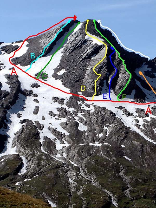
Main ascent routes: A, B, C, D, E, F
Route A (E-NE Crest or Standard Route): from fork 2.468m near Nouva Torrent go up before North-northeast, after North by path n° 13b/13C contra and below the quota 2.530m, nearby various little torrents, descending from Gratton Coastline, and over a tiny lake; here Southwest cross the torrent and, by two large hairpin winding, from Peradzà Bassa (= Low Promontory) to Gratton Coastline. Leaving below the quota 2.641m the deviation (path n° 13C to Southwest) towards Miserino Valley and splendid Lakes, go up, South-southeast direction, by a splendid and very ancient mule-track towards Arietta Pass (2.947m); abandon even this in quota 2.800/50m~ and, no obliged route (traces on soil), doubling East the N-NW Buttress, from Nouva Head descending. Cross the whole Northern Slope, by a small debris trace in diagonal East-southeast ascent, reaching the large Saddle 2.963m. From this climb by E-NE Ridge, non always easily and with exposition before in North (Urtier), after in South (Campiglia Soana); after a plate with gravels and leaning to the North (I°+/II°-, delicate snow extant) continue in edge with same difficulty. Crossing East Ante-summit (3.010m~), South doubling by a grassy and bad rocky ledge (II°-, exposed and~ delicate passage) and through a more easy rocks to aerial Summit (EE/A;~) 1h'30/2h'00 from crossroads 2.468m).
(Cresta E-NE o Via Normale): dall'incrocio 2.468 m presso il Torrente de la Nouva salire verso N-NE prima e N dopo con il sentiero n° 13B/13C sin sotto la quota 2.530 m presso numerosi torrentelli provenienti dalla Cote Gratton ed un piccolo laghetto dabbasso; qui attraversare verso SW il torrente portandosi con due larghi tornanti dalla Bassa di Peradzà alla soprastante Cote Gratton. Abbandonata sotto la quota 2.641 m la deviazione (sentiero n° 13C verso SW) per il Vallone ed i bei laghi del Misurino, risalire verso S-SE con la splendida ed antichissima mulattiera del Colle dell'Arietta (2.947 m); lasciare anche questa a quota 2.800/50m~ e, senza percorso obbligato (tracce) doppiare verso sinistra (E) il costolone N-NW che scende dalla Tete de la Nouva. Tagliare su di una piccola traccia tra detriti con salita diagonale verso E-SE tutto il Versante Settentrionale raggiungendo la larga Sella 2.963 m Da questa percorrere la Cresta E-NE non sempre facile ed esposta nel primo tratto a N (Urtier) e nel secondo a S (Campiglia Soana); dopo una placca iniziale con ghiaie ed inclinata a N (I°+/II°-, delicata se con neve) continuare sul filo di cresta (I°+/II°-). Oltrepassata l'Anticima E 3.010 m~, doppiandola a S, per una cengia erbosa e roccia friabile (II°-, esposto e delicato) e rocce più semplici raggiungere l'aerea Vetta (EE/A; 1h'30/2h'00 dal bivio 2.468 m).
Route B (N-NE Edge): by Approach A and along diagonal route with traces to Saddle 2.963m, almost below the same; abandon, through South direction, the small path under the vertical ascent of clear NE Edge, dividing in two parts the Northern Slope of mountain. Go up before through a debris little cone at of edge base, in quota 2.910/20m~. Start by a grayish rocks and climb nearly in edge (between the triangular NE Wall, red plates formed, and the large snowy plateau descending from the two Summits) avoiding a more difficult obstacles immediately left (East; II°+/III°-/ short parts III°+). Still go up in edge by discontinuous difficult, passing in progression six ledges (the third inclined in Northwest), reaching a seventh more enlarged, double and by round-polished rocks formed, in the shape of two cliff with double beak. The same present in right, through rubbles, debris and broken rocks, an escape route to South-southeast on of E-NE Crest terminal part, or standard route. Overcome the of edge (here most large and much round, consisting of more easy but more rotten rocks) final part and exit out near the stoneman of Antesummit East (3.010/15m~; PD+/AD+; difference in level 100/10~ meters; length 140/50m~; 2h'00/2h'30).
(Spigolo N-NE): con l'avvicinamento A lungo il diagonale verso la Sella 2.963 m, sin quasi sotto la stessa; abbandonare la traccia e rivolgersi, con direzione S, al netto Spigolo NE, che divide in due il Versante Settentrionale della montagna. Iniziare la salita a quota 2.910/20 m~ su placche grigiastre mantenendosi sul filo (divisorio tra la triangolare Parete NE, formata da placche rosse ed il largo canalone nevoso proveniente dalle due cime), aggirando alcuni passaggi più impegnativi subito a sinistra (E; II°+/III°-/ brevi tratti di III°+). Continuare sempre sullo spigolo, con passaggi di difficoltà discontinua, superando progressivamente sei cenge (la terza inclinata a NW), e raggiungendone una settima molto più estesa, doppia e formata da rocce arrotondate e levigate, sporgenti a forma di due tetti con doppio rostro. La stessa consente una via di fuga a S-SE, permettendo, tramite rottami e detriti, di poter raggiungere la Cresta E-NE, o via normale, nell'ultimo tratto. Vincere la parte finale dello spigolo, qui ben più largo e composto da rocce più facili ma anche più rotte, uscendo vicino all'ometto dell'Antecima Est (3.010/15 m~; PD+/AD; dislivello 100/10 m~; lunghezza della via 140/50 m~; 2h'00/2h'30).
Route C (Northern Couloir into the North Face): the diagonal crossing of the Normal Route, just before you reach the Northeast Edge rounding the same, steep climb to South in the direction of the slope, usually snow-covered throughout the year, covering the North Slope. This is the same between the edge and the large Rib North-northwest and salt with slopes cha vary from 30°/35° to the base but which gradually increase in gradient; when the same, at about half of its path, becoming a couloir narrows considerably increase the slopes reaching even to 40°/45° and even more in the final stretch, where it terminates between the Summit and the rounded Western Ante Top (3.025m~). Can be used for a more rapid descent but, in this case, requires good snow conditions (typically transformed, not too hard and with the absence of ice); provide a fun climb training of 140/50 meters~ (from F to + PD-/PD+; 1h'15/1h'30 from the base).
(Per il pendio-canale della Faccia Nord): nella traversata diagonale della Via Normale, poco prima di raggiungere lo Spigolo Nordest doppiando lo stesso, salire decisamente verso Mezzogiorno in direzione del pendio, generalmente innevato per tutto l'anno, che ricopre il Versante Settentrionale. Questo é compreso tra lo spigolo medesimo ed il Costolone Nord-nordovest e sale con pendenze varianti da 30°/30° alla base ma che progressivamente aumentano in pendenza; quando lo stesso, a circa metà del suo percorso, si restringe diventando un canale le stesse aumentano notevolmente arrivando anche a 40°/45° ed anche di più nel tratto finale, dove termina tra la Sommità e la arrotondata Ante Cima Ovest (3.025 m~). Può essere utilizzato per una più rapida discesa ma, in questo caso, richiede buone condizioni di neve (in genere trasformata, non troppo dura e con assenza di ghiaccio); prevedere una divertente salita di allenamento di 140/50 metri~ (da F+ a PD-/PD+; 1h'15/1h'30 dalla base).
Route D (N-NW Pillar also Winding Ribbing): always by Approach A as far as with division D (to Arietta Pass) and along diagonal route with traces to Saddle 2.963m up to quota 2.875m~ doubling left the massive base of Great Crest W-NW and a following more small winding ribbing, descending from same. Abandon, through South direction, the traces by a little path at base in quota 2.875m~, and begin on large and round Pillar/Great Winding N-NW. By a brief diagonal left (East) ascent, with steep but rotten rocks, reach a first earthy ledge; from this point turn right, after by of edge vertical ascent and non difficult rocks, but with soil, reach a second more large saddle. Climb by about dozen metres moving to the right on true edge; "ticklish" climb by a detached rocky blades, with smooth surface inclined to Northeast (no let one-self go to the same, in the shape of tile roof, because unsafe; on Summer 2003, during the First Ascent, a group climbers without rope in ascent and in descent, destitute of means). Reach a steep brownish wall and following a third higher ledge; from this, by steep but easy rocks, finish on round shoulder of Great W-NW Crest, whence through debris and broken rocks to West Summit (3.025m~; AD-; 1h'00/1h'30).
(Per il Pilastro o Costolone N-NW): sempre con l'avvicinamento A sino allo sdoppiamento con D (per il Colle dell'Arietta), voltando ad E a quota 2.850 m~; oltrepassare verso sinistra la base massiccia del Crestone W-NW ed una successiva e di minori dimensioni costola sinuosa, scendente dallo stesso. Con un sentierino, che ne attraversa le rocce proprio alla base a quota 2.875 m~, portarsi all'attacco del largo ed arrotondato Pilastro/Costolone N-NW, sito tra due canaloni nevosi provenienti da uno spallone del Crestone W-NW. Iniziare con una breve salita diagonale verso sinistra (E) e, con rocce ripide ma rotte, raggiungere una prima terrazza terrosa; qui voltare a destra andando ad afferrare il filo dello spigolo. Con rocce non difficili, ma ricoperte da terriccio, raggiungere una seconda e ben più larga cengia; risalirla per una dozzina di metri portandosi sul vero e proprio spigolo. Progredire su lame staccate con lisce placche inclinate verso NE (non lasciarsi attrarre dalle stesse a forma di tetto di tegole, perché pericolosamente distaccate una dall'altra) e, con arrampicata delicata (nell'estate del 2003, durante la prima ascensione, salita e discesa della via senza corda, essendone la cordata sprovvista) portarsi contro un ripido muro di rocce brunastre adducenti alla terza e superiore cengia. Da questa, con passaggi ripidi ma più facili, uscire sul rotondeggiante spallone della Cresta W-NW, donde per detriti e blocchi rotti alla Vetta Ovest (3.025 m~; AD-; 1h'00/1h'30).
Route E (W-NW Ridge from the junction Nouva Vallon/Bassa di Peradzà): from the path n° 13B, VA (Tour de la Vall & eacute; e d'Aoste) turning East at an altitude of 2,880/5 m ~, pass to the left the massive base of "Crestone" W-NW and a subsequent, smaller, sinuous rib, descending from it. With a slender and discontinuous trace of the path, which crosses the rocks right at the base at an altitude of 2.890/5m~, reach the start of the broad and rounded "Crestone" W-NW, located immediately S -SO of the previous route or "Costolone " N-NW. Start with a short diagonal and sinuous climb to the left-right-left-right (E/W, E/O) and, with steep but fairly broken rocks, reach a first rounded rocky hump (II°/ II°+/III°-); here go to the left going to grab the edge of the ridge from this point in the shape of an edge. With rocks that are not difficult, but covered with flakes and soil, reach a second stretch formed by a series of small roughnesses; go up it for about fifteen meters reaching the real edge that forms four rocky jumps in succession, the latter of which "merges" with a secondary branch that comes from more to the North (You can attack from this too, starting on some brown-greyish plates that plunge to the left into a snowy / detrital gully that immediately descends alongside the N-NW Rib; II°/II°+ and a short section of III°-. After this start, the small ridge-edge softens and is made up of easier rocks (II°-) but also more broken) and which ends its existence here (from the II°+ at the III°+ with two short passages of the IV°- in the last two small walls). Beyond the ridge it loses importance and progressively decreases the difficulties, while always remaining a good exposure on the Southern Slope, where the SW Wall diminishes. Bending slightly to the left (E) you reach the hanging-perennial snowfield snowfield, located below the Southwestern Summit as well as at the end of the Pillar or "Costolone" N-NW; after passing it on the right in a short time you reach the "Vetta" of the Southwestern Summit (3.025 m~; PD+/AD-; difference in level 135m~; 1h'00/1h'15).
(Per la Cresta W-NW dalla congiunzione del Vallone della Nouva con la Bassa di Peradzà): dal sentiero n° 13B, VA (Tour de la Vallée d'Aoste) svoltando decisamente ad Oriente a quota 2.880/5 m~, oltrepassare verso sinistra la base massiccia del Crestone W-NW ed una successiva, e di minori dimensioni, costola sinuosa, scendente dallo stesso. Con un'esile e discontinua traccia di sentiero, che ne attraversa le rocce proprio alla base a quota 2.890/5 m~, portarsi all'attacco del largo ed arrotondato Crestone W-NW, sito subito a S-SO della via precedente o Costolone N-NW. Iniziare con una breve salita diagonale e sinuosa verso sinistra-destra-sinistra-destra (E/O, E,O) e, con rocce ripide ma abbastanza rotte, raggiungere una prima gobba rocciosa arrotondata (II°/II°+/III°-); qui indirizzarsi verso sinistra andando ad afferrare il filo del crestone da questo punto a forma di spigolo. Con rocce non difficili, ma ricoperte da scaglie e da terriccio, raggiungere una secondo tratto formato da una serie di piccole asperità poste in rapida progressione; risalirla per una quindicina di metri portandosi sul vero e proprio spigolo che forma quattro salti rocciosi in successione, l'utimo dei quali va a "fondersi" con un ramo secondario proveniente da più a Settentrione (si può attaccare anche da questo, iniziando su delle placche bruno-grigiastre che si immergono verso sinistra in un canalone nevoso/detritico che scende subito a fianco del Costolone N-NO; II°/II°+ ed un breve tratto di III°-. Dopo questo avvio, la piccola cresta-spigolo si addolcisce ed é formata da rocce più facili (II°-) ma anche più spezzate) e che qui termina la sua esistenza (dal II°+ al III°+ con due brevi passaggi di IV°- negli ultimi due muretti). Oltre la cresta perde importanza e diminuiscono progressivamente le difficoltà, pur rimanendo sempre una buona esposizione sul Versante Meridionale, dove scema la Parete SO. Flettendo leggermente a sinistra (E) si raggiunge il nevaio pensile-perenne, collocato al di sotto della Sommità Orientale nonché al termine del Pilastro o Costolone N-NW; oltrepassato sulla destra il medesimo in breve si raggiunge la Vetta della Sommità Sudoccidentale (3.025 m~; PD+/AD-; dislivello 135 m~; 1h'00/1h'15).
VARIANT (Starting on the left or East secondary branch ): you can begin, starting on some brown-greyish plates that plunge to the left into a snowy / detrital gully that immediately descends alongside the N-NW Rib; II°/II°+ and a short section of III°-. After this start, the small ridge-edge softens and is made up of easier rocks (II°-) but also more broken and rotten to then enter to the right on the main branch.
VARIANTE (Attaccando più a sinistra od Est sul ramo secondario):iniziando su placche bruno-grigiastre che si immergono verso sinistra in un canalone nevoso/detritico che scende subito affianco del Costolone N-NO; II°/II°+ ed un breve tratto di III°-. Dopo questo avvio, la piccola cresta-spigolo si addolcisce ed é formata da rocce più facili (II°-) ma anche più rotte e spezzate per poi inserirsi verso estra sul ramo principale.
Route F (SW Ridge from Arietta Pass): from Arietta Pass (2.947m), reached through the Approach D also by Lower Variant, ascent start doubling right (Southeast) the first rocky bands and continue on edge or generally as soon as possible in right; go up by the same, almost in integral climb and with up both sides exposition, overcoming a few short walls not much easy but however surrounded through both sides. Reach the West Summit and from this, by short traverse, easily to Mayor Summit (PD+; difference in level 87m~; of the route search required capacity; 0h'45-1h'00).
(Per la Cresta SW dal Colle dell'Arietta): dal colle (2.947 m), raggiunto con l'avvicinamento D o con la Variante Bassa, inziare la salita doppiando a destra (SE) le prime ripide rocce e portandosi sul filo di cresta; risalire la stessa, quasi integralmente, incontrando alcuni "muretti" non facili e comunque contornabili su di uno o l'atro versante, dei quali il primo sulla destra (SE) ed in generale, laddove possibile, sempre sulla destra. Raggiungere la Cima Ovest e da questa, tramite breve e facile traversata, la Vetta più elevata (PD+; dislivello 87 m~; richiede capacità di scelta della via; 0h'45/1h'00).
VARIANT (Under SW Crest and by W-SW Slope): it's possible climb of the edge more in West, by some debris small couloirs, with more and more friable rock, into W-SW Slope (Felice Bechon and Company, in descent, on Summer 2004, for of route exploration); even in this instance same previous remarks and considerations.
VARIANTE (Sottostante la Cresta SW ed appoggiandosi sul Versante W-SW): é possibile tenersi più ad O del filo di cresta, sfruttando alcuni canalini detritici con roccia alquanto friabile del Versante W-SW; così Felice Bechon e compagno, in discesa, nell'estate del 2004 con l'intento di esplorare la via. Comunque, anche in questo caso, valgono le osservazioni e le considerazioni precedenti.
Difficulties
This route can be considered EEA/AD+.
L'itinerario è classificato EEA/AD+.
Equipment
Standard mountaineering equipment.
Campings
There are plenty of camping sites along the Gran Paradiso valleys. Remember that free camping is forbidden (except for emergency reasons, over 2.500m, from darkness until dawn).
"Guida dei Monti d'Italia–Emilius Rosa dei Banchi Parco del Mont Avic" di Giulio Berutto e Lino Fornelli-Club Alpino Italiano/Touring Club Italiano, Marzo 2005 (in Italian).
"I Rifugi della Valle d'Aosta" di Stefano Ardito, Ed. Guide iter, Febbraio 2003.
"Diari Alpinistici" di Osvaldo Cardellina e Indice Generale accompagnato da Schedario Relazioni Ascensioni 1964-2019 (inediti).
MAPS:
Enrico Editore Ivrea-Aosta "Gruppo del Gran Paradiso" 1:50.000.
L'Escursionista "Valle di Cogne Carta dei Sentieri" 1:25.000.
Parents refers to a larger category under which an object falls. For example, theAconcagua mountain page has the 'Aconcagua Group' and the 'Seven Summits' asparents and is a parent itself to many routes, photos, and Trip Reports.

 6871 Hits
 86.85% Score
 23 Votes