


-
 2650 Hits
-
 81.18% Score
-
 13 Votes
|
|
Mountain/Rock |
|---|---|
|
|
45.66240°N / 7.33746°E |
|
|
Hiking, Mountaineering |
|
|
Spring, Summer, Fall, Winter |
|
|
9744 ft / 2970 m |
|
|
Note
La montagna chiama i suoi figli, ed essi rispondono fedelmente al suo appello… Osvaldo Cardellina, Diario alpinistico, 1964-65 Page texts: @ OsvaldoCardellina "Osva", passed away on May 2, 2022. Page owners: Christian Cardellina e Osvaldo Cardellina. Any updates from September 12, 2022: Antonio Giani, page administrator, friend and climbing companion. Testi della pagina: @ OsvaldoCardellina "Osva", scomparso il 2 maggio 2022. Proprietari pagina: Christian Cardellina e Osvaldo Cardellina. Eventuali aggiornamenti dal 12 settembre 2022: Antonio Giani, amministratore della pagina, amico e compagno di salite. |
Beautiful Face Overview
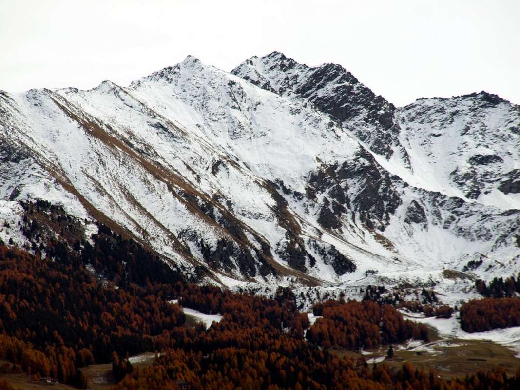
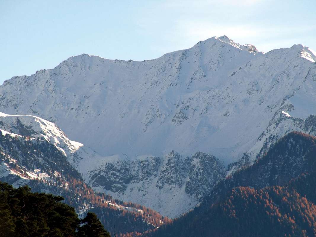
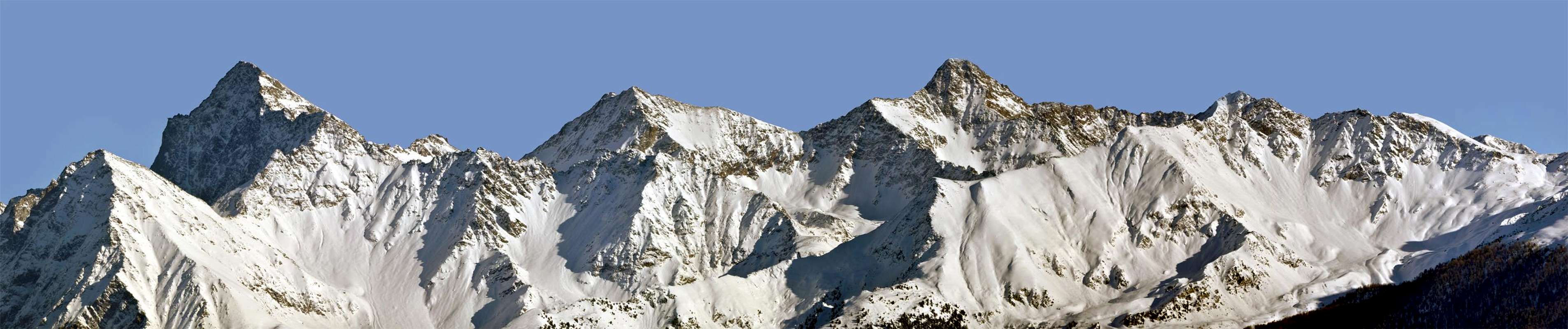
This Summit is a node topographic of secondary importance. In fact, although it does have a fairly high altitude (2.970m) "disappear" from the greater bulk of the nearby Punta della Valletta (3.090m), real heart, even if only slightly higher, at the edge of this small coastal Southwest Group of Monte Emilius (3.559m). This tiny subgroup, apparently on its own, originates from Colle Garin (2.815m), located between the Towns of Cogne Charvensod, and gets up to Punta Pian Bessey (3.085m) before reaching that of Valletta, the vertex of all this small mountain range. From this a ridge Westward first reach the Great Shoulder 3.207 meters and then the Col de Tsa Sètze with exactly the same height of the "Bassa di Garin or Low Garin" as it was once called this hill; then he proceeds to the Northwest with a series of modest elevations average of just over 2.650 meters to finish with the Punta de la Pierre above the small Village of Ozein, now in the Municipality of Aymavilles. A third ridge then descends towards the North reaching the Mont Bellefaçe and Testa Nera (Black Head; 2.970m, 2.820m), where it ends above the Chamolé Lake (2.325m) near the upper arrival of the homonym chairlift (2.311m). This watershed, dividing between the Commons of Gressan (West) and Charvensod (East), along with the previous contains the entire Basin of Pila, famous for attendance at ski resorts. So Mount Bellefaçe ranks in an intermediate position above this last, forming a transit point obliged to climb to Punta della Valletta with all ways from the North. Topographically has only two sides: the Eastern, addressed the Vallon of Arbolle, sloping down to the Lake of the same name and Refuge (2.496m, 2.516m), while to the West is a wide side that split in two by a ridge that descends with grassy-rocky path semicircular towards Northwest, able to separate the lower basin of the Plan de Eyve from that just above of Tsa Sètze. So a Summit as passage as well as, with other dimensions, for the Dôme du Goûter in the ascent with traverse towards the Mont Blanc or for a whole series of other with the same characteristics. It is rarely goal in itself, while it can become a point of arrival with snow very pronounced or in case of occurrence of true bad weather.
For this reason many hikers avoid it through a little path that "cuts" its Peak (small wooden sign with written) about thirty metres below on the West side, following what has been defined as "Via degli Alpini" equipped in its surroundings with fixed ropes, however unnecessary and almost completely disappeared or removed. Even the first winter ascent was carried out with this logic in 1977, while the first mention of this mountain is made with the name of Bella Faça (Beautiful Face) by the Abbot Joseph-Marie Henry in an article-monograph in the "Rivista Mensile" or Monthly magazine of the Mountain of the C.A.I. (1903, pages 73/8). It can be easily climbed with route on the ridges or directly from the Eastern Slope and then the Refuge Arbolle, avoiding the larger circle to the Chamolé Pass and the Black Head (2.641m, 2.820m), through rocks and residual snowfields; but is better to avoid the routes not difficult from the West due to steep grassy slopes interspersed with weathered rock. The crossings on crest from Testa Nera or Valletta are fun, safe and very panoramic with views from West to East about 220° on the circle of Graian and Pennine, while in the South are admirable only Grivola Grand Nomenon in the Gran Paradiso, hidden by the mass of Punta Valletta. Also splendid views of the nearby Group of Mont Emilius and the whole and underlying Pila Basin and Central Baltea Valley.
![]()
![]()
![]()
Approaches by Pila, Arbolle & Comboé
 |
 |
 |
 |
 |
Questa Sommità costituisce un nodo topografico di secondaria importanza. Infatti, anche se presenta una abbastanza notevole altitudine (2.970 m) "scompare" dalla maggiore mole della vicina Punta della Valletta (3.090 m), vero punto centrale, anche se di poco più elevata, di questa piccola costiera al margine Sudoccidentale del Gruppo del Monte Emilius (3.559 m). Questo minuscolo Sottogruppo, apparentemente a sé stante, prende origine dal Colle Garin (2.815 m), posto tra i Comuni di Cogne e Charvensod, e si rialza all Punta di Pian Bessey (3.085 m) prima di raggiungere quella della Valletta, culmine di tutta questa piccola catena montuosa. Da questa una cresta verso Occidente raggiunge dapprima lo Spallone 3.207 metri e quindi il Colle di Tsa Sètze con la stessa identica altezza della "Bassa di Garin", come veniva anticamente chiamato questo colle; poi procede verso Nordovest con tutta una serie di modeste elevazioni alla media di poco più di 2.650 metri per terminare con la Punta de la Pierre sopra il Villaggio di Ozein, ormai nel Comune di Aymavilles. Una terza cresta scende infine verso Settentrione raggiungendo il Mont Bellefaçe e la Testa Nera (2.970 m, 2.820 m), dove termina al di sopra del Lago di Chamolé (2.325 m) presso l'arrivo superiore dell'omonima seggiovia. Questo spartiacque, divisorio tra i Comuni di Gressan (Ovest) e Charvensod, insieme al precedente contiene l'intero Bacino di Pila, famoso per la frequentazione degli impianti sciistici. Quindi il Mont Bellefaçe si colloca in una posizione intermedia sopra questo ultimo, costituendo punto di transito obbligato per salire alla Punta della Valletta con qualsiasi via da Nord. Topograficamente presenta solo due versanti: quello Orientale, rivolto al Vallone di Arbolle, che scende fino agli omonimi Lago e Rifugio (2.496 m, 2.516 m), mentre verso Occidente un largo versante viene diviso in due da una cresta erboso-rocciosa che scende con percorso semicircolare verso Nordovest, atta a separare il più basso bacino di Plan de l'Eyve dal soprastante di Tsa Sètze. Quindi una Cima di passaggio come, con ben altre dimensioni, per il Dôme du Goûter nella salita al Monte Bianco o per tutta una serie di altre con le medesime caratteristiche. Infatti raramente costituisce meta a sé stante, mentre può diventare punto di arrivo con innevamento molto pronunciato oppure in caso di sopraggiungere di vero e proprio maltempo. Per questo motivo molti escursionisti lo evitano seguendo un piccolo sentiero che "taglia" la sua Vetta (piccolo segnale in legno con scritta) una trentina di metri al di sotto sul fianco Ovest, seguendo quella che é stata definita come "Via degli Alpini", attrezzata nei suoi dintorni con corde fisse peraltro inutili e quasi del tutto scomparse od asportate. Anche la prima ascensione invernale é stata effettata con questa logica nel 1977, mentre la prima citazione di questa montagna viene effettuata con il toponimo di Bella Faça dall'Abbé Joseph Marie Henry in un articolo-monografia sulla "Rivista Mensile" della Montagna del C.A.I. (1903, pagine 73/8). Può essere facilmente salito con percorso in cresta oppure direttamente dal Versante Orientale e quindi dal Rifugio di Arbolle, evitando così il giro più largo verso il Colle di Chamolé e la Testa Nera (2.641 m, 2.820 m), tramite npiose pietraie o residui di nevati; non difficili ma da evitare i percorsi da Ovest a causa di ripidi pendii erbosi alternati a rocce disgregate e mai buone. Le traversate in cresta dalla Testa Nera o dalla Valletta sono invece divertenti, sicure e molto panoramiche con vedute da Ovest ad Est di circa 220° sulla cerchia delle Alpi Graie e Pennine, mentre a Mezzogiorno sono ammirabili soltanto La Grivola e Grand Nomenon nel Gruppo del Gran Paradiso, occultato dalla massa della Punta della Valletta. Inoltre splendidi scorci sul vicino Gruppo dell'Emilius e sull'intera nonché sottostante Conca di Pila.
First Ascents
- First on the Summit: Unknown.
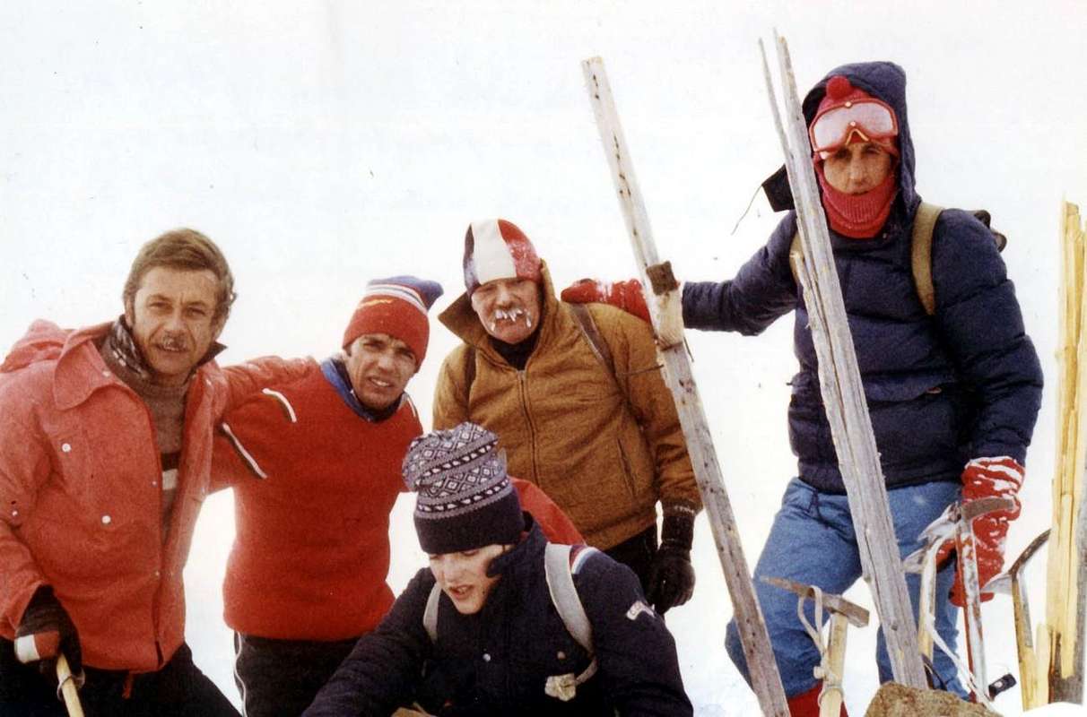
- First in Winter: Osvaldo Cardellina, Corrado Covi, Edy Covi, Camillo Roberto Ferronato, Giuseppe Lamazzi and Armando Poli, (Dec 30th, 1977).
- Northern Crest (Standard Route from Testa Nera): Unknown.
- Southern Crest (Standard Route from Punta della Valletta): Unknown.
- NW Ridge: Osvaldo, Christian and Alessandro Cardellina, (July 08th, 1990), in descent.
Getting There
BY CAR:
- From TORINO, MILANO, etc: Motorway A5. Exit at IVREA or Quincinetto (PIEDMONT).
- From IVREA Town: Charvensod, Gressan, Jovençan, Aymavilles Municipalities.From Charvensod (main road from Pont Suaz 567m) or by Gressan (603m; alternative road) to Tivet, Les Fleurs Hamlets (1.292m, 1.414m) Pila Basin and Resort (low parking nearby Cableway 1.800m; upper parking 1.850m). Arno Shelter (2.660m), always open but unguarded, nearby Couiss Summit on watershed Pila/Cogne Valley. From Jovençan (631m) to Western Pila Conca, exclusively through path-muletrack to Tourlin Dessous (1.466m) and by dirt road to Pila-Posse Tennis (1.776m). From Aymavilles (646m) to Western Pila Conca, through Main Road to Cogne Valley, alternative road to Ozein/Turlin Dessus Hamlets and dirt road to Pila-Posse.
- From FRANCE: through the Mont Blanc Tunnel to Entrèves-crossroads to Vény/Ferret Valleys - Mountain Guides of Courmayeur - La Saxe Rock Gym - Courmayeur. By Little Saint Bernard Pass, closed since November until half May to La Thuile Valley - Pré Saint Didier - Courmayeur. It is not necessary to take Motorway A5: you can drive on SS.26, in the direction of AOSTA - IVREA - TURIN.
BY PLANE:
- Aeroporto "Corrado Gex" Saint Christophe (Aosta).
Approaches & Routes
 |
 |
 |
 |
 |
A) - From Pila Resort through Chamolé Pasture and Plan Fenêtre Hill: (2.325m) on foot through the various paths n° 19/19A/19B, passing respectively to the Chamolé Pasture (2.532m; fountain), also towards the Bois de Chanté, going up directly into a small vallon towards Chamolé Lake (2.325m). Or by a chairlift, and the homonymous pass above (2.641m) and under Testa Nera or Auille Nera (2.819/20m). Wherefrom the Normal Route to the Testa Nera (Northeast Crest) and following Mont Bellefaçe (Northern Ridge) starts also from the ones arriving here from Arbolle Vallon.
B) - From Arbolle Refuge and by the above Chamolé Pass: from the new shelter built in the biennium 1996-1997 and inaugurated in July 1998 (2.516m, even reachable from the Cogne Valley starting from Gimillan Village (1.787m) through the Arpisson Vallon, the Bivouac Franco Nebbia (2.741m) and the Garin Hill or the ancient "Bassa de Garin" (2.815m) through the paths n° 2 and down in the Arbolle Vallon through the trail n° 18) ford the torrent in a small cove at the old barn and started to go up with large bends between grassy slopes through path n° 18/TVC; with a diagonal progressively to the North under Testa Nera and a steep section at the terminal easily and quickly you get to Chamolé, whence the Northeast Crest (T/E; 0h'30).
C) - From the Vallon of Comboé passing on Arbolle Gorge: from Comboé Alp and Sant'Orso private Refuge with adjacent tiny Chapel (2.114m; private retreat with property of the Canons of Saint Orso in Aosta), reachable by Ponteilles Alp (1.697m) or from Pila-Resort via the Plan Fenêtre Hill (2.221m) you can reach the Chamolé Hill (2.641m) with two other possibilities:
1) - immediately behind the shelter apart from the steep path n° 19 rather than through hairpin bends to reach the North Col Replan (2.366m); from this a wider path down to the Southwest towards Lake Chamolé (2.325m; yellow signs and panels) where you reconnect with the previous Approach A)-.
2) - it is also possible to reach the Refuge Arbolle (2.516m) with a larger circle to the South that, after reaching the Alp derelict Grand Plan (2.158m), crosses the Torrent de Comboé with a diagonal from right to left in the middle of a step heap of stones below a rocky promontory; the route n° 16 at this point enters a narrow gorge with very tight bends reaches him, hence the Approach B) - (both EE/F+; 1h'30/1h'45 to the hill).
Avvicinamenti da Pila, Arbolle & Comboé
 |
 |
 |
 |
 |
A) - Dal Comprensorio di Pila attraverso l'Alpe di Chamolé ed il Colle Plan Fenêtre: Da Pila (nota località sciistica, raggiungibile da Aosta in auto pullman oppure tramite la funivia), raggiungere il Lago di Chamolé (2.325 m, anche qui in seggiovia o a piedi tramite i vari sentieri n° 19/19A/19B) che passano rispettivamente per l'Alpe di Chamolé (2.532 m; fontana), oppure attraverso il Bois de Chanté, salendo direttamente tramite un valloncello al Lago di Chamolé (2.325 m) e l'omonimo colle superiore (2.641 m) al di sotto della Testa Nera od Auille Nera (2.819/20; dalla "Carta dello Stato Maggiore Sardo" del 1852). Da qui inizia la Via Normale verso la Testa Nera (Cresta e Versante Nordest) ed il successivo Mont Bellefaçe (Cresta Nord) anche per chi perviene dal Vallone d'Arbolle.
B) - Dal Rifugio di Arbolle ed il soprastante Colle di Chamolé: dal nuovo rifugio costruito nel biennio 1996-1997 ed inaugurato nel Luglio del 1998 (2.516 m; raggiungibile anche dalla Valle di Cogne con partenza verso Nordovest dal Villaggio di Gimillan (1.787 m) tramite il Vallone di Arpisson, il Bivacco Franco Nebbia (2.741 m) ed il Colle Garin anticamente chiamato e conosciuto quale "Bassa de Garin" (2.815 m) tramite i sentieri n° 2 ed in discesa nel Vallone di Arbolle n° 18) guadare il torrente in una piccola ansa presso la vecchia stalla dei manzi ed iniziare a salite con larghi tornanti tra pendii prativi tramite il sentiero-mulattiera n° 18/TVC; con un lungo diagonale, progressivamente verso Settentrione ed un tratto più ripido ed esposto nella parte terminale sotto le pareti roccioso-erbose del Versante Orientale della Testa Nera, facilmente ed in breve tempo si arriva al Colle di Chamolé, donde alla Cresta Nordest (T/E; 0h'30).
C) - Dal Vallone di Comboé tramite la Gola d'Arbolle: dall'Alpe o Rifugio privato di Comboé con adiacente piccola e graziosa Cappella (2.114 m; proprietà dei Canonici di Sant'Orso in Aosta), raggiungibile dall'Alpe di Ponteilles (1.697 m) oppure da Pila tramite il Colle Plan Fenêtre (2.221 m) si può arrivare al Colle di Chamolé (2.641 m) tramite due altre possibilità:
1) - da subito dietro il rifugio parte il ripido sentiero n° 19 che, tramite alquanto stretti tornanti, raggiunge il Colle Settentrionale di Replan (2.366 m); da questo un sentiero più largo scende a Sudovest verso il Lago di Chamolé (2.325 m; pannelli con indicazioni in giallo) dove ci si riconnette col precedente Avvicinamento A)-.
2) - Inoltre é possibile raggiungere il Rifugio d'Arbolle con un giro più largo verso Sud che, dopo aver raggiunto l'Alpe diroccata di Grand Plan (2.158 m), attraversa il Torrent de Comboé con un diagonale da destra verso sinistra in mezzo ad una ripida pietraia; il sentiero n° 16 a questo punto entra in una strettoia-gola e con tornanti strettissimi lo raggiunge, donde all'Avvicinamento B)- (EE/F+; 1h'30/1h'45 al colle).
Standard Routes passing through Testa Nera
 |
 |
 |
 |
 |
Route A) - climb with "traditional route" through Chamolé Hill and the Northeast Crest and Northeast Slope: This is definitely the way followed by more and more, but still something extra after the construction of the Shelter Arbolle in July 1998. Starting with the arrival of the Chair lift (2.311m) to quickly reach a wide path through the slight slope Chamolé Lake (2.325m ; yellow signs); from the junction with the trail to the two Hills of Replan and Comboé Vallon climb down to the right (South) and with a long diagonal first, followed by numerous large hairpin bends, reach Chamolé Pass (2.641m; TE/F; 0h'50/1h'00), exposed to the East and real door entrance to the Vallon of Arbolle, lakes and shelter. Always a yellow sign points the way to the Tip of the Valletta (+ 3.090m) on the right; follow these directions and on a small track begin the ascent to below the edge of the Northeast Crest (this can be traversed in steps of I°/II°, exposed to Southeast) until the same, via a short crossing, is port more on the Northeast Slope. Go up broken rocks and debris and then with a few small steps on some narrow arrive on the same ridge where the trail becomes more evident with exposure from the same side; in short it out on the vast grassy plateau immediately to the left of the Cross of Summit (E/F; 0h'30; total 1h'30 from the start; 2h'45/3h'15 in total by Pila). From Black Head or Testa Nera (2.820m) continue to the South through a vast grassy plain with scattered rocks and blocks until you reach the small path 19B/Via dgli Alpini dating from the Northwest Side of the same; with this, flexing just right, get a band of rocks that you dub on the right and then back on the edge of the ridge coming to altitude 2.869 meters. Then, bending just to the left and below the same wire, you will reach a series of rocks and blocks stacked (I°) which lead under the Summit. A trail leads from the North and from the South to the Top (E/F; 0h'40 from Testa Nera; 4h'00 overall from Chamolé Upper Station; 5h'00 Pila).
Route B) - rise for the Northwest Slope ("Via degli Alpini") or through the Northwest Ridge: a second way, an alternative to route A)-, up along the Northwest Slope, just below the crest of the same, that goes on the left. Always starting from the Upper Station of Chair lift, climb directly to the South through a small and very steep path numbered 19B/"Alpini Via", which reaches a rocky headland forest-followed by a depression (2.450m); reach a second subsequent altitude (2.484m) neighbor an evident structure of the lifts of white color. From this point the trail, which is getting smaller and subsequently less obvious moves away from the ridge into the Northwest bringing more open slope until you reach a large grassy saddle South in respect to the Summit. With this and with the direction to the North in a short time you can reach the same (E/F; 1h'15/1h'30 from the Chamolé Upper Station; 3h'00/3h'15 from Pila Resort). Alternatively, if you want to climb, carry much of the property on the Northwest Edge of the ridge and follow the same steps with the possibility of changing to a plate blackish just just below the Top; go with fun climbing (III°/III°+), or around the same immediately below to South (A/F+ to AD-, according to the passages performed; 2h'00/ 2h'30 from the arrival of Station). In both cases, both the large grassy saddle that from the Summit rejoin the previous route (path 19B/Alpine Route) and with this conclusion.
Vie Normali attraversando la Testa Nera
 |
 |
 |
 |
 |
Via A) - con salita "tradizionale" tramite il Colle di Chamolé e la Cresta Nordest appoggiando sullo stesso versante: trattasi sicuramente della via maggiormente seguita da sempre, ma ancor più dopo la costruzione del Rifugio di Arbolle nel Luglio 1998. Partendo dall'arrivo della Seggiovia (2.311 m) raggiungere in breve tramite un largo sentiero in falsopiano il Lago di Chamolé (2.325 m; cartelli segnaletici gialli); dal bivio col sentiero per i Colli di Replan ed il Comboé salire invece a destra (Sud) e con un primo lungo diagonale, seguito da numerosi e larghi tornanti, raggiungere il Colle di Chamolé (2.641 m; TE/F; 0h'50/1h'00), vera porta d'ingresso per il Vallone di Arbolle, laghi e rifugio. Un cartello, sempre giallo, indica la via per la Punta della Valletta (+ 3.090 m) sulla destra; seguire queste indicazioni e su d'una piccola traccia iniziare la salita al di sotto del filo della cresta Nordest (questa può essere percorsa con passaggi di I°/II°, esposti a Sudest) fino a quando le stesse, tramite breve traversata, si portano maggiormente sul Versante Nordest. Salire per rocce rotte e detriti per poi con alcuni passaggetti su alcune strettoie arrivare sulla cresta medesima, ove lo stesso diviene più evidente con esposizione sempre identica; in breve si esce sul vasto plateau erboso subito a sinistra della Croce della Sommità (E/F; 0h'30; in totale 1h'30; complessivamente con partenza da Pila 2h'45/3h'15). Dalla Testa Nera (2.820 m) continuare a Sud attraversando un vasto plateau erboso con blocchi e rocce sparse sin incontrare il sentierino 19B/Via dgli Alpini che risale il Versante Nordovest della medesima; con questo, flettendo appena a destra, raggiungere una fascia di roccette che si doppiano sulla destra per poi tornare sul filo della cresta arrivando alla quota 2.869 metri. Quindi, ripiegando appena a sinistra e sotto il filo medesimo, si raggiunge una serie di rocce con blocchi accatastati (I°) conducenti sotto la Vetta. Una traccia sia dal Nord che da Sud porta alla Cima (E/F; 0h'40 dalla Testa Nera; 4h'00 in tutto; 5h'00 da Pila).
Via B) - con salita per il Versante Nordovest ("Via degli Alpini") oppure per la Cresta Nordovest: una seconda via, alternativa alla A)-, sale lungo il Versante Nordovest, subito al di sotto dell'identica cresta, che l'accompagna sulla sinistra. Sempre partendo dalla Stazione della Seggiovia, si sale direttamente verso Mezzogiorno tramite un piccolo ed alquanto ripido sentiero numerato 19B/"Via degli Alpini", raggiungente un promontorio boschivo-roccioso seguito da un avvallamento (2.450 m); arrivare ad un secondo in altitudine 2.484 m) presso una evidente struttura degli impianti da sci di colore bianco. Da questo punto il sentiero, che diventa sempre più piccolo ed in seguito meno evidente, s'allontana dalla Cresta Nordovest portandosi in più aperto pendio fino a raggiungere una vasta sella erbosa a Sud della Sommità. Tramite questo e con direzione a Nord in breve tempo si raggiunge la medesima (E/F; 1h'15/1h'30 dalla Stazione Superiore; 3h'00/3h'15 dal parcheggio di Pila). In alternativa, volendo arrampicare, dalla struttura portarsi decisamente verso sinistra e sul filo della Cresta Nordovest e seguire lo stesso con possibilità di variare i passaggi fino ad una placca nerastra appena subito sotto la Sommità; salire con divertente arrampicata (III°/III°+), oppure aggirare la medesima subito al di sotto a Sud (A/F+/AD-, a seconda dei passaggi eseguiti; 2h'00/2h'30 dall'arrivo della Seggiovia). In entrambi i casi sia dalla larga sella erbosa che dalla Testa Nera ricongiungersi all'itinerario precedente (sentiero 19B) e con questo concludere.
Normal Via from South crossing Punta della Valletta from Col Tsa Sètze or by Col Garin
 |
 |
 |
 |
 |
Route C) - with "tradizional" traverse from Punta della Valletta and through the South-southeast Ridge: typically this Summit is reached before continuing to Punta Valletta (3.090m) with a classic crossed from North to South and its return by the same route.
1) - But the Mont Bellefaçe can be reached by the same just with the return path and after the ascent via the West Ridge or "Via Ferrata" equipped since 2003 and nowadays quite popular. In this case completely changes the approach and by the Upper Station of the Chairlift or directly from Pila via different routes you have to reach the Plan de l'Eyvie Pastures (2.253m), on the slopes of the Mont Bellefaçe Western Slope and its Northwest Ridge. The trail 22 reaches the same and then continue above the valley leading to the Col Tsa Setze (2.815m), which takes the beginning of the "Ferrata".
2) - Also you can reach the Punta della Valletta also from Colle Garin (2.815m) starting either from Arbolle Refuge (2.516m) with the trail 14/18/TVC that from the Bivouac Franco Nebbia (2.741m) in Cogne Valley with the n° 2. From the hill climb to Punta di Pian Bessey (3.085m) via the Northeast Ridge or a small track, not always evident, below the ridge to the North and by this easily navigate on a small path not reported and unnumbered with traces, debris and some small rocks towards the Hill of Valletta and the Eastern antesummit of Valletta (about 3.000m, 3.080 meters).
3) - Either of Valletta or from its smaller Eastern antetop off with North-northwest Ridge and the path 19B/"Via degli Alpini" (actually very little evident here and formed by small traces in the midst of a series of blocks wildly and unstably stacked) reaching a first small shoulder 3.016 meters and then a large saddle characteristic for large blocks in the form of tiny caves. A short climb with more easy and obvious path leads to the Summit (E/F; 0h'30 Valletta; EEA/F+/PD-; 2h'00/2h'30 with Variant from Col Tsa Sètze; EEA/F/F+; 1h'45/2h'15 Variant by Garin Hill).
Via Normale da Sud attraversando la Punta della Valletta dal Col Tsa Sètze o dal Col Garin
Via C) - con traversatata "tradizionale" dalla Punta della Valletta e per la Cresta Sud-sudest: in genere questa sommità si raggiunge pere poi continuare fino alla Punta della Valletta (3.090 m) con una attraversata classica da Nord a Sud e relativo rientro con il medesimo itinerario.
1) - Ma il Mont Bellefaçe può essere raggiunto dalla stessa solo con
il percorso di ritorno e dopo la salita tramite la Cresta Ovest o "Via Ferrata" attrezzata dal 2003 ed oggigiorno abbastanza frequentata. In questo caso cambia completamente lo avvicinamento e dalla Stazione Superiore della Seggiovia o direttamente da Pila tramite diversi itinerari si deve raggiungere il Plan de l'Eyvie col suo Alpeggio (2.253 m), posto alle pendici del Versante Occidentale del Mont Bellefaçe e della sua Cresta Nordovest. Il sentiero 22 lo raggiunge per poi continuare nel vallone soprastante che porta al Col Tsa Sètze (2.815 m), dove prende inizio la "Ferrata".
2) - Altresì si può raggiungere la Punta della Valletta anche dal Colle Garin (2.815 m) partendo sia dal Rifugio di Arbolle (2.516 m) con il sentiero 14/18/TVC che dal Bivacco Franco Nebbia (2.741 m) in Val di Cogne con quello n° 2. Dal colle salire alla Punta di Pian Bessey (3.085 m) con la Cresta Nordest od un'esigua traccia sotto il filo di cresta a Nord e da questa traversare facilmente per mezzo di un sentierino non segnalato ed innumerato con tracce detritiche e qualche roccetta al Colle della Valletta ed all'antecima Est della Valletta (3.000, 3.080 metri circa).
3) - In entrambi i casi dalla Valletta o dalla sua antecima Orientale scendere con la Cresta Nord-nordovest ed il sentiero 19B/"Via degli Alpini" (per la verità qui veramente poco evidente e costituito da piccole tracce in mezzo ad una serie di blocchi selvaggiamente ed instabilmente accatastati) raggiungendo una prima piccola spalla 3.016 metri e poi una larga sella caratteristica per grandi blocchi a forma di minuscole caverne. Una breve risalita con percorso più facile ed evidente conduce alla Sommità (E/F; 0h'30 dalla Valletta).
 |
 |
 |
 |
 |
Difficulties & Equipment
This route can be considered E/F+/F (Hikers and Mountaineers); BSA in winter (even by Ski).L'itinerario è da classificare in E/F+/F (Escursionisti od Alpinisti) BSA in inverno (anche in Scialpinismo).
![]()
High Hiking gear, in winter as for Ski-Mountaineering.
Da Alto Escursionismo, in inverno da Scialpinismo.
Campings
Remember that free camping is forbidden (except for emergency reasons, over 2.500m, from darkness until dawn).Mountain Condition
- Meteo: you can find all the needed informations at the official site of the Valle d'Aosta Region:
- Valle d'Aosta Meteo
Important Information
- REGIONE AUTONOMA VALLE D'AOSTA the official site.
- FONDAZIONE MONTAGNA SICURA Villa Cameron, località Villard de la Palud n° 1 Courmayeur (AO) Tel: 39 0165 897602 - Fax: 39 0165 897647.
- A.I.NE.VA. (Associazione Interregionale Neve e Valanghe).
Useful numbers
- Protezione Civile Valdostana località Aeroporto n° 7/A Saint Christophe (Ao) Tel. 0165-238222.
- Bollettino Valanghe Tel. 0165-776300.
- Bollettino Meteo Tel. 0165-44113.
- Unità Operativa di Soccorso Sanitario Tel. 118.