
-
 2174 Hits
-
 83.1% Score
-
 16 Votes
|
|
Mountain/Rock |
|---|---|
|
|
45.57705°N / 7.47353°E |
|
|
Mountaineering |
|
|
9846 ft / 3001 m |
|
|
Overview
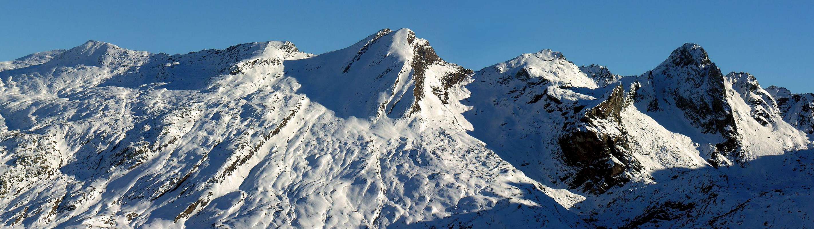
Located immediately to the West of the renowned Pass of Arietta (2.947m), between the latter and the Punta or Pointe of Miserino (3.010m) and confused by the mountainerrs Irving and Tyndale with the current Tête-de-la-Nouva calling the same Pic de la Nouva. Quoted but not named in the raised topographic I.G.M. (Italian Military Geographical Institute) in 1932, its exact name instead is Head or Tête de l'Arietta resulting as the first rocky elevation in the Southwest after the hill of the same name, is very popular both in the past which now for the famous San Besso Procession as well as for the transport of the ore iron from the Mines of Colonna to the Po Plain in Canavese (Piedmont). His ascent from the same is short and easy, but it requires attention and caution in case of wet ground, given the composition of the rocks. Good vantage point on the Vallon Urtier and on that of Rancio in Piedmont. This Summit is formed by a watershed crest between the Valle d'Aosta (Vallone della Nouva) and the Canavese in Piedmont Area (Vallons of Azaria and of Rancio); on the first of the two sides, moreover, a buttress in the shape of a great rocky snake, with smooth rock (of discontinuous difficulty in the path and subject to possible bypasses) and a leaning tooth, descends towards the NW, capable of separating the Vallone della Nouva from the adjacent one of the Miserino with its two small lakes (2.262m, 2.263m). The latter, which in fact doubles, is dominated by the homonymous peak (3.010m), in turn "connected" to the NE with the Testa dell'Arietta. The Normal Via climbs from Colle dell'Arietta along the NE Ridge, while the opposite crest, or SW, goes, with half a dozen roughnesses, to Punta del Miserino. It has no important walls, also due to the poor quality of the rock; this both as regards the Southern Side which, formed by three rocky steps alternating with as many gravel ledges, looms over the Rio del Rancio with its series of pastures, and as regards the Eastern Wall. The latter, which is nothing more than the continuation of the previous, dominates the Grange dell'Arietta (Arietta's Pastures; 2.275m) with its steep triangular wall, about 130 meters high and not yet climbed. Instead, the Northern side can be climbed as an alternative to the Via Normale with two possibilities:
1) - always starting from Colle dell'Arietta and gradually converging on the wall;
2) - going up from the Vallone dei Laghi Miserino and covering a long and boring stony ground and then joining in the upper part with the previous itinerary. In the middle climbs instead the route traced in June 2008 which, with an amusing and at times even challenging climbing, climbs between the two shields formed by reddish-bluish rocks that constitute the basal forepart; in the final part it goes directly over the pinkish-greyish rocky plates below the Top. Summit scarcely frequented despite the ease of the Normal Route or Crest NE, as well as the scarce time of climb of the route itself (0h'30).
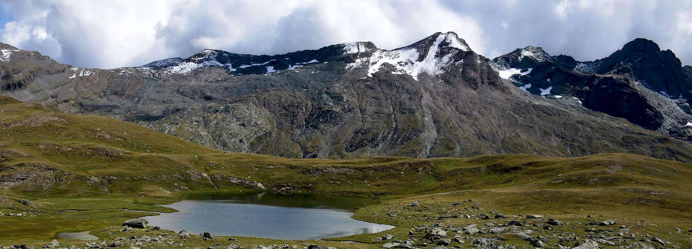
Collocata subito ad Occidente del Colle della Arietta (2.947 m), tra questo ultimo e la Punta o Pointe del Miserino (3.010 m) e confusa da Irving e Tyndale con l'attuale Tête-de-la-Nouva chiamando la stessa Pic de la Nouva. Quotata ma non nominata nella levata topografica della I.G.M. del 1932, il suo esatto toponimo invece è Testa o Tête de l'Arietta risultando come la prima elevazione rocciosa a Sudovest dopo l'omonimo colle, alquanto frequentato sia nei tempi passati che attualmente per la famosa Processione a San Besso nonché per il trasporto del minerale di ferro dalle miniere di Colonna alla Pianura del Po in Canavese in alto Piemonte. La sua salita dal medesimo risulta breve e facile, ma richiede una certa prudenza in caso di terreno bagnato, vista la composizione delle rocce. Buon punto panoramico sul Vallone dell'Urtier e su quello del Rancio in Piemonte. Questa Sommità é formata da una cresta spartiacque tra la Valle d'Aosta (Vallone della Nouva) ed il Canavese in Piemonte (Valloni di Azaria ad Est e del Rancio a Sudovest); sul primo dei due versanti, inoltre, un contrafforte a forma di serpentone roccioso, con roccia levigata (di discontinua difficoltà nel percorso e soggetto a possibili aggiramenti) ed un dente pendente, scende verso NO, atto a separare il Vallone della Nouva da quello adiacente del Miserino coi suoi due laghetti. Questo ultimo, che appunto si sdoppia, é dominato dall'omonima punta (3.010 m), a sua volta "allacciata" a NE con la Testa dell'Arietta. La Via Normale sale dal Colle dell'Arietta lungo la Cresta NE, mentre la cresta opposta, od O-SO, si indirizza, formando per strada una mezza dozzina di asperità, alla Punta del Miserino. Non presenta importanti pareti, anche per la non buona qualità della roccia; questo sia per quanto concerne il Versante Meridionale che, formato da tre gradoni rocciosi alternati ad altrettante cenge ghiaiose, incombe sopra il Rio del Rancio con la sua serie di pascoli, sia per quanto riguarda la Parete Orientale. Quest'ultima, che altro non é che la continuazione della precedente, domina con la sua ripida parete triangolare, alta circa 130 metri e non ancora salita, le Grange dell'Arietta (2.275 m). Invece, il Versante Settentrionale può essere salito come alternativa alla Via Normale con due possibilità:
1) - sempre partendo dal Colle dell'Arietta e convergendo gradualmente sulla parete, formata da rocce alquanto rotte;
2) - risalendo dal Vallone dei Laghi Miserino e percorrendo una lunga e noiosa pietraia per poi congiungersi nella parte alta con il precedente itinerario. In mezzo sale invece la via tracciata nel giugno 2008 che, con arrampicata divertente ed a tratti anche impegnativa, sale tra i due scudi formati da rocce rossicce-bluastre che costituiscono l'avancorpo basale della faccia; nella parte finale supera direttamente le placche rocciose grigiastre sottostanti la Vetta. Scarsamente frequentata nonostante la facilità della Normale o Cresta NE, nonché la brevità del percorso stesso (0h'30).
First Ascents
- First on the summit: unknown.
- In winter: unknown.
- NE Crest (Normal Via from Arietta Pass): unknown.
- West-southwest Ridge: R.L.G. Irving and H.E.G. Tyndale, (Aug 10th, 1912), in descent with traverse until Punta Miserino and Pass. In ascent (with almost complete path except two gendarmes) Osvaldo Cardellina, lone, (Jun 12th, 2008), from Pointe Miserino through Eastern Crest and Northern Face.
- N-NW Buttress ("Big Snake" Route between Testa dell'Arietta and Punta Miserino): Osvaldo Cardellina and Emilio Bertona, (Jul 28th, 2003), in ascent from Goilles Damon, Broillot Alp, Miserino Lochs with descent through Northeast Crest or Standad Via to Arietta Hill, Miserino Lakes, Broillot Pastures, Lillaz Hamlet.
- Northern Face (Normal Via from Arietta Pass or more in West variant from Miserino's Lakes): unknown.
- Northern Face (Central Direct Route on red/blue rocks between the forepart of the two rocky "shields" ): Osvaldo Cardellina, lone, (Jun 15th, 2008), in ascent from ,Lillaz, Broillot Alp, Miserino Lochs with descent through Northeast Crest or Standad Via to Arietta Hill, Miserino Lakes, Broillot Pastures, Lillaz Hamlet.
Getting There
BY CAR:- From Torino, Milano, etc: Motorway A5. Exit at Ivrea or Quincinetto (Piedmont). From Ivrea Town: before in West (Southern side) to Pont Saint Martin, Verrès, Saint Vincent, Chatillon, Nus, Aosta West (near Aymavilles) Municipalities; after from this last towards Cogne Valley in Southeast until Cogne.
- Aeroporto "Corrado Gex" Saint Christophe (Aosta).
Specific Road
- From Cogne Resort: in East-southeast towards Lillaz Fraction; from this last towards Urtier Vallon.
- From Aosta City before in West towards Aymavilles, after towards Vieyes, Epinel, Crétaz Hamlets until Cogne Common; from this last towards Lillaz Hamlet and Urtier's Valley.
Approach and Route
 |
 |
 |
 |
 |
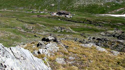
By Lillaz reach the fork about 2.580 meters between Peradzà Bassa and Gratton Coastlines and Nouvas/Miserino Vallons: from junction of paths n° 13/13B-13C go up by South direction passing the Peradzà Bassa and Gratton Coastline as far as the fork 2.580 meters around, under the quota 2.461m; from crossroads, leaving right (South-southwest) the path n° 13C towards Miserino Lakes, continue by left ramification or path n° 13B, VA (Aosta Valley Tour). Afterwards changing in South-southeast direction (rare yellow signs in existence), go up on grassy humps and rocky promontory, between Peradzà Bassa (Lower; in East) and Nouva Little Valley in right, coming contra the with same name point also head, in quota 2.850 meters about. From this point, abandon the "slender" track to East-southeast, crossed of Nouva Head the entire Northern Slope, and, by South direction, border completely the of same West Wall. Always through the very ancient mule-track, go up, by progressive more steep hairpins bend and with path less and less thick and more and more subject to landslips, up to contra its face (from this rocks falls danger); continue, through a large, inclined and rubble ledge, crossing of wall completely the base, by to Nouva Valley exposed great ribbings (much delicate hard snowfields extant). At last, by a below the face about thirty meters in descent traverse, reach the great boulder under the pass (niche in the shape of shelter and suitable for "salle à manger" (food place), under the rocky cliff; by blue, polished and slippery rocks briefly to pass (2.947m; EE/F; EEA/F+ snowfields extant; 1h'45/2h'00 from fork 2.580m~; 2h'30 from Broillot Pasture; 2h'15/2h'30 from Sogno di Berdzé Refuge; 4h'30/5h'00 from Lillaz Village). By the narrow carving of the hill climb through easy bluish rocks, rounded and smooth towards the just above tiny bell; from this continue on the thread of the Northeast Ridge through stacked boulders or bypassing some short right section to the right (West) easily and quickly reaching the Summit. (EE/F/F+; 0h'30 from pass).
Da Lillaz raggiungere il bivio 2.580 metri circa tra le Coste Bassa di Peradzà e Gratton ed il Vallone Nouva/Miserino: dalla congiunzione dei sentieri n° 13/13B-13C risalire con direzione Sud superando la Bassa di Peradzà e la Costa Gratton sino al bivio 2.580 metri circa, sottostante la quota 2.641 m; lasciando a destra (Sud-sudovest) il sentiero n° 13C per i Laghi del Miserino, continuare con la ramificazione di sinistra o sentiero n° 13B, VA (Tour de la Vallée d'Aoste). Cambiando progressivamente direzione in Sud-sudest (rari segnali in color giallo), continuare, su dossi e promontori erbosi a cavallo tra la Bassa di Peradzà ad Est ed il piccolo Vallone della Nouva a destra, portandosi a ridosso dell'omonima punta o testa. Qui giunti ed in quota 2.850 metri circa abbandonare l'esile traccia, che indirizzandosi ad Est-sudest attraversa l'intero Versante Settentrionale della Testa della Nouva, e, con direzione Sud, contornare l'intero Versante Occidentale della stessa. Sempre con l'antica mulattiera, guadagnare quota con tornanti più ripidi e con il sentiero che diviene sempre più franoso sin contro la sua parete (pericolo di caduta di pietre); proseguire sull'ampio cengione che ne taglia alla base l'intero versante, passando alcuni tratti esposti su costoloni rocciosi rivolti al Vallone della Nouva (molto delicato se con neve dura). Infine, con una discesa di una trentina di metri e di traverso alla base della parete, raggiungere il gran masso sottostante al colle (nicchia atta a ricovero ed a salle à manger sotto il salto roccioso); per rocce color blu, molto levigate e soprattutto scivolose se bagnate, raggiungere il Colle dell'Arietta (2.947 m; EE/F, con neve EEA/F+; 1h'45/2h'00 dal bivio 2.580 metri circa; 2h'30 dall'Alpe Broillot; 2h'15/2h'30 dal Rifugio Sogno di Berdzé; 4h'30/5h'00 da Lillaz). Dall'intaglio del colle salire tramite facili rocce bluastre, arrotondate e lisce all’appena soprastante campanella; da questa proseguire sul filo della Cresta Nordest per massi accatastati oppure aggirando qualche breve tratto giusto sulla destra (Ovest) raggiungendo facilmente e rapidamente la Sommità.(EE/F/F+; 0h'30 dal colle).


L'itinerario è classificato EE/EEA/F/F+.
Equipment
For Hiking or Mountaineering; with rope, ice-axe and crampons in snow presence.Da Escursionismo od Alpinismo; con corda, piccozza e ramponi se con neve.
Campings
There are plenty of camping sites along the Gran Paradiso valleys. Remember that free camping is forbidden (except for emergency reasons, over 2.500m, from darkness until dawn).Huts
 |
Mountain Condition
- Meteo: you can find all the needed informations at the official site of the Valle d'Aosta Region:
- Valle d'Aosta Meteo
Webcam
- WEBCAM on Aosta Valley:
- Webcam
Books and Maps
BOOKS:
- "Guida dei Monti d'Italia–Emilius Rosa dei Banchi Parco del Mont Avic" di Giulio Berutto e Lino Fornelli-Club Alpino Italiano/Touring Club Italiano, Marzo 2005 (in Italian).
- "I Rifugi della Valle d'Aosta" di Stefano Ardito, Ed. Guide iter, Febbraio 2003.
- "Diari Alpinistici" di Osvaldo Cardellina e Indice Generale accompagnato da Schedario Relazioni Ascensioni 1964-2019 (inediti).
 |
 |
 |
MAPS:
- Enrico Editore Ivrea-Aosta "Gruppo del Gran Paradiso" 1:50.000.
- L'Escursionista "Valle di Cogne Carta dei Sentieri" 1:25.000.
 |
 |
Important Information
- REGIONE AUTONOMA VALLE D'AOSTA the official site.
- FONDAZIONE MONTAGNA SICURA Villa Cameron, località Villard de la Palud n° 1 Courmayeur (AO) Tel: 39 0165 897602 - Fax: 39 0165 897647.
- SOCIETA' GUIDE ALPINE DI COGNE Tel. 347/9473526 – 328/1373728.
- A.I.NE.VA. (Associazione Interregionale Neve e Valanghe).
- A.IA.T. Cogne Gran Paradis via Bourgeois n° 34 Tel. 0165-74040. E-mail: aiat@cogne.org
- Ezio Sport articoli sportivi - via Bourgeois n° 64 Tel. 0165-74204.
Useful Numbers
- Soccorso Alpino Cogne (SAR) Tel. 3482685406.
- Protezione Civile Valdostana località Aeroporto n° 7/A Saint Christophe (Ao) Tel. 0165-238222.
- Bollettino Meteo (weather info) Tel. 0165-44113.
- Unità Operativa di Soccorso Sanitario Tel. 118.
External Links
- P.N.G.P. official site It's the official site of the Parco Nazionale del Gran Paradiso (in five languages)
- parco.nazionale.gran.paradiso Another complete site concerning the Gran Paradiso National Park, with a lot of information (in three languages).
Acknowledgements
I am greatly indebted to my friend "Osva" for the detailed description of the route, all texts and translation into English.