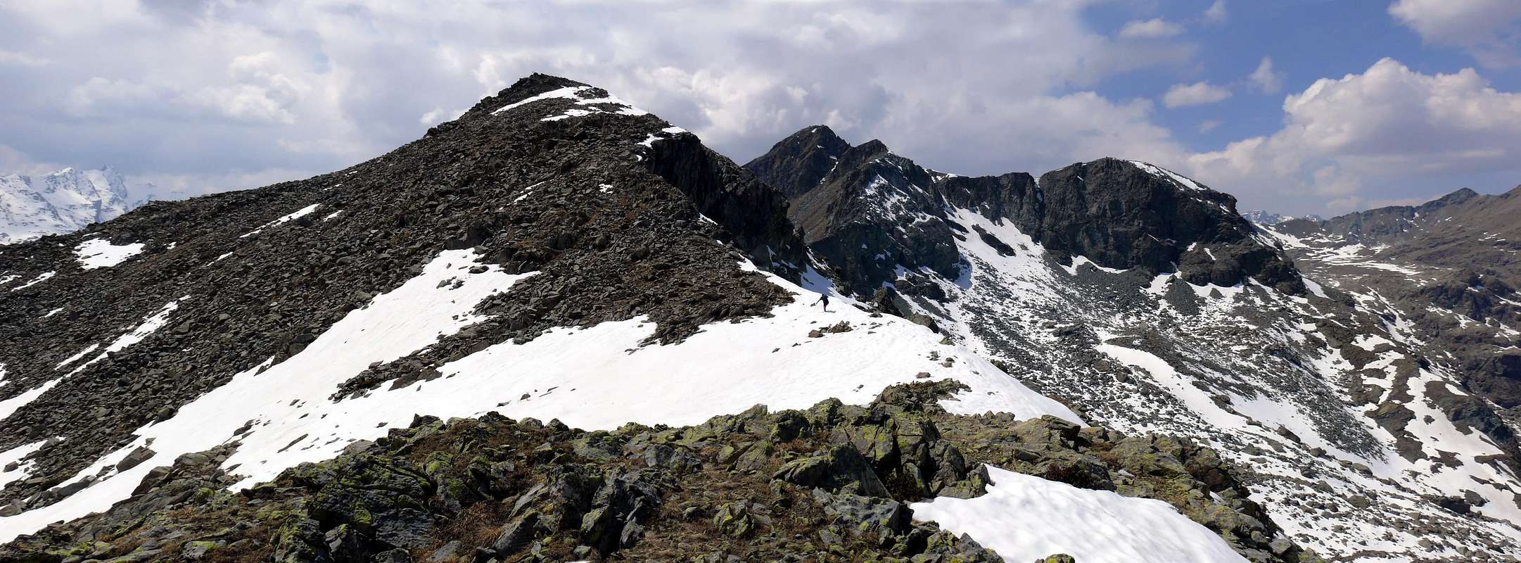
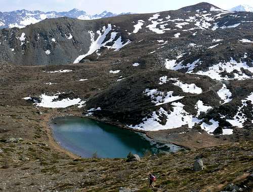
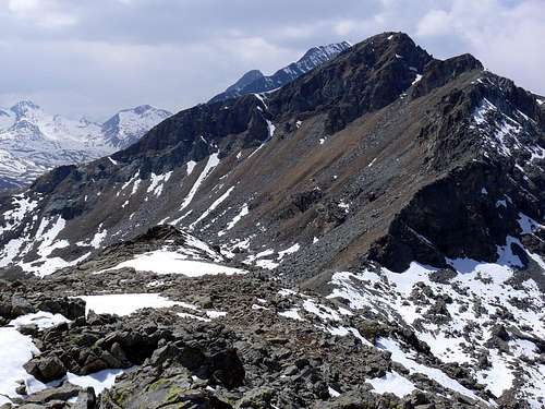
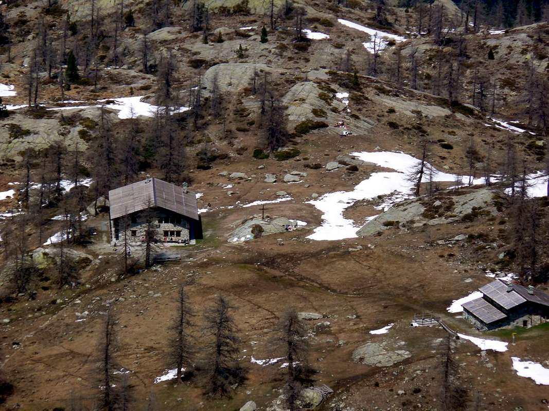
Situated on the long crest that, going down from the Punta Tersiva (3.515m) maximum elevation, after the Monte Emilius (3.559m), of the mountainous chain to Southern of the River Dora Baltea beginning from the entry of the Valley of Cogne and up to the floor valley, above the to lot of small Town of Pont Saint Martin in the Valley of Aosta and on the lowland of beautiful City of Ivrea, "with the red towers". Following the crest watershed, departing from Tersiva Point, we will have in succession a series of mountains that they find their peak in the Mont Glacier (3.186m), to which small Subgroup also belongs the Tête des Hommes (= the Men's Head); in fact departing from this peak the dividing crest the Champorcher' Valley from those of Fénis-Clavalité in North, at first, and then from that of Champdepraz, said or Lochs's Valley. In order the same one, after two small Necks said of the Gran Rossa (= Great Red Pass) it raises again him to the homonym Point (2.866m), it goes down to a secondary collar to reach the Bocon Damon or Quota 2.792 m, so known by the inhabitants on the spot; after another small unnamed hill on the papers but known as Pass Raty (2.592m) and almost exclusively frequented by the hunters, forming a turn to arc the crest goes up again to the well most evident and marked Tete des Hommes. As top surely of not great importance, the same one him "it proposes" detaching itself and delineating very well itself both from the slope Raty-Vernouille that from that Northern, where it overhangs the whole splendid series of surrounding lakes the Barbustel Refuge (2.200m). The same is site in pleasant way among three lakes: the White, the Black and the Vallette Lake more to East; rather rarely frequented (perhaps for his enough tiresome aspect, if observed from the lakes or from the basin of the Raty, where it raises him with a dizzy but brief West Crest; AD; also III°) in reality introduces an easy and sure slope along the Slope Southeast and only a few tedious in the crossing, along a great stony ground with enormous "clapeys" (= great stacked rocks). To cross, before to West and afterwards with Northwest direction, from the common path n° 10 that from the Villages of the Petit Mont Blanc (1.537m) and of the Grand (1.683m) or, and better, from that superior of La Cort (1.800m around; term of the road asphalted with possibility to continue with the cars along the Real Road of thin Dondena to a small parking with signalings for the shelter however.) From this point (rich and various illustrative poster designer also with maps in site) even and besides the entry into the entire, complete and really wild
NATURAL PARK of the MOUNT AVIC
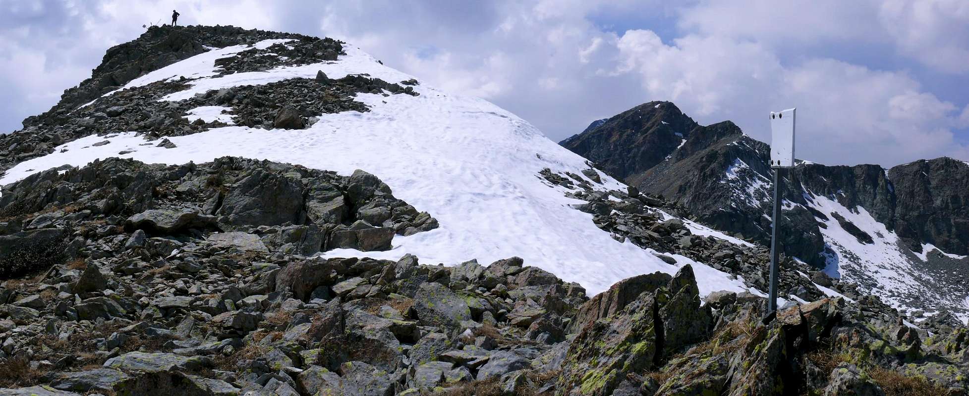
with its valleys and its walloons, at times, also of not easy access (above all on the slope of the Municipality of Champdepraz) and with its ironmines and of copper, by then abandoned; poorly known (* if not in the near area to the shelter with the succession of its lakes actually to the Great Lake or to the Medzove Pass (2.614m), where the path intervalleys transits n° 102 that crossing of valley in the valley, it actually reaches the Pont Suaz Fraction, to the doors of the City of Aosta), but not for this less fascinating and deserving of to visit. The same path, gone up again to the Alp her Grand Cort (1.944m), transiting for the Lac Muffé (2.019m), it goes up again to the Hill of the White Lake (2.308m) to get in himself in the Valley of the Lakes with his Gran Lake or Grand Lac (2.492m), the greatest of the whole Valley of Aosta. And it is really to this hill that him "league" our mountain with his Crest Northeast that, gone down to a further secondary pass (2.450m around) and momentarily raised again him to a small rocky tower, said for the note "Mont Torretta" also and better "La Torretta" (2.538/9m), it definitely goes down on the same. Pleasant and surely unusual trip (splendid with snowy slope and therefore for the ski-mountaineering or with snowshoes) and reserved to those people that commonly love exit out of the roads wisecracks and crowded with people; I detach that he mostly underlines really abandoning the path for the hill, where in summer a terrifying human flood pours again him to insert him in a small and sour "vallone" forgotten by God and by the men. To the return, after the descent through the same slope, a brief crossing in quota on stony ground, doubling to the base and toward Northeas "The Turret", to the pass and relative small descent to the shelter with a beautiful lunch to "polenta" (= yellow corn meal) and chamois or "polenta" buck they complete in great way the day! To reenter in the reality and not to be keep silent to be you of the asocial ones... Beautiful sights on the district, with the triangular Point Tersiva and the, more massive, Mont Glacier, that from here it appears tall, and its "Southern great Shoulder" or Quota 3.003m, as well as the next Mont Delà (3.139m). In Northwestern distance the GROUP of the Emilius and the Roises, while to South he raises, in form of sabre, the beautiful Rosa dei Banchi (3.164m), mountain symbol of the Valley of Champorcher, to the border with the near Piedmont (in succession from Northeast to West, Orco, Locana and Ceresole Royal Valleys). The same is anticipated and advanced of the Chain of the Gran Heaven that, from the same one, it extends him to boundless sight of eye toward the Valleys of the Isère, in distant fascinating France.
Situata sulla lunga cresta divisoria che, scendendo dalla Punta Tersiva (3.515 m) massima elevazione, dopo il Monte Emilius (3.559 m), della catena montuosa a Meridione del Fiume Dora Baltea a partire dall'ingresso della Valle di Cogne (dal Comune di Aymavilles) e fino al fondovalle, sopra la piccolissima Città di Pont Saint Martin in Valle d'Aosta e sulla pianura della bella Città di Ivrea, "dalle rossi torri". Seguendo la lunga ed articolata cresta spartiacque, partendo dalla Tersiva, avremo in successione una serie di montagne che trovano il loro culmine nel Mont Glacier (3.186 m), al quale piccolo Sottogruppo appartiene quindi anche la Tête des Hommes (= Testa degli Uomini); infatti partendo da questa vetta piramidale la cresta divisoria la Valle di Champorcher da quelle di Fénis-Clavalité, dapprima (ad O), e poi da quella di Champdepraz, detta anche Valle dei Laghi si allunga sull'asse Ovest/Est, seguendo in parallelo in pratica il corso della Dora Baltea. In ordine la medesima, dopo due Colletti detti della Gran Rossa, si rialza all'omonima Punta (2.866 m), ne discende ad un successivo e secondario per raggiungere il Bocon Damon oppure Quota 2.792 m, così conosciuto dagli abitanti in loco; dopo un altro piccolo colle, innominato sulle carte ma conosciuto dai valligiani come Colle Raty (2.592 m) e frequentato quasi esclusivamente dai cacciatori, formando un giro ad arco la cresta risale alla ben più evidente e marcata Tete des Hommes. Per quanto cima sicuramente di non grande importanza, la stessa si "propone", staccandosi e delineandosi molto bene, sia dal versante Raty-Vernouille (Valle di Champorcher) che da quello Settentrionale, dove sovrasta tutta la splendida serie di laghi circostanti il Rifugio Barbustel (2.200 m). Lo stesso é sito in modo ameno in un piccolo promontorio in mezzo a tre laghi: il Bianco, il Nero ed il Lago Vallette più a Oriente; alquanto raramente frequentata (forse per il suo aspetto abbastanza ostico, se osservata dai laghi o dal bacino del Raty, dove s'innalza con una vertiginosa, ma breve, Cresta Ovest (AD; anche III°); in realtà presenta una salita facile e sicura lungo il roccioso e detritico Versante SE, soltanto un poco tediosa nell'attraversamento, lungo una grande e desolata pietraia con enormi "clapeys" (= grandi massi accatastati). Attraversare, dapprima verso O e quindi direzionandosi a NO dal comune sentiero n° 10, che dai Villaggi del Petit Mont Blanc (1.537 m) e del Grand (1.683 m) o, e meglio, da quello superiore di La Cort (1.800 m~; termine della strada asfaltata con possibilità comunque di proseguire con l'auto lungo la Strada Reale di Dondena fino ad un piccolo pargheggio con segnalazioni per il rifugio.) Da questo punto (ricca e varia cartellonistica anche illustrativa con mappe in sito) si effettua inoltre anche l'ingresso nell'integro, incontaminato e veramente selvaggio
PARCO NATURALE del MONTE AVIC
con le sue valli ed i suoi valloni, a volte, anche di non facile accesso (soprattutto sul versante del Comune di Champdepraz) e le sue antiche miniere di ferro e di rame, ormai abbandonate. Scarsamente conosciuto (* se non nell'area vicina al rifugio con la successione dei suoi laghi sino al Gran Lago od al Col Medzove (2.614 m), dove transita il sentiero intervallivo n° 102 che, attraversando di valle in valle, arriva sino alla Frazione del Pont Suaz, alle porte della Città di Aosta), ma non per questo meno affascinante e meritevole di una visitazione. Lo stesso sentiero, risalito all'Alpeggio di La Grand Cort (1.944 m), transitando per il Lac Muffé (2.019 m), rimonta al Colle del Lago Bianco (2.308 m) per introdursi nel Vallone dei Laghi con il suo Gran Lago oppure Grand Lac (2.492 m), il più grande dell'intera Valle d'Aosta. Ed é proprio a questo colle che si "lega" la nostra montagna con la sua Cresta NE che, scesa ad un ulteriore colle secondario (2.450 m~) e rialzatasi momentaneamente ad una torretta rocciosa, detta per l'appunto "Mont Torretta" o meglio "La Torretta" (2.538/9 m), scende definitivamente sullo stesso. Gita piacevole e sicuramente inconsueta (splendida con innevamento e quindi per lo sci-alpinismo o con racchette da neve) e riservata a coloro che amano uscir fuori dalle strade comunemente battute ed affollate; stacco che si evidenzia maggiormente proprio abbandonando il sentiero pel colle, dove di estate si riversa una terrificante fiumana umana, per inserirsi in un piccolo ed aspro vallone, dimenticato da Dio e dagli uomini. Al ritorno. dopo la discesa lungo il medesimo versante, una breve traversata in quota, doppiando alla base e verso NE "La Torretta", al passo e relativa discesina al rifugio con bel pranzo a polenta e camoscio o cervo completano alla grande la giornata! Per rientrare nella realtà e non essere tacciati d'essere degli asociali ... Belle viste sul circondario, con la snella, triangolare e lucente Punta Tersiva ed il più tozzo Mont Glacier, che da qui appar altissimo, ed il suo "Spallone Meridionale" o Quota 3.003 m, nonché l'attiguo piamidale Mont Delà (3.139 m). In lontananza a NO il GRUPPO dell'Emilius ed il Sottogruppo delle Roises, mentre a Meridione, sopra il Vallone dei Banchi e verso il Lago Miserin (2.578 m), s'innalza, a guisa di sciabola, la slanciata Rosa dei Banchi (3.164 m), simbolo della Valle di Champorcher, al confine con il vicino Piemonte (in successione da E-NE ad O-NO Valli dell'Orco, Locana e Ceresole Reale). La stessa é anticipatoria della Catena del Gran Paradiso dalla medesima estendentesi a sconfinata vista d'occhio verso le Valli dell'Isère, nella lontana fascinosa Francia.
First Ascents
First on the Summit: Unknown.
In Winter: Unknown.
W Edge: Unknown.
NE Ridge: Unknown.
SE Slope and NE Crest in final part (Standard Route): Unknown.
Getting There
BY CAR:
From Torino, Milano, etc: Motorway A5. Exit Pont Saint Martin for then to continue on SS26 toward Hone Bard.
From Switzerland: through the Grand Saint Bernard Tunnel or the namesake pass. Drive to Aosta, Fénis Village or Verrès and Hone Bard.
From France: through Mont Blanc Tunnel or Petit Saint Bernard Pass. It isn't necessary to take Motorway A5: you can drive on SS.26, in the direction of Aosta and Fénis Village or Verrès and Hone Bard.
BY PLANE:
Aeroporto "Corrado Gex" Saint Christophe (Aosta).
Approaches of Base for whole the AREA neighbour the "ROYAL ROAD"
AREA neighbour the "ROYAL ROAD" of the SAVOIA" From the exit of Statal Motorway to Pont Saint Martin reach, through a Main Road, Donnas Commune: immediately after the village (interesting view on the adjoining road to console adorned by a beautiful Roman arc). Some hundred meters, to the of near of I approach Dora Baltea Stream, bridge of the to cross they govern the indication Champorcher; to follow the Regional Road for this place. Of to go beyond the of Commune Pont Bozet (1.080m; splendid and interesting visit through the horrifying Ravine of Ratus), clinged under a deep gorge to South and below the vertical rocky walls of Mount Charvatton (1.787m) in Northern, inhabitated fractions and villages (in succession going up from East to West: Chataigne, Pialemont, Trambeseire, Savin, Frassiney, La Place, Salleret, Coudreyt, Mellier (1.293/9m)), this last more extended, and, finally, to reach the Village-Chief town called Chateau (= Castle: 1.427m). Immediately is found the indication to Fractions Gontier, Byron (1.574m), Collin (1.614m), Petit/Grand Mont Blanc (1.644m; 1.683m) and Royal Savoia Route to Dondena Village (2.100m about), for the more part in soil. (* To Southwest, on contrary, departure for the deviation toward the beautiful Chardonney Resort (1.455m) - (1.464m), site in an enough extended tableland, nearby the Torrent Ayasse, and near the beginning of Larìs Cable-way; as well as the neighbour Villages of Ronchas (1.464m) and of Perruchon (1.537m), at the end of secondary small walloon). Road of this to follow, not too much great, for different km; the first part of the same one is in asphalt for then to continue in beaten earth. Usually the conditions of this second are enough good and however it are worthwhile to ask for information in the zone, considering that lately works of government maintenance are performed. Road of this to continue, the ancient one of they govern of coincident Real Road, octave flute than to the of until and underlying the Dondena little Village, near the Torrent Ayasse (2.100 meters; at the end a signal it prevents the traffic, immediately in the narrow as well as limited parking lot; poster signallers in cover of bench of an in wood; great crowd confusion of relative of and; a feet 1h'30/2h'00 from the term of the asphalted road).
AVVICINAMENTO di BASEper tutta la ZONA propinqua alla "STRADA REALE dei SAVOIA" Dall'uscita dell'Autostrada Torino/Milano-Aosta presso l'abitato di Pont San Martin raggiungere il successivo Paese di Donnas: immediatamente dopo il villaggio (interessante veduta sull'attigua strada consolare ornata da un bel arco romano). Alcune centinaia di metri, appresso vicino alla Dora Baltea, attraversare il ponte con l'indicazione per la Valle di Champorcher; seguire la strada regionale per questa località. Oltrepassare il Comune di Pont Bozet (1.080 m; visita splendida ed interessante all'orripilante Orrido del Ratus, abbarbicato in una profonda gola a Meridione ed alle falde delle imponenti pareti del Mont Charvatton (1.787 m) che lo sovrastano a Settentrione, e raggiungere, passando dapprima presso diverse piccoli villaggi e frazioni abitate (in successione salendo da E verso O: Chataigne, Pialemont, Trambeseire, Savin, Frassiney, La Place, Salleret, Coudreyt, Mellier (1.293/9 m), villaggio di maggiori proporzioni) per pervenire alla fine al bel Villaggio del Capoluogo di Chateau o Castello (1.427 m). Subito a monte della strada si trova l'indicazione per le Frazioni di Gontier, Byron (1.574 m), Collin (1.614 m), Petit/Grand Mont Blanc (1.644 m; 1.683 m), nonché per la Strada Reale in direzione del Villaggio di Dondena (2.100 m~), per la maggior parte in terra battuta. (* Verso SO invece parte la deviazione per il bel centro Turistico di Chardonney (1.455 m), sito nell'estesa piana, accanto al Torrent Ayasse, ed alla partenza delle Funivie del Larìs; nonché i vicini Villaggi di Ronchas (1.464 m) e di Perruchon (1.537 m), verso il fondo del piccolo vallone secondario). Seguire questa strada, non troppo grande, per diversi km; la prima parte della stessa è in asfalto per poi proseguire in terra battuta. Di solito le condizioni di questa seconda sono abbastanza buone e comunque conviene richiedere informazioni in zona, visto che ultimamente sono state eseguite opere di manutenzione. Seguire questa strada, coincidente perlappunto con l'Antica Strada Reale dei Savoia, fino al piccolo e sottostante Villaggio di Dondena, abbarbicato ed in ordine sparso presso il Torrente Ayasse (2.100 m; al termine un segnale impedisce il traffico, subito dopo il ristretto nonché limitato parcheggio; cartelli segnalatori in una panchina coperta in legno; grande folla e relativa confusione; a piedi 1h'30/2h'00 dal termine della strada asfaltata).
Approach to Pass of Lago Bianco (White Loch)
From the small Village of La Cort, to continue verse West-northwest on the Real Road in earth for Dondena Village reaching not very after a small parking lot near and along the same one (1.830/40m around; noumerous signalings and entry "official" in the Park of the Avic Mountain); to begin awry immediately with the path n° 10 that part (North) and it goes up again with a steep zigzag bringing itself, with direction Northeast, at first toward a small secondary torrent and subsequently placing side by side that more important descendant from the impending Loch Muffé. To go up again along the bank right hydrographic of the same one with the path, almost mule-track, that unties him with a series of hairpin bends flanking the wood, alternate to rectilinear lines in diagonal. To go out, leaving on the right (East) the deviation for the "Alpage" of La Grand Cort (1.944m, that from he is quietly seen here "abandoned" among green pastures) so in the superior plateau in her "wide narrow passage" among the appendixes of the Mont Ros (2.289m) to West and you it terminal of the SW Crest that it climbs to the Top Perche (2.396m; also with the toponym of Perché, or Perforated), or Southern shoulder of the Cima Piana (= Plain Top also called Mont de Panaz 2.512m). Continue on the floor of the walloon through less steep slope with run mostly "open" and, abandoning on the left (West) the deviations for the Lacke Vernouille (2.145m) with the paths n° 9C, 10B and, momentarily, also the n° 10, to climb with the n° 10C reaching the ruin of the old Alp Muffé (2.076m), close to the homonym Lake suffered to East I approach (2.119m; 0h'30). From this to ascend up with direction Northwest in a zone even more disclosed among small backs with lawns and moraines (small sources that gush out a little everywhere) again meeting the path "of base" n°10, that it originates "of return" from the Lac Vernouille, few more than hundred meters more aloft. To abandon therefore the aforesaid variation continues with, that continues in opposite direction (Northeast) toward the nearby Colle del Lago Bianco (= White's Loch Pass; 2.308m), and to proceed with this last I pour the neighbour Col de la Croix (= Hill of the Croix; 2.287m), reaching it with a final line of a little steep (E; 1h'15/1h'30).
Dal piccolo Villaggio di La Cort, continuare verso O-NO sulla Strada Reale in terra battuta per Dondena raggiungendo non molto dopo un piccolo parcheggio presso e lungo la medesima (1.840/50 m~; nunerose segnalazioni ed ingresso "ufficiale" nel Parco del Monte Avic); iniziare con il sentiero n° 10 che parte subito a monte (N) e risale con un ripido zig-zag portandosi, con direzione Nordest, dapprima verso un torrentello secondario e successivamente affiancando quello più importante, discendente dal soprastante Lac Muffé. Risalire lungo la sponda idrografica destra del medesimo con il sentiero, quasi mulattiera, che si snoda con una serie di tornanti affiancando il bosco, alternati a tratti rettilinei in diagonale. Uscire, lasciando sulla destra (E) la deviazione per l'Alpe La Grand Cort (1.944 m, che da qui si vede tranquillamente "adagiata" tra verdi pascoli) così nell'altipiano superiore nella "larga strettoia" tra le appendici del Mont Ros (2.289 m) ad O e la propaggini terminali della Cresta SO che sale alla Cima Perche (2.396 m; anche con il toponimo di Perché, ovvero Forata), o spalla Meridionale della Cima Piana o Mont de Panaz (2.512 m). Continnuare sul fondo del vallone con percorso alquanto meno ripido e maggiormente "aperto" e, abbandonando sulla sinistra (Ovest) le deviazioni per il Lac Vernouille (2.145 m) con i sentieri n° 9C, 10B nonché, momentaneamente, anche il n° 10, salire con il n° 10C raggiungendo il rudere dell'Alpe Muffé (2.076 m), accanto all'omonimo Lago, subito ad E appresso (2.119 m; 0h'30). Da questo proseguire con direzione NO in una zona ancora più dischiusa tra piccoli dossi con prati e morene (piccole sorgenti che sgorgano un poco dovunque) incontrando nuovamente il sentiero "di base" n° 10, che proviene "di ritorno" dal Lac Vernouille, poco più di un centinaio di metri più in alto. Abbandonare quindi la variante seguita, che continua in opposta direzione (NE) verso il Col de la Croix (2.387 m), e procedere con questo ultimo verso il Colle del Lago Bianco (2.308 m), raggiungendolo con un tratto finale di poco più ripido (E; 1h'15/1h'30).
Route
From the quota 2250/300 meters around, to the intersection of the paths n° 10C and 10, to abandon these last ones leaving them on the right (in direction of trailway toward of the White Lake (2.308m) and of the Cross Pass (2.287m), the both between Champorcher and Champdepraz's Valleys) in opposite addressing to West; to cross at first along the slope with bushes, blocks, debris and deposits for then, going down of some about ten meters, to go himself in a minuscule walloon which it follows a stony ground of great "clapeys." To cross it around 2.225/35 meters, doing small "stunts" among the sundry rocks at times too outdistanced between them and therefore without solution of continuity in the traverse and passing, subsequently, in the middle of two small rocky bends; doubling to the base the South Wall of the "La Torretta", to get in himself to quota 2.300 meters about in a small "vallone", site between the same one and the Tête des Hommes. Flanking the same, to go up again it with direction North-northwest almost bringing himself on the Southeast Slope of this last. Long moraines, shed blocks and some lean rocky bends, to climb holding more or less himself in the center of the vallon, leaving on the left the Southeast Slope real, discreetly constituted by one steep "strained" of stops broken; to reach easily so a wide saddle among these two mountains (2.450 meters around) for then to continue with easy slope in direction Southwest through the Crest Northeast, with possibility to find some snowcappeds residue, and with this to reach, again without particular difficulties, the Peak with its three signals (E; 0h'30/2h'00 from the parking lot on Royal Road and in quota 1.830/40m about).
VARIANT: from the intersection of the paths n° 10/10B, to quota 1.990/2.000 meters around, to surrender this last forehand to the Loch Muffé continuing instead through the first one that, climbing toward West, it reaches a ruin of old alp (2.071m), where it changes direction toward Northeast in direction of the Lacke Muffé. As soon as over the same to ford a first small torrent reaching a following of it, that, after having crossed the path n° 9C, adressed to the Loch Vernouille, he goes up again up to his origin gradually inserting himself in the precedent itinerary.
Dalla quota 2.250/300 metri circa, all'incrocio dei sentieri n° 10C/10, abbandonare questi ultimi lasciandoli sulla destra (in direzione dei due Colli del Lago Bianco e de la Croix o Croce) rivolgendosi invece verso O; attraversare dapprima lungo il versante con cespugli e terreno con blocchi e detriti per poi, scendendo di alcune decine di metri, portarsi in un minuscolo vallone al quale fa seguito una pietraia di grandi "clapeys". Attraversarla sui 2.225/35 metri circa, facendo piccole "acrobazie" tra i varii massi a volte troppo distanziati tra di loro e quindi senza soluzione di continuità nella traversata e passando, successivamente, in mezzo a due fascette rocciose; doppiando alla base tutto il Versante Meridionale della "La Torretta", introdursi a quota 2.300 metri in un valloncello, sito tra la medesima e la Tête des Hommes. Fiancheggiarlo dappresso sul suo margine Orientale e risalire con direzione N-NO portandosi. poi, quasi sul Versante SE di quest'ultima. Lungo morene, blocchi sparsi e qualche sparuta lastronata rocciosa, salire tenendosi più o meno nel centro del vallone, lasciando sulla sinistra il Versante SE vero e proprio, costituito da una discretamente ripida "colata" di blocchi spezzati; raggiungere così una larga sella tra queste due montagne (2.450 m~) per poi continuare con facile salita in direzione SO tramite la Cresta NE, con possibilità di trovarvi qualche nevato residuo, e con questa raggiungere la Vetta con i suoi tre segnali (E; 0h'30/2h'00 dal parcheggio sulla Strada Reale a quota 1.830/40 m~).
VARIANTE: dall'incrocio dei sentieri n° 10/10B, a quota 1.990/2.000 m~, abbandonare questo ultimo diretto al Lac Muffé proseguendo invece tramite il primo che, indirizzandosi e salendo "dolcemente" verso O, raggiunge un rudere (2.071 m), ove cambia direzione a NE in direzione del Lac Muffé. Appena oltre lo stesso guadare un primo torrentello raggiungendone un successivo, oltre il quale, dopo aver incrociato il sentiero n° 9C che con traversata ad Occidente adduce al Lac Vernouille, si risale fino alla sua origine inserendosi gradualmente nel precedente itinerario.
Difficulty
The route can be considered from E; F.
L'itinerario è da classificarsi E; F.
Equipment
For Excursion and ski or snowshoes, in presence of strong snow.
Da Escursionismo con sci o racchette da neve, in presenza di innevamento.
Campings
Remember that free camping is forbidden (except for emergency reasons, over 2.500m, from darkness until dawn).
"Guida delle Alpi Occidentali" di Giovanni Bobba e Luigi Vaccarone C.A.I. Sezione di Torino Volume II (parte II), 25 Maggio 1896.
"Guida dei Monti d'Italia – Emilius Rosa dei Banchi-Parco del Mont Avic" di Giulio Berutto e Lino Fornelli - Club Alpino Italiano/Touring Club Italiano, Marzo 2005.
"Diari Alpinistici" di Osvaldo Cardellina e Indice Generale accompagnato da Schedario Relazioni Ascensioni 1964-2019 (inediti).
MAPS:
Ingenia "Parco Naturale del Mont Avic" Carta dei sentieri 1:25.000.
Enrico Editori Ivrea "Carta turistica del Canavese" 1:100.000
Enrico Editore Ivrea-Aosta "Gruppo del Gran Paradiso" 1:50.000.
L'Escursionista editore "Valle di Champorcher Parco Mont Avic" Carta dei Sentieri (11) 1:25.000.
L'Escursionista "Valle di Cogne" Carta dei Sentieri 1:25.000.
Parents refers to a larger category under which an object falls. For example, theAconcagua mountain page has the 'Aconcagua Group' and the 'Seven Summits' asparents and is a parent itself to many routes, photos, and Trip Reports.

 6617 Hits
 81.84% Score
 14 Votes