
|
|
Mountain/Rock |
|---|---|
|
|
35.71670°N / 76.70000°E |
|
|
Mountaineering |
|
|
26469 ft / 8068 m |
|
|
Overview
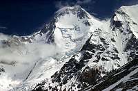
GI seen from close to BC
Contrary to general belief Gasherbrum doesn't mean "shining wall". The name comes from the Balti words rgasha, which means beautiful and brum which means mountain. There are six Gasherbrum Peaks. Gasherbrum I, also known as K5 and Hidden Peak, a name given by William Martin Conway in 1892 in reference to its extreme remoteness. It is the highest peak among them. It is also the 11th highest peak in the world and is the second highest in the Karakoram Range. It is one of the four 8,000m peaks located in a tight cluster on the upper reaches of the Baltoro glacier, the main access route to the mountains which cuts through the center of the Karakoram Range.
The Karakoram is the second tallest mountain range on earth. It lies about a thousand miles west of Nepal's Himalaya mountain range. The range is bordered by Tajikistan, China, Pakistan, Afghanistan, and India. It is a condensed cluster of high peaks with 60 mountains over 6900 meters. Of the world's fourteen highest mountains, four are located within the Karakoram Range: K2, Gasherbrum I and II, and Broad Peak.
Gasherbrum is a remote group of high peaks in the Karakoram, located at the northeast end of the 36-mile Baltoro glacier. The group forms a semi-circle around its own South Gasherbrum Glacier. A French Expedition led by H. De Segogne made first attempt in 1936, but they could not climb beyond Camp V at a height of 6797 meters. However, in 1958 an American Expedition led by Nich Clinch made the first ascent of Gasherbrum I. Pete Schoening and Andy Kaufman were first to reach the summit.
The peak was also the venue of the world’s first 8,000 meter climb in pure Alpine Style. This means that the start of the climb is done from the bottom of the mountain and all gears are carried on the way, if any bivouacs, they will be found on the way. No route preparation is done. Supplemental oxygen is not used. Reinhold Messner and Peter Habeler achieved this unprecedented feat in August, 1975. On 8 August 1975, they began their climb. They had no rope with them, no supplemental oxygen, just personal climbing gears. On August 10th they summitted the peak and thus introduced pure Alpine style climbing to the Karokaram.
Gasherbrum I is one to the "least popular" of the 8000 meter peaks. It still has less than 200 ascents and is in tenth spot on the ascent-list for the 8000 meter peaks. It is also one of the peaks with least deaths, but this probably has to do with the fact that only really experienced mountaineers try a peak as difficult at Gasherbrum I.
The most common way to climb the peak is to attack on the western side and all routes here leads to "The Japanese Couloir", which is located on top of the north-west face. The first ascent (1958) was made via Spur Peak and then via the long south east ridge to the summit.
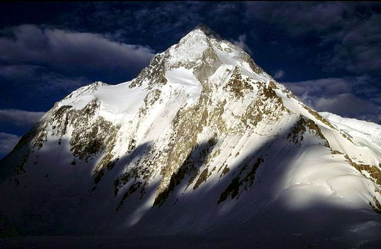
Gasherbrum I seen from the glaciers below C1.
Brief History
| Date | Team/Country | Notable Event |
| 1889-1929 | Italian and British. | Surveyors document, photograph and survey the Gasherbrum-group. British explorer William Martin Conway introduced the names 'Hidden Peak' and Gasherbrum II. |
| 1934 | Swiss Expedition organized by G.O. Dyhrenfurth. | The large international expedition explores Gasherbrum I and II peaks. Two climbers able to reach the height of 6300 meters. Caught in an extremely violent storm, the same as killed Merkl, Welzenbach aand Wieland on Nanga Parbat. |
| 1936 | French Expedition. Leader Henri de Ségogne. | Route of choice - south spur. Team reaches 6900 meters and had to give up after ten days of snowfall. A massive expedition which included 35 Sherpas from Darjeeling. |
| 1958 | American Expedition headed by Nick Clinch and sponsored by the American Alpine Club. | First ascent. Andy Kaufman and Pete Schoening. Interesting detail 1: The summit pair went along with makeshift snow-shoes made from crampons and plywood from food-boxes. Interesting detail 2: They used mirrors on the summit to tell their friends that they had reached the summit. |
| 1975 | Reinhold Messner and Peter Habeler.
Schnell, Schauer and Zefferer. |
2nd ascent. Reinhold Messner and Peter Habeler reach the summit via a new route which came to be known as the northwest route. First alpine ascent, inspired by the Austrian four men team success on Broad Peak. Only 200kg of gear in total and 13kg on the first day of climbing. Messner’s 3’rd 8000er.
The Germans led by Schnell summited one day after Messner and Habeler on the same route. |
| 1977 | Yugoslavian Team. Stremelj and Zaplotnik. | Fourth successful ascent by two Yugoslavs, again on a new route. A team member who tried a solo repetition (Drago Bregar) dies. South west ridge. |
| 1980 | French Expedition. Barrard and Norbaud. | Fifth Ascent. A French expedition summits via the south ridge for the first time, which included summiting Gasherbrum I Sud. |
| 1981 | Japanese Team. Azuma and Shimotori. | Japanese team makes the 6th successful ascent. |
| 1982 | German expedition headed by G. Sturm. | Team summits the peak via a new route on the north face. The same year, the first woman, Marie-José Valencout summits. First Pakistani to ascend (Mohammad Ali). |
| 1982 | Sylvan Saudan. | This magnificent mountain was host to the very first ski descent from the top of an 8000 meter peak. |
| 1984
|
Messner and Kammerlander. | The first traverse of two 8000ers. They first climbed Gasherbrum II, then went down to Gasherbrum Pass/La and continued to Gasherbrum I by a variant of the north- west face. Messner stated “only one out of 30 alpinists would’ve survived this climb”. Critics have pointed out that the pair descended to the place of C1 where they rested and also got support from a Balti HAP named "Little Karim" who, was with them for almost the whole climb. |
| 1985 | Escoffier.
Di Federico. |
Escoffier an impressive speed ascent. 21 hours, base-summit-base.
Di Federico made the first solo ascent. |
The first ever winter ascent took place in the winter of 2011/2012. Poles Bielecki and Golab reached the summit via the normal route in early March 2012. The expedition was lead by Polish legend Artur Hajzer.
Here's one brief report about the climb:
Poles climb Gasherbrum I in winter
Getting There

GI and climber seen from GII/GIII
Gasherbrum I is a long way into the wilderness in one of the most remote parts of Pakistan. Sooner or later you have to pass Islamabad as this is the town where you get the permits for the peak. If an organizer has taken care of the arrangements for you, you can just relax and follow your guide through the country. If you want to arrange everything yourself, the following may be of help.
From Islamabad to The Northern Areas. Local buses serve Islamabad with Skardu (the normal starting point for the trekking) well. Catch a bus from NATCO or Masherbrum Tours from Pirwadai i Rawalpindi (twin city of Islamabad, 15 km away). The cost for the 22-30h journey is about 12 US$. A taxi from central Islamabad will cost you 200-300 Rps. Some buses stop overnight in Besham, some go straight through to Skardu. If you have booked a ticket on a direct bus, don't be surprised if you have to wait in Besham for some time. Usually this wait is for other buses to gather and also for the police/military to ready a convoy. There are almost always some minor unrest in Indus Kohistan and to play it safe, the authorities arrange a convoy for the night traffic. It's nothing to worry about, it's standard procedure in this area.
From Skardu to Gasherbrum I. There are two routes to the peak from Skardu - via Askole or via Gondogoro Pass. The former is to recommend if you're not acclimatized. Gondogoro Pass is a mighty 5600m, so most trekkers and climbers use this route for the way back.
To Askole. A jeep ride takes 6-8h on partly miserable roads and the going price in the summer of 2005 was 3500-4000 Rps. In Askole you can either camp out in the wild or use the one of the camping places, which will cost you 100 Rps. Facilities includes toilets, running water and a grassy, walled camping area.
The first camp site along the route is Jhula. It takes anywhere between 4 and 8 hours to reach Jhula from Askole and the trek is very straight forward. Most of the time you walk on good paths along a river. An early start is recommended as it gets very hot in this area. Two bridges where you have to pay a small fee have to be crossed. Jhula has shower cabins, running water, toilets and camp platforms. 100 Rps./night.
Normally, there is not a problem to reach Paiju the second day. The trek is harder as you sometimes walk in sand along the rivers and there are some ups and downs en route. Paiju has the same facilities as Jhula and the cost to camp there is also 100 Rps./night. The place can be very crowded in the high season and if you don't like that, just continue for another 20 minutes to the first stream or to where the glacier start, where a very good place to camp is situated. Fresh water available here.
The next camping place is Urdukas, which has very good views of the Trango group. The camp site is situated on a hillside with good camp spots. Facilities and price is the same as Jhula and Paiju. If you want to go further or a part of the way to Urdukas, remember you'll be camping on the actual glacier. Campspots can easily be found there as well, but in some parts there are half an hour in between good or/and safe ones.
From here on the lenght of a normal day trip varies a lot depending on how the persons in the group feel. There are some camps along the way, but they are all very basic, consisting of shelters built of rocks. Most groups stop at Goro II, some stop an hour before this camp, Goro I and some go all the way to Concordia.
Concordia, the amazing glacial ampitheatre with four of the world's fourteen 8000+ peaks within a radius of 20 km. The place could be one of the most beautiful places on earth is sadly full of garbage and human waste. To the left you can see Broad Peak and K2. Ahead of you Gasherbrum IV is looming and to your right is the impressive Mitre. No fees and no facilities in Concordia.
Continue up along the upper Baltoro glacier. When heading out of Concordia, ask for directions as the route through some smaller serac fields aren't obvious. Ladders over some large crevasses here. Follow the glacier until you're at the southern reach of Baltoro Kangri and head north towards Sia Kangri. From here you see Gasherbrum I for the first time. If you're tired, there are some smaller camps along the way, notably Camp Moorr. No facilities here, but good shelter. There's also an army post along the way. Don't flash your camera here, it will be confiscated! About 4-7 hours of out Concordia, you'll hit the Gasherbrum I base camp, which is very spread out on a glacier ridge.
Gasherbrum I from the Chinese side Very few expeditions have tried to summit from the Chinese side. The base to start from is the oasis city of Kashgar on the brink of the Taklamakan desert. 270km of good asphalt road takes you to Yecheng. A junction is located 6 km out of the city at the little settlement of A-Ba. The road starting here is the famous Xinjiang Highway, which takes you all the way to Lhasa. The desert transforms into lower hills, which gets taller and taller and after half a day's travel you're surrounded by real peaks. The first pass at Aqmeqit is 3300m and is a very spectactular experience thanks to the ridiculous amounts of switchbacks. Pass Kudie and the start of the long climb to Chiragsaldi Pass begins. The pass is infamous for its rough and quick changing weather and is the place where you cross the Kunlun mountain range. From here, at 5000m, you'll have your first views of the Karakorams. A long steep descent takes you to Mazar, a ramshackle settlement on the banks of a huge river. This is where the roads towards Gasherbrum I ends and the trek begins.
Walking out via Gondogoro Pass
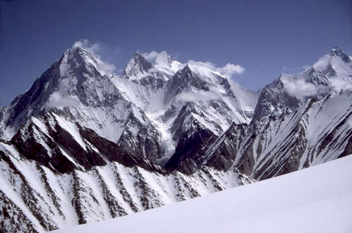
The whole Gasherbrum Group seen from Gondogoro Pass. From left to right: G IV, G III, GII, G V, GVI and GI. G VI is the ridge in front of G I.
Gondogoro Pass (or La in the local language) is sometimes stated to be the highest pass in the world and the altitude given on many maps is over 5900m. It's not that high, but at 5600m it's still a very impressive pass. Many teams choose to walk out this way because of the outstanding views from the pass-summit. Masherbrum (7821m) is very close and to your NW you see the whole Gasherbrum group (see photo above), Chogolisa (7665m), Baltoro Kangri (7800m) and a lot of other high beautiful peaks. To the north K2 and Broad Peak are visible. In the south the extraordinary Laila Peak can be seen.
From Concordia it's a long day's walk to Ali Camp. First you walk past Mitre Peak and head up the next valley/glacier on your right hand side. Coming from Gasherbrum I's base camp, there's an even longer day's walk. Try to get over the rivers early on the walk down the valley. Watch out for rock falls when entering the valley and try to gain access to the icy part of the glacier as soon as possible. Better to walk up there then down in the scree. When approaching Ali Camp, watch out for crevasses. The "security team" of Ali Camp will scream at you, where and where not to walk. Ali Camp has a 100 Rps./night fee. Ridiculous prices for "nature preservation" (there's loads of garbage all oer the place), "guiding services" (I never saw any guides when I walked over the pass) and "security" (some bad plastic ropes, attached in extremely bad way is to be seen close to the summit of Gondogoro Pass) has to be paid. For 1-3 persons it's 2500 Rps. For 4-8 persons it's 4500 Rps. The pass is privately owned. That is probably why this scam can go on as it does. My advice is to bugger the "guides" staying in Ali Camp about the garbage and not trusting the ropes at all.
I was told the it would take 5-7 hours to reach the pass from Ali Camp. It took me 2.45. For an acclimatized mountaineer, this is probably normal. It can be very windy on top of the pass, as it is a lot of elevation drop on the SW side. Don't trust the ropes on this side either. It's quite steep on this side (40-45 degrees). Stay up high on the right hand side if no tracks. There are glaciers in the middle of the glacier further down. The path gets really good before the little camp site of Xhuspang/Shispang, where you also can get very basic meals.
The glacier gets more difficult to travel after the camp and when you have passed the first rocky part and entered the main valley, stay to the left all the time. Doing so makes you avoid all the large crevasses and the left hand side is also the side you leave the valley on. When at the bottom of the first valley, take a left and enter some very nice meadows with yaks. Excellent views of sharp peaks. Some tricky, slide sections have to be passed. The walk gets easier again when heading down the lower part of the Gondogoro glacier towards Shaishcho. In this little settlement you can eat and pitch your tent under nice-smelling wild roses. 100 Rps./night per tent. From here it's a very easy 3 hour walk to Hushe. The Hushe - Skardu road is of awful condition for the first couple of hours. In the summer of 2005 the road had been badly cut away by a big river and all travellers had to walk over a wild river on small logs. Other jeeps were waiting on the other side. Lots of apricot orchards followed. From close to Khaplu the road is asphalt all the way into Askole. Count on 5-8 hours from Hushe to Askole.
Red Tape

In the icefall
Visas:
Visas are required for nationals from most European and English-speaking countries. Validity period and cost varies a lot depending on which passport you carry and where you apply for the visa.
Some Pakistani Embassies around the world
Visa extensions are available in most major cities in Pakistan, but should be avoided in the really large cities as it can be a long and nerve-wrecking experience. For Gasherbrum I climbers, Skardu is a recommended place for extensions. See also the Skardu section
Permits for Gasherbrum I - From the south side/Pakistan
You need a permit to climb the peak, which you can get hold either via the Ministry of Tourism or via an expedition agent. The fees were dropped to half of the old price some years back and the going prices for 2005 are as follow:
- K2's royalty fees: 6000 USD for a team of seven, 1000 USD each additional climber.
- All other 8000ers, Gasherbrum I and II, Nanga Parbat, and Broad Peak: 4500 USD for a team of seven, 750 USD each additional climber.
- 7500 to 8000 meters: 2000 USD for a team of seven, 250 USD each additional climber.
- 7000 to 7500 meters: 1250 USD for a team of seven, 200 USD each additional climber.
- 6000 to 7000 meters: 700 USD for a team of seven, 100 USD for each additional climber.
A trekking fee is also appliciable in the Gasherbrum I area. It's US$50.
If you join a commercial expedition you don't have to think about the fees for the liaison officer (LO) which is a must in this area of Pakistan. If you walk in via Askole, you need a LO all the way from the military checkpoint some hours out of Askole. If you choose the Gondogoro Pass/Hushe option you can walk in without a LO. If going independently, you're supposed to pay the salary for the LO. Here's the full story, which also give you info about the obligatory briefing and de-briefing. An environmental fee of $200 also have to be taken into account. There's a refundable bond of $6000 which most expeditions have to pay. Some doesn't, but to be safe than sorry and have money readily available if the demand is a fact.
If you attempt a peak lower than 6500m in this restricted area, a Ministry of Tourism approved guide has to be in your company. It's is much cheaper and straight forward than dealing with a LO.
Climbing fees are reduced and pro-rated if any expedition members are Pakistani citizens.
Permits for Gasherbrum I - From the north side/China
Permit prices in China are lower. The cost of a permit to attempt Gasherbrum's North side is now $1,760 for a group of up to 10 members ( + 1 or 2 leaders) and an extra 10% for each additional member. The walk in from the North, however, is considerably longer (10-11 days) and the price of pack camels may offset some of the price difference. Wild river crossings have more than once stopped expeditions alltogether.2010
Karrar Haidri, representing the the Executive Council Alpine Club of Pakistan forwarded me the following information.![A cold morning at 6700m on...]()
Cold morning
Government of Pakistan vide Notification. 1(1)/2002-OP, dated 15th October 2008. In suppression of all previous notifications regarding announcement of concessions for Mountaineering, Ministry of Tourism, Government of Pakistan has decided to continue reduction in royalty fee during the calendar Year 2010 as per details given below:
1. Zero royalty fee for peaks up to 6500-M.
2. 10% royalty fee on mountains situated in Chitral, Gilgit and Ghizer except on Spantik/Golden Peak.
3. 05% royalty fee on all peaks during winter season (December- February).
4. 50% discount on royalty fee on all peaks except as mentioned in (1) and (2) above as per following break-up:
The prices after reduction:
K-2 8611m $6000 for 7 member for additional member $1000
8001-8500m $4500 for additional member $750
7501-8000m $2000 for additional member $250
7001-7500m $1250 for additional member $200
6501-7000m $750 for additional member $150When To Climb
June to September is the normal climbing season. In the winter of 2011/2012 the first ever winter ascent took place. A Polish expedition reached the summit in March 2012.
Mountain Conditions
There are many expeditions going to Gasherbrum I and II and those share the same base camp. Many of them have satellite communication capability and are also online on a daily basis, i.e. you can get plenty of info about the weather. The K2 weather report also apply for Gasherbrum IV. Main site of Adventure Weather.com![Lenticular clouds starting to...]()
Clouds over the summit
The Pakistani army people on the Baltoro glacier keep a close check on the weather. Another good source of info, but let you LO make contact with the army base, as it’s not a good idea to walk up there by yourself.
Camping
It's allowed to camp anywhere along the route to Gasherbrum I. Most climbers who go to the area have bought a package deal from an organizer and therefore a high majority of campers stay in the official campsites along the way. Some of them are clean and well-equipped places, some looks more like garbage dumps (Ali Camp and Concordia) and some are only detectable by some spartan wind shelters built by piled up rocks.![The huge bulk of earth s...]()
GI seen from C1
Apart from the camps at Paiju, Jhula and Urdukas there is no reason to stay at the official places as they often are crowded and noisy places. Pitch your tent anywhere, but be careful with the water conditions close to places where many people camp or have camped.
In the main Gasherbrum base camp the liaison officers are very strict about where you camp. This is because of its sensitive location close to both the Indian and the Chinese borders. Normally you have to camp where the rest of your expedition and LO camp.Books
A book I can't link in the normal way from the List of books about Gasherbrum I is the French Expedition au Gasherbrum.
Porters
Contrary to what some organizers are telling you, you can arrange the trek all by yourself. The porter salary system was strict and worked fine until 2004, when massive amounts of climbers arrived for the K2 anniversary. A shortage of porters made some organizers desperate and they had to bid over the governmentally fixed prices. This created havoc and the whole porter salary system collapsed. The cost for a porter is now down to your bargaining skills. Officially it should be roughly 2850Rps. to Gasherbrum I base camp, but count on paying 4500Rps (excl. food for porters, otherwise 5500-6000Rps). Porters can be found in Askole, but if there are a lot of expeditions leaving when you get there, there is a high risk there are none available. Better book beforehand. The organizers are not very happy to help you out with this, as they want to include you in a group, but the small hotels in Skardu can usually help you. The price mentioned above is the full price, which include sunglasses, gloves etc. for the porter.![The broken glaciers on and...]()
Broken glaciers
What is not included in the price are the below items and you have to supply the group of porters with the following: - A kerosene stove
- Kerosene
- A tarp or a sheet of thick plastic which serves as a tent/shelter.
- Food All the above is best bought in Skardu. Food/porter 1100-1300Rps. The rest on the list 600Rps. (10 litres of kerosine).
Commercial Expeditions
There are a lot of companies which can offer you a package deal for all the higher peaks in Pakistan. Gasherbrum I is one of the more popular even if the lower Gasherbrum II attracts more climbers because of its lower technical difficulty. I choose to list the ones I personally have encountered on my journeys. Random order.
Local organizers
Hushe Treks & Tours Local organizer which has been around for a long time.
Nazir Sabir Expeditions Supposedly the best organizer, according to many Pakistanis. A bit more costly than the average organizer.
Karakurum Treks & Tours Another company with lots of experience and good reputation.
Karakurum Magic Mountains A quite new company with great services.
Karakorum Explorers Small but experienced company.
Saltoro Summits SP member Karrar's company.
Foreign organizers
Jagged Globe Base: UK.
Footventure Base: UK.
Tikmountain Base: Italy. Recommended!
Amical Base: Germany.
Useful addresses and information.
North Pakistan tours
Ishaq Ali Geologist
Po Box 463
Islamabad
Pakistan
Alpine Club of Pakistan Jinnah Stadium, Pakistan Sports Complex, Islamabad.PAKISTAN 44000 Tel: 92-51-9208963 http://www.alpineclub.org.pk/Skardu
Skardu is a little town where you'll spend a day or two and is the last outpost of "real civilisation". - You can extend your visa here, regardless of what some organizers tells you. Go to the DP (Deputy Comissioner) Office. It takes an hour or two to get the one month extension. Prices depends on your nationality. The DP Office is to be found in the nothern end of town, close to the K2 Guest House.
- There are plenty of hotels in Skardu. The top end places are K2 Guest House and Masherbrum Hotel. The former is known for it's cozy garden and the latter for over-priced food. Prices ranges in between 1500-2000 Rps./night. Cheaper alternatives are to be found along the main street. A good value hotel is Gasherbrum Hotel on the main street. 300 Rps./night for a large double is a good deal. The food in the hotel's restaurant is excellent and the portions are monstrous of size.
- Camping and mountaineering shops sells everything you can find in their equivalents in the west. Prices varies. Gas canisters for example are expensive, but down suits can be bought for 200US$! Almost everything here is second hand.
- Food shops. There are plenty of them along the main street. Don't expect to find much more than the staples.
- If you hire your own porters, you better buy the stuff they need in Skardu. Further up the valleys it'll be way more costly and it's not 100% you'll find what you look for. See the porter section for more details about this.
Basic Information About Pakistan
- For more information about Pakistan
- One of Pakistan's biggest newspapers online
- Pakistan's official site for tourism
Money & Costs
Currency: Pakistani Rupee.
141.60 Rps = 1 US$ in April 2019.
Relative costs:
Road side restaurants: US$ 0,5-1,5
Budget meal: US$2-3
Moderate restaurant meal: US$3-8
Top-end restaurant meal: US$5-10
Budget room: US$1,5-5
Moderate hotel: US$10-15
Top-end hotel: US$22 and up
By staying in hostels or dorms and eating like a local you can get by on as little as US$3-10 a day. If, however, you were looking for a moderate touch of luxury you could spend as much as $30-40 a day which could get you accommodation that included a satellite T.V., a desk, a balcony, and a spotlessly clean bathroom. As in any place you can spend as much as you like to live in the lap of luxury and stay in swanky hotels. It's worth noting that rooms and food are cheaper in the north than in the south.
Both travellers cheques and cash are easy to change throughout the country, but commissions on cheques can be high. Apart from top-end hotels most places won't accept credit cards as payment although you can often use them for cash advances at western banks. Facilities for validation seem better for Visa then Mastercard. Occasionally a tattered note will be firmly refused as legal tender, and often in the smaller towns the appearance of a 1000 or 500 rupee note will cause consternation and an inability to provide change so make sure you get some smaller notes when buying your rupees. A reliable place for using Visa/Mastercards (ATM and cash withdrawals) is the Citibank in the Blue Area in central Islamabad.
Tipping
Baksheesh isn't so much a bribe as a way of life in Pakistan. It can apply to any situation and is capable of opening all sorts of doors, both literal and metaphorical. Anything from a signature on a document to fixing a leaking tap can be acquired through the magic of baksheesh. Most top-end hotels will automatically add a 5-10% service charge to your bill so any extra tipping is entirely up to you. Taxi drivers routinely expect 10% of the fare, and railway porters charge an officially-set Rs 7. The only time that a gratuity might not be welcome is in the rural areas where it runs counter to Islamic obligation to be hospitable.
As everywhere else, make sure the tip is not over the top. It only makes it hard for both future travellers and the locals. Be sure to read the situation right before using the baksheesh way. Some officials and army personal can be very touchy and it can really backfire offering the wrong person a baksheesh.
Bargaining
If baksheesh is a way of life, bargaining is a matter of style, particularly in the many Pakistani bazaars. Unlike the western hesitancy for bargaining, shopkeepers in Pakistani love to bargain as long as it's done with style and panache. Bargaining usually begins with an invitation to step inside for a cup of tea followed by a little bit of small talk, a casually expressed interest by yourself in a particular item, a way-too-high price mentioned by the seller, a way-too-low counter offer by yourself and eventually, after much comic rolling of eyes, a handshake and mutual satisfaction for both parties. Bargaining should always be accompanied by smiles, good humour and an ability not to get fixated on driving the price into the ground.
Climate in the different provinces
The best time for travelling to Pakistan depends on which part of the country you intend to visit. Generally speaking the southern parts of Pakistan including Sind, Baluchistan, Punjab and southern NWFP are best visited in the cooler months between November and April. After that it gets uncomfortably hot. The northern areas like Azad Jammu Kashmir, and northern NWFP are best seen during May to October before the area becomes snowbound. The weather may be a little stormy during this time but the mountain districts are usually still accessible.
Ramadan
Try and avoid Pakistan during Ramadan, the Muslim month of fasting which, usually occurs sometime during the months of December to early January. This is because a fasting Muslim is an understandably cranky Muslim, and you may find yourself involuntary joining in the fast because activity is kept to a minimum and food is hard to find during daylight hours. Pakistanis are usually very understanding when it comes to westerners who aren't muslims. Even if there are no tea or food served to muslims, these items are most of the time readily available for believers in other faiths.
Security
The security situation in Pakistan deteriorated through 1997, with areas previously considered safe experiencing the same sort of violence and crime as in the long-troubled Sind region. As well as the danger of being caught up in sectarian skirmishes, travellers have been the specific target of violence in Karachi and Lahore.
Sind, the region in the south of Pakistan which includes Karachi, was known as the `Unhappy Valley' or the `Land of Uncertainties' by ancient travellers. Switch to the present day and news of curfews, foreign kidnappings and atrocities between the two main ethnic groups - Sindhis, the province's indigenous inhabitants, and the Mohajir, Muslim refugees from India - suggests its former name is still not out of place. With robbery, smuggling and gun-running amongst Sind's biggest industries, the province remains a highly dangerous place to visit.
Travel to Sind as well as to the North-West Frontier Province, Punjab and Baluchistan should be undertaken with caution and only after consulting a national foreign affairs department prior to departure or a consulate in Karachi for current information. Many low end hotels in Lahore are infamous for theft from the rooms.
The Northern Areas are usually very safe and out of a climbers point of view this is the most important issue. The worst you probably encounter is snotty kids throwing a rock or two and a really annoying feature is the "one-pen-kids". Please do not encourage this behaviour by handing out gifts willy nilly. It only creates greed, beggary and a hell time for forthcoming travellers. If you want to give pens, hand it over to the local teacher/local.
Health
Shots against dengue fever, hepatitis A, malaria and, in rural areas, Japanese encephalitis are recommended. The tap water should be avoided all over Pakistan. Giardia and amoebic dysentery is endemic all over the country and Flagyl (metronidazole) is one of the more essential drugs to bring.
Miscellaneous
Time: GMT/UTC plus five hours
Electricity: 220V, 50 Hz
Weights & measures: metric
Tourism: 424,000 visitors
Photos - North/Chinese Side
Photos from the north side of the peak. Shot during a reconnaissance expedition in 1983 by SP-member John Shen. In the team were amongst others some well-known climbers; Kurt Diemberger and Jozef Raconcaj.
![]()
![]()
![]()
![]()
![]()
Credits
Thanks to Vertx the former maintainer of this page.
External Links
- Short history on Gasherbrum I
- A routes overview on JP Lafaille's site.
- www.jasminetours.com/gi
We run annual trips to Gasherbrum I, II, Broad Peak, K2, Nanga Parbat and Spantik.


Damien Gildea - Mar 17, 2006 7:39 pm - Hasn't voted
Red Tape / LOJust to clarify a bit: - all expeds to peaks over 6500m need an LO - if you have an LO, he joins you in Islamabad and goes to and from the mountain with you, whichever way you walk in. - it is illegal for the leader of an exped to leave the exped before it is over. ie. before he has gone back to Islamabad with the LO for the debriefing. - all expeds to peaks over 6500m require the US$6000 deposit for helo rescue. This has been the case for many years. A rescue insurance policy is not enough and nearly all embassies will NOT guarantee payment for you. Askari Aviation take your money and hang on to it while you are in the mountains. If you don't need rescuing, you just come back and get it. There's never been a problem getting money back if there was no rescue. - the deposit is usually taken care of by guiding companies and agents, which is why some climbers get a shock when they try to organise something themselves. - if you are just trekking in a restricted area, like the Baltoro, you only need a registered guide, no LO - same with climbing on sub-6500m peaks - the Hushe area used to be un-restricted, but as of a few years ago it is now restricted, so you officially need either a guide or LO to go beyond Hushe village, over to the Baltoro or elsewhere D
Corax - Mar 20, 2006 8:19 pm - Hasn't voted
Re: Red Tape / LOThanks for the input. Comments on the above post. Just to clarify a bit: - all expeds to peaks over 6500m need an LO Yes. - if you have an LO, he joins you in Islamabad and goes to and from the mountain with you, whichever way you walk in. The LO may join you in I-bad, but you can also hook up with him in the place from where you "need" him, for example in Skardu. You can also walk out via a restricted, but "non-LO-necessary area". A guide is then with you. - it is illegal for the leader of an exped to leave the exped before it is over. ie. before he has gone back to Islamabad with the LO for the debriefing. True. The only exception is in case of illness and in that case the leadership of the expedition has to be transferred to another person in the group. - all expeds to peaks over 6500m require the US$6000 deposit for helo rescue. This has been the case for many years. A rescue insurance policy is not enough and nearly all embassies will NOT guarantee payment for you. Askari Aviation take your money and hang on to it while you are in the mountains. If you don't need rescuing, you just come back and get it. There's never been a problem getting money back if there was no rescue. This issue was never even mentioned to me. I heard about other expeditions being asked for the deposit, but to my knowledge, no one in the team I joined put down the deposit. I was told I may be asked for an insurance that covered heli rescue, but that never happened either. - the deposit is usually taken care of by guiding companies and agents, which is why some climbers get a shock when they try to organise something themselves. True. One gang had never heard about the issue and didn't have the money for the deposit. They had to change target. - if you are just trekking in a restricted area, like the Baltoro, you only need a registered guide, no LO Yep. - same with climbing on sub-6500m peaks Yes. - the Hushe area used to be un-restricted, but as of a few years ago it is now restricted, so you officially need either a guide or LO to go beyond Hushe village, over to the Baltoro or elsewhere A guide is enough. The rules are according to two LOs very unclear about this. They said you officially don't need either a guide or an LO for this route. The "rescue team" based closed to the Gondogoro La may stop you though, even if the don't have the right to do so according to "the military book of law". Last year the LOs in the Baltoro area were very upset about the fact that the commercial organizers (specifically one of them) left a lot of responsibillities to the LOs. They sent guides up with the group, but in order to use this guide for other tasks, he left after arrival. Sometimes LOs had to "guide" a group out of the area on trails he had never visited. The bottom line is of course to double check all issues and rather expect the hard line Damien posted than basing them on the comments I made. I just wanted to let you know about my experiences in 2005.
Damien Gildea - Feb 26, 2007 12:55 am - Hasn't voted
BaltiJ, Re: the Kammerlander/Messner traverse, it was the Balti porter 'Little Karim' who was with them, not a Sherpa. D
Corax - Feb 26, 2007 2:19 pm - Hasn't voted
Re: BaltiThanks for pointing this out. I will re-read the info in the climbing history table once more. Most of it isn't my info, but a rest from former maintainers. J.
Shahid Hussain - Apr 20, 2019 4:06 am - Hasn't voted
Updated informationThank you Corax for the great information about Gasherbrum I. I have noted that this article was written in 2003. There are so many changes took place during the last 19 years period. For 2019, Royalty fee for GI is, USD $5400 for 7 members group, USD $ 900 Per additional person. Environment Fee/Waste Management Fee will be 68 US$ for each member of mountaineering expedition. Currency: Pakistani Rupee. 141.60 Rps = 1 US$ in April 2019. Flight from Islamabad To Skardu is very frequent. Pakistan International Airline is operating an Airbus PK451on daily basis. From Islamabad To Skardu is now only 20-22 Hours drive via Babusar Pass or via Karakoram Highway. It would be wise to contact a local Tour Operator to organise the trip, Documentations and get up to date information. One of the oldest and Government licence Tour Operator from Skardu is Trango Adventure. they will be happy to provide the Latest and up to date informations. info@trangoadventure.com https://www.trangoadventure.com