
|
|
Mountain/Rock |
|---|---|
|
|
42.69707°N / 0.04463°E |
|
|
Hiking, Mountaineering, Mixed, Scrambling |
|
|
Spring, Summer, Fall |
|
|
9383 ft / 2860 m |
|
|
Overview
 Pico Pineta & Marboré lake
 Marboré lake & Monte Perdido
A beautiful summit doesn't have to be necessarily high. Amongst the satellites of the famous Monte Perdido, one of them deserves to be mentionned as its finest viewpoint. Pico de Pineta, called logically Pic de Pinède in the other language, as it lies on the border, offers the most beautiful view to the glacier of Monte Perdido, overlooking the beautiful blue lake of Marboré.
The route from Spain visits the magnificent Valley of Pineta, and the famous route via the Balcon de Pineta. Seen from downside, together with Punta Forcarral (much more difficult), these twin peaks appear like two terrifying dolomitic jagged teeth, and attract inevitably the mountainners.
The other route from France, via the Cirque d'Estaubé, not less interesting, is a legend of the "Pyrénéisme" (pioneers as early as Ramond took it during 18th), and the stunning views of the Monte Perdido, via the Tuquerouye breach, making a sheer contrast from the greenness to the raw nudity, have taken away the breath of generations of explorators (at this time, most of them persuaded that Monte Perdido was the highest of the range)
Peak Pineta certainly takes its name from the eponym valley, itself probably named after the dense vegetation of pines. The first ascent is not precisely known, but for a long time this peak certainly remained in the shaddow of Monte Perdido, hence was not so interesting for visitors.
 Pineta Valley, with Pineta and Forcarral peaks on the right
 Gloriettes lake
Getting There
 Pineta car park
 Gloriettes lake
 Pineta valley
 Pineta valley
 Pineta valley
 Pineta and Forcarral before the storm
* French trailhead: Leave the A64 at the level of Tarbes, and hear to Lourdes, Gèdres and Gavarnie. Before Gavarnie, take in Gèdre the direction to the dam-lake "Lac des Gloriettes", in the "Cirque d'Estaubé" (the middle valley located between Gavarnie and Troumouse).
* Spannish trailhead: From Lerida, take the direction of L'Ainsa, and the tunnel to the french border. In Bielsa, take the junction to the valley of Pineta (rather take the upper juntion in the village than lower and crossing all the narrow steets of the town). After having struggled with the crowds of french tourists agglutinated near the discount shops, drive the valley to the end and park at the Parador de Pineta.
Going from one country to start in the other is possible also, but really practical only for the French, via the Bielsa Tunnel. The Spannish will have to make an important diversion as far as the french piedmont to reach the Gavarnie valley...
View Larger Map
 Pineta and Forcarral in the foehn Pineta and Forcarral in the foehn |
 Estaubé valley Estaubé valley |
Routes
 Estaubé valley
 Tuquerouye & Pineta seen from Perdido
 Tuquerouye & Pineta seen from Perdido
 Pineta route
 Pineta route
 The Monte Perdido over Lake of Marboré
* French route : Walk up the magnificent valley of Estaubé straight to the end. Near the end, instead of following the bottom of the valley, the trail elevates on the west slope to gain some height.
We leave Port de Pineta on the left, and Hourquette de Pailla on the right, to reach the foot of Brèche de Tuquerouye.
The climb is long, steep, and not really comfortable, on a long slope of screes. Out of the season, the snow can complicate it.
On the top of the corrie, you can climb additionally the small peaklet "Borne de Tuquerouye", which provides a nice overview of the Estaubé valley against few scrambles.
At the Brèche de Tuquerouye, you discover the unguarded mountain hut (likely to be used and crowded such the place is famous), as well as the stunning view to Monte Perdido and the Marboré lake.
We need to go down slightly in the direction of the lake to catch a more friendly slope leading East, to reach the south base of the Pic de Pinède. From now, there is no precise route to the top; the whole south slope is correct enough to make our way to the top, whatever are the gaps or outcrops we avoid here and there. Then we reach the top, with stunning views all around.
* Spanish route : Most of the route is pretty similar to the Balcón de Pineta route already described for the peak Astazou, a close neighbour. The only difference is that instead of heading to that one, we turn right earlier to catch the south slopes of Pico de Pineta, the same way as described for the french route. Note: it involves a serious scramble grade II difficult in one point, better descended with a rope (see picture below in the end).
 Pineta route
Red Tape
 Pineta route
 The stony shelter near Marboré Lake
Both sides of the peak, the french and spanish ones, lie in their respective national parcs, with their similar regulations (french and spanish). Basically, no trash, no wildcamping (however bivouac tolerated far from the roads), no flower picking...
Don't throw stones from the top. South, they will slide down to the heads of forthcoming hikers, North, they will land on french tourists deep below.
Do this trip absolutely by dry weather.
Bivouac / Accomodations
 Beautiful flora in the area...
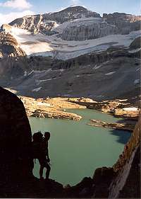 Marboré Lake from Tuquerouye
 Marboré Lake from Tuquerouye
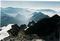 Pineta valley
 scramble on the Pineta route
* Wild camping
As mentionned above, try to bivouac only in subalpine area, where not visible. Choose preferably the Balcon de Pineta, near the Marboré lake. South from the lake, few mention a basic shelter under a flat rock.
* Huts and hikers hotels.
Let's first mention the non-guarded but famous refuge of Tuquerouye, a legendary place to stay for this route.
Lower in the valley, for a start late in the evening, there is the small hut of Estaubé
Not really on the route, behind the Hourquette de Pailla, are located both the guarded moutain hut of Les Espuguettes and the small shelter Cabane de Pailha
A hiker's basic guesthouse is well located in Héas, not far from the trailhead : Auberge de la Munia
On the spanish side, let's mention the historical Parador de Pineta, a hotel with quite high standards, but next to it is also located the Refugio de Pineta, with hikers facilities.
The Cabaña de la Estiva, a basic unguarded hut, is located a bit higher on the Pineta route. Another one, Cabaña de La Larri, is located on the trail to the Larri waterfall, not far.
* Accomodation in the valleys / official campsites :
Check the tourist boards of :
- The Bielsa valley : http://www.lospirineos.info/pineta/bielsa.htm
- The Gavarnie valley : http://www.gavarnie.com