
|
|
Mountain/Rock |
|---|---|
|
|
42.76176°N / 0.13681°W |
|
|
Hiking, Mountaineering, Mixed, Scrambling, Skiing |
|
|
Spring, Summer, Fall, Winter |
|
|
10335 ft / 3150 m |
|
|
Overview
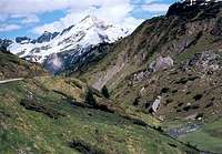
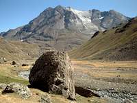 Vignemale group from the south. The Tapou is the first peak on the right.
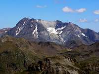 Vignemale group from the south. The Tapou is the first peak on the right.
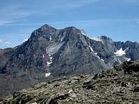 Another shot where Tapou stands on the right
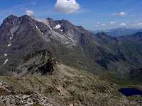 Another shot where Tapou stands on the right
 Tapou from Oussoue
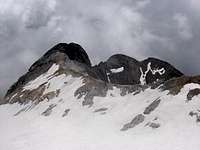 Tapou behind Montferrat
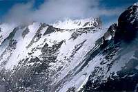 Montferrat and Vignemale from Grand Tapou
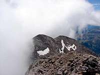 Grand Tapou summit in summer
The Tapou peaks, respectively Petit Tapou and Grand Tapou, are two tops of the Vignemale group.
While the small one is anecdotic and makes only a landmark on the route, the main one is a famous three-thousander of the Pyrenees. Another top named is called "Tapou du milieu", and is just the fore-summit of the main.
From a global perspective over the Vignemale range, the prominence of the Tapou is not so obvious, and many would state it is only a bump in the continuity of the Montferrat East ridge.
But here we are, unlike the Vignemale-Montferrat average level, this portion of the ridge is usually unaccessible to hikers. For the story, it is a famous rock-climbing route on excellent rock, accomplished for the first time by H.Brulle, C.Passet, F.Bernat-Salles in 1890.
This explains why the Grand Tapou is so "individualized" from the rest, out of topographic considerations, and why most mountaineers tend to access the Tapou peaks via the opposite way, from the bottom of the Oussoue valley, where the elevation is gradual and makes it a hiking goal.
This graduality is the other reason why Grand Tapou is so famous, as it makes a renown skitouring route in winter, making the Tapou a popular three-thousander for skiers.
The first ascent of Grand Pic de Tapou took place on August 1st of 1883, by Henry Russell, and the guides Haurine and Pierre Pujo.
This fact is interesting as the first ascent inaugurated also the first use of the name "Tapou" to designate these peaks, formerly unnamed. Russell pointed out the necessity to name those new conquests, and reviewing the toponymy of the terrain with his fellows, they commonly agreed to name them after the Tapou waterfall just below in the valley, over the Oussoue dam.
 Tapou peaks in the foreground Tapou peaks in the foreground |
Getting There
 Tapou & Montferrat in evening
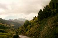 Oussoue road
Despite the top of the Grand Tapou lies on the border, there is no commonly used route to reach it from Spain. However, as stated later, one can consider the Bujarelo option.
But the most commonly used trailhead is the route in the Oussoue valley, accessible from Gavarnie, and usual trailhead for the Vignemale as well.
Route
 Oussoue valley
 Oussoue valley
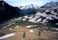 Walking in the direction of Pic Pointu
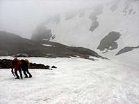
 The ascent of the Tapou peaks
 Pics de Lourdes
 Pic Rond and Pic Pointu
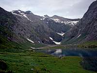
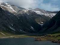
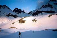 Near the lakes of Montferrat
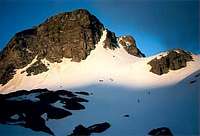 Pic Pointu in the morning
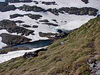 Montferrat lakes
 Final ridge
 Gavarnie seen in the morning
 descent
1/ French side
The route from Oussoue consists in elevating south just before reaching the Oussoue dam, after the Milhas hut, via the the hollow of La Canau that we follow on the right shore.
Just before reaching a hut named "Cabane de Lourdes" (not to mix with the town !), we head West in the direction of the well-named round shaped "Pic Rond", that we pass under its right slope.
Another evocatively named peaklet appears, "Pic Pointu", as sharp as the other was round. We also pass it under the right slope, north.
Circumventing it, we reach the lakes of Montferrat, usually hidden during winter. Then we head north in order to reach a corrie oriented to the West, that reaches the top of Petit Pic de Tapou.
This peaklet is not a three-thousander yet, 2923m, but offers a first glance over the border (non mandatory).
The promontory overlooking the border, Tapou du Milieu, is reached next, then we get to Grand Tapou by keeping elevating over the SE gentle slope, keeping the route as wide and high as possible.
2/ Spanish side
In the Bujarelo, one can reach the pass Port du Pla d'Aube, on the slope located between the two streams of Barranco Salte and Barranco Salte and Barranco Planobe.
Then the french route is caught back just over the Pic Rond. I have never been in the area but Rafa gave an interesting feedback about this option :
"The Spanish route is quite long, 6h30 in total. The normal ascent route is from the Cabaña de Ordiso in Bujaruelo, and the Collado de la Plana de Alba (spanish name of Pla d'Aube)."
Camping
 Struggling with the elements :)
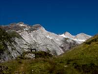 Oussoue hut in front of Grand Tapou
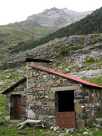 Cabaña del Cerbillonar
 First steps on the trail
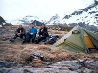 Bivouac under Pic PointuTapou, Montferrat, Chausenque, Pt Vignemale
* Wild-Camping, bicouacking :
The wide grassy immensities over the Oussoue valley offer unlimited possibilities. We are in the national park but this area is not very visited, and there was never such problem, as long as we camp over the tree line far from the road.
* Non-guarded huts, shelters :
This is a very good question because the area has few of them, but no guarded mountain-huts.
- The Cabane de Milhas on the border of the Oussoue road is private and locked by key. Neither the Cabane d'Oussoue earlier on the road.
- The Cabane de Lourdes is the best located hut on the road to the peak. In good state. 4 matresses, but can contain 6. Good chimney.
- The Cabane de Sausse Dessus , in much poorer state, is the closest alternative, despite a bit apart from the route, if the other is full.
- In Spain, the Cabaña del Cerbillonar, whose location is not precisely known, should be located not too far from the route reaching Port du Pla d'Aube
* Hotels, accomodations : the world-famous resort of Gavarnie is full of them...
 Oussoue lake Oussoue lake |
 Oussoue lake Oussoue lake |