
|
|
Mountain/Rock |
|---|---|
|
|
42.64180°N / 109.094°W |
|
|
Sublette |
|
|
Hiking |
|
|
Summer |
|
|
12356 ft / 3766 m |
|
|
Overview
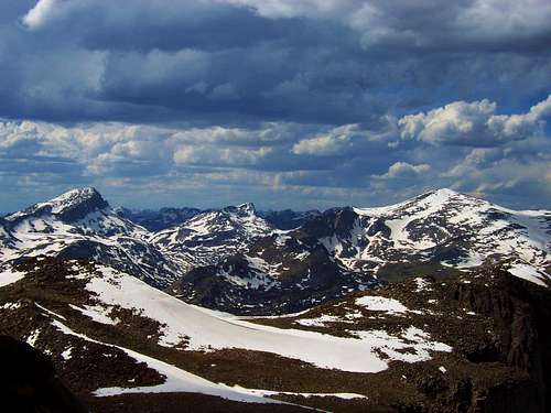
Mount Nystrom is located in the southern portion of the Wind River Range and right on the Continental Divide. It is one of the most easily accessible 12,000 foot peaks in the entire range; with round trip hiking distances ranging from 10-14 miles. Unlike many parts of the Wind River Range, Mount Nystroms’ slopes are gentle and there are no glaciers on this mountain. Nonetheless, Mount Nystrom is a worthy destination and because of its prominence views are excellent. If you are looking to avoid crowds, Mount Nystrom is a good choice; the Sweetwater River trailhead has some of the least used trails in the range. Mount Nystrom & Larsen Creek
The route from the Sweetwater River trailhead to the summit is scenic, passing through a forest that was burnt down years ago, which is now coming back to life; to the mellow southwest ridge of Mount Nystrom with great views. An area plentiful with wildlife; many deer and elk were seen on the way to the summit.
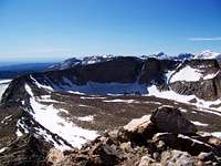
From the summit of Mount Nystrom, you will have excellent views of the Wind River Range to the north and east. Looking north you will have good views of Temple Peak, East Temple Peak and Wind River Peak will be the three most noticeable peaks. Looking east you will see Atlantic and West Atlantic peaks, in the very southern tip of the range. On a clear day, looking west you will be able to see the “flat topped” Wyoming range about 75 miles away.
Mount Nystrom has 1816’ feet of prominence and comes in at #44 for Wyoming peaks with the most prominence. Click here for Wyoming’s top 100 peaks with the most prominence.
*Added by jimmyjay
-Nystrom was named in 1877 by F.M. Endlich (on the Hayden Survey) for his wife's family.
-Nystrom is geographically of interest because at this point the Continental Divide leaves the crest of the range, entering the Great Divide Desert while the crest of the range skews into the Sweetwater drainage.
Getting There
 Temple, East Temple & Wind River peaks
Passenger cars will be able to make it to the Sweetwater Guard Station, which is 2 miles from the trailhead, the next 2 miles is very rough and most people will not want to drive their cars all the way to the trailhead, however, I was able to drive my Mazda within a ½ mile from the trailhead with no problems (didn’t even scrape), the next half mile had some large rocks that even some high clearance vehicles will hit.
From Salt Lake City (278 miles) :
Head east on I-80 towards Rock Springs, WY at Rock Springs, take US highway 191 north towards Pinedale. Heading north for 39 miles to Farson, WY, take a right on highway 28 and head east for just over 33 miles to the Lander Cutoff Road. Take a left on the Lander Cutoff Road and follow signs for the Sweetwater Gap Ranches and Sweetwater Guard Station. Heading north on the Lander Cutoff Road for 14.5 miles you will reach the Sweetwater Gap Road. Take a right and drive 7 miles following signs for the Sweetwater Guard Station, bear left at the next the next junction and shortly arrive at Sweetwater Campground. Go left again on Forest Road 890 (the rough 2 miles road to the trailhead)
From Pinedale, WY (64 miles) :
Drive south on US Highway 191 for 12 miles. At the town of Boulder turn left on Wyoming Highway 353 and drive 18 miles to the end of the pavement. Shortly after the pavement ends, go strait through the junction and drive south crossing the Big Sandy River (Buckskin Crossing Historical Marker). At next junction after the crossing, bear right and continue on main road bearing left at next junction. Turn left (east) at following junction (signed for White Acorn and Sweetwater Gap Ranches), and drive 7 miles. Following signs for the Sweetwater Guard Station, bear left at the next junction and shortly arrive at Sweetwater Campground. Go left again on Forest Road 890 (the rough 2 mile road to the trailhead).
When To Climb
 Mount Nystrom from Atlantic Peak
The best time to visit the peak would be mid June-September during a normal snow year. Snow on the southwest ridge will melt off rather quickly because of its direction. However, snow may linger on the summit ridge; there are several bumps which you will go over near the summit.
The southwest ridge isn’t steep enough to require ice axe or crampons (unless under icy conditions) and avalanche danger would be almost zero on this slope, it would make a good winter hike, but the approach could be much longer.
Camping
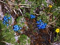 Alpine Forget-Me-Nots
The Sweetwater campground is located by the Sweetwater Guard Station, right before the road turns rough for the last 2 miles to the trailhead. This campground is small and busy for being in such a remote location, with nightly fees.
If you are looking for primitive camping, there are many nice spots, I found a nice one up the road towards the trailhead, right before I couldn’t go any further, there was a pullout to the right which extends 50 yards from the trailhead road and ends at a camp spot right above the Sweetwater River. There are a few other primitive camping spots that exist below this one and by the trailhead there are several spots next to the river.
Red Tape & USGS Quads
 View east towards Atlantic Peak
Mount Nystrom and the mentioned trailhead is in the Bridger-Teton National Forest. Please follow wilderness area rules.
Pinedale Ranger District
29 East Fremont Lake Rd.
P.O. Box 220
Pinedale, WY 82941
307-367-4326
Fax: 307-367-5750
Mountain Conditions
 Mount Nystroms summit
A predicted forecast for the area can be found here.
Local weather for Farson, Wyoming can be found here.