
-
 48137 Hits
-
 87.31% Score
-
 24 Votes
|
|
Mountain/Rock |
|---|---|
|
|
44.48970°N / 110.1403°W |
|
|
10568 ft / 3221 m |
|
|
Overview
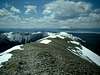
Avalanche Peak is located on the eastern border of Yellowstone National Park, and adjacent to the Shoshone National Forest on the east. The peak is part of the Absaroka Mountain Range. New USGS quads and other maps now list the elevation of the peak at 10,568 ft., but many older maps and publications list an elevation of 10,566 ft.This is one of the most popular peaks (by far) in the state due to its National Park designation, constructed trail, and the relatively high trailhead access. The bowl is a popular glisse area in recent years. The peak is often climbed as part of a ranger-naturalist guided hike during the summer tourist season.
This is a relatively short (i.e. ±4 hour round-trip) hike which offers what is arguably one of the best views in the park. The peak overlooks much of the eastern side of Yellowstone and the surrounding forest to the east, and also offers outstanding views of nearby Yellowstone Lake. Elevation gain for the ±4 mile round-trip hike is 2,100 feet.
USGS Quad:
 |  |  |
Getting There
Yellowstone National Park occupies the northwest corner of Wyoming, as well as small portions of southern Montana and eastern Idaho. There are five major roads entering the park:The North entrance at Gardiner Montana is the only entrance which remains open during the winter. Refer to the Operating Hours & Seasons page for complete details on road opening and closing dates in the park.West Entrance - Highway 20 through West Yellowstone, MT
North Entrance - Highway 89 through Gardiner, MT
Northeast Entrance - Highway 212 through Cooke City, MT
East Entrance - Highway 20 through Cody, WY
South Entrance - Highway 89 through Grand Teton NP
Additional information can be found on the Yellowstone Plan Your Visit web page.
Avalanche Peak is is climbed via the Avalanche Peak Trail, which begins from the road between Fishing Bridge Junction and Yellowstone's East Entrance. To reach the trailhead drive ±20 miles east from Fishing Bridge Junction, or ±8 miles west of the East Entrance. The trailhead is located on the north side of the road. There is no designated parking on the trailhead side of the road, so park in the picnic area on the south side of the road, near the west end of tiny Eleanor Lake. Refer to the route description for details on ascending the peak.
Additional 'Getting There' information courtesy of SP member jimmyjay: The east entrance road is under construction this year (2005-2006). It tends to be closed more than the website says. General policy is: OPEN 8am-8pm with up to 1/2 hour delays. Delays actually run closer to 1-3 hours once traffic is let through, at which point traffic through the trailhead area is bumper to bumper. The best bet for the schedule is to call (307)344-2117. IMO - this peak is best climbed in May or June and avoided during peak season (July-Sept) this year.

Red Tape
Yellowstone Entry FeesEntering Yellowstone National Park requires purchase of a $25 7-day pass, available at any of the five entry stations entering the park. This pass allows entry into both Yellowstone and Grand Teton National Park to the south. Alternatively, an annual America the Beautiful - National Parks and Federal Recreational Lands Pass may be purchased for $80. This pass provides access to, and use of, Federal recreation sites that charge an entrance or amenity Fee, for a period of one year.
Backcountry Permits
A backcountry camping permit is required for all overnight trips into the Yellowstone backcountry. Backcountry camping permits may be reserved in advance, and require a $15 fee. Backcountry permits may also be obtained on a walk-in basis, (subject to availability) no more than 48 hours prior to the hike - there is no charge for walk-in permits.
Permits may be obtained from most ranger stations in the park. When picking up backcountry permits you will be required to view a short video on regulations and safe travel in the Yellowstone backcountry. The Yellowstone Backcountry Camping & Hiking page contains complete details and regulations on backcountry trips in the park.
 |  |
Camping and Lodging
There are numerous options for camping within Yellowstone National Park. Regulations and available facilities varies among the campgrounds. Visit the Campgrounds in Yellowstone page for complete details.There are also a number of lodging facilities within the park, ranging from rustic cabins to luxurious lodges and inns. Lodging in Yellowstone is administered by Xanterra Parks & Resorts, the primary concessioner in Yellowstone. Refer to their website for complete details on locations, reservations, etc.
There are no backcountry camping spots in the immediate vicinity of Avalanche Peak.
Bear Precautions
Both grizzly and black bears are found in the park. Several of the most important precautions for safe travel in bear country include the following:Visit Yellowstone's Minimizing the Dangers of a Bear Encounter web page for additional information on hiking in bear country.
When To Climb
The most common time to climb Avalanche Peak is from late May or early June through October, although this may vary considerably depending on snow conditions. For a completely snow-free hike plan on waiting until at least early July.Winter attempts of Avalance Peak will involve considerably more effort, particularly just to reach the normal summer trailhead. This is a difficult part of the Absaroka to reach during the winter; Sylvan Pass is also one of the snowiest spots in the state, due to its upslope orientation and proximity to Yellowstone Lake. Access by snowmobile is complicated by the current ban on private sleds, which limits snowmobile traffic to guided groups only. While an approach by skis or snowshoes is possible, this would entail a long multi-day approach.
Weather and Climate
Yellowstone's weather is characterized by its unpredictability. Always be prepared with warm clothing and rain gear, even on warm and sunny summer days.Weather related links: