

-
 22163 Hits
-
 93.81% Score
-
 44 Votes
|
|
Area/Range |
|---|---|
|
|
42.69200°N / 0.51880°E |
|
|
Hiking, Mountaineering, Scrambling, Skiing |
|
|
Spring, Summer, Fall, Winter |
|
|
10571 ft / 3222 m |
|
|
Overview
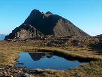
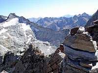 Seil de la Bacque from Gourdon
Here were located the longest glaciers, some centuries ago: Russell often affirmed "one can walk here several kilometers on ice", despite Beraldi teased the habit of his fellow to always look at the glaciers with the "eyes of imagination". Nowadays, their remains make some of the largest Pyrenean french glaciers after Vignemale's Oussoue.
 The Haut Luchonnais from Pic d'Estos
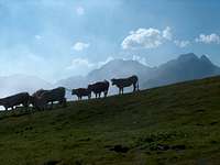 Cows with Hourgade in the distance
 Vallée du Louron
These parts of the French mountainside are commonly called Luchonnais (Haut and Bas Luchonnais, "high and low"), after the local and historical mountain spa of Bagnères-de-Luchon: Formerly a high place of French mountaineering, headquarters of Pioneers like Franz Schrader, Maurice Gourdon, Toussaint Lézat, Jean Arlaud, Hilaire Belloc, or more recently Robert Ollivier and Louis Audoubert, after who were named several peaks of the region.
 Bas Luchonnais from the Mont-Né
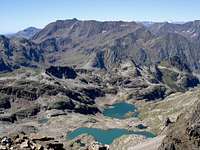 Bachimala from Belloc
 Litérole-Perdiguère ridge
 Spanish peasants crossing the border
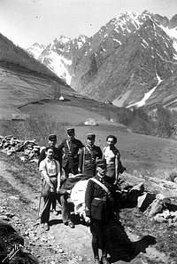 Spanish refugees crossing the border, during WW2
 Spanish refugees crossing the border, during WW2
This area, as defined on Summitpost, corresponds roughly to the French departement of the Haute Garonne (31), to which we would append the two valleys of Aure and Louron, whose "Nestes" (local name of a river), are tributaries of the Garonne, unlike the rest of the Hautes Pyrénées (65) which flows into the Adour and forms the Bigorre. Which explains the presence of the "Pays des Nestes" in the area name.
Despite the whole area does not have any direct connection with Spain, being a "cul-de-sac" between the Bielsa tunnel west, the Vielha tunnel and Portalet pass east, it has an old and strong cultural affinity with the inhabitants of the sunny side of the range. Peasants of the Gistaín and Vénasque valleys, whose harvest season occured differently due to other local climates, always crossed the high passes ("Ports") such as Vénasque, Ourdissetou, or Moudang, to give a hand, and so did the French. And sometimes for even more: Spanish patronyms such as "Chistau" ("Gistaín" deformed) are not rare...
 Map of the Luchonnais Map of the Luchonnais |
Coverage and subregions
 Spijeoles
 Gourgs Blancs
 Remuña valley
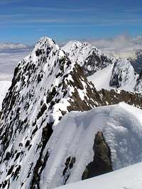 Crabioules & Maupas
 Boums du Port
 Hourgade
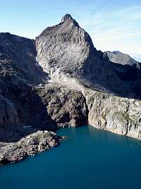
 Lac Bleu
 Daffodils near Pic d'Aubas
In short, the limits of this area can be defined quite simply: it corresponds to the French watershed of the Garonne, leaving the Ariège to the East. The Val d'Aran, despite owning the Garonne as well from Saint-Béat, is a part of the Spanish territory (the only administrative "illogicality", from the geographer's point of view). For this practical reason, it is merged with the Aigüestortes Area, to which the Aran mountains form the northern periphery.
View Nestes & Luchonnais in a larger map
- In the west, the Neste d'Aure makes the limit with the Bigorre, with the villages of Arreau and St.Lary Soulan on it.
- In the S.W. the border faces the valley of Gistaín, described in the Bielsa area along with the massifs of Bachimala and Posets.
- In the S.E the border faces the valley of Vénasque, behind the large massif of Gourgs-Blancs-Perdiguère-Maupas. These mountains have interesting routes from both sides.
- In the east, a small range of small mountains, crossed by the road pass Portalet, separates the Val d'Aran (province of Lleida, Catalonya). Further, on the opposite shore of the Garonne, a zone of low woody mountains makes a soft transition with the Ariège to the East.
- On the North, the towns of Lannemezan and Montrejeau, well served by the A64 motorway (never so close to the range than here), mark the end of the hilly zones and give place to the plain of the Garonne valley.
Getting There
 Crabioules ridge
 Crabioules ridge
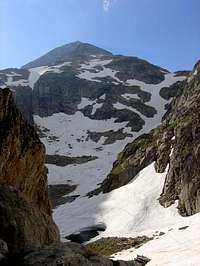 Perdiguère east face
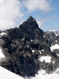 Crabioules
By public transports
French public transports are concerned as the area is on this side.
The Luchonnais area, due to its touristic popularity and ski resorts, is quite well served with public transports, in comparison with other French areas of the piedmont of the Pyrenees.
Bagnères-de-Luchon
The Aure valley used to be served by train as well, until Arreau, but this line is currently used only for industrial purposes. There were talks about reopening it for passengers, but no idea when.. in the meantime, both Saint-Lary and Loudenvielle are served by the regular buses, despite connections are not very frequent.
The Garonne valley is also served by bus until Saint Béat, but unfortunately there is no direct bus continuing into the Spanish Val d'Aran.
All timetables can be checked on the SNCF website : www.voyages-sncf.com.
There might be as well some independant ways of transportation (private shuttles) to the ski resorts of Superbagnères, Saint Lary, Val Louron, Nistos or Mourtis, but not on a regular basis. If you come from far and want to explore all transport opportunities, it can be worth phoning to them and ask.
 Spain by car
As mentionned earlier, there are not many convenient passages except aside this region: via the West in tunnel of Bielsa, or via the East, via the tunnel of Vielha, then either the Portalet pass, or Saint Béat.
Those planning ascents of the border peaks from the Spanish side might also consider the possibility of reaching the deep valley of Viados, via the Gistaín valley, or the Benasque valley until the Hospital de Benasque. Val d'Aran, also in Spain, and valley Artiga de Lin also allow visiting the Salvaguardia area.
 Getting there...
 Port de la Glère
 Mail Pintrat over Gorgutes
 Litérole lake
 Clarabide gorges
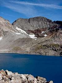 Crabioules
 Gourdon & Lac Glacé
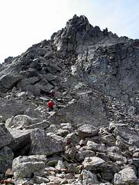 Gourdon summit
 Perdiguère from Sauveguarde
 France by car
Thanks to the A64 (E-80) Motorway that goes very close along the Pyrenees on its section between Saint Gaudens and Lannemezan, the access to the Luchon area is made very quickly, so quickly that it is possible to make a day hike from Toulouse without problem ! One can leave the A64 in Montréjeau or Lannemezan to reach either the Aure or the Garonne valley.
Both the Aure and Garonne valleys divide in two, like 2 Y, forming respectively the Louron valley from Arreau (E), and the Luchon valley from Saint-Béat (W), both unlinked to Spain and in cul-de-sac. Other secondary valleys develop in the Bas Luchonnais, like Bareilles from Arreau, Bourg-d'Oueil from Luchon, Barousse from Loures, or Nistos on the North.
The valleys of Bourg-d'Oueil and Barousse are linked by a tiny road open in summer only, Col de Pierrefitte. Ask in the tourist information to know if it is open at the moment you plan.
Other mountain passes allow going between the four main valleys, along the high range: Col d'Azet from Aure to Louron (Saint Lary to Loudenvielle), Col de Peyresourde from Louron to Luchon (Loudenvielle to Bagnères-de-Luchon), and Col du Portalet from Luchon to Aran (Bagnères-de-Luchon to Bossòst). Check also for their opening dates with the tourist information of Luchon or Saint Lary.
Circumventing the Azet or the Portalet pass via Arreau or Saint-Béat is usualler shorter both in time and petrol than driving them by car, a drive which is made slowly due to the number of turns. On the other hand, taking Peyresourde from Louron to Luchon is indisputably the best option.
If however you switch from the Aure to the Garonne valley via the piedmont, avoid taking the National road D817 running from Lannemezan to Montréjeau parallel to the motorway: this road is often crowded and with traffic jams. If you prefer sceneries, use rather the smaller D938, continued by the D26, via Rebouc, Héchettes, Mazouau, Saint Arroman, Bizous, Nestier, Aventignan, Sarp, Izaourt, and Barbazan. Each of these villages, on the very foothills of the range, own treasures of local architecture and driving this road full of bends is simply delicious !
View Larger Map
Nature and Regulations
 Isard (Pyrenean Chamois)
 Deer belling
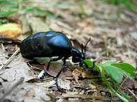 Oil beetle
This area is a "gap" between the Parc National des Pyrénées and the Parc Naturel des Pyrénées Ariégeoises, then not subject to any regulations.
However, one should avoid :
- Making fires
- Leaving rubbish
- Wildcamping near roads of habited zones (preferably in the subalpine level)
The area of Luchonnais is perhaps the most varied of the French side of the range when it comes about wildlife diversity.
The Isards (Pyrenean name of the chamois) are met in huge herds, especially around in the unvisited valleys of the Bachimala area, which sometimes host hundreds.
Some bears of the core population in the Ariège to the East regularly venture here as well.
Brown vultures, one of the largest bird of prey in Europe, is seen over almost every possible ascending stream, flying in large circles.
The hardwood forests of the Bas-Luchonnais are a dream land for the deer, whose belling (le "brâme du cerf") is draining crowds of nature lovers in the autumn.
Finally, let's mention a last surprising animal, whose appearance doesn't suggest at all it is endemic to the Pyrenees: the Desman. It is found in almost all streams of the french side, but particularly often in the Pays des Nestes (rivers of Aure and Louron valleys).
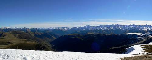
 Panorama to the Batoua
Rioumajou-Bachimala group
 Beautiful Sarrouyès
 Himalayan Aret
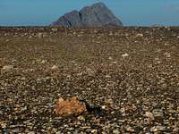 Rioumajou altiplano
 The mountains of the Rioumajou group
East from the limestone Monte Perdido group ending in the Munia, and opposite a group of large mountain passes, which form the end of the Aure valley, start a zone with several medium individualized peaks, not very often visited.
The westernmost ambassador is Pic de Garlitz (2798), whose schists announce the geologic transition, as well as the Bataillence, popular ski-touring goal. They are followed by the picturesque Vallée du Moudang.
The next ridge contains two popular summits, the Arriouère (Ibonet, 2867) and the Aret (2935), already teasing the 3000 limit. Seen from Saint Lary, this peaks produces a big impression.
Then, the wide and magnificent Rioumajou valley and its "hub" of trailheads give access to the first duet of three-thousanders, the famous Batoua (Culfreda, 3034) and Lustou (3023).
But not only: the Tuquet de Cauarère (Peña Blanca, 2688), the Thou (2743), the Estos (2803), or the Sarrouyès (2676) and Cap de Laubère (2213), more north.
Other goals such as the Suelza and the Fulsa, despite entierely in Spain, could be mentioned too, via the passes of Plan and Ourdissetou.
 Bachimala over Port de La Pez
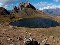 Consaterre lakes
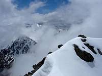 Snowy Lustou
 Smoking Batoua
 Vallée du Lys
Then, the large valley of Louron is reached. Apart from Port de la Pez that gives access to the upper Gistaín valley and the Viados area, there are not many large passages to Spain.
The second branch of the upper Louron valley is called Vallée de Clarabide, beginning with a long deep gorge, and in which is located the Refuge de la Soula (1710). Here, start the real "festival of peaks" of the Luchonnais, and the range of possible hiking goals is huge.
Via the long monotonous Aygues-Tortes west branch, one can reach the Schrader, a huge massive mountain named after the explorer, called by its original name in Spanish : Bachimala (3174). Just like its foresummit the Abeillé (3029). However both of these three-thousanders are better reached from the south (see the Bielsa area).
One detail that characterizes this whole area is the lack of lakes, or almost (small exceptions like those of Catchet, Hechempy, Trigonero, Consaterre, Sarrouyès, Aygues Tortes). This can be explained by the nature of the stone, not yet granite.
Gourgs Blancs group
 Stairways to heaven
 Pouchergues from Clarabide
 Sunrise on the Gourgs Blancs
 Gourgs Blancs group from the West
The eastern half of the Clarabide valley marks a geologic transition where the stone becomes a firm granite, which will remain all over the main ridge of the Luchonnais from now.
The first large group of mountains met near the Gourgs Blancs, the westernmost of the giants of the Luchonnais. Perhaps most famous due to its jagged shape, like a decreasing set of teeth, recognizable from everywhere. Its name comes from its numerous frozen tarns, "gourg" being a local name for them.
Other less remarkable three-thousanders belong to this chaos of alpine peaks, such as Clarabide (Clarabida, 3020), overlooking a splendid altitude lake, Gias (3011), Spijeoles (3065), Seil de la Bacque (Seil dera Baquo, 3110), Arlaud (3065), Belloc (3008), Portillon d’Oô (Pic Ollivier, 3058), or Gourdon (3034), often mentioned amongst the easiest 3000s of the range (along with Campbiel).
Some other summits fail to reach the 3000m limit, but are not less remarkable, like the northernmost Hourgade (2964), first-class viewpoint to this area, or the Tusse de Montarqué (2889), the easy belvédère near the Portillon hut, for those unkeen in scrambling.
 Lake Espingo
 Heading to Clarabide
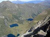 Oô, Espingo, Saussat
 Portillon lake & Crabioules
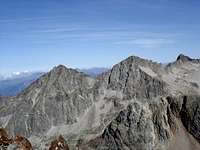 Quayrat & Lézat
Three famous glaciers are present in the area:
- Glacier du Seil de la Baque, one of the largest of the french side
- Glacier des Gourgs Blancs
- Glacier de Pouchergue
This group is commonly explored via four possible trailheads :
- The Caillouas and Pouchergues valleys, with their eponymous lakes, from the Refuge de la Soula, mentioned earlier, on the West. It connects the Astau valley via the pass Col des Gourgs Blancs, a challenging and scenerical traverse for those not keen in bagging any peak.
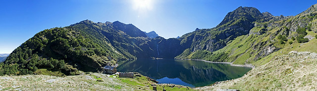
- The very touristic valley of the Espingo and Oô lakes, with Refuge d’Espingo (1950) and Refuge du Portillon (2571), starting at the Granges d’Astau. It is worth mentioning the Oô lake as a site of an exceptional beauty in the Pyrenees. Espingo, Saussat Portillon and Lac Glacé, upstream, can justify by themselves an entire hike dedicated to lakes.
- From Spain, many peaks of the ridge are reached from the Vénasque valley and the Refugio de Estós (1895).
- The northernmost zone, with the Hourgade, Nord Nère and Belle Sayette, is conveniently explored from the pass Couret d'Esquiery.
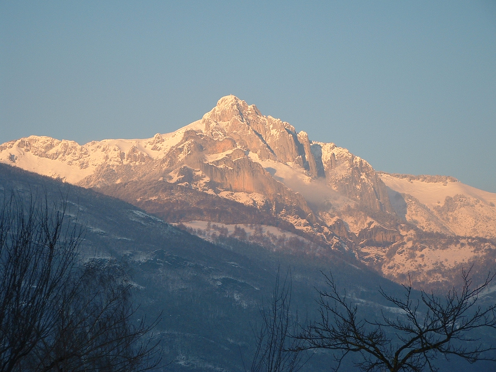
Perdiguère group
 Seil de la Bacque
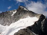 Maupas
 Perdiguère
 Crabioules south face
The Perdiguère (Perdiguero, 3222m), a huge massive mountain, ruthless maze of unstable granite boulders, is the tallest of all the Luchonnais group. It has many tentacles with several secondary peaks over 3000m as well. This is the largest and most alpine group of this are: if the Luchonnais was an orchestra, it would be the drums !
This mountainous system to the Gourgs Blancs on the west by the high saddle of Portillon d'Oô, inaccessible due to its huge vertical walls. To the East, it connects the Crabioules, via the passes of Litérole (two: the high and the low, 2983), an important passage that connects to the routes from Vénasque.
On this ridge are located several small three-thousanders such as Pointe Litérole (3132m), Pic Royo (3121m) and Tuc de Litérole (Literola, 3095m), with easy rock-climbs to their respective summits. The fore-summit of Perdigueret (2814), entirely in Spain on the east ridge, is also worth of mention.
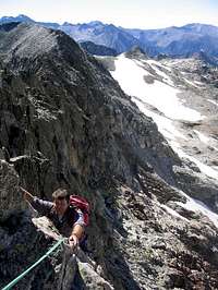
Continuing on the main ridge to the north, slightly excentred, stands a sub-range culminating at the Crabioules (3116).
An impressive ridge links it directly to the peak Lézat (3107), making it one of the most famous rock-climbs of the Pyrenees, over the well-known "Aiguilles de Lézat", which consists in four jagged pinnacles.
  |
 Litérole lake
 Perdiguère & blue Litérole
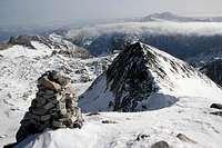 Perdiguère summit
 Sunset on the Perdiguère group from the Montségu
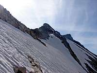
North from them stands the Grand Quayrat (3060) overlooking the Cirque d’Espingo. As it names suggests, it has a little brother on the north named Petit Quayrat (2847m), as well as few other peaks failing to reach 3000, but not less popular, like Hounts-Secs (2698), and still decreasing further north, until the Céciré (2403) a marvelous observatory, near the ski resort of Superbagnères (1800m), reached by a short walk.
Still more east on the main ridge, we reach the impressive Maupas (3109m) and the rocky pyramid of Boum (3006m). As its name suggests, Maupas (Mal-pas = mauvais pas, "bad step"), is a challenging goal. Boum designates another local name for a mountain tarn.
The range then decreases progressively under 3000m, via the peaks Mail Barrat (2986m), Mail Planet (2948m), Mail Pintrat or Pic de Port Vielh (2851m), Estauas (2754m) and Sacroux (2676m).
All of them overlook splendid alpine lakes, and make popular hiking destinations from the Lis Valley (Vallée du Lis), accessible from Luchon. The wide pass Port de la Glère (2367m) marks the separation with next group of Sauveguarde, below.
 Gias lakes
 Perdigueret
 Looking into the blue...
This group is the richest talking about glaciers. Five significant ones can be counted:
- Glacier du Portillon d'Oô
- Glacier des Crabioule
- Glacier du Maupas
- Glacier de Boum
- Glacier des Grauès
This mountainous unit is reached either via the Astau valley, with the refuges of Espingo and Portillon, as well as the Lis Valley, also featured by a mountain hut, Refuge de Maupas. Only few mountains like Crabioules and Pointe de Litérole can be reached from Spain, via the Literola and Remuñe Valleys, from Hospital de Benasque.
Sauveguarde group
 Port de la Glère
 Panorama of Port de Vénasque
The last imoportant mountainous group on the main ridge is significantly lower than the previous ones, however still a popular hiking area. It consists in the group of peaks overlooking the Pique valley (Vallée de la Pique). While the section oriented from west to east still separates the Vénasque valley, the section that runs to the north separates the Val d'Aran. This is the separation between the two spanish regions of Aragon and Catalunya (provinces of Huesca and Lleida), and their junction can be realized, on the spanish side, via the pass Puerto de la Picada (Port de la Picade) (2470).
Pic de la Sauveguarde (Salvaguardia, 2738) is the tallest peak. Pic de la Mine (2708), its eastern close neighbour shares the same popularity amongst hikers. Between them lies the pass Port de Vénasque, formerly a very used passage to Spain, nowadays renown for its panorama to the Maladeta.
 Salvaguardia from Spain
 La Mine & Sauvegarde from Sacroux
 Boums du Port in autumn
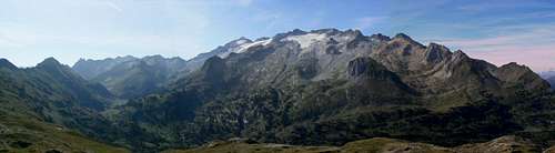 Panorama from Port de Vénasque to the Maladeta
 Montious and Lake of Bareilles
Other summits such as Pic de la Montagnette 2558), Pic de La Pique (2394m), Pic du port de la Picade (2553m), Soum de l’Escalette (2466m). No glacier is present in the area, but this is compensated by the number of lakes. All of the peaks allow visiting splendid lakes Vert, Bleu, Charles, Célinda, Port Viel, Montagnette, Boums du Port. Romantic names !
On the north section, Pic de Pouylané (2219), Campsaure (2141), Aubas (2071) make the continuity over the Val d'Aran. All these summits are reached via the Vallée de la Pique, whose trailhead is the Hospice de France (1385).
As we pass the Portalet road (possibly used as a trailhead too), the ridge rises a last time over 2000m, and other summits of interest are met : Montagnette (1992), Montmajou (2082), Bacanère (2193) and Pic de Burat (2154). Sacaube (1770) is the last sentinel over the Garonne valley, facing the Ariège. They can be reached from Luchon itself, without involving any motorized approach, for a day-hike.
This was the northern ridge, following the administrative border. Along the water divide, geographic border, two last mountaintops are worth to mention, before the pass Col de Toro (2236), lowest point that can be considered like the mountainous junction with the Maladeta and the SP Benasque : Tuca de Bargas (2627) and Tuc de Pomero (2697).
All the peaks previously mentioned are also reached from Spain: Those in the Vénasque part by the Hospital de Benasque or Refugio de la Renclusa, those on the Aran side from the villages on the main road, or the valley of Artiga de Lin, a beautiful trailhead.
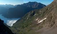
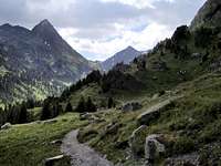
 Louron valley below
Bas Luchonnais & Comminges
 Main range in the distance, from the Mont Né
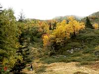
 Forest atmosphere
The overview of the Luchonnais cannot be ended without few words about the Bas Luchonnais.
Starting all over from the west, Tuc de Labatiadère, separating the Aure and Louron valley near Col d'Azet, makes a small Preamble.
On the opposite side of the Louron valley starts a huge area of dense forests and pastures, called the Comminges mountains, north from the Peyresourde pass (Val Louron ski resort), and fading out until Nistos. Their access is shared by three main valleys: Vallée de Bareilles from Arreau on the West, Vallée du Bourg d'Oueil from Luchon in the SE, Vallée de Barousse from Loures on the NE. All of them are famous for their very picturesque villages.
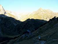
 On the way to heaven
 Sunset on the Bas Luchonnais from the Montségu
 Clearing
Its north neighbour, Mont Né (2147), almost as tall but as rounded as Montious was sharp, shares the popularity, partly because it is very shortly accessible via a road leading to Port de Pierrefitte (near Port de Balès). Pic du Lion (2102), is also worth mention.
The Cap Nestès (1772) with its cliffs, is another famous hiking goal, from Cap Nistos or Ardengost. Montagne d’Areng (2079), caracterised by rocky outcrops too, can be reached in its continuity, just like Mont Aspet (1849) if we head north.
Anténac (1990), is the most famous destination, separating Barousse and Bourg d'Oueil like a cape on the East, for the hikers seeking a day-walk from Luchon.
 Autumn walk
 Looking East to the wide immensities of the Bas Luchonnais, from Montious
 Evening over the Luchonnais
Finally, the Montségu (or Cap des Hittes, 2354m), just over the pass Couret d'Esquiery, is the last sentinel before merging into the Haut Luchonnais near the Hourgade.
A crowd of trailheads are possible to reach all these places. Almost every surrounding villages have some track elevating to the pastures. The laziest will use the road passes of Port de Balès (1755), Col de Peyresourde (1569), or Station de Nistos (1580).
As we pass Saint Béat, whose marble quarries produced the columns of Château de Versailles, on the opposite from the Garonne bed and just before the limit with the Ariège, rise a last group of mountains worth mention, called Comminges after the historical region. The Cagire, accessible from the Col de Mente and the Mourtis ski resort, culminates at 1912m, around few neighbours like Pic d'Escales (1816). But the emblematic peak of the area is certainly the Pic du Gar (1715), whose real top is Pic Saillant (1785). With huge limestone cliffs that can be admired from the main road, it is the pet dolomitic mountain of the place.
As a conclusion, let's mention that the Bas-Luchonnais is regarded as a very rewarding area for mountain biking. Its wide grassy slopes also make excellent take-off spots for paragliding.
In winter, when the avalanches risk levels make it too risky in the High Pyrenees, the Bas Luchonnais is also the terrain of predilection for Pyrenean mountaineers when it makes a fine terrain for snowshoeing, ski-touring, or even cross-country skiing (including in the domain of the Nistos cross-country skiing domain
 Refugio de la Renclusa
Sleeping
 Refugio de Estós
 Refuge du Maupas
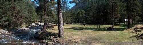 Frédançon (good bivy place too), in the Rioumajou valley
 Refuge du Portillon
Bivouacking, wild-camping
As mentioned in the red tape, there is no regulation due to any particular status of this zone, however avoid camping near inhabited areas. Do it preferably over the tree line in the subalpine level. Camping near mountain huts, using them only for eating and toilets purposes is allowed, despite it can be a surprising attitude in other countries.
The Rioumajou valley owns a bivouac area near the Hospice de Rioumajou, only for mountaineering purposes. Which means that you cannot camp permanently on it. Removing the tent in the morning is required, despite leaving it the time of the hike is usually tolerated. Do not park also near the tent, but on the car park for this purpose.
Unguarded huts and shelters
The Pyrenees have an incredible amount of places of this kind, which are inventoried in this fantastic site : www.pyrenees-refuges.com. This interactive map allows to locate them : http://www.geopyrenees.net (click "cabanes").
Official Campsites
One will find several convenient campsites in Saint Lary, Loudenvielle, Luchon or Saint-Béat.
 Refuge d'Espingo
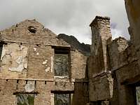 Ruins of the Pouchergues power plant. Yes, one can sleep in it !
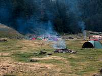 Rioumajou designated bivouac area
Guarded Mountain huts
- Refuge de la Soula
- Espingo
- Portillon
- Hospice de France
- Refuge de Maupas
- Refugio de Estós
- Hospital de Benasque
- Refugio de la Renclusa
Accomodations in the valleys
All the previously mentionned valleys have a crowd of possible accomodations. The most simple is to type places names in Google, or to check the touristic portals of these resorts and valleys:
- www.vallee-aure.com
- www.vallee-du-louron.com
- www.paysdesnestes.fr
- www.bourgdoueil.com
- www.lesvalleesdesaintbeat.fr
- www.luchon.com
- www.saintlary.com
One accommodation is worth mention for large groups of people: La Filature (former spinning mill), in Ancizan, with further information here and here (French). Prices can go as low as 10€ for groups over 10 people. A separate apartment is available too but rates may vary depending on the charges being shared with others or not.
Maps (paper and numeric)
Numeric mapsDue to the copyright policy of the IGN, it is not possible to scan and include map samples without permission. The only way to consult them online is via the database Géoportail, easily browsable via the site ClicGPX (we need to unzoom, move to the central Pyrenees and rezoom again)
Paper maps
Two types of maps are usually found in France for the Pyrenees :
- The TOP 25 series of IGN, high quality maps at the 1/25000 scale, mandatory for hiking the four high regions mentioned above (from Rioumajou to Sauveguarde). Several maps cover the area described in this page: 1748ET (Aure), 1848OT (Luchon), 1847OT (Bas Luchonnais), 1947OT (Comminges). See the France index for a more accurate look.
- The Rando Editions series, at the 1/50000 scale. This kind of map is usually enough if we stick to the trails, as well as for the soft relief of the Bas Luchonnais and the Comminges. One whole map covers the whole area described in this page: the N° 5 Luchon.


visentin - Nov 19, 2010 3:18 am - Hasn't voted
zonesHello Rafa, As we said I'm thinking about starting to improve a bit the french areas pages. Comparing the disproportioned amount of objects located in the Bigorre and the Luchon area, something came into my mind. The Bigorre is a region extremely wide, which gathers most famous peaks of the Hautes Pyrénées, correspondly roughly to the department "65". On the opposite the Luchon area is very small in superficy compared to it (the french department 31, Haute Garonne). The goal would be to "unload" a bit the Bigorre by transfering some of the peaks to Luchon (we already can't see the whole peak list in the left pannel, there is "5 more" in the bottom !). This is partly due to the fact that the whole Vignemale group was wrongly attached to the Béarn and I corrected it few days ago. Since the peaks located in the Aure/Louron area (Batoua, Lustou, etc) are more connected to the Luchon group than The Monte Perdido group, I thought about renaming "Luchon" into "Aure/Luchonnais", and Bigorre into "Adour-Bigorre". It also makes senses in the way that the separation between these 2 regions is the water-divide between the Adour river and the Garonne river, as it is already for the borders of the "Ariège" with the basin of the eponymous river, and is also for "Bearn" with the water-area of the Gave d'Aspe and Gave d'Ossau. In this way, water divides would help SP contributors to sort out easily the appartenance of each peak to a group on the north side, and having areas with proportional amount of peaks. What do you think ?
Rafa Bartolome - Nov 19, 2010 10:24 am - Hasn't voted
Re: zonesI will think about it. In my opinion the most important thing is the trailhead and not the correct situation of the peak. If a trailhead of a peak it's in an area I think that the peak must be appear in the area, even the peak will be in two areas. It's not really very important if an area is bigger or smaller than other, the most important thing is the roads and the trailheads to visit a peak. The people need to know the peaks to climb from Bujaruelo even if you go out of the area. Vignemale is the most difficult to add correctly, but the trailhead must decide it. If a mountaineer can climb from Bigorre, Tena (valley of Ara to coulouir of Cerbillona or Moskowa) and Ordesa (Bujaruelo for Grand Tapou)... maybe it's possible to attach to different areas: in Bigorre: Grand Vigenale, Clot de la Hount, P.Carré, Chausenque and Petit Vignemale. In Tena: Cerbillona, Central and Montferrat. In Ordesa: Grand Tapou. What do you think about it? It's normal the confluence of a lot of peaks in the center of Pyrenees because the range has the most higher peaks in that zona. It's the reality, Benasque, Bigorre or Ordesa/Gavarnie have a lot of peaks and Luchon has less peaks.
visentin - Nov 19, 2010 10:36 am - Hasn't voted
Re: zonesSure, if we take water divides to define zones, then peaks tend to be located on borders of 2 zones: then the most logic is to attach the peak to the two zones as often as the peak is accessed from both sides. The same way exactly when a peak is on the international border, when we attach it both to spain and france. As for Bigorre/Luchon, I'll try to implement the repartition I proposed just to have a look; if it is too confusing we can always come back to the initial zones as they are now.
visentin - Nov 22, 2010 5:32 am - Hasn't voted
Re: zonesIndeed, I carried few researches about the origins of the "Bigorre", and found out the Nestes valleys (Aure and Louron) were not always a part of the Bigorre Kingdom (when they were, only an unsignificant part). In fact the confusion might come from the fact the Aure & Louron belong to the "65" departement (Haute Pyrénées) and not "31" (Haute Garonne, Luchon). Then, if we respect this definition, the small group of Lustou, Batoua, pic d'Estos, Montious, goes to Luchon. On the other hand, Néouvielle and neighbours remain in the Bigorre. To make it more clear, I renamed "Luchon" as "Luchonnais & Nestes", the names we usually give to these regions in French (Luchon being only one town). The number of peaks become also less disproportioned. Have a look and tell me how you find it. Cheers ! Eric
Rafa Bartolome - Nov 22, 2010 10:39 am - Hasn't voted
Re: zonesthank you very much for your work. I like it.