|
|
Mountain/Rock |
|---|---|
|
|
46.36914°N / 13.78218°E |
|
|
6837 ft / 2084 m |
|
|
Overview
Geographical structure: Eastern Alps > Julian Alps > Triglav group.Zadnjiski Ozebnik is a not very important mountain on the margin of Triglav group and it is located above the second valley of the big Trenta valley called Zadnjica. The north face falls around 1000 meters high down steeply in to the Zadnjica valley. Zadnjiski Ozebnik is located in the nearness of the giant Kanjavec, 2569m. It is in the NW ridge that comes from Kanjavec over the Vrsac, 2194m and then that ridge falls down on the pass Cez dol, 1632m and then rises up to the last mountain Zadnjiski Ozebnik before the long Trenta valley.
Zadnjiski Ozebnik is very variegated mountain. On the south side it is not very steep and very nice for tour skiing but on the north side has very steep and airy north face where are some nice climbing routes. The main summit is high 2084 meters but it has some lateral summits such as Veliki Konj, 2034m (on the SW ridge), Velika glava, 1882m (on the SW ridge) and Veliki Vrsovec, 1856m (on the NW ridge). But for the hikers and climbers is popular only the main summit because other summits are far away and if you want to reach it you must be very patient when you will punch through the dwarf pine and forests.
 ..
..
The photos of Zadnjiski Ozebnik on other pages.
The normal approach on the Zadnjiski Ozebnik goes from the beautiful valley Zadnjica and then through the smaller valley Zadnjiski dol on the pass Cez dol. Here you leave the marked route and you continue your way in the south direction on the south slopes of Zadnjiski Ozebnik. Here is no marked route but you will see some hunting routes or the traces of forerunners. It is not very hard to reach the summit over nice grassy slopes. You can reach the pass Cez dol also from the west side over the marked route through the valley Trebiski dol and then just continue like on the first possibility.
View from Zadnjiski Ozebik
The view from the Zadnjiski Ozebik is very good because Zadnjiski ozebik is located between the Triglav group, Mangart and Jalovec group and Razor and Prisojnik group. So you can observe all the giants of Julian Alps. The special view from Zadnjiski Ozebnik is on the Triglav, Pihavec, Kanjavec and on the beautiful north face of Vrsac.
View on the famous north face of Vrsac from the slopes of Zadnjiski Ozebnik.
Getting There

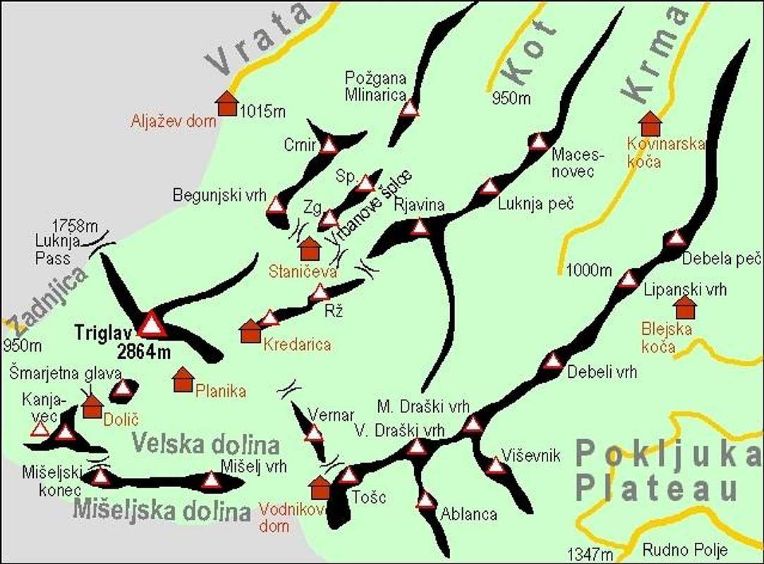
The map of Triglav group. Zadnjiski Ozebik is the summit on the left of Kanjavec and Vrsac.
For climbing on Zadnjiski Ozebnik is the best starting point Zadnjica valley.
Zadnjica is quite short (3.5km) subsidiary to famous Trenta valley. It begins at Trenta village and opens towards east. It gradually rises till its end at Planja (1000m). Bottom is mostly forested and there are few meadows. Around the valley is some of the most dramatic scenery in Julian Alps. The cliffs of Pihavec (2414m), Triglav (2864m), Kanjavec (2568m), Vrsac (2194m) and Zadnjiski Ozebnik (2084m), which fall into dark depths of Zadnjica have no match in Julian Alps. They create amazing wall around the valley, which culminates with highest face of Julian Alps, that of Kanjavec, which is 1500m high! In the valley is dark and subdued atmosphere because walls around are letting very little sunshine in. End of valley is reached by road, which is closed to traffic 2km above the Trenta village.
For more information check the main page of Julian Alps and the subgroup page of Triglav group.
Maps:
Routes Overview
Red Tape
No limitations but Zadnjiski Ozebnik is located in the Triglavski Narodni park so you must be kind to the nature and other beauties.When To Climb
For Zadnjiski Ozebik is the best time for climbing from Spring to Autumn and for the north face the long Summer days because the climbing route in north face of Zadnjiski Ozebik are very long and they take you a lot of time.For tour skiing is the best time when you have a lot of snow but when there is no risk for avalanches.
Camping
Camping inside the Triglav National Park is forbidden. Beside the mountain huts there are plenty of hotels and private apartments in the towns and villages, which surround the area. Here are few links where you can find info on accommodations closer and further away:Kranjska Gora
Bovec
Mojstrana
Bled
Mountain Conditions
Mountain conditions in Julian Alps are well known, thanks to Kredarica (2515m) hut and meteo station, which is below the Triglav.You can observe current conditions and forecast for Kredarica on the Wunderground meteo site. Here is direct link to Wunderground - Kredarica page.
Some weather informatin can also be found here.


Vid Pogachnik - Jan 8, 2007 5:45 pm - Voted 10/10
Four routesYou can mention in the text the following 4 climbing routes: 1. Centralna smer (Central Route). III-IV/V, 900m. Joze Skodic – Tone Valic, Aug. 8th, 1953. 2. Mariborska smer (Maribor Route). V, IV/II, III, 1000m. Ivan Gverlin - Davorin Podrebsek, Aug. 28.-29., 1976. 3. Vrnitev (Return). Ice details 85°-90°, rock details V+, very crumbly; average ravine inclination 45°-50°, 1000 m. Pavel Podgornik, Peter Podgornik, Dusan Rijavec, Milan Velikonja, Feb. 13.-14., 1982. 4. Leva smer (Left Route). V+/III-IV, 600 m. Zlatko Koren - Peter Podgornik, Sep. 10th, 2006.