
|
|
Mountain/Rock |
|---|---|
|
|
38.84610°N / 107.223°W |
|
|
12432 ft / 3789 m |
|
|
The West Elks Overview
The West Elk Wilderness comprises a remote and mountainous area west of Gunnison Colorado. The West Elks encompasses 176,000 acres of Gunnison National Forest, making it the fifth largest wilderness in Colorado. This region resides south of Kebler Pass, which runs east from Paonia State Recreation to the tiny ski resort of Crested Butte, and south to the Curecanti National Recreation Area. The areas volcanic ridges and long valleys offer extensive hiking and climbing. Over 200 miles of constructed trails are available for both foot and horse travel through this sometimes-rugged terrain. Elevations within the Wilderness range from 7,000 to over 13,000 feet. Because the area lacks fourteeners, centennial thirteeners and numerous alpine lakes you will get the benefit of hiking alone and away from the typical recreational visitor.
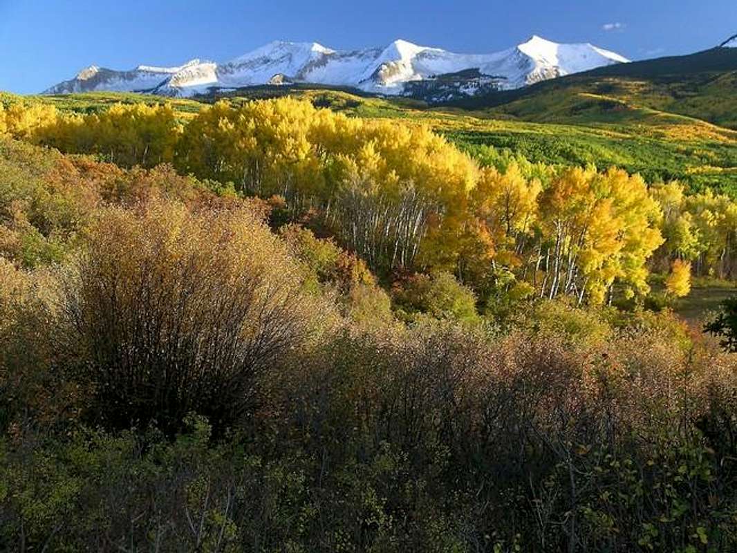
In late September into early October, nothing beats the West Elks for fall color. Photographers, hikers and climbers are rewarded with a dazzling display of golden fall foliage. The nearby Curecanti Recreation Area and Uncompahgre Wilderness also share the same climate, a dry climate that varies greatly from day to night and provides minimal precipitation. During spring or summer, freezing morning temperatures quickly make room for afternoon warmer temps; it’s not uncommon to feel a 20-degree swing from the shadows to the sun. This cool and dry climate is perfect for aspen groves, russet Gamble’s oak, maroon-colored serviceberry and mountain mahogany. In addition, the climate works well for wildlife including elk, mule deer, black bear, bobcat, mountain lion, and coyote.
In addition to the great fall foliage, the West Elks are outlined with charming small towns like Crested Butte, Crawford, Hotchkiss, Paonia and Somerset. All of these tiny towns offer an extensive network of dirt roads that escort you into the heart of the Wilderness. These roads have a reputation for being rough, muddy and rutted-out, especially after any recent precipitation. Also, be aware of roaming cattle.
East Beckwith Overview
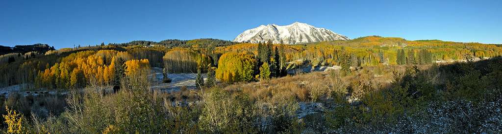
When it comes to experiencing the brisk cool temperatures of fall, golden aspen colors and clear blue skies, nothing beats the scenic West Elk Loop drive on Colorado Rd-12. This road starts at Paonia Recreational Area and ascends to Kebler Pass and on to Ohio Pass before descending to the town of Crested Butte.
Along this improved dirt road, visitors are graced with a perfect view of miles upon miles of flowing aspens. But the best part of this drive very well could be the five, glacially carved cirques that form East Beckwith Mountain. At 12,432-ft. East Beckwith along with West Beckwith form the centerpiece of this scenic vista viewed from the Kebler Pass Road. East Beckwith is more like a long elegant ridge, composed of igneous rock, the same whitish-gray rock responsible for the thin shattered ridges that swoop and rise gracefully on Snowmass Mountain and Capitol Peak. East and West Beckwith are considered part of the Anthracite Range, a sub-range within the West Elk Wilderness. The summit of East Beckwith sees about 15-20 visitors a year, most from the nearby town of Crested Butte.
As I alluded to earlier, East Beckwith is composed of five identical and symmetrically beautiful cirques. This mountain sweeps down from one highpoint to another via a skinny mostly class 2+ ridge. Attaining the easterly summit of East Beckwith is an easy and short class 2+ hike from Lost Lake Slough. But if you want to explore the long ridge running west, I would recommend a loop hike/scramble. Considering the width of this ridge, I was surprised that the difficulty never acceded class 3. The five or six northern ridges that extend from the main, east/west ridge are considerably more difficult to negotiate. So it is important to understand the further you hike west and away from the East Beckwith’s summit the more difficult it may be to descend back down into the valley, because you must select one of these north facing ridges to descend.
 |  |  |  |  |
Kebler Pass Rd/Lost Lake Slough
From Hwy 133, turn left on Co 12 and follow the road as it ascends towards Kebler Pass. This road is passable for passenger cars.This road is also closed during the winter season, from mid November to early May. Call the Paonia Ranger District (970-527-4131) for up to date conditions. At about 15 miles, look sharp on the right for a signed turn-off for Lost Lake Slough Campground. Follow this road another 2 miles to Lost Lake Slough and park; this is the trailhead. There is ample parking here.
Red Tape/Conditions
There are no fees to enter or hike this wilderness.For more infromation contact: