
-
 70849 Hits
-
 92.38% Score
-
 39 Votes
|
|
Mountain/Rock |
|---|---|
|
|
36.09360°N / 115.484°W |
|
|
Hiking, Trad Climbing, Scrambling |
|
|
Spring, Summer, Fall, Winter |
|
|
7070 ft / 2155 m |
|
|
Overview
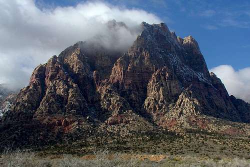
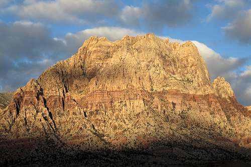
Mt. Wilson in the Clouds
As is to be expected from a world-class rock climbing area such as Red Rock Canyon, there are numerous technical routes on the peak. Approaches tend to be long (by rock climbing standards).
![Mount Wilson in Early Morning]() Mount Wilson in Early Morning
Mount Wilson in Early Morning
![Mt.Wilson]()
![Summit Block of Mount Wilson]() Summit Block of Mount Wilson
Summit Block of Mount Wilson
![Back Route to Wilson]() Back Route to Wilson-- click for extensive information.
Back Route to Wilson-- click for extensive information.
![The Wilson Massif, Dawn]() The Wilson Massif, Dawn
The Wilson Massif, Dawn
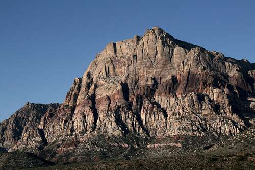
![Mt. Wilson]() Mt. Wilson
Mt. Wilson
The summit block itself is an easy scramble but offers a dizzying and unforgettable vantage point, for the eastern side presents a sheer drop of nearly 3000 vertical feet to the desert floor below. At the edge of the summit block, you are literally one step from being chop meat!
 Mount Wilson in Early Morning
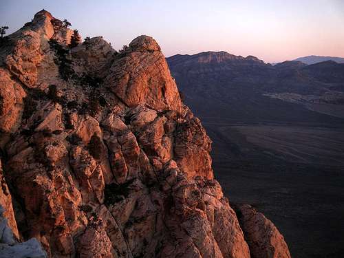
 Summit Block of Mount Wilson
Scrambling Routes
- First Creek Canyon-- Class 3. Considered the standard route, this is also the route that is said to be brushy unless followed correctly. RT distance is 10-12 miles.
- Hidden Bowl-- Class 4. It is an offshoot of the standard route that is more direct and avoids the brushy sections but is more challenging and more exposed as well.
- Oak Creek Canyon-- Class 4. The Class 4 sections involve bypassing waterfalls (often dryfalls) in the canyon. Above the canyon, the route is mostly a slog. RT distance is 10-12 miles.
- Cleaver Crack-- Class 4. It's an offshoot from Oak Creek Canyon, more direct but more challenging. RT distance is about 7.5 miles.
- Below is a map of a route from the west starting from Lovell Canyon Road. The submitter notes that the route is entirely off-trail and is perhaps the shortest route to the summit.
 Back Route to Wilson-- click for extensive information.
Subpeaks
Mount Wilson is blessed with at least five distinct subpeaks:
It is possible to climb White Rock Pinnacle, Dead Horse Point, South Wilson, and the main summit all in one outing. The others, though, are approached by different routes and would likely be sole objectives for most climbers.
 The Wilson Massif, Dawn
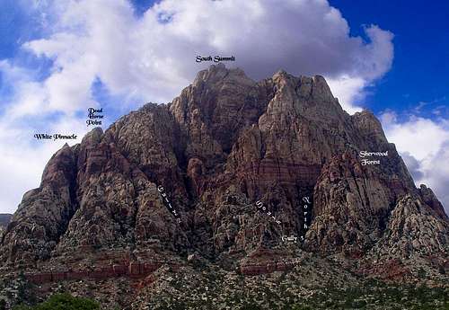 Mt. Wilson
Technical Routes
The following pages have information on several technical rock routes on Mount Wilson:
This route is not attached to either of the two above pages:
Getting There
Where you park depends on the route you want to use.
Take Charleston Boulevard (SR 159) west through Summerlin. After the development abruptly ends and the desert begins, drive a few miles to the well-marked entrance to the Scenic Drive. If you are using one of the routes via Oak Creek Canyon, you can turn off here and drive the one-way road for about 12 of its 13 miles to the trailhead for Oak Creek Canyon. This involves paying a fee at the entrance station; curves, hills, cyclists, and slow drivers will be factors as well.
The exit from the Scenic Drive is about three miles farther along 159. You can avoid the fee and the one-way loop drive by parking at the unmarked but easily seen trailhead for North Oak Creek Trail located along SR 159 a short distance west of the loop drive's exit. This, of course, adds some hiking distance each way-- 0.9 mi.
Hiking in from the signed Oak Creek Canyon TH off 159, which reaches the canyon via South Oak Creek Trail and the Chinle Trail, adds 1.5 mi each way-- definitely not recommended unless the other TH off 159 is closed for some reason.
If you are using one of the routes from First Creek Canyon, continue on just about a mile along 159 and find the roadside trailhead for that canyon. This, too, involves no fees.
When To Climb
Spring and fall are the best. Winter is not bad, but temperatures can be cold and the canyons can be icy. Summer ascents are not advisable because even with a predawn start, you are likely to be caught in the scorching heat during the return. The canyons can offer shade and running water, but the exposed sandstone is like an oven.
Red Tape
Scenic Drive--
There is a daily entrance fee of $7 per vehicle (2013). Annual and interagency passes are available (the Interagency Pass, AKA the America the Beautiful Pass, grants access to all federal fee areas for a year).
Hours the Scenic Drive is open:
13-Mile Scenic Drive
Note: these hours are subject to change. To be safe and sure, contact the park before visiting.
Hours the Scenic Drive is open:
13-Mile Scenic Drive
| November through February | 6 a.m. to 5 p.m. |
| March | 6 a.m. to 7 p.m. |
| April through September | 6 a.m. to 8 p.m. |
| October | 6 a.m. to 7 p.m. |
Note: these hours are subject to change. To be safe and sure, contact the park before visiting.
The BLM (the agency that manages this area) allows dogs in the backcountry. Please keep them leashed and pick up their feces.
Camping
There are no campgrounds off the Scenic Drive in RRCNCA. There is a campground outside it, though; see here for more details. Bivouacs and backcountry camping are permitted, but with permits and restrictions. Use the link at the end of this page to find out more.