
|
|
Mountain/Rock |
|---|---|
|
|
49.28848°S / 73.03825°W |
|
|
El Chalten |
|
|
Mountaineering, Trad Climbing |
|
|
Spring, Summer, Fall, Winter |
|
|
8392 ft / 2558 m |
|
|
Overview
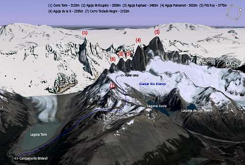
 Fitz Roy range
On the west shore of the Glaciar Rio Blanco and South of Aguja Poincenot (3002m), there are three granit peaks completing the FitzRoy range : Aguja Raphael (2482m), Aguja St-Exupery (2558m) and Aguja de la S (2335m - also known as Aguja Innominata). The main one (Aguja St-Exupery) takes its name from the French aviator called Antoine de St-Exupery (1900-1944), who was with Jean Mermoz and Henri Guillaumet, in charge of delivering mail all way down to Patagonia by plane. This was between 1929 and 1932 with the French airline company Aeropostale. The two summits north of Fitz Roy are actually called Aguja Mermoz and Aguja Guillaumet, dedicated to their memory too. Note that Antoine de St-Exupery was also famous as a writer, and his book "Le Petit Prince" (name given to a route on the West face) is still a best-seller in France.
These three needles are smaller climbs than its neighors Aguja Poincenot and Cerro Fitz Roy but they still offer difficulty, rock quality and an incredible atmosphere in the heart of Patagonia.
NB : Aguja means Spire
Getting There
 Laguna Capri
 El Chalten
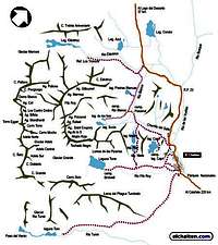
ACCESS
There are two ways to access El Chalten :
 The most common is by bus from El Calafate. There are 1 or 2 buses per day, taking 4 hours.
Two companies run this service : CalTur and Chalten Travel.
Second solution : you can come from Villa O'Higgins in Chile (southern end of the Carretera Austral) by boat (once to twice a week) across Lago O'Higgins. Then hike for 25 kms and take a second boat on Lago del Desierto. From there, there is an evening bus to El Chalten. All details on this incredible crossing : Cruce VOH a El Chalten.LODGING
As far as accomodation is concerned, there are several youth hostels and camp sites in town. One I can recommend that offers both beds and camp grounds is El Refugio, located on the main street (6$ per night and per bed / 2$ per night and per person in tent).
Kitchen facility and hot shower included in the bed price.
BASE CAMP
To reach the base camp of Aguja St-Exupery, you need to take the trail going to Campamento Bridwell (alt. 600m - also known as Campamento de Agostini). This is the actual base camp for Cerro Torre.
A higher camp is then set up on the Glaciar Rio Blanco at about 2000m. From there the ascent starts. To reach this part of Glaciar Rio Blanco from Campamento Bridwell, you need to go around the east shore of Laguna Torre, then up in direction of Cerro Techado Negro. You will then go around Cerro Techado Negro on its East face. 4 smalls passes later you will start walking north bound along Aguja de la S, up to the bottom of the Southeast side of Aguja St Exupery.
Red Tape and Weather Conditions
 Agujas de la S & St-Exupery Photo by poice2004
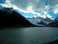 Laguna Torre Aguja Raphael, Aguja St-Exupery and Aguja de la S are part of the Parque Nacional Los Glaciares. A permit is required to ascend these peak. You can obtain it at the main office in El Calafate.
As any protected area, it is forbidden to camp outside campsite, or lit fires. Take all trash away with you.
Be aware that in Patagonia the weather can change brutally. From warm sun to snow storm in a few hours of hours, any time of the year. Take warm and waterproof clothes with you, and be ready for tough conditions. The best time to climb would be bewteen December to February, but there can be stronger wind during these months.Climbing Routes
 Aguja de la S, Aguja St-Exupery & Aguja Raphael
![]() AGUJA ST-EXUPERY (2558m)
AGUJA ST-EXUPERY (2558m)
EAST FACE
o Normal route / East Pillar (800m - TD+) by S. Metzeltin, G. Buscaini, L. Condot, W. Romano & S. Sinigoi (Ita) in 1968
o South Pillar (800m ED) by H. Bärnthaler & E. Lidi (Austria) in 1987
o Le Petit Prince (700m ED) by J. Arpin, P. Batoux, G. Bouquet des Chaux, E. Pellissier & B. Robert (Fra) in 1995
WEST FACE
o Clair de Lune (750m ED-) by M. Giordani & S. Valentini (Italy) in 1987
o Northwest face (700 5.10b) by Sue Harrington & A. Kearney (USA) in 1988
![]() AGUJA RAPHAEL (2482m)
AGUJA RAPHAEL (2482m)
EAST FACE
o Normal route / South Ridge (450m TD+) by M. Boysen, P. Braithwaite, L. Dickinson, D. Reid & R. Silvester (UK / USA) in 1974
o North Pillar (450m ED-) by D. Anker & M. Piola (Swi) in 1989
WEST FACE
o Corail (600m ED+) by F. Leoni & E. Salvaterra (Italie) in 1994
![]() AGUJA DE LA S (2335m)
AGUJA DE LA S (2335m)
EAST FACE
o Normal route (400m D-) by Bernard Amy and his French Expedition (France) in 1968
o Bärnthaler/Lidl route (450m TD-) by H. Bärnthaler et E. Lidl (Austria) in 1987
o Qui se souvient des Hommes ? (450m ED-) by Lionel Daudet solo (France) in 1994
o La femme de ma vie (450m ED+) by Lionel Daudet solo (France) in 1995
WEST FACE
o Jeu de glace (1300m TD+) by Gian Carlo Grassi, Roberto Pe & Mauro Rossi (Italy)
![]() MOJON ROJO (2163m)
MOJON ROJO (2163m)
South of Aguja de la S there is a smaller summit called Mojon Rojo (2163m). Two possible routes :
o East ridge (n/k) by Sergio Bassini, C. Fava & A. Vincitorio (Italy)
o West face (650m IV+) by Jim Bridwell (USA) & R. Staszewski (Australia)
Useful information
 Photo by Martin Tinak
 Photo by Enriq Book :
One guidebook with a little information about this peak is :
The Andes : A Guide For Climbers by John Biggar - Jul. 2005
ISBN : 0953608727
Map of the area :Monte Fitz Roy & Cerro Torre
Scale > 1:50.000
ISBN : 1879568292
Weather forecast :On Infoclima > El Chalten
Internet :Official website for El Chalten : Capital Argentina del Trekking
Official website for the National Park : Parque Nacional Los Glaciares
Excellent general information on Aguja Raphael, Aguja St-Exupery and Aguja de la S (in French) : Expé.com
Table of Contents
 AGUJA ST-EXUPERY (2558m)