
-
 6673 Hits
-
 90.48% Score
-
 32 Votes
|
|
Mountain/Rock |
|---|---|
|
|
45.93010°N / 7.44285°E |
|
|
Mountaineering, Skiing |
|
|
11660 ft / 3554 m |
|
|
Overview
What's new:
- Jul 13th, 2017 Inherited the page from Andrea.it.
- Sep 17th, 2017
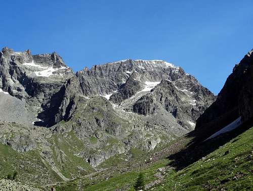
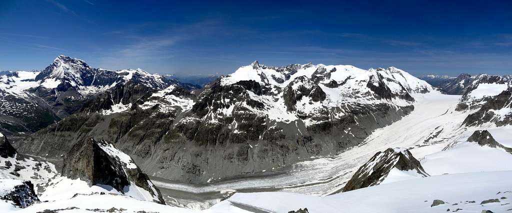
Forgotten mountain belonging to the Italian-Swiss border ridge between the glacier Otemma and the Valpelline (Aosta Valley) with elongated and almost rounded shape. It is enclosed between the "Col d'Otemma" (3.209m) on the North and the "Col de l'Aouille Tseuque" (3.259m) on the Southwest. At this summit have been attributed in the past several names as: "Becca Scorna", "Ouille Secca", "La Sciassa" and finally at the end with frenchization of the place name, "Aouille Tseuque". In the local dialectof the Aosta Valley it means "goat without horns". It has 3 Summits that overhang many spacious terraces.The top of the Northeast Summit where the snowy Northern Ridge joins the border ridge is the highest top. The Central Peak (3.540m) is around 130 meters far from the Northern and it hosts a trigonometric signal; the Southern (3.524 m) is located at 220 meters about away. Below the South Side there is a small glacier very close to extinction, named "Ghiacciaio di Grand Epicoun". It's rarely climbed in summer from both sides perhaps due to the long and difficult access, especially from the steep rocky slopes with cliffs of the Italian side. However, it is usually climbed in the spring time along the snowy slopes, but on the Swiss side. From south valley (Valpelline) can't be distinguished unless you get the highest slopes of the chain that closes Valpelline at south. From its summit you can admire one of the finest panoramas of Alpi Pennine staring at the Mont Velan, the Grand Combin, and the Dent d'Herens, and the big Glaciers of Otemma.
Montagna pressocché dimenticata appartenente alla cresta del confine italiana-svizzera tra il Ghiacciaio Otemma e la Valpelline (Valle d'Aosta) con forma allungata e quasi arrotondata. È racchiuso tra il "Col d'Otemma" (3.209 m) a Settentrione e il "Col de l'Aouille Tseuque" (3.259 m) a Sudovest. A questa Cima sono stati attribuiti in passato diversi nomi come: "Becca Scorna", "Ouille Secca", "La Sciassa" e alla fin fine e francesizzato "Aouille Tseuque". Nel dialetto locale della valle d'Aosta significa "capra senza corna". possiede 3 Vette che sovrastano numerose terrazze spaziose. La parte superiore del vertice Nordest, dove il pendio nevoso a Nord si unisce al crinale del bordo, risulta quale la Cima più elevata. Il Vertice Centrale (3.540 m) è situato a circa 130 metri circa lontano dal Nord e ospita un segnale trigonometrico; il Meridionale (3.524 m) risulta collocato a 220 metri circa di distanza. Sotto la Faccia Sud esiste un piccolo ghiacciaio molto vicino all'estinzione, chiamato "Ghiacciaio di Grand Epicoun". Raramente è salito in estate da entrambi i lati, forse a causa del lungo e difficile accesso, soprattutto dalle ripide balze e scogliere rocciose del versante italiano adducenti al Colle di Otemma (3.211 m). Tuttavia, di solito, è salito in primavera lungo i pendii innevati, ma dal lato svizzero. Dalla lato Meridionale della Valpelline non si può distinguere se non si superano elevandosi di quota i pendii più alti della catena, che rinchiude la Valpelline a Sud. Dalla sua vetta si può ammirare uno dei più bei panorami dell'Alpi Pennine, osservando il Mont Velan, il Grand Combin e il Dent d'Hérens, nonché grandi Ghiacciai d'Otemma.
First Ascents
- First ascent (SW Ridge): A. Baltzer, C. Schroeder, S. Bessard, (Jul 31th, 1867).
- NE Flank and the North Ridge (Swiss Normal Route): A. Tschumi and two unknown partners - Most logic route from Italy and Switzerland (PD) (BSA with ski), (Jul 25th, 1886).
- South Side and the SE Ridge: J. Henry, J. B. Gontier - Rarely climbed, (Aug 17th, 1906).
- Southern Face (Directly from the SW Summit): Osvaldo Cardellina, Eusèbe Imperial and Elviro Savioz, (Sep 09th, 1986), more direct but pretty dangerous route (PD/PD+/II°/II°+) in descent from Chamen Village, after the ascent through the Col d'Otemma and the subsequent North-northeast border Crest.
- NE Flank and SW Ridge: A. Baltzer, C. Schroeder and S. Bessard, - 31/07/1867, (Jul 31th, 1867).
- WNW Flank: M. Kurz and C. Favre - This is the normal route from the Cabane de Chanrion, (Oct 16th, 1922).
- North Ridge: E. Frohlich and F. Keller - Interesting rock climb route, (Jul 22th, 1923).
- ESE Wall: Gino & Silvia Buscaini - Fine route with passages of III°/IV° 350m, (Jul 07th, 1970).
Getting There
From Switzerland (North): Along the route from Martigny reach Sembrancher where a route follows the Val de Bagnes till Mauvoisin (1.840m) near a big dike. By a white narrow route (some danger, not always open) you can reach the Cabane de Chanrion (2.462m) near the end of Otemma glacier. Otherwise from Arolla (Val d'Herens) take the direction to the Cabane de Vignettes and then across the glacier d'Otemma to the foot of the mountain. From Italy (South): Along the route Aosta-Gran San Bernardo till Valpelline village, then along the new Valpelline route till the hamlet of "Grand Chamen" (1.710m). A paved road takes in the valley of Grand Chamen. The entrance is usually forbidden. But it's possible to try to get up to the valley with a 4X4.
Italian Normal Via with difficulties
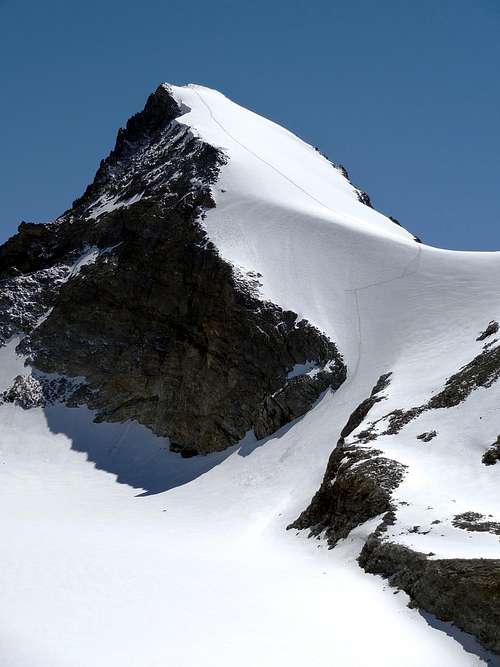
Wild route! Very long (1.844m drop) and very rarely repeated in the summer, it has no signs or cairns. The phone signal disappears a few hundred meters above the parking lot, not to ever appear along the way. Most of the climb takes place on slides and very insatabile terrain (PD+/II°). Ascent: From the Hamlet of "Chamen" (1.710m; at which the great landslide occurred after the collapse of the Western Wall of Becca of Luseney in June 08th, 1952), follow the farm road that goes along the "Comba di Grand Chamen" It may be possible to come up with a car 4X4 (subject to authorization by the Forestry Corps) gaining about 500 meters to the huts of "La Grotta"(2.211m). Follow the path leading up to the "Bivouac della Sassa". After the rocky crag on the South side dell'Aouille Tseuque, leave the trail and headed up the steep valley that leads to Otemma Pass (3.209m). To leave the path, taking as a reference the ruins of an old dilapidated cabin. Climb on steep rocky slopes somewhat unstable with no signage. It's hard to wrong the direction, however the valley is enclosed by massive walls. Exploiting the several slopes of snow, get to the snowy plateau that terminates against a rock wall at first sight ivalicabile at the base of the Col Otemma. The access channel to the pass is visible only once below it. It starts on the right side (as viewed) of the rock wall; and is recognizable by the highest cone of avalanche. Climb the channel with steps of I and II. The rock is very dirty and perpetually bathed by streams of water coming from above. At the exit of the channel, a unstable rock slope leads to Colle Otemma (3.209m) marked by a wood stick. From the pass, down a few meters on the glacier dell'Aiguillette, flat and without crevasses. Overcome the east spur of the Aouille Tseuque, and then point to the snowy ramp that descends from the summit. The 150m long slope with a gradient of 40° (45° on the left edge) should be approached with caution, especially late in the season, when the "dry ice" surfaces in some places. Along the climb, keep to the right margin which is shorter and where the slope is slightly lower. The slope leads to a sort of humpback with increasing slope that leads to the Summit. Descent: Along the back follow the same route. Be careful in the channel under the hill. There are no anchorages for rappeling except a lanyard rotten more or less in the middle. In the hottest hours of the afternoon, the channel is wet from a perennial shower from the hill (Be adeguate careful. Better, it is important to pay due attention. Beware of everything!).
Percorso selvaggio! Molto lungo (1.844m di dislivello) e molto raramente ripetuto in estate, non ha segnalazioni od ometti. Il segnale del telefono scompare qualche centinaio di metri sopra il parcheggio, per non comparire mai lungo la strada. La maggior parte della salita si svolge su terreno scivoloso nonché alquanto instabile (PD+/II°). Salita: Dalla Frazione di Chamen (1.710 m; presso la quale s'é verificata la grande frana per il crollo della Parete Ovest della Becca di Luseney l'8 Giugno 1952), seguire la strada agricola che va lungo la "Comba di Grand Chamen" Può essere possibile utilizzare un'auto 4X4 (previa autorizzazione da parte del Corpo Forestale) che guadagna circa 500 metri nella salita alle baite di "La Grotta" (2.211 m). Seguire la strada che porta al "Bivacco della Sassa". Dopo la balza rocciosa sul lato Sud dell'Aouille Tseuque, lasciare il sentiero e dirigersi verso la ripida valle che porta al Colle di Otemma (3.209 m). Indi lasciare il sentiero, tenendo come riferimento le rovine di una vecchia baracca seminrovina. Salire sulle pendici rocciose piuttosto instabili senza segnaletica alcuna. È difficile sbagliare la direzione, ma la valle è racchiusa da muri massicci. Sfruttando i diversi pendii di neve, arrivare all'altipiano innevato terminante contro una parete di roccia a prima vista ivalicabile alla base del Col Otemma. Il canale di accesso al passo è visibile solo una volta che vi si é sotto. Comincia sul lato destro (come visto) della parete rocciosa; ed è riconoscibile dal più alto cono di valanga. Salire sul canale con i gradini I° e II°. La roccia è molto sporca e quasi sempre bagnata da ruscelletti d'acqua provenienti dall'alto. All'uscita del canale, un pendio roccioso instabile porta a Colle Otemma (3.209 m), contrassegnato da un bastone di legno. Dal passo, scendere di pochi metri sul ghiacciaio dell'Aiguillette, piatto e senza crepacci. Superare la sporgenza Orientale dell'Aouille Tseucca e poi puntare sulla rampa innevata che scende dalla Vetta. La pendenza lunga 150 metri all'incirca con una gradazione di 40° (45° sul bordo sinistro) dovrebbe essere avvicinata con cautela, specialmente alla fine della stagione, quando il ghiaccio risulta più "secco" in alcuni punti. Lungo la salita, tenere il margine destro più breve e laddove il pendio risulta leggermente più basso. La pendenza porta ad una specie di gibbosità con pendenza crescente che adduce alla Vetta. Discesa: In discesa seguire l'identico percorso. Fare attenzione al canale sotto la collina. Non ci sono ancoraggi per le doppie tranne una cordicella marcita più o meno nel mezzo. Nelle ore più calde del pomeriggio, il canale è bagnato da una sgocciolio perenne dal colle (Conviene prestare un'adeguata attenzione, o meglio tenersi sempre svegli e sul chi và là!).
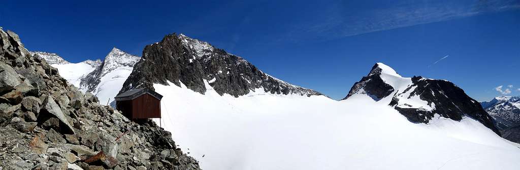
Bivouac de la Sengla
It's possible to divide the climb in two days, staying overnight at the characteristic "Bivouac de la Sengla"( 3.199m), located 30 min. from the Col d'Otemma with 12 places. Placed on the eagle nest called "l'Aiguillette" above the Glacier of Otemma. 2h'00 from the Cabane de Vignettes (F). 3h'00 from Cabane de Chanrion (F). 3h'00 from Chamen Village across del Col d'Otemma (PD).
 |
 |
 |
 |
 |
È possibile dividere la salita in due giorni, sfruttando il pernottamento al caratteristico "Bivacco della Sengla" (3.199m), situato a 30 min. dal Col d'Otemma con 12 posti letto. Posizionato sul nido d'aquila chiamato "l'Aiguillette" sopra il Ghiacciaio d'Otemma. 2h'00 dalla Cabane des Vignettes (F). 3h'00 da quella di Chanrion (F). 3h'00 dal Villaggio di Chamen attraverso il Col d'Otemma (PD).
Cabane de Chanrion
 |
 |
 |
 |
 |
Campings
Remember that free camping is forbidden (except for emergency reasons, over 2.500m, from darkness until dawn).
Mountain Conditions
- You can get meteo information at the official site of the Regione Valle d'Aosta:
- Valle d'Aosta Meteo
Webcam
- WEBCAM on Aosta Valley:
- Webcam
Books and Maps
BOOKS:
- "Guida delle Alpi Occidentali", di Giovanni Bobba e Luigi Vaccarone C.A.I. Sezione di Torino Volume II (parte II), 25 Maggio 1896.
- "Guida dei Monti d'Italia-Alpi Pennine" (Vol.I°) di Gino Buscaini-Club Alpino Italiano/Turing Club Italiano, Luglio 1971 (in Italian).
- "Diari Alpinistici" di Osvaldo Cardellina e Indice Generale accompagnato da Schedario Relazioni Ascensioni 1964-2019 (unpublished).
- "Guida della Valpelline" de l'Abbè Joseph-Marie Henry - Societè Editrice Valdotaine 1925 II Edition e Collana Reprint Musumeci (1986).
 |
 |
 |
MAPS:
- Kompass "Breuil Cervinia Zermatt" Sentieri e Rifugi Carta turistica 1:50.000.
- L'Escursionista "Valpelline, Saint Barthélemy" (carta n° 6) 1:25.000.
- I.G.C. Istituto Geografico Centrale "La Valpelline, Ollomont, Saint Barthélemy", (carta n° 115) Map1:30.000.
- Carta Nazionale Svizzera "Foglio Valpelline" 1:50.000.
Important Information
- REGIONE AUTONOMA VALLE D'AOSTA the official site.
- FONDAZIONE MONTAGNA SICURA Villa Cameron, località Villard de la Palud n° 1 Courmayeur (AO) Tel: 39 0165 897602 - Fax: 39 0165 897647.
- SOCIETA' DELLE GUIDE DELLA VALPELLINE Etroubles-Strada Nazionale, n° 13 - Tel +39 0165 78559 - Valpelline-Loc Capoluogo, n° 1 - Tel +39 0165 713502 (AO) Italia.
- A.I.NE.VA. (Associazione Interregionale Neve e Valanghe).
- METEO SUISSE
Useful numbers
- Protezione Civile Valdostana località Aeroporto n° 7/A Saint Christophe (Ao) Tel. 0165-238222.
- Bollettino Meteo (weather info) Tel. 0165-44113.
- Unità Operativa di Soccorso Sanitario Tel. 118.