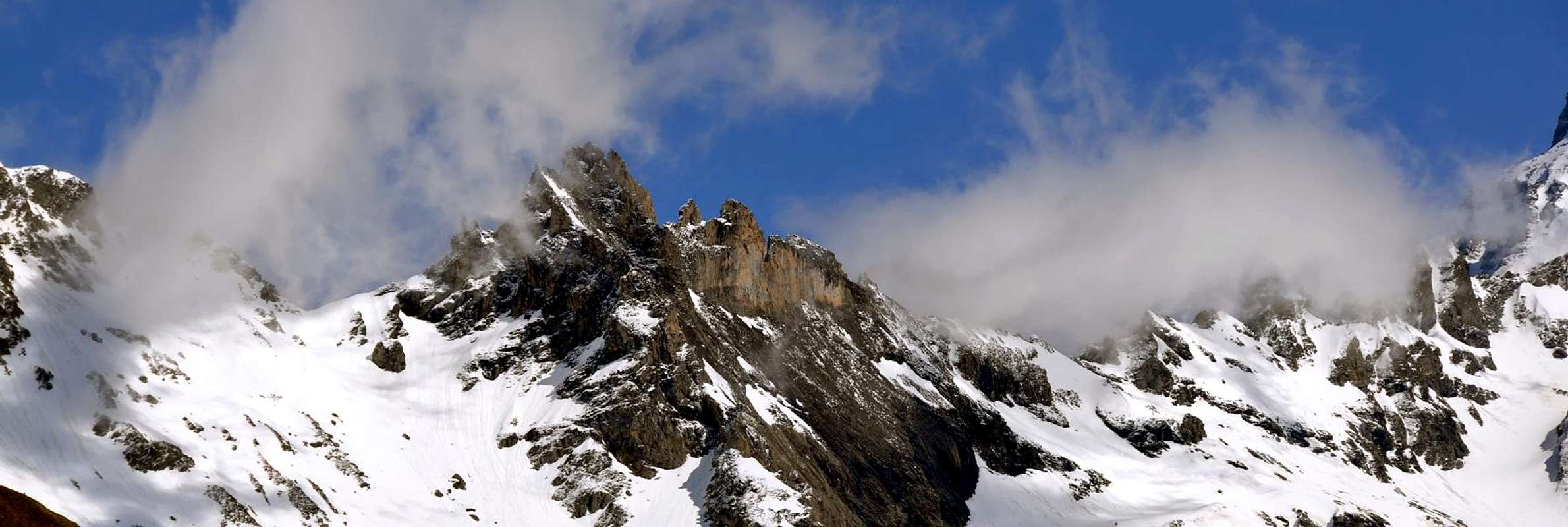
Particular mountain (known also as "I Tre Fratelli di Valsorey") with three peaks and a smaller, baptized by the Abbé Henry "Le Petite Frères" (3.190m). A little frequented for the rock (dolomia) of bad quality. Good panorama on the Mont Velan and on the south slopes of the Combins.
Montagna particolare (conosciuta anche come "I Tre Fratelli di Valsorey"), con tre vette ed una più piccola, battezzata dall'Abbé Henry "Le Petite Frères" (3.190 m). Poco frequentata per la roccia (dolomia) non molto buona. Ottimo panorama sul Mont Velan e sui versanti sud dei Combins.Montagna particolare (conosciuta anche come "I Tre Fratelli di Valsorey"), con tre vette ed una più piccola, battezzata dall'Abbé Henry "Le Petite Frères" (3.190 m). Poco frequentata per la roccia (dolomia) non molto buona. Ottimo panorama sul Mont Velan e sui versanti sud dei Combins.
First Ascent
Punta Centrale:
First on the summit (SE Slope): Alfred George Topham, Jean Maître and Pierre Maurys, (Jul 24th, 1893).
In winter: Unknown.
Punta Ovest:
First on the summit (crossing of three summits): M. Crettez and W. G. Adams, (Aug 20th, 1902).
In winter: Unknown.
SE Arête: Abbots Pantaléon Bovet, Jean Baptiste Gontier and Joseph Henry, (Jul 17th, 1908), in ascent and in descent.
W Arête: M. Crettez and W. G. Adams, (Aug 20th, 1902), in crossing.
Punta Est:
First on the summit (W-SW Arête): M. Crettez and W. G. Adams, (Aug 20th, 1902), in crossing.
In winter: Unknown.
Petite Frères:
Crossing: A. Antonini, C. Bestetti, Elvezio Bozzoli Parasacchi and Vitale Bramani, (Aug 19th, 1923).
Getting There
BY CAR:
From Torino, Milano, etc: Motorway A5. Exit at Aosta Est.
From Switzerland: through the Grand Saint Bernard Tunnel or the namesake pass.
From France: through the Mont Blanc Tunnel or Petit Saint Bernard Pass. It is not necessary to take Motorway A5: you can drive on SS.26, in the direction of Aosta.
BY PLANE:
Aeroporto "Corrado Gex" Saint Christophe (Aosta).
Itinerary
From Aosta East exit of the motorway, follow along the SS.27 for the Gran San Bernardo Tunnel After about ten Km turn to the right toward Valpelline (964m), cross it and turn to the left to get Ollomont (1.335m) and the small built area of Glacier (1.549m), where you must start walking. From the Glacier (1.549m) to climb the steep route that leads to the alpine pasture Porchère (2.094m) and the Tsa of superior Porchère (2.280m); to follow a small valley to when becomes a very steep. To continue then northwest towards a grassy back to result northeast towards the Bivouac Savoye-Rosaire (2.674m3h'00).
Dall'uscita del Casello Autostradale di Aosta Est, proseguire sulla SS.27 in direzione del tunnel del Gran San Bernardo; dopo circa un decina di chilometri svoltare sulla destra verso il Paese di Valpelline (964 m). Dopo averlo superato svoltare sulla sinistra e raggiungere il Paese di Ollomont (1.335 m); proseguire sino alla Frazione di Glacier (1.549 m), dove inizia l'itinerario a piedi. Da Glacier salire il ripido sentiero che conduce all'Alpe Porchère (2.094 m) e il superiore Tsa di Porchère (2.280 m); seguire un piccolo vallone sino a quando diviene molto ripido. Proseguire a nord-ovest verso un dosso erboso per poi voltare a nord-est verso il Bivacco Savoie-Rosaire (2.674 m3h'00).
Route
From the Bivouac Savoye-Rosaire to cross the impending grassy-rocky crest; joints to a jump to triangle, to revolve to the right it and to go up again under the carving among Central summit and East summit. To overcome a fireplace and to turn to the left on the crest that brings in peak (3h'00/6h'00). Descent: on the same route.
Dal Bivacco Savoie-Rosaire percorrere la sovrastante cresta erboso-rocciosa; giunti ad un salto a triangolo, aggirarlo a destra e risalire sotto l'intaglio tra la Punta Centrale e la Punta Est. Superare un camino e voltare a sinistra sulla cresta che porta in vetta (3h'00/6h'00). Discesa: lungo la stessa via di salita.
Difficulty
This route can be considered PD+.
L'itinerario è classificato PD+.
Equipment
Standard mountaineering equipment.
Da alpinismo.
Huts
Bivacco ROSAZZA-SAVOYE
Campings
Remember that free camping is forbidden (except for emergency reasons, over 2.500m, from darkness until dawn).
Mountain Conditions
You can get meteo information at the official site of the Regione Valle d'Aosta:
Parents refers to a larger category under which an object falls. For example, theAconcagua mountain page has the 'Aconcagua Group' and the 'Seven Summits' asparents and is a parent itself to many routes, photos, and Trip Reports.

 8106 Hits
 85.36% Score
 20 Votes